Div400: A Social Image Retrieval
Result Diversification Dataset
Bogdan Ionescu
LAPI, University Politehnica of Bucharest, Romania
[email protected]
Anca-Livia Radu
DISI, University of Trento, Italy[email protected]
María Menéndez
DISI, University of Trento, Italy[email protected]
Henning Müller
HES-SO, Sierre, Switzerland
[email protected]
Adrian Popescu
CEA-LIST, France[email protected]
Babak Loni
Delft University of Technology, The Netherlands
[email protected]
ABSTRACT
In this paper we propose a new dataset, Div400, that was de-signed to support shared evaluation in different areas of so-cial media photo retrieval, e.g., machine analysis (re-ranking, machine learning), human-based computation (crowdsour-cing) or hybrid approaches (relevance feedback, machine-crowd integration). Div400 comes with associated relevance and diversity assessments performed by human annotators. 396 landmark locations are represented via 43,418 Flickr photos and metadata, Wikipedia pages and content descrip-tors for text and visual modalities. To facilitate distribu-tion, only Creative Commons content was included in the dataset. The proposed dataset was validated during the 2013 Retrieving Diverse Social Images Task at the MediaE-val Benchmarking Initiative for Multimedia EMediaE-valuation.
Categories and Subject Descriptors
H.3.7 [Information Storage and Retrieval]: Digital Li-braries—collection, dissemination.
Keywords
social photo retrieval, result diversification, multimedia con-tent analysis, crowdsourcing, MediaEval benchmark, Flickr.
1.
INTRODUCTION
Multimedia items make for an important share of the data distributed and searched for on the Internet. In particular, geographic queries represent a hefty chunk of users’ queries. Current photo search technology is mainly relying on em-ploying text, visual, or more recently on GPS information to provide users with accurate results for their queries. Re-trieval capabilities are however still below the actual needs of the common user, mainly due to the limitations of the con-Permission to make digital or hard copies of all or part of this work for personal or classroom use is granted without fee provided that copies are not made or distributed for profit or commercial advantage and that copies bear this notice and the full citation on the first page. Copyrights for components of this work owned by others than ACM must be honored. Abstracting with credit is permitted. To copy otherwise, or republish, to post on servers or to redistribute to lists, requires prior specific permission and/or a fee. Request permissions from [email protected].
MMSys’14, March 19 - 21 2014, Singapore Copyright 2014 ACM 978-1-4503-2705-3/14/03$15.00. http://dx.doi.org/10.1145/2557642.2563670.
tent descriptors, e.g., textual tags tend to be noisy or inac-curate (e.g., people may tag entire collections with a unique tag), automatic visual descriptors fail to provide high-level understanding of the scene while GPS coordinates capture the position of the photographer and not necessarily the po-sition of the query. Until recently, research focused mainly on improving the relevance of the results. However, an effi-cient information retrieval system should be able to summa-rize search results so that it surfaces results that are both relevant and that are covering different aspects of a query (e.g., providing different views of a monument rather than duplicates of the same perspective).
In this paper we introduce a new dataset designed to sup-port this emerging area of information retrieval that fos-ters new technology for improving both the relevance and diversification of search results with explicit focus on the actual social media context. This dataset is intended to support related areas of machine analysis (e.g., re-ranking, machine learning), human-based computation (e.g., crowd-sourcing) as well as hybrid approaches (e.g., relevance feed-back, machine-crowd integration).
The paper is organized as follows: Section 2 presents a brief overview of the literature and situates our contribution. Section 3 provides the description of the dataset while Sec-tion 4 discusses the annotaSec-tion process. SecSec-tion 5 provides insights about the validation of the dataset at the MediaEval 2013 benchmark and Section 6 concludes the paper.
2.
RELATED WORK
In the context of photo retrieval, relevance was more thor-oughly studied than diversification and, even though a con-siderable amount of diversification literature exists, the topic remains a “hot” one, especially in social media [1, 2, 3, 4, 5]. One of the critical points of the diversification approaches are the evaluation tools. In general, experimental valida-tion is carried out on closed datasets which limits the re-producibility of the results. Another weakness is the ground truth annotation which tends to be restrained, not enough attention being payed to its statistical significance. Contri-butions in this area are therefore highly valuable.
Closely related to our initiative is the ImageCLEF bench-marking and in particular the 2009 Photo Retrieval task [4] that proposes a dataset consisting of 498,920 news pho-tographs (images and caption text) classified into sub-topics
(e.g., location type for locations, animal type for photos of animals) for addressing diversity. Other existing datasets are determined for the experimentation of specific methods. For instance [2] uses a collection of Flickr1 images captured around 207 locations in Paris and as ground truth exploits the geographical coordinates accompanying the images. [3] addresses the diversification problem in the context of popu-lating a knowledge base, YAGO2, containing about 2 million typed entities (e.g., people, buildings, mountains, lakes, etc) from Wikipedia. [5] uses 75 randomly selected queries from Flickr logs for which only the top 50 results are retained; diversity annotation is provided by human assessors that grouped the data into similar appearance clusters.
The main contributions of the proposed dataset are: ad-dressing the social dimension of the diversification problem that is reflected both in its nature (variable quality of photos and of metadata shared on social media) and in the methods devised to retrieve it — we use a tourist use case scenario where a person tries to find more information about a place she might visit and is interested in getting a more complete visual description of the place; providing ground truth anno-tation from both trusted assessors and crowd workers which will allow for exploring better the limits between the two as well as the annotation subjectivity; proposing a develop-ment framework (including evaluation tools) in the context of the actual retrieval technology as the dataset contains re-sults obtained with Flickr’s relevance system. These aspects are detailed in the sequel.
3.
DATASET DESCRIPTION
Given the important role of geographic queries and their spatio-temporal and visual invariance, we created a dataset composed of tourist landmarks. The dataset consists of 396 landmark locations, natural or man-made, e.g., sites, muse-ums, monuments, buildings, roads, bridges, houses, caves. They range from very famous ones, e.g., Big Ben in London, to lesser known to the grand public, e.g., Palazzo delle Al-bere in Italy. These locations were selected from the World Heritage Site of the United Nations Educational, Scientific and Cultural Organization (UNESCO)3, the CUbRIK FP7 project4 and the GEORAMA project5based on the number of redistributable photos available on Flickr.
The dataset consists of Creative Commons6 Flickr and Wikipedia location data. For each location the following in-formation is provided: location name (unique textual iden-tifier in the dataset), location id (unique numeric identi-fier), GPS coordinates (latitude and longitude in degrees) retrieved from GeoHack7 via the location Wikipedia web page, a link to its Wikipedia web page, a representative photo from Wikipedia, a ranked set of photos retrieved from Flickr (up to 150 photos), metadata from Flickr for all the retrieved photos and visual and text content descriptors8.
1http://www.flickr.com/ 2 http://datahub.io/dataset/yago/ 3http://en.wikipedia.org/wiki/List_of_World_ Heritage_Sites/ 4http://www.cubrikproject.eu/ 5 http://georama-project.labs.exalead.com/ 6http://creativecommons.org/ 7 http://tools.wmflabs.org/geohack/
8to download the dataset see http://traces.cs.umass. edu/index.php/mmsys/mmsys.
3.1
Flickr data collection method
Apart from Wikipedia data, landmark information was collected from Flickr using Flickr API9(under Java) and the flickr.photos.search function. To compare different retrieval mechanisms, for some of the locations data was collected using only the location name as query while for the other part we used the name of the location and the GPS coordi-nates. For the text queries, data are retrieved by matching the provided keywords against the photo title, description or tags (parameter &text= location name). For the queries including the GPS coordinates, data is retrieved within a 1 Km radius around the provided coordinates (&lat= latitude in degrees, &lon= longitude in degrees, and &radius=1).
For each location, we retain, depending on their availabil-ity, at most the first 150 photo results (&per_page=150). All the retrieved photos are under Creative Commons licenses of type 1 to 7 that allow redistribution9 (&license=1,2,3, 4,5,6,7). For each photo, the retrieved metadata consist of the photo’s id and title, photo description as provided by author, tags, geotagging information (latitude and longitude in degrees), the date the photo was taken, photo owner’s name, the number of times the photo has been displayed, the url link of the photo location from Flickr10, Creative Com-mon license type (&extras=description,tags,geo,date_ taken,owner_name,views,url_b,license), number of pos-ted comments (via flickr.photo.getInfo function) and the pho-to’s rank within the Flickr results (we generated a number from 1 to 150). Results were retrieved with Flickr’s default “relevance” algorithm (&sort=relevance).
3.2
Visual and textual descriptors
The raw data retrieved from Wikipedia and Flickr is ac-companied by automatically extracted visual descriptors and text models. Features are provided on an as-is basis with no guaranty of being correct.
3.2.1
Visual descriptors
For each photo, we provide the following descriptors: • global color naming histogram (code CN — 11 values): maps colors to 11 universal color names [6];
• global Histogram of Oriented Gradients (code HOG — 81 values): represents the HoG feature computed on 3 by 3 image regions [7];
• global color moments on HSV (Hue-Saturation-Value) color space (code CM — 9 values): represent the first three cen-tral moments of an image color distribution: mean, standard deviation and skewness [8];
• global Locally Binary Patterns on gray scale (code LBP — 16 values) [9];
• global Color Structure Descriptor (code CSD — 64 val-ues): represents the MPEG-7 Color Structure Descriptor computed on the HMMD (Hue-Min-Max-Difference) color space [10];
• global statistics on gray level Run Length Matrix (code GLRLM — 44 dimensions): provides 11 statistics computed on gray level run-length matrices for 4 directions: Short Run Emphasis, Long Run Emphasis, Gray-Level Non-uniformity, Run Length Non-uniformity, Run Percentage, Low Gray-Level Run Emphasis, High Gray-Gray-Level Run Emphasis, Short 9http://www.flickr.com/services/api/flickr.photos. licenses.getInfo.html/
10please note that by the time you use the dataset some of the photos may not be available anymore at the same url.
Table 1: Dataset image statistics.
devset testset
#locations #images min-avg.-max #img./location #locations #images min-avg.-max #img./location
keywords 25 2,281 30 - 91.2 - 150 135 13,591 30 - 100.7 - 150
keywordsGPS 25 2,837 45 - 113.5 - 150 211 24,709 35 - 117.1 - 150
overall 50 5,118 30 - 102.4 - 150 346 38,300 30 - 110.7 - 150
Run Low Gray-Level Emphasis, Short Run High Gray-Level Emphasis, Long Run Low Gray-Level Emphasis, Long Run High Gray-Level Emphasis [11];
• local spatial pyramid representations (code 3x3) of each of the previous descriptors (image is divided into 3 by 3 non-overlapping blocks and descriptors are computed on each patch — the global descriptor is obtained by the concatena-tion of all values).
3.2.2
Text models
Text models were created using tag and title words of the Flickr metadata. Preprocessing consist of excluding English stop words and single character words. We provide the fol-lowing models:
• probabilistic model (code probabilistic): estimates the prob-ability of association between a word and a given location by dividing the probability of occurrence of the word in the metadata associated to the location by the overall occur-rences of that word [12];
• TF-IDF weighting (code tfidf ): term frequency-inverse document frequency is a numerical statistic which reflects how important a word is to a document in a collection or corpus. The TF-IDF value increases proportionally to the number of times a word appears in the document, but is off-set by the frequency of the word in the corpus, which helps to control for the fact that some words are generally more common than others [13];
• social TF-IDF weighting (code social-tfidf ): is an adapta-tion of TF-IDF to the social space (documents with several identified contributors). It exploits the number of different users that tag with a given word instead of the term count at document level and the total number of users that con-tribute to a document’s description. At the collection level, we exploit the total number of users that have used a doc-ument instead of the frequency of the word in the corpus. This measure aims at reducing the effect of bulk tagging (i.e., tagging a large number of photographs with the same words) and to put forward the social relevancy of a term through the use of the user counts [14]. All three models use the entire dataset to derive term background information, such as the total number of occurrences for the probabilistic model, the inverse document frequency for tf-idf or the total number of users for social-tfidf.
3.3
Dataset basic statistics
The landmarks in the dataset are unevenly spread over 39 countries around the world. The dataset is divided into a development set (code devset) containing 50 of the lo-cations and whose objective is to serve for the design and training of potential approaches, and a testing dataset con-taining the remaining 346 locations (code testset) which is intended for validating the methods. Each of these datasets contain both data that was retrieved using only keywords (code keywords) and data retrieved with keywords and
GPS coordinates (code keywordsGPS — see also Section 3.1). Some basic image statistics are presented in Table 1. Overall, the dataset contains some 43,418 images together with their metadata and descriptor information.
3.4
Data format
Each dataset is stored in an individual folder (devset and testset ) containing on its turn individual folders for each category of data (keywords and keywordsGPS ). Then, each dataset sub-folder contains the following information: • a topic xml file: containing the list of the locations in the current dataset (e.g., devsetkeywords topics.xml for de-vset keywords11). Each location is delimited by a <topic> </topic> statement and includes the location id, the name of the location, the GPS coordinates and the url to the Wikipedia webpage of the location;
• an img folder: containing all the retrieved Flickr images for all the locations in the dataset, stored in individual fold-ers named after each location. Images are named after the Flickr photo ids. All images are stored in JPEG format and have a resolution of around 640× 480 pixels;
• an imgwiki folder: containing Creative Commons loca-tion photos from Wikipidia (one photo per localoca-tion12). Each photo is named after the location name and has the owner’s name specified in brackets (e.g, “Basilica of Saint Peter Vat-ican (Wolfgang Stuck).jpg”, author Wolfgang Stuck); • a xml folder: containing all the Flickr metadata stored in individual xml files. Each file is named according to the location name and is structured as in the following example:
<photos monument=“Basilica of St Mary of Health Venice”> <photo date taken=“2003-10-09 15:19:30 ” description=“The Basil-ica di Santa Maria della Salute, commonly known as ...” id=“2323 210481 ” latitude=“0 ” license=“3 ” longitude=“0 ” nbComments=
“50 ” rank=“1 ” tags=“europe italy venice ... sony f717 ”
title=“Ba-silica of St Mary of Health/Salvation, Venice” url b=“http://static.
flickr.com/2410/2323210481_31da0f0311_b.jpg”
username=“Christo-pher Chan” views=“6824 ”/> ... </photos>
The monument value is the unique location name, then, each of the photos are delimited by a <photo /> statement. Each field is explained in Section 3.1;
• a gt folder: containing all the dataset ground truth files (more details are presented in Section 4);
• a descvis folder: containing all the visual descriptors. The img subfolder contains the descriptors for the Flickr images as individual csv (comma-separated values) files on a per location and descriptor type basis. Each file is named after the location name followed by the descriptor code, e.g., “Abbey of Saint Gall CM3x3.csv” refers to the global Color Moments (CM) computed on the spatial pyramid 3x3 for the location Abbey of Saint Gall (see Section 3.2.1). Within 11for testset, there are additional topic files (ending with “ ”) which are not containing the locations with no relevant ima-ges in the ground truth (namely, ids 81, 298, 305 and 367). 12
each file, each photo descriptor is provided on an individ-ual line (ending with carriage return). The first value is the unique photo id followed by the descriptor values separated by commas. The imgwiki subfolder contains the descriptors for the Wikipedia images as individual csv files on a per data set and descriptor type basis. Each file is named ac-cording to the dataset followed by the descriptor code, e.g., “devsetkeywordsGPS-CM.csv” refers to the global Color Mo-ments (CM) for the devset keywordsGPS. As in the previ-ous case, within each file, each Wikipedia photo descriptor is provided on an individual line (ending with carriage return). The first value is the Wikipedia photo file name followed by the descriptor values separated by commas;
• a desctxt folder: containing all the text models pro-vided on a per dataset and model type basis. Each file is named according to the dataset followed by the descriptor code (see Section 3.2.2), e.g., “devsetkeywordsGPS-social-tfidf.txt” refers to the social TF-IDF weighting for the de-vset keywordsGPS. It contains a line for each location in the current dataset representing the model for that loca-tion (ending with carriage return). Columns are separated by tabulations. The first column of the line is the loca-tion name and the other columns contain each related word and its associated weight (associated words are sorted by decreasing scores).
4.
DATASET ANNOTATION
The ground truth annotation of the dataset is strictly de-pendent on the use scenario intended for the dataset. As presented in Section 2, the proposed dataset was annotated in view of a tourist use case scenario where a person tries to find more information about a place she might visit. The dataset is annotated for relevance and diversity of the pho-tos. The main annotation process was performed by experts (trusted annotators). To explore differences between expert and non-expert annotations, an additional crowd-sourcing annotation was generated for a selection of 50 locations from the testset. Dedicated visual software tools were employed to facilitate the process. The following definitions of relevance and diversity have been adopted:
• relevance: a photo is considered to be relevant for the lo-cation if it is a common photo representation of the lolo-cation, e.g., different views at different times of the day/year and under different weather conditions, inside views, close-ups on architectural details, drawings, sketches, creative views, etc, which contain partially or entirely the target location. Bad quality photos (e.g., severely blurred, out of focus, etc) as well as photos showing people in focus (e.g., a big picture of me in front of the monument) are not considered relevant; • diversity: a set of photos is considered to be diverse if it depicts different visual characteristics of the target location (see the examples above), with a certain degree of comple-mentarity, i.e., most of the perceived visual information is different from one photo to another.
4.1
Annotations from trusted annotators
Trusted annotators have an advanced knowledge of the locations characteristics.4.1.1
Task design
Relevance annotation task. For each location, the anno-tators were provided with one photo at a time. A reference photo of the location (e.g., the Wikipedia photo) was also
displayed during the process. Annotators were asked to clas-sify the photos as being relevant (score 1), non-relevant (0) or with “don’t know” answer (-1). The definition of relevance was displayed to the annotators during the entire process. The annotation process was not time restricted. Annota-tors were recommended to consult any additional written or visual information source (e.g., from Internet) in case they were unsure about the annotation.
Diversity annotation task. Diversity is annotated only for the photos that were judged as relevant in the previous rel-evance step. For each location, annotators were provided with a thumbnail list of all the relevant photos. The first step required annotators to get familiar with the photos by analyzing them for about 5 minutes. Next, annotators were required to re-group the photos in clusters based on visual similarity. The number of clusters was limited to maximum 20. Full size versions of the photos were available by click-ing on the photos. The definition of diversity was displayed to the annotators during the entire process. For each of the clusters, annotators provided also some keyword tags reflecting their judgments in choosing these particular clus-ters. The diversity annotation was also not time restricted.
4.1.2
Annotation statistics
The relevance ground truth for the devset was collected from 6 different expert annotators and the diversity one was collected from 3 experts that annotated distinct parts of the data set. For the testset, we employed 7 expert annotators that annotated different parts of the dataset leading in the end to 3 different annotations while the diversity ground truth was collected from 4 expert annotators that annotated distinct parts of the data set. Annotators were both females and males with ages ranging from 23 to 34. Final relevance ground truth was determined after a lenient majority voting scheme (equal numbers of 1 and 0 lead to a 1 decision, -1 are disregarded if not in majority).
The agreement among pairs of annotators was calculated using Kappa statistics, which measure the level of agreement discarding agreement given by chance. Kappa values range from 1 to -1, where values from 0 to 1 indicate agreement above chance, values equal to 0 indicate equal to chance, and values from 0 to -1 indicate agreement worse than chance. In general, Kappa values above 0.6 are considered adequate and above 0.8 are considered almost perfect [16].
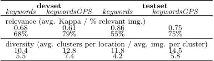
Annotation statistics are summarized in Table 2 (for de-vset we report weighted Kappa and for testset Free-Marginal Multirater Fleiss’ Kappa [16]). The relevance task statistics indicate a good agreement between annotators as well as the fact that retrieval using keywords and GPS data yields more accurate results than using solely the keywords. In to-tal there were only 14 cases in which the majority voting is “don’t know” (less than 0.04%, which is negligible). For the diversity annotation, overall, on average we obtain 11.6 clus-ters per location and 6.45 images per cluster for the devset and 13.2 and 5 for the testset, respectively.
4.2
Annotations from crowd workers
To explore differences between experts and non-experts annotations, the CrowdFlower13 meta-crowdsourcing plat-form was used to annotate a subset of 50 locations from the testset (the actual list of locations is available in the test-setcrowd topics.xml topic file, see Section 3.4 and 4.3). 13
Table 2: Expert annotation statistics.
devset testset
keywords keywordsGPS keywords keywordsGPS relevance (avg. Kappa / % relevant img.)
0.68 0.61 0.86 0.75
68% 79% 55% 75%
diversity (avg. clusters per location / avg. img. per cluster)
10.4 12.8 11.8 14.5
5.5 7.4 4.2 5.8
4.2.1
Task design
Crowd-sourcing workers performed the relevance and di-versity task annotations using the exact conditions described in Section 4.1.1, except for the fact that for the relevance an-notation photos were annotated in sets of ten. Each set of pictures that was annotated for relevance was paid with 10 euro cents while for the diversity annotation workers were paid with 35 euro cents per location.
4.2.2
Quality control procedure
For the relevance task, the quality of the crowd-sourcing task was ensured using gold units. Gold unit is a quality con-trol mechanism provided by CrowdFlower which consists in including unambiguous questions to select trusted annota-tions. Each annotator should at least answer four gold units with a minimum accuracy of 70% in order to be included in the set of trusted annotators. No trusted annotators are excluded from the final set of results. As recommended by CrowdFlower, 10% of the tasks were flagged as gold. For this purpose, a set of six additional locations and ten pictures re-lated to each of them were collected. These locations were not included in the dataset. The set of collected pictures were unambiguously relevant or non-relevant.
Due to the subjective nature of the diversity task, gold units could not be used in a traditional way. Instead, an ad-hoc website was developed and made available in the crowd-sourcing task. Crowd-crowd-sourcing workers accessed the task via CrowdFlower. The CrowdFlower task contained the descrip-tion of the task, an example of how to complete it, an open text field and a link to an external website which provided an interactive visual interface featuring drag and drop func-tionality to facilitate the annotations. After reading the de-scription and looking at the example, crowd-sourcing work-ers were accessing the external interface. Here, they could cluster the set of relevant pictures on per individual loca-tion basis. Once all pictures were clustered, the interface provided a unique code that needed to be filled in the text field of the CrowdFlower task. In order to ensure quality, the open text field was flagged as gold unit and unique codes for all locations were provided in advance.
4.2.3
Annotation statistics
In total, 175 crowd-sourcing workers participated in the relevance task. On average, each worker performed 10.7 tasks (with a minimum of 3 and a maximum of 55). For each photo we retain three annotations. Final relevance ground truth was determined after the same lenient majority voting scheme as for trusted annotators (see Section 4.1.2). An-notation statistics are summarized in Table 3 (we report Free-Marginal Multirater Fleiss’ Kappa [16]). In this case, one can observe that the agreement between annotators is significantly lower than for the trusted annotators (see Table 2) which proves the variable quality of crowd annotations.
Table 3: Crowd annotation statistics. testset (selection of 50 locations, 6169 photos)
relevance (avg. Kappa and % relevant img.): 0.36 69% diversity (avg. clusters per location / avg. img. per cluster)
GT1 GT2 GT3
3.5 4.3 6.3
43.1 30.4 24
In total there were 62 cases in which the majority voting is “don’t know” (around 1%). For the diversity task, there were in total 33 workers participating to the task. Workers per-formed an average of 11.8 tasks (with a minimum of 6 and a maximum of 24). We retain only three different annotations per location (selected empirically based on the coherence of the tags and number of clusters) for which, overall, on aver-age we obtain 4.7 clusters per location and 32.5 imaver-ages per cluster.
4.3
Annotation data format
Ground truth is provided on a per dataset, annotator type and location basis (see the folder structure in Section 3.4). Within the gt folder, relevance task ground truth is stored in the rGT subfolder and diversity task ground truth in the dGT subfolder. We provide individual txt files for each lo-cation. Files are named according to the location name fol-lowed by the ground truth code: rGT for relevance, dGT for diversity and dclusterGT for the cluster tags, e.g., “Abbey of Saint Gall dGT.txt” refers to the diversity ground truth for the location Abbey of Saint Gall.
For the rGT files, each file contains photo ground truth on individual lines (ending with carriage return). The first value is the unique photo id from Flickr followed by the ground truth value (1, 0 or -1) separated by comma. The dGT files are structured similarly to rGT but having after the comma the cluster id number to which the photo was assigned (a number from 1 to 20). The dclusterGT files, complements the dGT by providing the cluster tag informa-tion. Each line contains the cluster id followed by the cluster user tag separated by comma.
The crowd-sourcing annotation ground truth respects the formatting above but is stored in the crowdsourcing folder of testset together with its associated topic xml file (see Section 3.4). Each individual worker diversity ground truth is stored in a different subfolder (dGT1 to dGT3 ).
5.
MEDIAEVAL 2013 VALIDATION
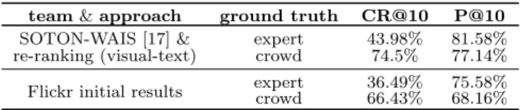
The proposed dataset was validated during the 2013 Re-trieving Diverse Social Images Task at the MediaEval Bench-marking Initiative for Multimedia Evaluation17. The task challenged participants to design either machine, human or hybrid approaches for refining Flickr results in view of pro-viding a ranked list of up to 50 photos that are considered to be both relevant and diverse representations of the locations (for more details about the task see [15]).
In total, 24 teams from 18 countries registered to the task and 11 crossed the finish line. The proposed diversification approaches varied from graph representations, re-ranking, optimization approaches, data clustering to hybrid approa-ches that included human in the loop. Various combination of information sources have been explored. System perfor-mance was assessed in terms of cluster recall at X (CR@X — a measure that assesses how many different clusters from
Table 4: MediaEval 2013 results (top performance). team & approach ground truth CR@10 P@10
SOTON-WAIS [17] & expert 43.98% 81.58% re-ranking (visual-text) crowd 74.5% 77.14% Flickr initial results expertcrowd 36.49%66.43% 75.58%68.16%
the ground truth are represented among the top X results), precision at X (P@X — measures the number of relevant photos among the top X results) and their harmonic mean, i.e., F1-measure@X (X∈{5,10,20,30,40,50}). Table 4 sum-marizes some of the best overall average results (for more details see the MediaEval workshop proceedings17). High-est performance for a cutoff at 10 images (used for the official ranking) was achieved using a re-ranking approach with a Greedy Min-Max similarity diversifier and using both visual and text information [17]. In terms of diversity, on average, it allows for an improvement close to 10% of Flickr initial ranking results (regardless the type of ground truth).
The following information will help reproducing the exact evaluation conditions of the task. Participant runs were pro-cessed in the form of trec topic files14, each line containing the following information separated by whitespaces: qid iter docno rank sim run id, where qid is the unique query id (see the topic files, Section 3.4), iter gets disregarded (e.g., 0), docno is the unique Flickr photo id, rank is the new photo rank in the refined list (an integer ranging from 0 — highest rank — up to 49), sim is a similarity score and run id is the run label. A sample run file is provided in the root of the testset folder (me13div Example run visual [dataset].txt ).
The official scoring tool, diveval.jar, is available in the root of the testset folder. To run the script, use the following syntax (make sure you have Java installed on your machine): java -jar div eval.jar -r <runfilepath> -rgt <rGT path>
-dgt <dGT path> -t <topic filepath> -o <output dir>
[optional: -f <filename>]; where <runfilepath> is the file path of the run file, <rGT path> is the path to the rele-vance ground truth, <dGT path> is the path to the diver-sity ground truth, <topic filepath> is the file path to the topic xml file (official evaluation was carried out on all the locations with relevant pictures11).
6.
CONCLUSIONS
We proposed a new dataset (Div400) that contains 396 landmark locations and 43,418 Creative Commons Flickr ranked photos together with their Wikipedia and Flickr meta-data and some general purpose content descriptors (visual and text). Data was annotated for both the relevance of the results as well as for their diversity using trusted and crowd annotators. The dataset is intended for supporting research in areas related to information retrieval that focus on the diversification of search results and was successfully validated during the 2013 Retrieving Diverse Social Images Task at the MediaEval Benchmarking Initiative.
7.
ACKNOWLEDGMENTS
This data set was supported by the following projects: 14
http://trec.nist.gov/trec_eval/
EXCEL POSDRU, CUbRIK4, PROMISE15and MUCKE16. We acknowledge the MediaEval Benchmarking Initiative for Multimedia Evaluation17 and in particular Martha Larson and Gareth Jones for the very constructive discussions.
8.
REFERENCES
[1] A.-L. Radu, B. Ionescu, M. Men´endez, J. St¨ottinger, F. Giunchiglia, A. De Angeli, “A Hybrid Machine-Crowd Approach to Photo Retrieval Result Diversification”, Multimedia Modeling, Ireland, 2014.
[2] S. Rudinac, A. Hanjalic, M.A. Larson, “Generating Visual Summaries of Geographic Areas Using
Community-Contributed Images”, IEEE Transactions on Multimedia, 15(4), pp. 921-932, 2013.
[3] B. Taneva, M. Kacimi, G. Weikum, “Gathering and Ranking Photos of Named Entities with High Precision, High Recall, and Diversity”, ACM Web Search and Data Mining, pp. 431-440, 2010.
[4] M.L. Paramita, M. Sanderson, P. Clough, “Diversity in Photo Retrieval: Overview of the ImageCLEF Photo Task 2009”, ImageCLEF 2009.
[5] R.H. van Leuken, L. Garcia, X. Olivares, R. van Zwol, “Visual Diversification of Image Search Results”, ACM World Wide Web, pp. 341-350, 2009.
[6] Van de Weijer, C. Schmid, J. Verbeek, D. Larlus, “Learning color names for real-world applications”, IEEE Transactions on Image Processing, 18(7), pp. 1512-1523, 2009.
[7] O. Ludwig, D. Delgado, V. Goncalves, U. Nunes: “Trainable Classifier-Fusion Schemes: An Application To Pedestrian Detection”, Intelligent Transportation Systems, 2009.
[8] M.Stricker, M. Orengo, “Similarity of color images”, SPIE Storage and Retrieval for Image and Video Databases III, vol. 2420, pp. 381-392, 1995.
[9] T. Ojala, M. Pietik¨ainen, D. Harwood, “Performance evaluation of texture measures with classification based on Kullback discrimination of distributions”, IAPR Pattern Recognition, vol. 1, pp. 582-585, 1994.
[10] B. S. Manjunath, J. R. Ohm, V. V. Vasudevan, A. Yamada, “Color and texture descriptors”, IEEE Transactions on Circuits and Systems for Video Technology, vol. 11(6), pp. 703-715, 2001.
[11] X. Tang, “Texture Information in Run-Length Matrices”, IEEE Transactions on image Processing, vol.7(11), 1998. [12] J.M. Ponte, W.B. Croft, “A Language Modeling Approach
to Information Retrieval”, Research and Development in Information Retrieval, pp. 275-281, 1998.
[13] G. Salton, M.J. McGill, “Introduction to modern information retrieval”, McGraw-Hill, NY, USA, ISBN:0070544840, 1986.
[14] A. Popescu, G. Grefenstette, “Social Media Driven Image Retrieval”, ACM ICMR, April 17-20, Trento, Italy, 2011. [15] B. Ionescu, M. Men´endez, H. M¨uller, A. Popescu,
“Retrieving Diverse Social Images at MediaEval 2013: Objectives, Dataset and Evaluation”, MediaEval 2013 Workshop, Barcelona, Spain, October 18-19, 2013 [16] J.J. Randolph, “Free-Marginal Multirater Kappa
(multirater κfree): an Alternative to Fleiss Fixed-Marginal Multirater Kappa”, Joensuu Learning and Instruction Symposium, 2005.
[17] N. Jain, J. Hare, S. Samangooei, J. Preston, J. Davies, D. Dupplaw, P. Lewis, “Experiments in Diversifying Flickr Result Sets”, MediaEval 2013 Workshop, Barcelona, Spain, October 18-19, 2013 15 http://www.promise-noe.eu/ 16http://www.chistera.eu/projects/mucke/ 17 http://www.multimediaeval.org/