University of Calabria Cosenza (Italy) 3-4 May, 2006
Observing and modelling
exceptional floods and rainfalls
1
stInternational Workshop on Hydrological Extremes
The workshop is a contribution of the AMHY-FRIEND group, topic “Extreme events”, to UNESCO IHP-VI (2002-2007)
Proceedings of the Workshop
Edited by
E. Ferrari and P. Versace
Soil Protection Department Faculty of Engineering University of Calabria (Italy)
Scientific Committee
Vito Copertino (Potenza, Italy) Fabrizio Ferrucci (Cosenza, Italy)
Maria Carmen Llasat (Barcelona, Spain) Eric Servat (Montpellier, France)
Pasquale Versace (Cosenza, Italy)
Organizing Committee
E. Ferrari (Chairman), D. L. De Luca, F. Cruscomagno, D. Biondi, G. Capparelli, V. De Matteis, M.A. Longo, D. Maletta, A. Senatore, T. Zaffino, G. Calcagno, F. Casacchia (all at Camilab,
http://www.camilab.unical.it)
With the Sponsorship
patronage of
The authors are responsible for the choice and presentation of the viewpoints and information contained in their articles, which in no way commit UNESCO. The designations employed and the presentation of data throughout this publication do not imply the expression of any opinion whatsoever on the part of UNESCO concerning the legal status of any country, territory, city or area or of its authorities, or concerning the delimitation of its frontiers or boundaries.
This book is dedicated to the memory of VIOREL ALEXANDRU STANESCU (1933–2006)
Viorel Alexandru Stanescu was the founder of the vanguard team in Romanian Hydrology. During his career he produced many highly valuable studies concerning the mathematical modelling of hydrologic phenomena.
After the engineer degree at the Bucharest Polytechnic Institute in 1956, he joined to the “Danube delta” team and then he was lead researcher at the Hydrology Department of the Institute of Hydrotechnics Studies and Research.
Finally he worked as a researcher at the Institute of Meteorology and Hydrology of Romania, which he directed for many years, and as professor at the Technical University of Civil Engineering Bucharest. While accomplishing these tasks, he proved his remarkable human qualities, his emotional and intellectual nobility, his creativity and social skills, leaving behind valuable followers to whom he has passed down something of his knowledge and more importantly from his passion and dedication.
Due to his studies and researches in the domain of Hydrology, Viorel Alexandru Stanescu became part of the hydrologists’ world elite and was elected as expert in several international organizations. He published thirteen books, manuals and university courses and over 140 scientific works in Romania and abroad. He was rewarded for his activity with Romanian Academy awards, was a member of honour of the Hungarian Society of Hydrology and the president of the Romanian Association of Hydrology Sciences.
Among the many international projects that he coordinated with enthusiasm, since the early years he took part in the scientific activities of AMHY-FRIEND group for UNESCO, soon becoming a guide for all the colleagues who met him and greatly appreciated his unforgettable qualities as a man and scientist.
The reciprocal exchange of information and knowledge among researchers of extreme natural events and civil protection managers, daily involved in forecasting, coping or managing emergencies caused by hydrological and geological disasters, is an important task necessary for allowing the Institutions to face rapidly and efficiently with very dangerous situations.
From many years the Civil Protection Division of Calabria Region has started collaboration with the Research Institutions working throughout the territory, with the aim of make available tools for forecasting and prevention of occurrences of damaging events or to cope with emergency situations through the best available technologies.
Standard activity of Civil Protection Division concerns technological developments, through the standard use of high technology systems (regional warning systems, emergency telecommunications systems, geographical informative systems for emergency management), operative application of models and studies produced by experts in hydrological and geological risks, diffusion of knowledge of phenomena through promotion of specific studies and spreading activities of risk knowledge among people.
Within these activities, Civil Protection Division of Calabria Region has intended to support the International Workshop on Hydrological Extremes “Observing and modelling
exceptional floods and rainfalls” which took place at the University of Calabria on 3rd and
4th May 2006, considering it as an opportunity greatly useful to promote comparison
among researchers and managing personnel of Institutions and Administrations coping with hydrological extremes, working all over the countries within Mediterranean area.
It is an important occasion to promote exchange of experience and circulation of ideas that can contribute to better develop the scientific substratum in which Civil Protection Division of Calabria Region operates. The chance becomes even more meaningful for Calabria Region since different scientific contributions have been presented by engineers daily engaged in the regional Civil Protection structures, thus proving in such an eminent international assembly the high scientific levels reached in activities realized by the Civil Protection Division of Calabria Region.
Raffaele Niccoli
Manager of Civil Protection Division,
Contents
Foreword VII
Analysis of hydrological extreme events in AMHY-FRIEND group Ferrari E.
1
Part 1
RECENT CASE STUDIES OF EXTREME HYDROLOGICAL EVENTS
Comparison between probabilistic and deterministic models to analyse flash floods events recorded in Catalonia, 2000-2005
Altava-Ortiz, V., Barrera A., Llasat M.C. and Prat M.A.
11
Exceptional flood of 22nd September 2002 in Erzeni River, Albania
Bogdani M. and Selenica A.
25
Recent extraordinary floods in Bulgaria Dakova S.
35
The exceptional event of November 12th-13th 2004: performance of the
Civil Protection monitoring system of Calabria Region Arcuri S., De Felice L. Iiritano G. and Niccoli R.
43
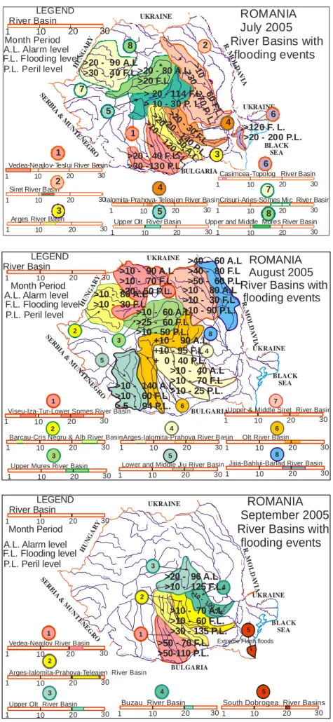
Great floods in Romania in 2005. Lessons on preparedness and prevention role in flood control
Stanescu V. A. and Drobot R.
55
The destruction of the bridge over the Ziliana Stream (Greece) on 28th
November 1998
Vafiadis M. and Efthymiou N.
71
Part 2
STATISTICAL AND STOCHASTIC ANALYSIS OF EXTREME EVENTS
The flooded areas risk. Arges basin application Adler M. J., Amafteesei R., Mic R. and Stanescu V.A.
81
Structural characteristic of maximum flows in Eastern Black Sea region, Turkey
Aksoy H., Kaynar L. and Ünal N.E.
91
Approche methodologie de calcul du debit pluvial en cas d’insuffisance de donnees. cas de la region de Tipaza, Algerie
Bouaïchi I., Touaibia B. and Dernouni F.
101
Rainfall and runoff predetermination in Mediterranean climate: regional and historical approaches
Neppel L., Niel H. and Bouvier C.
109
Development of a regional flood frequency analysis using L-moments approach for gauged and ungauged catchments of Sicily
Noto L. V., La Loggia G. and Cannarozzo M.
Investigation into rainfall variability at monthly time aggregation scale Sirangelo B. and Ferrari E.
149
Modelisation du regime de crue des bassins versants: application et utilite des hydrogrammes synthetiques mono–frequence HSMF
Yahiaoui A. and Touaibia B.
161
Regional frequency analysis of rainfall extremes in Tuscany Caporali E., Cavigli E. and Petrucci A.
173
Part 3
ADVANCES IN PEAK RIVER FLOW MODELLING THROUGH RAINFALL RUNOFF MODELS
Flood simulation and estimation in the Tevere River: a deterministic and probabilistic approach
Bacchi B., Grossi G., Pennesi L., Potenza P., Ranzi R. and Schiavoni A.
183
Snowmelt runoff influence on floods evolution within the experimental basin of “Fiumarella of Corleto” (Southern Italy)
Carriero D., Manfreda S. and Fiorentino M.
201
Rainfalls and hydrometric thresholds for flood warning. The Esaro River case study
Mendicino G.
213
Recent improvements in modelling extreme floods on Mediterranean French catchments
Bouvier C., Marchandise A. and Brunet P.
229
Flash flood occurrence versus IDF curves estimation Vafiadis M.
239
Calibration and validation of a rainfall-runoff model simulating infiltration and saturation excess
Versace P., Sirangelo B. and Biondi D.
245
Measurement of river velocity and discharge on the Dragona River experimental basin
Brilly M., Vidmar A., Padežnik M. and Mikoš M.
263
Hydrological analysis of a rainfall event in Calabria Caloiero T., Fusto F., Iiritano G. and Mendicino G.
273
INVITED LECTURE
Remote sensing for prevention analysis of tsunami in Sri Lanka Ferrucci F
FOREWORD
This book contains the proceedings of the 1st International Workshop on Hydrological
Extremes that was held in Cosenza (Italy) on 3rd and 4th May, 2006, at the University of
Calabria, with the title “Observing and modelling exceptional floods and rainfalls”. It coped both with case studies of damaging floods and rainfalls and with advances in statistical analysis of hydrological extremes, mainly focusing at the researches developed for the topic “Extreme events” of AMHY (Alpine and Mediterranean Hydrology) group within FRIEND (Flow Regimes from International Experimental and Network Data) project, which is one of the crossing themes of the IHP-VI phase of UNESCO.
For over a decade all the people involved in AMHY–FRIEND group shared investigations on rare floods and heavy rainfalls and exchanged experiences in appointments like the present workshop, that was attended by national coordinators and researchers coming from 11 Mediterranean countries (Albania, Algeria, Bulgaria, France, Greece, Italy, Romania, Spain, Slovenia, Turkey, Yugoslavia). The relevance of the workshop is closely related to the increased vulnerability from hydrological events observed in the represented countries.
The workshop was divided in three sessions: Recent case studies of heavy rainfalls and floods (chairman M. Lang), Statistical and stochastic analysis of extreme events (chairman B. Bacchi), Advances in peak river flow modelling through rainfall-runoff models (chairpersons M.C. Llasat and V.A. Stanescu). A total of 24 works were presented and interesting discussions were raised. A brief outlook of the topic in charge of the international coordinator and the open discussion of proposals for defining future outlook of the topic concluded the workshop.
As collateral events followed: an invited lecture on “Remote sensing for prevention analysis of tsunami in Sri Lanka” by prof. F. Ferrucci (Project manager of Master Carthema, University of Calabria), a poster session of works on risk mapping by students of Master Carthema and the delivery of two thesis awards in memory of prof. Carlo Colosimo.
I wish to thank Camilab, Soil Protection Department and Master Carthema of University of Calabria for financing the workshop and the Civil Protection Division of Calabria Region for supporting this book. Thanks also to the Scientific Committee for judgments and suggestions on works and to all the people who helped in the organisation. The workshop has confirmed once again the competence and the friendship among all the participants involved in the project, thus renewing our common believe that FRIEND could be not only the acronym of a scientific project but also a meaningful attempt to share knowledge and social interaction among people.
Ennio Ferrari
International coordinator of topic “Extreme events”, AMHY-FRIEND group
Observing and modelling exceptional floods and rainfalls
Proceedings of the AMHY-FRIEND International Workshop on Hydrological Extremes, held at University of Calabria, Cosenza (Italy), May 3-4, 2006
ANALYSIS OF HYDROLOGICAL EXTREME EVENTS IN AMHY-FRIEND GROUP
E. Ferrari
Department of Soil Protection “V. Marone”, University of Calabria, Cosenza, Italy
ABSTRACT
In this work are briefly reviewed the main research lines and results related to the analysis of some hydrological extremes performed in recent years by the working groups involved in AMHY-FRIEND project, firstly as “Heavy rains” and “Rare floods” separate topics and then as “Extreme events” topic. Finally a synthetic presentation of both ongoing researches and outlooks for this latter new topic is shown.
1. INTRODUCTION
The AMHY (Alpine and Mediterranean Hydrology) group of FRIEND (Flow Regimes from International Experimental and Network Data) project covers a large range of topics, including frequency analysis of floods and low flow, investigation on Mediterranean storms, rainfall-runoff transformation, erosion and sediment transport and climate change (Afouda et al., 1997; Gustard and Cole, 2002). Particularly for over a decade the international working groups involved in the analysis of intense rainfalls and floods have experienced common approaches to hydrological extreme frequency analysis, by applying various standard procedures to data base collected in different hydrological regions.
Until 2003 these working groups mainly coped with “Heavy rains” “Rare floods” topics separately, though often in a synergic way since the common objective of the characterization of the meteorological and hydrological sequences of events triggering flooding disasters. To this aim some specialized seminars about heavy rains and flash floods have been jointly organised within the activities of the IV (Rare Floods) and VI (Heavy Rains) topics, like it was during the annual meeting of AMHY-FRIEND group held on October 1998 at the Istanbul Technical University (Turkey) and on October 1999 at the University of Calabria (Cosenza, Italy). In these joint seminars, besides theoretical developments mainly related to the statistical analysis of rainfall and flood phenomena, several cases of flash floods produced by heavy rainfalls on different areas of Mediterranean countries (from small basins to very large drainage networks) have been analysed in detail, taking into account morphology, geology, land use and basin response to flood depending on antecedent moisture conditions (Llasat et al., 1999).
1.1 Researches on “Heavy rains” topic
The main scientific activity of topic "Heavy rains", coordinated by M.C. Llasat (Spain), coped with the analysis of extreme rainfall events from meteorological, climatic and hydrological points of view. All countries involved in AMHY-FRIEND project participated actively to the researches, with Spain, France, Italy, Romania, Greece,
former Yugoslavia, Slovenia, Turkey and Moldavia among the most operative in rainfall researches. Particularly the Spanish GAMA group from University of Barcelona devoted great attention to the analysis of the meteorological and hydrological conditions triggering extreme rainfall events, in order to define features for classify different typologies of exceptional rainfalls. The exhaustive investigations allowed for assessments on the reliability of the most commonly used methodologies for the spatial characterization of convective storms. Results obtained through different approaches based on physical features of short time rainfall data taken from the meteorological radar, supported by rain gauges observations, provided a proposal of classification of precipitation structures in Mediterranean area (Gustard and Cole, 2002).
Good results came also from investigations focused on other specific questions about rainfall features, such as the analysis of anomalies in monthly rainfalls at large spatial scale, the possibility to obtain reliable regionalization of the different rainfall behaviours in Mediterranean countries, the optimal boundaries for obtaining practical results from these regional analyses, the relationships between physiographic and morphological features of basins and extreme rainfall data at different temporal aggregation for preliminary applications to ungauged basins.
Other scientific activities included simulations of rainfall hyetographs, intensity-duration-frequency analysis, performance analysis of the most common regional rainfall frequency distributions, rainfall forecasting, influence of relief on rainfall probabilistic distributions, climate evolution, stochastic analysis of non-periodic component of the annual and monthly rainfall process, implementation and enlargement of data bases of hydrological extreme events for European regions (Afouda et al., 1997; Gustard and
Cole, 2002).
1.2 Researches on “Rare floods” topic
Topic "Rare floods", coordinated by P. Versace (Italy), has been mainly directed at improving theoretical knowledge of flood phenomena and testing statistical procedures for flood frequency estimation. Most of the countries involved in AMHY-FRIEND contributed to the researches with very good analyses (France, Greece, Italy, former Yugoslavia, Spain, Turkey, Greece, Bulgaria, Albania, Romania and Slovenia).
Aiming at the practical mitigation of the inundation risk through a better estimation of flood with specified return period, attention has been focused on both at-site and regional estimation techniques of parameters of the most used probabilistic distributions.
As regards regional flood estimations, investigations based on the robustness and prediction capacity of some regional flood evaluation models commonly used in Europe (among the others the VAPI procedure in Italy, the AGREGEE model in France, the Modified Rational Method in Spain) were performed. These researches were validated in a crossed way on different national hydrological archives, thus encouraging improvement and synthesis of the various procedures. To this aim, some specific characteristics of the models have been successfully transferred from one method to another, thus pointing out the different features of flexibility and robustness of the regional models.
Meaningful improvements were obtained also in at-site flood evaluation procedures with important results obtained for flood quantile estimation, mainly for the interesting developments in data acquisition and analysis, concerning mainly the peaks over threshold sampling techniques, the use of historical information, new synthetic
Analysis of hydrological extreme events in AMHY-FRIEND group
Another important research developed in “Rare flood” topic has been the exploitation of the links between flash floods and heavy rains, due to the increased frequency of floods caused by high intensities and short duration rainfalls. The interest in this issue is claimed by civil protection administrations for the shortage of time to activate any safeguard measures in the territories suffering from high risk of flash floods. These ongoing researches have tried to detect common meteorological and hydrological features responsible for the production of flash floods from the comprehensive rainfall-runoff analysis of some damaging event recently occurred in Mediterranean countries.
2. LATE SCIENTIFIC ACTIVITIES ON “EXTREME EVENTS” TOPIC
The ”Extreme events” topic of AMHY-FRIEND group comes from the merging of the previous ”Heavy rains” and ”Rare floods” topics, discussed by the Steering Committee of AMHY-FRIEND project during the International Conference on Hydrology of the Mediterranean and semi-arid regions, held in Montpellier (France) on April 2003.
The scientific activities of the ”Extreme events” topic, taking advantage of the skills of the various researchers previously interested in one of the topics described in section 1.1 and 1.2, mainly copes with comprehensive analyses of rainfall and flood events, also considering the physical links between phenomena as in the case of rainfall-runoff modelling.
In continuity with the past, attention is also given to comparative synoptic analyses of hydrological and meteorological data from simultaneous heavy rainfall events, which can produce floods in geographically distant regions with specific climatic features. The goal of the research is a better identification of the features triggering hydrological extremes and the comprehension of the rainfall-runoff dynamics of the different European climatic environments. Moreover several AMHY working groups involved in ”Extreme events” topic have produced (or collaborated to) scientific reports concerning hydrological and meteorological analysis of the most damaging extreme events, in some cases also accounting for societal impacts and people perception of the events.
2.1 Development of rainfall analysis
Characterization of heavy rainfalls in Mediterranean area.
Exceptional storms recently occurred in the Mediterranean area have induced revision of the statistical distributions for rainfall estimation, particularly as regards the asymptotic tails over extreme values. To this aim, some regionalized approaches of heavy tailed probability distributions for estimation of rare daily rainfalls have been explored, for example through the statistical analysis of the coefficient of variation of the annual maximum daily rainfalls. The improved regional distributions have led to a significant increase in the estimation of rarer rainfall depths.
Other statistical analyses on heavy rainfalls events have been performed for FRIEND project in some regions of Europe (among the others: France, Portugal, Serbia and Italy), with results such as the frequency evaluation of rainfall events measured at large spatial scale, the intensity-duration-frequency curves for different return periods and basin area, the local estimations of probable maximum precipitation and empirical relationships for hourly and sub-hourly rainfalls.
Detection of trends, shifts and seasonality in precipitations.
Assessments on the possible existence of trends, shifts and seasonality in precipitations has been accomplished by means of the analyses of occurrence and magnitude of short duration rainfalls and, at a larger temporal scale, through trend analysis of cumulated monthly and annual precipitations. Principal aims of these ongoing researches, jointly performed by some working groups, are the comparison of the rainfall variability features in different regions and the detection of local relationships between short duration rainfalls and cumulated rainfalls at larger time scale.
The results have shown to depend on the time aggregation of the data and on the physical and climatic features of the examined area. In particular, evidence of significant decreasing trends in winter monthly rainfall values recorded in the most recent decades in southern Italy have been pointed out. On the contrary, anomalies and trend analyses of monthly rainfall series in Spain have shown no significant statistical results. As regards short duration rainfalls, in some AMHY countries exploratory analysis for trend detection based on statistical tests have exhibit no significant variation of rainfall frequency.
2.2 Development of flood analysis Case studies of extreme floods.
In recent years, several serious floods due to heavy rainfalls hit Europe, thus suggesting the increase of frequency and magnitude of such extreme events. For the heaviest events, statistical analysis of ground-observed data and remote sensing data have been performed, thus characterizing causes and simulating effects of the phenomena (Spain, Romania, Bulgaria, France, Turkey, Italy).
Flood frequency analysis.
The return period of flood events recently occurred has been estimated by means of comprehensive regional approaches, taking into account the areal extension covered by precipitation heights greater than prefixed values. Regionalization approach to flood and rainfall frequency estimation confirms the hyper-exponential behaviour of extreme events, which can be interpreted by highly skewed probabilistic distributions. The ongoing research on the statistical features of the most important flood evaluation models has provided some practical improvements in flood quantile estimation procedures, due to the use of peaks over threshold sampling techniques and the enlarged data base due to historical information (Italy, France, Serbia, Spain, Turkey).
Spatial distribution of floods across Europe and climatic features.
Analysis of the spatial distribution of the most damaging floods occurred in some European countries has shown significant differences between countries due to the various climate features. Nevertheless, some common features for Spain, southern France and Italy have been identified: the inputs of southern warm air masses, increasing atmosphere humidity and producing intense rainstorms, which induce a high flash flood potential. On the contrary, in countries with more pronounced orography, like in central Europe, the relief has shown to constitute an important factor that overwhelms the differences in the climate features. In these regions, the most dangerous scenarios for flood risk is due to the presence of mountainous small basins with steep slopes, which if interested with heavy rainfalls can result in a flash flood potential comparable with that of the Mediterranean countries. The countries more directly influenced by the cold fronts
Analysis of hydrological extreme events in AMHY-FRIEND group
originating from the Atlantic Ocean also suffer from abundant and frequent though less intense rainfalls.
2.3 Analysis of the links between heavy rains and flash floods
The ongoing analysis of meteorological and/or hydrological links between flash floods and heavy rains copes with distributed modelling of rainfall-runoff transformation and atmospheric circulation pattern analysis.
Researches for FRIEND project on distributed event-based rainfall-runoff models in small experimental basins, based on both conceptual and physically-based schemes, generally have suggested that catchment runoff is mainly produced by saturation excess mechanism, while hortonian overland flow is associated only with high intensity rainfall. The validation of the models has been performed through general tests evaluating model ability in reproducing different runoff generation mechanisms, estimated spatial distribution of runoff production and model response plausibility for different hydrological situations.
Improvements of atmospheric and meteorological analysis aiming at predicting local intensity values and dynamics evolution of precipitations in Mediterranean countries has been performed through the application of special procedures, such as the classification of the most frequent circulation patterns which have shown to originate extreme events and the storm track analysis (Greece, Italy, Spain, France).
2.4 Arrangement of website with information on extreme events
The AMHY-FRIEND data base on extreme events has rapidly grown, since the high frequency of occurrence of floods caused by heavy rainfall intensities in the years 2002-06, which affected several countries of Europe causing enormous damages. Thus, aiming at contributing to a better knowledge of the risks arising from hydrological events, a new specific AMHY-FRIEND website for “Extreme events” topic is currently under construction (www.camilab.unical.it/sito_amhy/home_page.htm). The website contains information on working group activities, selected references to statistical procedures of extreme events analysis, appointments to meeting on hydrological extremes, links to focal points in hydrological extreme events topic and a database providing description and quantitative information on the most damaging rainfalls and floods recently happened in Mediterranean countries.
The database has been developed and successively implemented from various existing sources and personal contributions of AMHY working groups. For each events the database, though yet uncompleted, shows information at local spatial scale on features of extreme events, such as occurrence date, detailed localization, note and comments, affected region extensions, damages, casualties, main rainfall intensities and flood peaks, links to possible specific event reports or database with images and tables made available on the web.
2.5 Augmentation of data base and development of experimental basin network
Both the augmentation of the data base and the development of a network of experimental basins are special activities to encourage, since they can be very useful for statistical analysis of extreme events. As regards the augmentation of the available data, besides the more recent extreme events happened in Mediterranean countries, it has to be
noticed the acquisition of palaeoflood data from historical clues through reliable rating curves (by different European researches on peculiar French and Spanish rivers) and the increased availability of short aggregation time rainfall series and rating curves for water stage data provided by various national hydrographic services.
On the other side, the development of a network of experimental local basins with data taken from water levels and rainfall gauges can support investigation on rainfall-runoff transformation processes through better calibration of hydrological models. To this aim it is worthwhile to recall the possibility to synergize the efforts with some researchers of HELP project by sharing information and collaboration, both projects being interested to validate experimental basins for arranging unquestionable hydrological data base.
3. POSSIBLE DEVELOPMENTS OF THE TOPIC
The statistical analysis of the spatial distribution of hydrological extremes by means of application of procedures accounting for both observed data and physical characteristics of the basins is one of the possible developments of the topic “Extreme events”, with the aim of improving estimation of hydrological extremes for ungauged sites. Moreover, further investigations on trend detection in time series of hydrological extremes, both for short duration rainfalls and monthly/annual cumulated rainfalls, could lead to more complete results on such a controversial issue. Both developments can take advantage of new data acquisition (palaeofloods and historical floods, shorter hourly rainfalls and rating curves for water stage levels from national hydrographical services) and more discerning statistical approach, such as the partial duration series analysis.
Combined analysis of meteorological and hydrological conditions triggering extreme events, which is one of the most peculiar issues of the topic, can be further developed with the growing availability of digital data on ground measurements, remote sensing, elevation model, land use maps and geophysical features of the area. This could lead to valuable results, such as a better identification of flood prone areas, due to the possibility to verify the inundated areas obtained from GIS processed images (supervised classification of cloud-free satellite images) through ground observations.
This can lead to a more reliable estimation of high quantiles from a combination of multiple data sources and regional approaches. Extreme event analyses based on these two kind of data (remote sensing and ground observations), though often focused on different spatial scales of investigation, have to be harmonized to delineate standard procedures and tentative arrangement of guidelines allowing for actual upgrading of used techniques and comparison of the results carried out in different environments.
Further directions in hydrological extreme investigations can cope with the temporal downscaling of hydrological extremes, the extension of analysis to the multivariate distributions, the spatial heterogeneity of regions, the updating of parameters estimation procedures in case of assessed trend, the identification of physical and/or meteorological characteristics of the catchments that cause similarity in flood response, the link between non-stationary models of hydrological extremes and meteorological variables, the incorporation of Bayesian methods into statistics of extremes to quantify uncertainty.
Acknowledgement. This work has been done by synthetically reviewing scientific activities
and discussions developed in recent years by the national coordinators and the working teams of the topic “Extreme events” of AMHY-FRIEND project, which I would like to thank very much
Analysis of hydrological extreme events in AMHY-FRIEND group
for their invaluable efforts: Agim SELENICA, Hydrometeorological Institut of Albania, Tirana, Albania ([email protected]); Benina TOUAIBIA, Ecole Nationale Supérieure de l'Hydraulique, Blida, Algeria ([email protected]); Snejana DAKOVA, National Institute of Hydrology and Meteorology, Sofia, Bulgaria ([email protected]); Michel LANG, Cemagref, U.R Hydrologie-Hydraulique, Lyon, France ([email protected]); Marios VAFIADIS, Dept. of Civil Engineering, Aristotle University of Thessaloniki, Greece ([email protected]); Rui RODRIGUES, Direcção Serviços de recursos hídricos, Instituto da Água, Lisboa, Portugal ([email protected]); Radu DROBOT, Technical University of Civil Engineering, Bucharest, Romania ([email protected]); Lidija GLOBEVNIK, University of Ljubljana, Slovenia ([email protected]); Maria-Carmen LLASAT, Department of Astronomy and Meteorology, University of Barcelona, Spain ([email protected]); Hafzullah AKSOY, Civil Engineering Department, Istanbul Technical University, Turkey ([email protected]); Zoran RADIC, Faculty of Civil Engineering, University of Belgrade, Serbia ([email protected]).
REFERENCES
Afouda, A., Gustard, A., Mkhandi, S., and G. Oberlin (Scientific Eds.) (1997), FRIEND – Third
report: 1994-1997, Cemagref editions, Lyon (France).
AMHY-FRIEND (1998), Seminaire international annual du Groupe AMHY de FRIEND (1997-1998), Istanbul, Turkey, October 1998, UNESCO Technical Documents in Hydrology n°29. Ferrari, E., Frequency analysis of extreme floods, International Workshop on Hydrological
Extremes. Modelling and managing low flows, drougths and floods, Koblenz (Germany), July 5-8, 2004 (published on CD).
Gustard, A., and G.A. Cole (Scientific Eds.) (2002), FRIEND – a global perspective 1998-2002, CEH Wallingford (UK).
Llasat, M.C., Versace, P., and E. Ferrari (Scientific Eds.) (1999), Heavy rains and flash floods, Proceedings of the Joint Session of Topic IV (Rare Floods) and Topic VI (Heavy Rains) of FRIEND, UNESCO IHP-V 1.1 Project AMHY Group, Istanbul, October 1998, National Research Council, Group for Prevention from Hydro-Geological Disasters, Pub. 2049, Cosenza, Italy.
Servat, E. and J. Albergel (Scientific Eds.) (2002), Hydrology of the Mediterranean Regions, Proceedings of the International Seminar, Montpellier, France, 11-13 October 2000, UNESCO Technical Documents in Hydrology n°51.
Part 1
Observing and modelling exceptional floods and rainfalls
Proceedings of the AMHY-FRIEND International Workshop on Hydrological Extremes, held at University of Calabria, Cosenza (Italy), May 3-4, 2006
COMPARISON BETWEEN PROBABILISTIC AND DETERMINISTIC MODELS TO ANALYSE FLASH FLOOD EVENTS RECORDED IN CATALONIA,
2000-2005
V. Altava-Ortiz, A. Barrera, M.C. Llasat, and M.A. Prat
Group of Analysis of Adverse Meteorological Situations (GAMA), Department of Astronomy and Meteorology, University of Barcelona, Spain.
ABSTRACT
This contribution shows the results of applying two forecasting methods and their comparison in the study of five catastrophical events affecting Catalonia (NE Spain). These methods are the probabilistic Analogous method and the MM5 mesoscale deterministic model. They are applied to the following events: 9th-10th June 2000, 21st -23rd October 2000, 9th-11th April 2002, 8th-10th October 2002 and 6th-7th September 2004. In all of them, maximum accumulated precipitation recorded was up to 150 mm, flash floods occurred, and, as a result, 10 people died and damages exceeded 200 million euro. MM5 has been applied to carry out 48÷72h simulations, designed for three domains connected with two-way nesting, with 54, 18, 6 km horizontal grid resolution and 23 levels of vertical resolution. Full physics has been used and a Betts-Miller scheme is applied to parameterise convection in the first domain, Kain-Fritsch scheme in the second domain, whereas no convective parameterisation has been performed over the third domain. The Analogous method chosen to its application is based on the geopotential fields at 1000 hPa, 850 hPa and 500 hPa pressure levels. In order to consider the local features, two nested windows have been used in the Analogous method. The first one considers 30º-60º N latitude and 30ºW-30ºE longitude and the second one 37.5º-45º latitude and 5ºW-10ºE longitude, being centred over Catalonia. Results show a general underestimation of the maximum values for both methods. Nevertheless, results obtained as a whole show interesting results in the mark of the ensemble prediction procedure.
1.INTRODUCTION
Catalonia, located in the North-East region of the Iberian Peninsula, is affected periodically by extreme meteorological events. Its geography, with mountain ranges near the sea, and the Pyrenees in the north, provides this zone a very particular configuration (Figure 1). Its geographical location in the Mediterranean allows the interaction of sub-tropical and extra-sub-tropical masses of air. In addition the mountains barrier position enhances the development of medium latitudes meteorological features.
The surface and even deep levels warm water in the Mediterranean favours the interchange of latent and sensible heat. As a consequence, its vertical thermodynamic profile often shows potential convective instability. That provides to the atmosphere state a great potentiality to become unstable when the synoptic situation is favourable, with great convective phenomena occurring enhanced by orographic effects (Jansà, 1997;
with severe weather, which often causes a great amount of material damages and even lost of human lives (Llasat et al., 2004).
Figure1. Catalonia location. Geophysical and hydrological subdivisions can be observed in the
upper and bottom maps respectively.
A large number of meteorological studies have been carried out, aimed to analyse such kind of heavy rain events, going from the diagnosis to the forecasting, and using meteorological deterministic models or probabilistic ones (i.e. Ramis et al., 1998; Llasat
et al., 2003; Homar et al., 2002; Mariani et al., 2005; Barrera et al., 2005; Rigo and Llasat, 2005; Romero et al., 2006; Altava-Ortiz et al., 2006). Other studies paid special
attention to the economical and social impact (Llasat, 2004; Llasat et al., 2004; Delitala, 2005; Brilly and Pollic, 2005).
But how to consider an event as a catastrophic one when it happens is not as easy as it could seem. The magnitude and repercussion of a certain event can differ depending on the social impact, perception and so on. There are different classifications in order to subdivide heavy rainfall events depending on their intensity and duration, area affection, produced damages, etc. as well as other parameters like flow or social perception. Llasat
and Puigcerver (1994) developed a list of objective requirements in order to consider an
event as a catastrophic one:
• Accumulated rainfall exceeding 200 mm at least in one place.
• Accumulated rainfall over 100 mm in an area greater than 2000 km2
. • Maximum rainfall in 24h exceeding 100 mm.
• One or more overflowed rivers. • Important damages and casualties.
Taking into account this criterion, 5 cases have been finally selected: 9th-10th June
2000, 21st-23rd October 2000, 9th-11th April 2002, 16th-18th October 2002 and 11th-15th
October 2005. The mesoscale MM5 model as well as the Analogous method has been applied in order to compare their capability to forecast or to reproduce the observed cumulated rainfall in cases of heavy rainfall events.
After the introduction of selected cases, the paper shows the data base and methodology for each method. A comparative analysis is made and conclusions are presented at the end.
Comparison between probabilistic and deterministic models to analyse flash flood events ….
2.MAIN SYNOPTIC FEATURES OF THE SELECTED EVENTS
Considering the five cases selected, it is possible to do an initial subdivision between events mainly with littoral affection and others with inland repercussions. Therefore, in
the littoral group would be present the 21st-23rd October 2000, 16th-18th October 2002 and
11th-15th October 2005, and into the inland affection group would be the 9th-10th June
2000 and 9th -11th April 2002. Main affected areas are shown in Figure 2.
Figure 2. Main zones affected for each event.
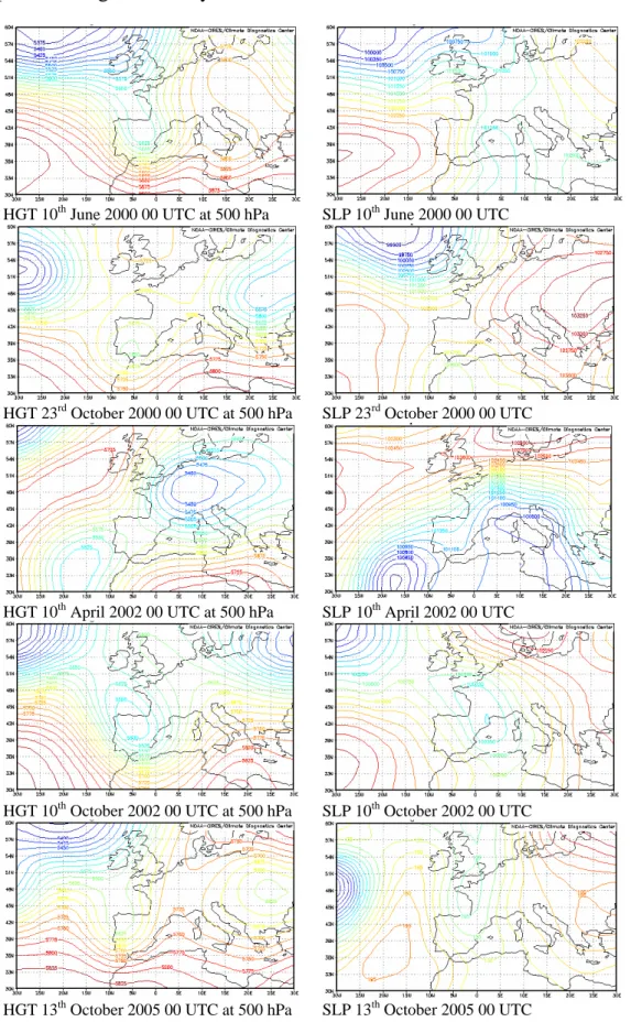
In order to have a better understanding of each event, Figure 3 shows the main synoptic features of each one.
• June 2000
The synoptic situation on 9th June was characterised by the entrance from the western
part of the Iberian Peninsula of a cold front associated with a low situated to the north of the British Islands, while Catalonia itself was under the influence of an anticyclone that affected Central and Eastern Europe also. On 10 June a surface depression was forming over the Balearic Islands while a cold trough could be detected at upper atmospheric levels.
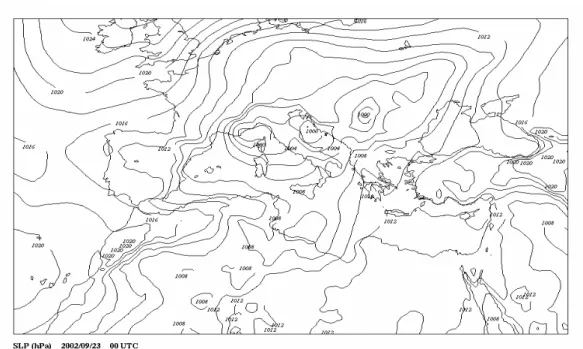
• October 2000
The synoptic situation was characterised by the pass of an important trough moving from West to East of the Iberian Peninsula. Its intensification and strangulation produced the formation of a COL (Cut-Off-Low) above the Gulf of Cádiz. A low was formed over North Africa, as a consequence of the COL formation, producing an important wet, warm and potentially unstable air mass advection from the Mediterranean Sea towards the South of Catalonia. This situation remained during near three days, producing continuous and intense rainfalls over the prior mentioned regions.
• April 2002
The presence of an extended anticyclone from the Scandinavian Peninsula to South Terranova produced the movement toward the Gulf of Cadis of a depression located around Madeira Islands. This configuration implied a southern wet and warm air mass over Catalonia. In the following days, this low was fed by an Eastern/North-eastern cold advection at upper levels, implying the pressure deepening.
On 8th October 12:00 UTC an intense trough associated to an Icelandic low crossed the Iberian Peninsula. Twelve hours after, the Icelandic cold low was divided in two lows and one of them moved to the NE of Spain, forming a COL remaining over it until
12:00 UTC of 10th October. That COL joined with a wet and warm Mediterranean
flow produced high instability in Catalonia.
HGT 10th June 2000 00 UTC at 500 hPa SLP 10th June 2000 00 UTC
HGT 23rd October 2000 00 UTC at 500 hPa SLP 23rd October 2000 00 UTC
HGT 10th April 2002 00 UTC at 500 hPa SLP 10th April 2002 00 UTC
HGT 10th October 2002 00 UTC at 500 hPa SLP 10th October 2002 00 UTC
HGT 13th October 2005 00 UTC at 500 hPa SLP 13th October 2005 00 UTC
Comparison between probabilistic and deterministic models to analyse flash flood events ….
• October 2005
On 12th October a powerful anticyclone was located over Eastern Russia producing a
high pressure blocking. At the same time, a trough was formed in front of the Portugal coast vertical. Due to the blocking made by the high pressure centre, this trough moved towards the South-East, until reached the centre of Iberian Peninsula, in the
form of a very well-defined COL on 14th October.
3.DATABASE AND METHODOLOGY
First of all, a short introduction of the methods used at the present work is presented. That will provide a general overview of the different methodologies applied as well as the database used.
3.1 The MM5 model
The MM5 model is the fifth-generation NCAR / Penn State mesoscale model (Grell et
al., 1994; Dudhia et al., 2005). It is the latest version in a series model that was
developed from a mesoscale model used by Anthes at Penn State in the early 1970's, later documented by Anthes and Warner (1978). Since that time it has undergone many changes designed to broaden its applications. These include: a multiple-nest capability, non-hydrostatic dynamics, and a four-dimensional data assimilation capability (Newtonian nudging), increased number of physics options, and portability to a wider range of computer platforms, including OpenMP and MPI systems.
It is a limited-area, non-hydrostatic, terrain-following, sigma-coordinate model designed to simulate or predict mesoscale atmospheric circulation. The model is supported by several pre- and post-processing programs, which are referred to collectively as the MM5 modelling system. The MM5 modelling system software is mostly written in Fortran, and has been developed at Penn State and NCAR as a community mesoscale model with contributions from users worldwide. The MM5 modelling system software is freely provided and supported by the Mesoscale Prediction Group in the Mesoscale and Microscale Meteorology Division, NCAR (USA).
This numerical model has been run for a 48-72 h simulation period starting on the first day of each event at 00:00 UTC. Three domains connected with two way nesting and having 54, 18, 6 km horizontal grid resolution and 23 vertical levels have been used. The outer domain (domain 1) is centred in the NE Spain at geographical coordinate (39.0ºN, 0.0ºE). Initial and boundary conditions are obtained from the 2.5º resolution NCEP analyses available at 00:00 and 12:00 UTC, which are improved using surface and upper-air observations (ADP, Automated Data Processing observations from the NCEP). Full physics is used and a Betts-Miller scheme (Betts and Miller, 1993) is applied to parameterise convection for the first domain, Kain-Fritsch scheme (Kain and Fritsch, 1993) for the second domain, whereas no convective parameterisation is present over the third domain (Table 1). The convective parameterisation of the third domain is not critical in the study case. Instead of being characterised by a convective pattern, most of the rainfall quantities were recorded in the context of a warm-wet wind advection, triggered by orography. These parameterisations and resolutions have been used with reasonable results in other similar extreme meteorological events in the West Mediterranean area, as for example the cases of November 2001 (Arreola et al., 2003),
June 2000 (Mariani et al., 2005; Romero et al., 2005), September 2002 and November 2002 (Romero et al., 2005), October 2003 (Altava-Ortiz et al., 2006)
Parameterisation D1 (54 km) D2 (18 km) D3 (6 km)
Moisture scheme Reisner 2 Reisner 2 Reisner 2 Cumulus scheme Betts-Miller Kain-Fritsch None
Boundary layer MRF MRF MRF
Atmospheric radiation Cloud Cloud Cloud Soil model 5-layer 5-layer 5-layer
Table 1. Scheme of the parameterisation and domains used in the MM5 simulations. 3.2 The Analogous method
As explained before, the Analogous method takes into account the weather observed in the past associated to certain meteorological variables in surface. When a meteorological situation is forecasted, several past situations are selected by means of the application of some similarity criteria. Since “Two atmospheric states are deemed ‘analogous’ when there is certain resemblance between them” (Lorentz, 1969), it is reasonable expecting similar behaviours on surface for two situations when the weather conditions are analogues.
Different criteria and variables can be selected in order to consider two states as analogous. At the present work, two criteria have been selected. The first one is a “criterion of proximity” in a space of n dimensions (n is related with the number of freedom degrees). The second one is a “criterion of correlation” between variables that characterise an atmospheric state. Only the states that have parameters higher than a prefixed threshold are selected as analogous. After doing the selection, the model outputs are calculated using the meteorological observations associated with the corresponding selected situations.
The “criterion of proximity” takes into account geopotential values at 1000 and 850 hPa levels, which provide a good description of the meteorological state of the atmosphere.
Two domains are involved: Domain 1, which is named the First Selection Window (FSW) and is delimited from 60ºN to 30ºN and from 30ºW to 30ºE. It has a 2.5º grid resolution. This first domain is useful to look for an analogous situation from a synoptic point of view. Due to the fact that heavy rainfall in Catalonia is usually produced by mesoscale processes it would be need to select those days that would have a similar meteorological situation around Catalonia. To get this purpose, a Domain 2 has been made. This domain is the Second Selection Window (SSW) and is centred in Catalonia. It is delimited from 37.5ºN to 45ºN and from 5ºW to 10ºE (Figure 4).
The FSW is an extend area and represents a considerate number of points where data are available. This fact is an advantage in the atmosphere description, but on the other hand, it holds a trouble due to the great number of freedom degrees, falling down the process. To decrease the number of freedom degrees, but trying to maintain a good system description, an EOF process has been performed. The first six Principal Components (PC) keep near 84% of system variance, which is accepted as a reasonable level. Taking each PC as independent from the others, the space which represents the considered meteorological state has six dimensions.
Comparison between probabilistic and deterministic models to analyse flash flood events ….
Figure. 4. Different domains used in the Analogous technique.
Therefore the considered analogous situations are those that lie in the interior of a six-ball of radius d in a 6-dimensional space. The radius is taken as a function of the distance, d, to the origin of the test day, t, as a follows:
(
)
∑
= < − 6 1 j 2 2 1000 tj 1000 ij Z d Z (1)where Zij is the value of the variable Zj on the day i, and Ztj is the variable value on the
forecasted day (test day). To calculate the distance “ d ” the procedure is as follows. Let D be the distance to the origin of the test day, so that:
∑
= = 6 1 i 2 1000 i 2 ) Z ( D (2)The variable D2 follows a distribution law with N degrees of freedom, since Z1, Z2,
ZN are considered independent and identically distributed. For a law of with n degrees
of freedom, the function of density is given by the expression: 2 χ 2 χ
( )
n (n 1)! with , ) ( 2 e x ) x ( f 2 n 2 / n 2 / x 1 ) 2 / n ( − = Γ Γ = − − (3)As the first six PC have been retained, the density function takes the next form: 16 e x ) x ( f 2 / x 2 − = (4)
that corresponds to a Gamma function with parameters (λ=3 and ρ=2). Any quartile of
this function of density has a typical deviation σD proportional to the size of the sample,
m, that is, to the number of analogous situations for each test day. If 30 analogous days are considered then:
30 ) p 1 ( p ) x ( f 1 m ) p 1 ( p ) x ( f 1 D − = − = σ (5)
in which, p is the probability calculated by interpolation based on a table of the Gamma distribution with six degrees of freedom.
For a number of variables between six and eight, Duband (1981) proposes the following expression: 30 ) p 1 ( p ) x ( f 1 d d2=ω2σ2D ⇒ =ω − (6)
in which ω is a parameter that should be increased/decreased if the number of analogous situations are lower than 10 or more than 50.
The “criterion of correlation” is applied to select those days that have high correlation coefficient with the test day. The correlation coefficient used is the linear Pearson’s one and the values to calculate the correlation coefficient are 13 PC: 6 from 1000 hPa, 6 from 850 hPa, and another one at 500 hPa pressure levels. These fields have been selected after testing different levels and taking into account the main factors responsible of flood generation in Catalonia (Gibergans-Báguena et al., 1997; Gibergans-Báguena, 2001).
The vectors containing the values are:
(
500)
6 i 500 2 i 500 1 i 850 6 i 850 2 i 850 1 i 1000 6 i 1000 2 i 1000 1 i , Z , ... , Z ,Z , Z , ... , Z Z , Z ,... , ZZ for each day i
(
500)
6 t 500 2 t 500 1 t 850 6 t 850 2 t 850 1 t 1000 6 t 1000 2 t 1000 1 t , Z , ... , Z ,Z , Z , ... , Z Z , Z , ... , ZZ for the test day.
Candidate days that satisfied the next conditions (Duband, 1981) are selected as analogous ones: 25 . 0 r and 6 r d u 2 2 2 2 = < > (7) It is needed paying attention to those days that have r < 0 (antithesis analogous day). They must be refused previously. The first step in the analogous selection is the application of the explained criteria above the FSW and a certain number of analogous days are selected. Afterwards, a second “criterion of correlation” is applied over the first step outputs, using the SSW. Days best correlated are considered the most similar to the test day. To avoid the possibility of ignoring a similar day in the FSW but with low correlation and high d, the thresholds used in Equation (7) can be relaxed in order to pick up more days.
4.RESULTS
The deterministic MM5 model, as well as the probabilistic one, the Analogous method, provides rainfall outputs in 24 hours and in its own grid resolution. Therefore a different kind of maps for each episode is obtained. Besides this, the MM5 provides an unique output with the total rainfall recorded in a certain time period (in this case, we have selected 24 hours) while the analogous method provides different probabilistic output. Table 2 shows the different probabilistic outputs supplied by the probabilistic method.
ERP(0.5) Expected Rainfall Probability >0.5 mm/day
ERP(2) Expected Rainfall Probability >2mm/day
ERP(10) Expected Rainfall Probability >10 mm/day
ERP(20) Expected Rainfall Probability >20 mm/day
ERP(50) Expected Rainfall Probability >50 mm/day
MER Maximum Expected Rainfall/day
AER Average Expected Rainfall
Table 2. Probability thresholds and outputs obtained by the Analogous technique.
Among all possible combinations between parameterizations and domains, which can be applied in the MM5 model, we have used the physics contained in Table 1. This scheme is not so far from the scheme applied to do daily forecasting, but on the other hand it has been modified following the suggestions from different previous studies regarding extreme events. It would be possible improving results by testing specific
Comparison between probabilistic and deterministic models to analyse flash flood events ….
parameterizations and spatial resolution for each case, but the main idea has been to apply the same parameterization to all the cases and selecting the one that usually works better in all of them.
All maps showed have been obtained using the model reanalysis at 00UTC, with a temporal step of 24 hours. This means the rainfall probability and maximum expected rainfall which are shown in the respective maps, are valid from 00UTC of the considered day to 24 hours later. We have to note this fact, since different temporal steps could yield several probability/rainfall patterns.
Four maps have been selected to illustrate and comparing each case: two corresponding to the Analogous method output (a) and (b), another from the MM5 model (c), and the last one describing the real pattern and amount of rainfall recorded in Catalonia (d).
(a) (b)
(c) (d)
Figure 5. Model outputs for 10th June 2000; (a) Probability of exceeding 50 mm, (b) Maximum expected rainfall, (c) MM5 cumulated precipitation forecast, (d) Observed rainfall field.
On 10th June 2000 the maximum quantity of rainfall was recorded in the central part of
the region (Figure 5d), with values above 200 mm. MM5 output place the maximum rainfall (more than 100 mm) in some central regions as well as in the north coast (Figure 5c). Although the maximum expected rainfall by the Analogous method gives the maximum in the south coast (Figure 5b), the probability of exceeding 50 mm identifies well the second maximum (Figure 5a). However in all cases there is an underestimation of the maximum rainfall.
On 22nd October 2000, rainfall quantities up to 150 mm were registered. Looking the
deterministic MM5 output, values around 60 mm are expected in the same zone as the observed maximum, although this value is clearly under the actual one. Using the output maps of the Analogous method, probabilities of recording more than 50mm in 24 hours are mainly present in pre-littoral zones. The maximum expected rainfall on the contrary, despite of being like the real one, is located in the north.
(a) (b)
(c) (d)
Figure 6. Model outputs for 22nd October 2000; (a) Probability of exceeding 50 mm, (b) Maximum expected rainfall, (c) MM5 cumulated rainfall forecast, (d) Observed rainfall field.
(a) (b)
(c) (d)
Figure 7. Model outputs for 11th April 2002; (a) Probability of exceeding 50 mm, (b) Maximum expected rainfall, (c) MM5 accumulated precipitation forecast, (d) Observed rainfall field.
On 11th April, values of 250 mm were recorded in the North region of Catalonia. The
probability map of more than 50 mm/day, as well as the MER, gives values of 20% and 100 mm near the affected area respectively, although not in the same location. The MM5 model also suggests that maximum values will be in the north, but the in the range of 50÷75 mm.
Comparison between probabilistic and deterministic models to analyse flash flood events ….
(a) (b)
(c) (d)
Figure 8. Model outputs for 9th October 2002; (a) Probability of exceeding 50 mm, (b) Maximum expected rainfall, (c) MM5 accumulated precipitation forecast, (d) Observed rainfall field.
(a) (b)
(c) (d)
Figure 9. Model outputs for 13th October 2005; (a) Probability of exceeding 50 mm, (b) Maximum expected rainfall, (c) MM5 accumulated precipitation forecast, (d) Observed rainfall field.
On 9th October 2002, maximum values were recorded in the central Catalan coast
where near 200 mm were accumulated. According to the MM5, values around 100 mm are expected close to the affected area. On the other side, the Analogous method suggests values of MER near 80 mm all around the central coast.
In this case, the analogous method provides quite good results in the event location, although maxima are below the observed rainfall. The MM5 rainfall pattern is similar to the observed one, but underestimated. Table 3 summarizes previous results.
Analogous method Deterministic method (MM5)
Event Location of maxima Quantity of maxima Location of maxima Quantity of maxima 9-10 /VI/2000 NO NO YES NO 21-23 /X/2000 NO YES YES NO 9-11 /IV/2002 NO NO YES NO 6-18 /X /2002 YES NO YES NO 11-15 /X/2005 YES NO YES NO
Table 3. Summary of the qualitative degree of skill in the rainfall forecasting.
5.CONCLUSIONS
In the present work a probabilistic and a deterministic model rainfall outputs have been compared for five heavy rainfall events that have affected Catalonia.
In general, all cases are underestimated by both techniques but the maximum rainfall location is quite well simulated, especially by the deterministic model.
However, the littoral events are better performed. That is more clearly seen in the case of the Analogous method. These kinds of events are the most common affecting Catalonia, and this fact enhances the capability of the probabilistic model to represent such cases.
When a more detailed study about these cases is carried out, mesoscalar processes are revealed to have an important role in main meteorological features development and generation. This fact is not correctly catch by the Analogous method.
On the other side, since the Analogous method has probabilistic outputs of exceeding a certain threshold, and the events analysed here were extremes, it is not easy to obtain a probability greater than 10-20% for the 50 mm/day rainfall threshold. This is an expectable result given that this quantity is not often reached.
In order to improve the Analogous method, future work contemplates to extend the period of the rainfall database. It theoretically will allow us to have more and more information about extreme events that took place in the past. This is an ambitious goal due to the difficulty of having extended daily precipitation records for a complete region. In addition, using different local criteria to select the cases considered as analogous could get better results.
Concerning the MM5 we hope to get more knowledge about processes generating extreme events in the Mediterranean, so that it would provide better parameterise for the physical relation between variables. The assimilation of real data, which nowadays is already in use, is also expected to improve the model outputs.
Therefore, studying extreme meteorological cases in different ways allows us to get better information about what happened. This kind of studies is included in what has been named as Ensemble Prediction Methods. This technique has been revealed as one of the most powerful to forecast rainfall events.
Comparison between probabilistic and deterministic models to analyse flash flood events ….
Acknowledgements. The authors would like to thank the European INTERREG III-B
AMPHORE project (2003-03-4.3-I-079) and the Spanish RAMSHES project (REN2002-04584-C04) for making possible the development of the present work. The authors also thank Mercè Barnolas and Laura Bota-Moliner for their collaboration and comments in the development of this proceeding.
REFERENCES
Altava-Ortiz, A., A. Barrera, M.C. Llasat, M.A. Prat, J. Gibergans-Bàguena, and M. Barnolas (2006), Application of the MM5 and the analogous method to heavy rainfall event, the case of 16-18 October 2003 in Catalonia (NE Spain), Adv. Geosciences, 7, 313–319.
Anthes, R.A., and T.T. Warner (1978), Development of hydrodynamic models suitable for air pollution and other mesometeorological studies, Monthly Weather Review, 106, 1045-1078. Arreola, J. L., V. Homar, R. Romero, C. Ramis, and S. Alonso (2003), Multiscale numerical
study of the 10–12 November 2001 strong cyclogenesis event in the western Mediterranean,
Proc. of the 4th EGS Plinius Conference on Mediterranean Storms, Alcudia (Spain),
CD-Rom, sec. 1, num. 30.
Barrera, A., M.A. Prat, and M.C. Llasat (2005), Utilización del modelo MM5 para el estudio del episodio de fuertes lluvias y viento de octubre de 2003 en la zona del Empordà (NE Catalunya), Revista del Aficionado a la Meteorología, 36.
Betts, A. K., and J. Miller (1986), A new convective adjustment scheme. Part II: Single column tests using GATE wave, BOMEX, ATEX and Arctic air-mass data sets, Q. J. R. Meteor. Soc.,
112, 693–709.
Brilly, M., and M. Polic (2005), Public perception of flood risks, flood forecasting and mitigation. Nat. Hazard Earth Sys., 5, 345-355.
Ceperuelo, M. and M.C. Llasat (2004), La Precipitación Convectiva en las Cuencas Internas de Catalunya, Revista del Aficionado a la Meteorología, 23 (available in
http://www.meteored.com/ram/numero23/indice.asp).
Delitala, A.M.S (2005), Perception of intense precipitation events by public opinion, Nat.
Hazard Earth Sys., 5, 499–503.
Duband, D. (1981), Prévision spatiale des hauteurs de précipitations journalières, La Houille
Blanche, 7/8.
Dudhia, J., D. Gill, K. Manning, W. Wang, C. Bruyere, S. Kelly, and K. Lackey (2005),
PSU/NCAR Mesoscale modeling system, Tutorial Class Notes and User’s Guide: MM5 Modeling System Version 3 (available in http://www.mmm.ucar.edu/
mm5/documents/tutorial-v3-notes.html).
Gibergans-Báguena, J., M. C. Llasat, and J. Y. Rodríguez (1997), Daily rainfall identification by using an analogous method over local thermodynamic data, Ann. Geophys., European Geophysical Society, C237.
Gibergans-Báguena, J. (2001), Métodos hidrometeorológicos aplicados a la predicción de
precipitación diaria en Catalunya, University of Barcelona, Doctoral Thesis, Internal
Publication.
Grell, G. A., J. Dudhia, and D. R. Stauffer (1994), A description of the fifth-generation Penn State/NCAR mesoscale model (MM5), NCAR Technical Note, NCAR/TN-398+STR.
Homar, V., R. Romero, C. Ramis, and S. Alonso (2002), Numerical study of the October 2000 torrential precipitation event over eastern Spain: Analysis of the synoptic-scale stationarity.
Ann. Geophys., 20, 2047-2066.
Jansà, A. (1997), A General View about Mediterranean Meteorology: Cyclones and Hazardous Weather, Proc. of the INM/WMO International Symposium on Cyclones and Hazardous
Weather in the Mediterranean, Instituto Nacional de Meteorología and Universitat de les Illes
Balears, Palma de Mallorca (Spain), 33-42.
Kain, J. S., and J. M. Fritsch (1993), Convective parameterization for mesoscale models: The Kain-Fritsch scheme, in: The representation of cumulus convection in numerical models, edited by: Emanuel, K. A. and Raymond, D. J., Meteorological Monograph of the American
Meteororological Society, 46, 165–170, 1993.
Llasat, M.C., and M. Puigcerver (1994), Meteorological factors associated with floods in the north-eastern part of the Iberian peninsula, Nat. Hazards, 9, 81-93.
Llasat, M.C. (2001), An objective classification of rainfall events on the basis of their convective features: Application to rainfall intensity in the Northeast of Spain, Int. J. Climatol., 21, 1385-1400.
Llasat, M.C., T. Rigo and M. Barriendos (2003), The ‘Montserrat-2000’ flash-flood event: a comparison with the floods in the North-eastern Iberian Peninsula since the 14th century, Int.
J. Climatol., 23, 453-469.
Llasat, M.C., M. Barnolas, M. Ceperuelo, M. Llasat, and M.A. Prat (2004), Algunos Aspectos Del Impacto Social De Las Inundaciones En Cataluña, Revista del Aficionado a la
Meteorología, 20.
Llasat, M.C. (2004), La Vulnérabilité En Catalogne Et La Perception Sociale, La Houille
Blanche, 6, 71-75, (Ed. SHF), París (France).
Lorentz, E. N.(1969), Atmospheric predictability revealed by naturally occurring analogues, J.
Atmos. Sciences, 26, 636–646.
Mariani, S., M. Casaioli, C. Accadia, M. C. Llasat, F. Pasi, S. Davolio, M. Elementi, G. Ficca, and R. Romero (2005), A limited area model intercomparison on the "Montserrat-2000" flash-flood event using statistical and deterministic methods, Nat. Hazard Earth Sys., 5, 561-581.
Ramis, C., R. Romero, V. Homar, S. Alonso, and M. Alarcón (1998), Diagnosis and numerical simulation of a torrential precipitation event in Catalonia (Spain), Meteorol. Atmos. Phys., 69, 1-21.
Rigo, T., and M.C. Llasat (2005), Radar analysis of the life cycle of Mesoscale Convective Systems during the 10 June event, Nat. Hazard Earth Sys., 5, 1-12.
Romero, R., A. Martín, V. Homar, S. Alonso, and C. Ramis (2005), Predictability of prototype flash flood events in the western Mediterranean under uncertainties of the precursor upper-level disturbance, Adv. Geosciences, 7, 55-63.