CONCENTRATED DEVELOPMENT OF SUBURBAN CITIES IN THE BOSTON METROPOLITAN REGION
by
JENNIFER LEE MARSHALL
Bachelor of Arts, Connecticut College (1987)
Submitted to the
Department of Urban Studies and Planning
in Partial Fulfillment of the Requirements for the Degree of
MASTER OF CITY PLANNING at the
MASSACHUSETTS INSTITUTE OF TECHNOLOGY May 1993
@ Jennifer Lee Marshall
The author hereby grants to MIT permission to reproduce and to thesis document in whole or in part.
Signature of Author
Certified by
2(3
Accepted b.
/
distribute copies of this
Depar ent of Urban Studies and Planning
May 17, 1993
Gary Hack Prpfessor of Urban Studies and Planning Thesis Supervisor
Ralph (qkenheimer Chairperson, Master of City Planning Committee
Department of Urban Studies and Planning
Rotdi
MASSACHUSETTS INSTITUTE OF TECHmNIt
[JUN
0 3 1993
CONCENTRATED DEVELOPMENT OF SUBURBAN CITIES IN THE BOSTON METROPOLITAN REGION
by
JENNIFER LEE MARSHALL
Submitted to the Department of Urban Studies and Planning on May 17, 1993 in partial fulfillment of the requirements for the Degree of Master of City Planning.
ABSTRACT
Over the past two decades a new "sub-urban" form has emerged in suburbs across the nation. These areas contain sprawled out offices, retail malls, industrial parks and car lots, and are often referred to as "edge cities," "urban villages" and "growth centers." Today, there is a concern about these areas and the recognition that something needs to be done to contain this sprawl. Concentrated development is a regional strategy and a physical form that attempts to address the future of our suburbs, as well as the problems of traffic congestion and air pollution. As a strategy, it targets certain areas within a region for development. As a form, it creates a pedestrian-friendly environment with a mix of housing, retail and office uses that are serviced by public transportation. This concept of concentrated development provides a sounding board to envision new suburban
environments.
This thesis attempts to answer the central question - how could concentrated development be achieved? To answer this question, this study examines three suburban areas in the Boston metropolitan area that are prime for concentrated development from a regional perspective. At the local level, the three cases are planning their growth differently. One
- the top-down approach - resisted becoming a concentrated development center. Another - the bottom-up approach - is gearing up to attract and concentrate
development. And the third -the intermunicipal coalition approach - involves two towns that are working together to manage their growth. The study explores the different
methods, processes, approaches, tools and attitudes in the planning process of each case to identify ways that concentrated development could be approached and implemented in the future.
This analysis revealed that subregional planning entities would be needed to envision, manage and govern concentrated development. These entities would first need to be empowered by the state and would consist of public and private representatives from municipalities in and around major growth areas. These entities would most likely be accepted by people at the local level because of a shared interest in the future development of these growth areas, and because individuals would be directly involved in the planning process. This analysis further indicates that regional planners would need to work closely with the representatives in the subregional bodies and people in suburban communities to understand what is important to them about the growth in their communities and to educate them about the benefits of concentrated development.
Thesis Supervisor: Gary Hack
ACKNOWLEDGMENTS
I thank Gary Hack, my thesis advisor, who provided valuable advice on the structure of my thesis and encouraged me to make my own statement. Larry Vale, my reader, listened, guided and challenged me. And Phil Herr, whose honest response to my initial thesis proposal, steered me in the right direction. Thanks also to Lois Craig who guided me throughout the proposal writing process and slipped me many newspaper clippings and references.
I am indebted to everyone I interviewed who took the time out of their day to help me understand the history, issues, challenges, interests and desired outcomes of each of the
cases I studied. Specifically, I would like to thank Terry Szold of Burlington, John Stasik and David Kutner of Framingham, Robert Eisenmenger of Natick, Bernice Mader of Quincy, and Chuck D'Aprix of Quincy 2000 Corporation. I am especially grateful to John Mullin, who not only gave me insight into the Burlington case, but also provided me with wonderful quotes.
I give my special thanks to Donna and William Marshall, my parents, who have always encouraged me to challenge myself and never stop learning. The faith of my two brothers, David and Jonathan, made it possible for me to say, "I think I can, I think I can." I am also grateful to Ruth Corsini, my grandmother and ballet companion, for encouraging me to get my nose out from behind the books now and again during my two years at MIT. Thanks to Pop-pop and Don whose love and support are immeasurable, and who made my education at MIT possible.
I could not have written this thesis without Ian MacArthur whose constant support, even from over 3,000 miles away in Brazil, helped me face and tackle the challenge of this thesis. A big thank you also goes out to Paul Wang who trusted me with his Macintosh PowerBook 140 on my trip to Florida and thereafter. Thank you!
CONTENTS
ABSTRACT ... 2
ACKNOWLEDGMENTS D.G.M.E.N.T... 3
INTRODUCTION ... 5
CHAPTER ONE:
CONCENTRATED DEVELOPMENT: A STRATEGY AND FORM... 9
Benefits Challenges Precedents CHAPTER TWO:
THE BOSTON METROPOLITAN REGION... .. 16
Regional Planning Framework CHAPTER THREE:
THREE SUBURBAN "CITIES" ... 22 Overview
Burlington: The Top-down Approach Quincy: The Bottom-up Approach
Natick/Framingham: The Intermunicipal Coalition Approach Findings
CHAPTER FOUR:
PROSPECTS OF CONCENTRATED DEVELOPMENT ... 60
In the Boston Metropolitan Region In Other States and Metropolitan Regions
Minimal Conditions for Concentrated Development
EPILOGUE...- ..-.-- 77
B I B L IO G R A P H Y ... 78 A P P E N D I C E S ...---...--... 86
Intermodal Surface Transportation Efficiency Act Methods
Interviewees
INTRODUCTION
In his book, Edge City: Life on the New Frontier. Joel Garreau writes that "Edge City puts people on edge. It can give them the creeps." But, he acknowledges, edge cities are a result of us, and our preferences or demands. "I have met the enemy. And he is us." [Garreau 1991: xxii, xxi] Given that our suburbs are rough around the edges, there is a need to reevaluate what we value and what is valuable about our suburban communities, while recognizing the current state of many suburbs.
There has been relatively little regional planning of development in American metropolitan regions over the past fifty years. In the absence of such planning, a sprawling suburban development pattern has emerged since World War II, whereby land uses such as housing, shopping and offices are now dispersed and separated. These sprawled out land use patterns disregard our natural environment and result in higher costs for infrastructure, transportation and public services while consuming more land and energy. [Hanson 1992, Havens 1992, Peiser 1989 ] Linked by a hierarchical road system, these separated land uses have also increased dependence on the automobile. The result of this continuous sprawl "is a relatively low-density, almost uniform network of urbanization moving out over the landscape, punctuated by agglomerations of a much higher intensity and difference in function." [Rowe 1991: 28]
These agglomerations, or regional employment and commercial centers in suburban cities, sprouted in the early-1970s to mid-1980s. As Richard Tustian describes, these areas ". . . have clusters of economic/job linkages, but not social/community linkages. They don't have a physical and design cohesion that fosters a sense of well-being. They sprawl, they're not pedestrian friendly, and they make people use the auto to make connections. They're cities in one dimension only - they have a stomach providing jobs and economic life, but they have no head or heart." [Hamblen 1992: 17] Encouraged by market
pressures, bolstered by major roadways and shaped by low-density land use regulations for single uses, these centers have further uprooted the traditional home/work balance within communities, generated impacts beyond municipal boundaries and created a need for more regional planning. [Hanson 1992, Levine 1990, Weaver 1987]
Today, the timing may be right for more regional planning and the exploration of suburban design alternatives to sprawl. First, there are a number of pressures pushing to reexamine existing suburban development patterns. The quality of life in the suburbs is declining, concerning residents, practitioners and others who want to restore a higher quality of life with more sense of community. Cars and sprawl dominate the suburb, creating what Roberta Feldman and Martin Jaffe call, "a placeless and faceless contemporary American suburb." [Feldman and Jaffe] Suburban traffic congestion has increased, and there is a general distaste for pedestrian-unfriendly suburban malls and office parks - and their
"unsightly" car lots. There is also a growing home/job imbalance whereby housing that is affordable to local residents and jobs that tap the skills of those residents do not match. This home/job imbalance increases the length of the home/work trip, enlarges the area in which people have to live and further adds to the traffic congestion. [Cervero 1989, 1991] Partly due to the rise of telecommunications and cheaper land costs outside of centers, jobs are becoming more decentralized, increasing dependence on the car and making it difficult to support public transportation. In addition, the federal government mandated air quality standards that must be met by violating cities over the next few years. These air quality standards are linked with state transportation plans, requiring each state to prove its transportation plan will improve air quality. 1
1 In 1993, Massachusetts will have to determine a state policy to meet federal air quality standards. In drafting its air quality policy, Massachusetts could examine the opportunities of concentrated
development and look to such state growth management policies as Oregon's that has attempted to make the land use, transportation and air quality connection. A discussion of Oregon's policy follows in
Second, there are a number of opportunities. Many of the suburban centers built in the 1950s and 1960s are beginning to decay and are being rebuilt, allowing for turnover of property ownership. Mixed-use development, including different types of housing, is highly favored by current public policy, and may provide an alternative development form in the reconstruction of these centers. [Urban Land Institute 1991] States are concerned about "transportation catch-up" - the need to focus on transportation infrastructure and "tcatch-up" to changing needs and the burst of development that occurred in the 1970s and
1980s. States are further recognizing that transportation plays a key role in regional economies, and that local municipalities need to be involved in the planning process of transportation alternatives. Recent federal transportation legislation, the Intermodal Surface Transportation Efficiency Act [ISTEA], supports these concerns and acknowledgments.
[see Appendices, p 86] ISTEA, for instance, focuses more on transit than any federal
transportation legislation before, emphasizes local involvement in the planning process, and provides money - comparable to that allocated for highway projects - for both planning and capital projects. There is also a growing awareness that regionalism empowers
localities: localities can collectively make decisions about development that will impact their region, rather than depend on the decision of one community that may benefit from the development. [Gakenheimer et al 1990] And finally, while in a slow economy, there is also the time to plan, identify areas where future development could be invested soundly, and adopt regional strategies that address the possible inequities of focusing development in one area over another.
Third, there are a number of demographic changes. The number of two-income
households keeps rising and job turnover is more frequent, such that a central residential location accessible to many job locations becomes attractive. The population is also getting older, creating a need for different living and community spaces.
The costs of sprawl and the changing times, demand that we evaluate our current
development patterns. Concentrated development - directing resources to form a mixed-use pedestrian-friendly environment that offers a variety of transportation options- can provide an alternative living environment to sprawl while managing our resources and
growth more responsibly. In shaping concentrated development, a larger vision of regional commercial centers is needed. Peter Rowe frames this challenge, "It is only by recognizing the middle landscape as a real locus of growth and innovation in our society, rather than trying to make it in the manner of somewhere else, that progress will be made."
these suburban centers "is going to be about the issues such as civilization, soul, identity, community, the very things that we know and treasure and love about the old cities, and the things we know are absent from the new ones." [Federal Highway Administration 1992: 6]
To be effective, however, concentrated development depends on a regional strategy. But, regional plans are often difficult to implement, especially at the local level. Suburban growth areas that have proven market attraction, such as the three Boston metropolitan suburbs examined in this thesis, provide the opportunity to study ways to approach regional concentrated development - as well as its potential form and how it is governed. Burlington, Natick/Framingham and Quincy each experienced high office and/or retail growth in the 60s through early 80s, responded by restricting development in the mid to late 80s, and are now in the process of planning their future growth more proactively. The different planning approaches in each case represent a spectrum from anti-growth to more pro-growth, and present different opportunities and obstacles for achieving more
concentrated development. Burlington - the top-down approach - resisted becoming more of a regional concentrated development center as suggested by the Boston
metropolitan planning agency, the Metropolitan Area Planning Council and, today is creating its own vision while limiting its regional role. Quincy - the bottom-up approach
- is actively attracting businesses to refocus development within its center. While Natick/Framingham - the intermunicipal coalition approach - recognize they are a growth center and collaborated to "concentrate development" in a triangular commercial area bridging town borders. To manage their future growth, each is also using different planning mechanisms: master plan process; private non-profit corporation; and
intermunicipal overlay district.
Through an analysis of the three areas and their approaches to growth, this thesis attempts to answer: What is being done to redevelop areas that have experienced high growth? How and why? How could some of the methods, processes, approaches, attitudes in the redevelopment process of each case reveal how more concentrated development could be approached and implemented, to meet regional objectives, in the future? And, how does one encourage more concentrated development in the planning process? What may be required of the state and regional bodies?
CHAPTER ONE:
CONCENTRATED DEVELOPMENT: A STRATEGY AND FORM
Concentrated development is both a strategy and a form, offering an alternative to suburban sprawl. Concentrated development is a planning strategy that channels resources to
manage growth within a region. This strategy is accomplished through a comprehensive planning process that specifically examines land use, economics, housing, transportation and design. Certain areas are targeted over others to concentrate development. These areas are nodes of concentrated development: a dense suburban or urban form that attempts to create a "sense of place" by combining a mix of complementary uses, services and housing in a pedestrian-friendly environment that aims to provide other modes of transportation and reduce automobile dependence. Form elements of concentrated development generally include: connecting streets, buildings close to the street, parking on the street and behind buildings, landscaped sidewalks and public spaces, and centrally located transportation stops. To offer alternative modes of transportation and help improve air quality, the concentrated development nodes and central city would ultimately be linked by a regional public transportation system, including transit, express buses and lightrail.
For the purpose of this thesis, concentrated development further implies a land use form that is not fully realized and could be envisioned in suburban areas where there is regional market attraction. Peter Rowe, for example, suggests that to remake this "middle
landscape," or suburban city, there has to be a combination of "extensive realignment and invention:" a balance between pastoralism and modern technology. Such a vision includes a greater respect for the natural environment, the creation of a residential community that reflects changing lifestyles, and a greater mix of uses and services that create a greater sense of public. [Rowe 1991]
BENEFITS
Concentrated development is beneficial for a number of reasons. It serves to:
* Contain sprawl and manage land use development more responsibly and cost-effectively for the region - Concentrated development focuses development in certain areas, and
thereby limits more low-scale, scattered development in other areas that is encouraged today by the lack of land use constraints on urban edges. By concentrating development in an areas, it is also considered a more efficient and more secure way to allocate such
resources as infrastructural moneys. In this way, it is beneficial to both the public and private sectors. It aims to reduce congestion, locate the workforce closer to their jobs and direct infrastructure spending more efficiently, saving tax payers money.
To this extent, concentrated development is considered sustainable, as it contributes to creating a balance between the natural environment and future economic and physical development so that current resources are sustained and not exhausted. This notion of concentrated development as sustainable is supported by such urban and regional thinkers
as Lewis Mumford, Jane Jacobs and Victor Gruen. While each had their own vision of the form and economic and social role of a concentrated development center, collectively they saw concentrated development as the "urban tool" to help remedy some of the human impacts on the natural earth (including consumerism) as well as curb some of the social ills. [Hill 1992] In 1973, Victor Gruen, for example, saw concentrated development as the third form of suburban growth, "Instead of growing, we shall have to learn how to grow up. This implies inner and vertical growth instead of horizontal sprawl." [Hill 1992: 318]
* Raise the quality of life by creating a more mixed use, higher density, pedestrian-friendly
environment with services and housing that is affordable - Such an environment can create a greater "sense of place," and can be more pleasing than the paved parking lots that exist today. With housing that is affordable to employees of suburban regional centers, concentrated development can also provide housing alternatives to the single-family detached home and limit commuting time.
* Reduce the demand for travel and support public transportation - One intent of the form of concentrated development is to create environments that encourage people to use other modes of transportation than their cars, and thereby help to improve air quality and reduce congestion. A mixed use environment that provides a number of services within walking or biking distances of either or both employment centers and residential neighborhoods is one such incentive. Since the facilities are used at different times of the day, a mixed use environment can reduce the amount of parking by sharing parking spaces. [Cervero 1991] In addition, such a suburban form could also curb traffic congestion as much as, or more than, other traffic management methods, since it encourages the use of alternative modes of transportation and creates a steady distribution of traffic rather than having peak "rush hours." [Cervero 1988, 1991] At certain densities, furthermore, concentrated development can ultimately support public transportation.
Establish a development environment in which the developer can build with confidence and environmentalist can be assured other areas will be protected - One concern of developers is having the ability to respond quickly to a "ripe" market, and to have
assurance from a particular community that the regulations will not change. Concentrated development can create an hospitable development environment by establishing a physical area that is more pleasant for businesses, and therefore more attractive to investors, and by demonstrating a commitment from the town/city and region to development in a particular area.
While concentrated development presents an alternative to suburban sprawl, it has some drawbacks that need to be further examined as a strategy and form are developed. For instance, by targeting some areas over others, concentrated development can be inequitable on a regional scale, requiring a distributory system to compensate areas that are not targeted for growth. One such distributory system has been implemented in the Minneapolis-St. Paul region in Minnesota. A percentage (roughly 30%) of the property taxes are pooled and distributed based on residential population. This system, not only provides a method to distribute the "wealth" across the region, it also reduces political competition among municipalities. [Cervero 1991] By skimming off the wealth of the region as a whole and distributing it back to the municipalities within the region, it creates an incentive to make sure the region is doing well, and reduces the need for each township to vie for itself.
Further, while concentrated development may be environmentally sensitive on a regional scale, it can negatively impact natural systems in the immediate area. Concentrated development, in this sense, could be seen as a LULU, a locally unwanted land use. Critical attention has to be paid, therefore, to identifying which areas are the most
environmentally appropriate for concentrated development, and where there may be the best results in working with the community to determine a form of concentrated development.
Concentrated development and its densities may also be considered an urban ill on the landscape to people who have moved to the suburbs to find "a point of equilibrium between the wilderness and urban civilization." [Feldman and Jaffe] Many contemporary suburbs, however, are no longer traditional and have taken on a sprawling, low-scale urban form. While concentrated development is more urban than traditional suburbs or the wilderness, with attention to design, location and "the local fit," it could be shaped into a form that respects the area.
CHALLENGES
Envisioning a new regional approach and form to concentrated development - with both a "head and heart" - raises a number of challenges.
Accommodating the American Dream "to live in the presence of nature; to live near city and country; to own and control our own property; to have constant freedom of movement; to move up; to move away; to start again; to portray our individuality; to cherish our
privacy" [Krieger in Duany and Plater-Zyberk 1991: 11] - It is argued that suburbia emerged as Americans pursued the dream of their own residence, land and later, car -located away from their place of work. Today, this desire for the "American Dream" is augmented by changing lifestyles such as two-income families, job turnover and changing work schedules. The changing lifestyles signal that some preferences may be dissuaded from the "American Dream." However, it is doubtful that the desire for what constitutes the "American Dream" will die. The vision for suburban cities, therefore, must
accommodate "the dream," and provide alternatives to meet the changing lifestyle needs.
* Channeling and tapping market forces that may be in opposition to creating concentrated
development while providing an environment where the private sector can react quickly -Many of the existing market forces discourage concentrated development, and in fact, encourage sprawl. Retail, for example, often requires accessibility, visibility, adequate parking (usually free surface parking and lots of it), and both a tenant mix and project size that meet the market. [Phillips 1989] In many instances, this has been translated into the low-rise "strip mall" or "shopping mall" with over adequate parking. Regional malls especially require a larger draw than the number of people within walking distance from a residential neighborhood, usually meaning access to a major highway. The parking problem is exacerbated by the fact that structured, or multi-tiered, parking (which would reduce the amount of space needed for parking) is expensive and most retail income
generated from the development can not support these costs. By providing free parking for patrons, retail (and office) further encourages car travel and creates unwalkable
disconnected areas - resulting in more sprawl.
Concentrated development further requires a growing economy with a demand for housing, retail and office space. [Cervero 1987] In a relatively slow economy there is little growth today, especially in office development and especially in the Boston metropolitan region. Also, in many suburbs there may not be adequate population to support the uses needed for
a mixed-use environment or a public transportation system. Therefore, development opportunities have to be made clear and secure, and potential markets explored.
9 Gaining local and political support for planning that benefits the region - State and local planning jurisdictions impede regional planning. While the state oversees transportation and other infrastructure decisions, localities generally control zoning and land use. And neither the twain shall meet. Local opposition to regional control of densities, types of uses and other planning mechanisms that are seen as local planning decisions further hinders the regional planning process. In addition, localities are often concerned about their own interests (sound tax base) and not the impact of development on their neighbors, or the region as a whole. And often, regional bodies do not have the legislative power to enforce regional objectives. In general, this lack of power at the regional level and the
unwillingness of the state to empower regional agencies discredits regional planning and acts as a disincentive for local political support. It is important, therefore, to have more empowered regional planning agencies and to include local representation.
- Overcoming local resistance to higher densities - High densities are often associated with urban ills, multi-family or "affordable" housing (i.e. poor people of color), more traffic and negative impacts on the surrounding environment. Meanwhile, the potential benefits of density such as the ability to create a home/work balance, support more of a mixed-use pedestrian-friendly environment that provides daily services, bolster public transportation and reduce the need to drive, and minimize suburban sprawl and thereby conserve open space regionally, are often unknown. To make transit financially feasible, residential density equivalent to 7 housing units per acre, or 2,400-3,700 persons per
square mile would be required. Or an employment density of 50 employees per net employment acre at a minimum of 10,000 jobs (or students) would be necessary, which corresponds to at least an FAR of 2.0. [Cushman in Attoe 1988, Pushkarev and Zupan
1977 in Cervero 1991] Not only does public transportation have a bad name, but these densities are also politically and socially difficult to achieve in suburban areas. Since many suburbs do not have the densities to adequately support public transportation systems, the misperceptions and opportunities of density would have to be addressed through education.
*Balancing individual rights with concentrated development - Concentrated development could favor a few land owners over the many who are able to build in a sprawling
environment. In addition, individual property rights could be sacrificed as land would inevitably have to be assembled to accommodate some of the projects. A series of
mechanisms to address inequities on the regional, municipal as well as individual level would have to be identified.
PRECEDENTS
To begin to meet these challenges, architects and planners have responded over the past decade with a series of design and planning concepts. One such vision of suburban
concentrated development - the so-called "neotraditional approach" - borrows such
elements from early 20th Century towns as "land use mix, density, street patterns, pedestrian circulation, open spaces, architectural character, and sense of community."
[Bookout 1992a: 23] The work of Andres Duany and Elizabeth Plater-Zyberk, and specifically their town of Seaside in Florida, has spearheaded this revival of "town planning." Their concept is generally to reinstate traditional town environments such as Marblehead, Massachusetts through a set of design principles to guide the form of the development and the revision of current zoning ordinances to allow such development to occur. Their work is a resource that could help shape the more traditional components of existing suburbs. However, focused on isolated communities, it generally does not address the larger regional context.
Peter Calthorpe's Pedestrian Pocket, or Transit-Oriented Development (TOD) concept, provides another vision of concentrated development for suburban areas that, with its transportation orientation, is linked to a regional plan. TODs are mixed-use neighborhoods developed around a transit stop and commercial core that attempt to accommodate
pedestrian needs. [Calthorpe 1990] By integrating land-use and transportation planning with urban design, TODs aim to create more walkable commercial and residential
environments with a mix of uses that are economically viable, bridge the job/housing gap while offering more housing that is affordable, support transit lines, and provide a variety of travel choices to ultimately reduce car emissions, and thereby improve the air quality. At varying acreage requirements, TODs could be developed in infill, revitalization and reuse areas or within urban growth boundaries devised to contain development.
As part of the Pedestrian Pocket, there are three concepts that collectively address the different demands in contemporary suburbs and could serve as key models for suburban environments with a growing "split personality." They include: the "Urban TOD," the "Neighborhood TOD" and "Secondary Areas." The Urban TOD is centered around a transit stop for either light rail, subway or express bus and because of its key location contains more of the commercial and job generating uses as well as moderate and high density housing. 2 The Neighborhood TOD is near a transit stop (or possibly in between two), is serviced by buslines, and contains a variety of housing types at different prices, retail and services. Both TODs are surrounded by lower density residential neighborhoods - or Secondary Areas - with public services and amenities that are within a mile of the transit stop. Secondary Areas link surrounding single-family residential neighborhoods with the TODs through a direct roadway system and are more auto-oriented than the Urban or Neighborhood TODs. With its different components accommodating a variety of suburban needs, the TOD concept could be used to illustrate the benefits of density. 3
N.
~ ~ ~ ~ TOD rmtSoLr ~~ ~-.. ALLZBFEEDER BUS LINE
3. Urban and Neighborhood TODs
2 The population that would be housed in the high density housing and the commercial uses around the transit stop are critical in order to justify building the transit and to support the transit once it is built. Coordination of the development of the transit line and the Urban TOD would be vital.
3 Today, this concept is being implemented in Laguna West in Sacramento County, California and is a
component of the accepted regional Land Use and Transportation Air Quality (LUTRAQ) alternative- a linked land use and transportation development pattern presented as an alternative to a proposed Western Bypass freeway around the Portland, Oregon region. LUTRAQ has been recognized and is under consideration by Washington County.
CHAPTER TWO:
THE BOSTON METROPOLITAN REGION
The Boston metropolitan region - an area officially containing 101 towns and cities within a 20 to 25 mile radius of Boston - has to carefully direct new development. Today, there is relatively little population or job growth in the region, limited prospect for development investment compared to the nation because of higher land, energy and labor costs, a saturated office market, little vacant or available land, and a shortage of housing that is affordable to those who work in the area. 4 In addition, strong "home rule," whereby each town and city is autonomous and has a long history of relationships with neighboring localities, makes regional planning difficult. In fact, home rule and property rights are so dominant in the region that Susan Bernstein of Natick claimed, "Planning is like the judicial
system: the rights of the accused supersede those of the accuser." As a result, there is little coordinated regional planning.
The emergence of suburban Boston paralleled national trends of suburban development in the early 20th Century. Initial residential clusters within the Boston metropolitan region grew along streetcar or industrial rail lines, maintaining a strong tie with the central city. As with many cities and regions nationwide, Boston's population peaked in 1950 as
suburbs emerged and people began to move out of the central city. At the same time, major roadways such as Route 128 and the Massachusetts Turnpike were constructed, creating one of the first radial and circumferential roadway systems in the nation. The new
roadways reduced the dependence on rail and allowed development to expand further west.
Freed up by the roadways, suburban development between 1950 and 1970 occurred in two general forms: spread out residential areas and population/commercial clusters along major highways. [Central Transportation Planning Staff 1989, Rowe 1991] Over this period, population increased more dramatically in areas outside Route 128, indicating that areas immediately surrounding Boston were becoming filled and people were moving further out. While population grew only 3% in the 1950s inside Route 128, and actually declined in the 1960s, the population within the entire metropolitan region continued to grow
between 8% and 9% per decade from 1940 to 1970, when it stabilized. 5 [Rowe 1991: 11]
4 While in 1990 the council members of the Urban Land Institute ranked New England as the lowest region in the United States for future development investment, there are industries that are expected to flourish in eastern Massachusetts. These include: eco-industries, bio-research, medical research, communication technology, and cultural tourism.
In addition, the major roadways often bypassed original downtowns to avoid population centers and congestion and to minimize construction costs. [Fortier 1993, Rowe 1991] This phenomenon in part has driven the type and form of development in the regional centers in the 1970s and 1980s, and created a tradeoff between these centers and the
traditional downtowns - which have persisted and continue to persist, possibly due to a
longing for what has been characterized as "New England character."
MPO Commuter Source Area
As the manufacturing base dwindled, computer and telecommunication industries began to move into the region in the 1970s, pulling Massachusetts out of a recession and creating what has been called the "Massachusetts Miracle." [Gakenheimer et al 1990] As a result, the number of jobs in the area, and especially in the suburbs, grew. In fact, nearly 75% of new jobs between 1960 and 1987 located in the suburbs, with more jobs in the areas
surrounding Boston than within Boston by the 1980s. [Central Transportation Planning Staff 1989, Rowe 1991] As a result, low-scale office parks emerged along Route 9, the southern section of Route 128, and especially between the northern part of Route 128 and Route 495, along Route 3. In the 70s and 80s, these centers matured to what they are today, in Jerry Ackerman's words, "Offices are their muscle. . ., but shopping malls are usually their hearts and automobiles their lifeblood." [Ackerman 1991a: A55]
In the region and these suburban centers, however, there is not enough housing that is affordable. The shortage of housing is driven in part by localities that encourage commercial development over housing development - fiscal zoning 6 - in order to generate a stronger tax base and minimize municipal expenses for schools and other services. [Central Transportation Planning Staff 1989] In addition, zoning bylaws restrict multifamily housing, driving up housing costs and forcing housing development and people further away from the downtown. [Cervero 1988] As a result, the commuter shed has expanded [to include as many as 339 municipalities in 5 states, according to the Central Transportation Planning Staff 1989] and the majority [nearly 2/3, according to Cervero] of the work trips are between and within suburbs. To exacerbate this problem, while the population density has increased in Boston metropolitan suburbs, it may not be enough to support public transportation.
Today, due to the radial and circumferential highway system and the way the Boston metropolitan region developed, suburban residential areas and office complexes are spread out and inadequately served by transit, creating greater dependence on the automobile. However, the highway system is overburdened, unable to support the changing
transportation needs and the increasing number of commuters that are having to commute from greater distances. While there is slow growth in the region, and therefore a lack of an
6 Proposition 2 1/2 is a fiscal cap (of 2.5%) on the amount a municipality can increase taxes on existing
property annually. Municipalities are allowed, however, to levy taxes proportional to the amount of increased tax base as a result of new construction or renovation. Since commercial properties usually rate at a higher value and require less expenses than housing, municipalities often zone more commercial areas than residential. Less potential housing in turn has contributed to the rising costs of housing in the region.
engine for change, something has to be done. Targeting suburban centers - areas of anticipated development demand - for more concentrated development is an approach to channel that development and create more livable environments.
REGIONAL PLANNING FRAMEWORK
There are 10 metropolitan planning organizations (MPOs) in Massachusetts and 13 regional planning agencies. Without much legislative power, however, within a state where each locality rules, the MPOs and regional planning agencies act as information clearinghouses. The result is an absence of a coordinated plan for the state as well as the regions.
[Gakenheimer et al 1990] 7 8 While each MPO includes representatives from the Executive Office of Transportation and Construction (EOTC) and the Massachusetts Highway
Department (MHD) and is responsible for devising regional transportation plans, the Boston MPO is especially weighted toward transportation with four of its six agencies reporting to the Secretary of Transportation and Construction. 9 Furthermore, only one of the six agencies provides services to all 101 municipalities in the region. As a result, the Boston MPO is stacked in favor of the state over the region, and there is a division among the members of the Boston MPO whereby four of the members see the state as their constituency while two see the region as theirs. [Kathy Bartolini 1993] To complicate the Boston metropolitan regional structure further, there are also eight subregional
organizations, each with its own bylaw, but with limited power. The MetroWest Growth Management Committee (which will be discussed later in the Natick/Framingham case study) is one of these eight organizations.
7 In response to a concern about "the loss of the unique character of Massachusetts; the need to remove impediments to development and economic opportunity; the absence of coordinated growth policies; the deterioration of resources; and the declining availability of affordable housing," the state established the
Special Commission on Growth and Change in the Commonwealth in 1988. [Gakenheimer et al quoting the Final Report of the Special Commission on Growth and Change in the Commonwealth
1990: 13] Issued in 1990, the Final Report of this Commission called for a state transportation and land
use plan, an enhanced role of MPOs, and local comprehensive plans. The MPOs would establish regional plans that incorporate the local plans and act as a referee to the local disputes. Funding for the Commission was not renewed in 1990 and it lost further support under the current Weld Administration. As a result, the report, according to Kent Stasiowsky of MAPC, is just sitting on the shelf.
8 The Cape Cod (1989) and Martha's Vineyard (1974) Commissions are two county entities in
Massachusetts that were set up by the state to protect the natural character of these areas. While the commissions have been effective, they are not considered metropolitan planning entities, and therefore play a limited role as a model for MPOs in Massachusetts. [Gakenheimer et al 1990]
9 The Executive Office of Transportation and Construction, the Massachusetts Highway Department, the
Massachusetts Port Authority and the Central Planning Transportation Staff report to the State, while the Massachusetts Bay Transportation Authority Advisory Board and the Metropolitan Area Planning Council (MAPC) do not.
The Metropolitan Area Planning Council (MAPC) is the Boston regional planning agency services all 101 municipalities in the region. 10 Without any substantial legislative power, however, the MAPC lacks political support and mainly offers technical assistance to communities for water quality and management, directs state funding for transportation and acts as a conduit of information. According to David Soule, Director of MAPC, "It's sort of like the U.N. We're strictly an advisory board." [Reidy 1993]
Initiated in 1987, MetroPlan 2000 is one of MAPC's undertakings which attempts to address the problems of sprawl in the region by concentrating development. The Plan originally targeted areas with a minimum of 5 million sf of non-residential floor space and required an FAR of 1.5 or greater and a transit and pedestrian-friendly environment with mixed-use development In this initial plan, transit nodes in the sub-regional centers would have been linked by a circumferential transit system of express buses, and eventually, light rail. In 1989, the MAPC indicated 7 areas that were appropriate for such regional growth centers. The Burlington and Natick/Framingham areas were two of the seven recognized.
The original intention of the plan to establish regional concentrated development centers has been weakened. Today, the MetroPlan focuses on existing conditions that could more easily be transformed into concentrated development centers at a smaller scale. Such existing conditions are sketchy and include public transportation services or feasibility to support such services, sewer and water capacity, zoning that allows for concentrated development, and a more pedestrian designed environment that discourages auto travel. However, any one of the 101 communities in the Boston metropolitan area, a subregion or MAPC policy committee can nominate an area to become a concentrated development center. And, once an area is accepted by the MAPC staff, the focus is on the infrastructural needs of the community.
Driving the plan is a concern for the increasing costs of infrastructure, the expected local burden of carrying additional costs, and the need to more efficiently and more
cost-effectively direct infrastructure. The MAPC uses the threat of encouraging or discouraging state infrastructure expenditure as a "limited stick" to encourage communities to comply with the plan.
10 One member from each of the 101 municipalities is elected or designated annually to the MAPC. This member must be a resident or member of the planning board or district commission.
In general, there was resistance to the initial top-down planning of sub-regional
development centers, and there was no "stick" for the MAPC to use to enforce the plan. For instance, at a meeting about the MetroPlan in 1989, the MAPC presented a map of the region with "dots" around areas that could serve as regional concentrated development centers. According to one interviewee, representatives of Burlington, MA responded sharply against being "designated" a regional center and the MAPC removed the dots from the MetroPlan 2000. Over the next few years, other communities such as Peabody, Cambridge and Salem offered to become different kinds of centers, causing the MAPC to shift its approach.
To implement the current MetroPlan 2000, the MAPC is in the process of defining how it will be working with individual (and later multiple) communities and state agencies. The MAPC has initiated a Memorandum of Understanding (MOU) strategy in an attempt to gain cooperation among the various state agencies and support from each community. The strategy is basically a signed agreement among the state agencies with the MAPC and the community to direct resources and funding to the community under the certain conditions of the plan. It is hoped, according to Kent Stasiowsky, that the MOU will give MAPC more authority by more efficiently directing state dollars and coordinating the activities of state agencies. However, to date, the conditions of the plan, what is expected from each community and what role the MAPC will play are not clear. The strategy is currently being tested with Salem, MA.
Thus since its inception in 1987, MetroPlan 2000 evolved from targeting a few large suburban regional centers - areas with the potential for a dense commercial and mixed use core to support transit, to a series of tiered concentrated development centers to serve economic development in the Boston metropolitan area. The FAR is lower than the original plan and there are no specific housing, site or transit requirements, generally allowing any municipality to apply. In addition, there are no guidelines to restrict or designate
concentrated development centers. As a result, the MetroPlan 2000 process has become more political. [Kent Stasiowsky 1993] To this extent, the MetroPlan 2000 is less effective as a regional plan and regional planning effort.
CHAPTER THREE:
THREE SUBURBAN "CITIES"
OVERVIEW
Burlington, Quincy and Natick/Framingham - three suburban cities of the Boston metropolitan region - were selected to study the possibility of achieving more
concentrated development in the region. Each is a suburban center located at intersections of major highways and is attractive to regional demand - and therefore prime for more concentrated development. Each experienced rapid office and retail growth in the 1970s and early 1980s, responded by attempting to restrict development in the mid to late 1980s, and is now engaged in a planning process.
Currently, however, each is approaching its growth differently, such that collectively the cases represent a spectrum from slow-growth to more pro-growth. Burlington is limiting its regional role. Quincy is taking steps to attract development. And, Natick/Framingham recognize they are a growth center and are working together to "concentrate development" in a shared commercial area. In this process, each is using different planning mechanisms to manage their future growth: the master plan process, a private non-profit corporation and an intermunicipal overlay district. Each also represents a different governmental makeup: a town, a city and two towns collaborating.
The cases thus share many characteristics while they are quite different places. By
examining how each is directing its growth and why, the study attempts to identify ways to achieve concentrated development in the region.
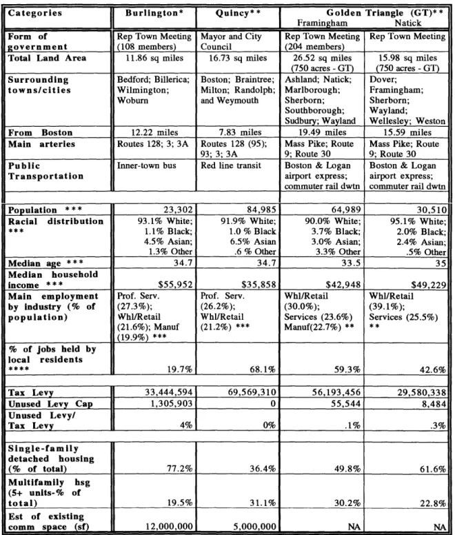
5. Burlington, Quincy, Natick/Framingham and other growing "edge cities"
Categories Burlington* Quincy** Golden Triangle (GT)**
]p I
T
Framingham NatickForm of Rep Town Meeting Mayor and City Rep Town Meeting Rep Town Meeting
government (108 members) Council (204 members)
Total Land Area 11.86 sq miles 16.73 sq miles 26.52 sq miles 15.98 sq miles
(750 acres -GT) (750 acres - GT)
Surrounding Bedford; Billerica; Boston; Braintree; Ashland; Natick; Dover;
towns/cities Wilmington; Milton; Randolph; Marlborough; Framingham;
Woburn and Weymouth Sherborn; Sherborn;
Southborough; Wayland;
Sudbury; Wayland Wellesley; Weston
From Boston 12.22 miles 7.83 miles 19.49 miles 15.59 miles
Main arteries Routes 128; 3; 3A Routes 128 (95); Mass Pike; Route Mass Pike; Route
93; 3; 3A 9; Route 30 9; Route 30
Public Inner-town bus Red line transit Boston & Logan Boston & Logan
Transportation airport express; airport express;
commuter rail dwtn commuter rail dwtn
Population 23,302 84,985 64,989 30,510
Racial distribution 93.1% White; 91.9% White; 90.0% White; 95.1% White;
1.1% Black; 1.0 % Black 3.7% Black; 2.0% Black;
4.5% Asian; 6.5% Asian 3.0% Asian; 2.4% Asian;
1.3% Other .6 % Other 3.3% Other .5% Other
Median age ***34.7 34.7 33.5 35
Median household
income *** $55,952 $35,858 $42,948 $49,229
Main employment Prof. Serv. Prof. Serv. Whl/Retail Whl/Retail
by Industry (% of (27.3%); (26.2%); (30.0%); (39.1%);
population) Whl/Retail Whl/Retail Services (23.6%) Services (25.5%)
(21.6%); Manuf (21.2%) *** Manuf(22.7%) ** ** (19.9%)*** % of jobs held by local residents ****_19.7% 68.1% 59.3% 42.6% Tax Levy 33,444,594 69,569,310 56,193,456 29,580,338
Unused Levy Cap 1,305,903 0 55,544 8,484
Unused Levy/ Tax Levy 4% 0% .1% .3% Single-family detached housing (% of total) 77.2% 36.4% 49.8% 61.6% Multifamily hsg (5+ units-% of total) 19.5% 31.1% 30.2% 22.8% Est of existing comm space (sf) 12,000,000 5,000,000 NA NA
Table 1. Physical and Demographic Profile of the Three Case Studies
* Mostly from Banker & Tradesman - 1992 data
** Mostly from Banker & Tradesman - 1991 data ***' From 1990 Census data
**** From Massachusetts Department of Employment and Training, 1990 data
Sources: Banker & Tradesman, Census 1990, Massachusetts Department of Employment and Training (1990 data), town profiles and interviews.
Categories Bur * Quincy**
1Golden
Triangle (GT)**C a t e g o r i e s B u r l i n g t o n *
_ _ _ _ _ _ _ __
T
F r a m i n g h a m N a t i c kPlanning entities Planning Board Planning Dept GT Steering Comm GT Steering Comm
(# of years) (40+) (40+); City (1988-90) and Sub (1988-90) and Sub
Council; Quincy Conum 92) ; Comm
(1990-2000 Corporation MetroWest (10); 1992); MetroWest
(1/2) Planning Brd (10); Planning Brd
(40+); Planning and Planning Dept
Dept (20)irect ro
Planning positions Dir of Planning Dir, Comm Dev & Dir, Planning; Dir, Planning
Brd Planning; Chrm, Planning Board; Dir.
Chr, Planning Brd; Brd; Planning Brd MetroWest Dir, Quincy 2000 Admin (2 yrs);
_____________Corp (1/2 yr) Dir. MetroWest
Planning vehicle to Master plan Quincy 2000 Highway Overlay Highway Overlay
direct growth Corporation District, for GT District, for GT
Status of planning Completed first Quincy 2000 Adopted the Adopted the
vehic(e and nearly the Corporation Highway Overlay Highway Overlay
second element of incorporated in District - one District
6-part master plan August 1992 element of the
master plan
Status of master Engaged in master No approved Engaged in master No approved
plan plan process; master plan; plan process - master plan
current master plan Quincy 2000 Corp Preparing to
(1965) has initiated an reevaluating base
;advisory
plan zoning regs
Other development Site plan review 6-story height Temporary cap of 30% building
controls/ and subdivision limit; multifamily FAR .32 coverage
limitations control hsg: mAm 2500
sf/unit w/ a min
Masteplan Quinc20042,000/sf per dev
Floor Area Ratio 1 to .25 FAR .5 (resid.) to underlying .5 and No FAR limits;
range and uses (comm. and 3.5 FAR (comm.) .8 FAR limits; GT: GT: .32 with
zoned (in study indust.) .32 with bonuses bonuses up to .4
areas) up to .4 (comm.) to (comm.) No
1 FAR for multifamily hsg
multifamily hsg
Approx. % of total 10% 15-20%
-land vacant or (3 to 4 million sf (mostly in office
available allowed parks)
Current major retail Filenes expansion Shaw's; Stop & Shopper's World Natick Mall (1.2
and office projects (25,000); General Shop (720,000); DJs million sf); Home
(proposed and under Cinema (40,000 );(118,000); Super Quarters (100,000;
construction) (sf) Circuit City Stop & Shop Costco
(70-(29,800) (80,000 ); 80,000); Circuit Walgreens City (40,000) (40,000); Shaws (50-60,000); Bose Hdqtrs -outside the ________________ ____________GT (730,000)
Other relevant Potential 25-35% An upswing of
inormation increase in commer housing
but only 12% in subdivision
(965)housing units, Ini activity.tiaedan
Table 2. Planning Environment of the Three Case Studies
* Mostly from Banker & Tradesman - 1992 data
** Mostly from Banker & Tradesman - 1991 data
BURLINGTON: THE TOP-DOWN APPROACH
Burlington is two towns: a residential community and a regional commercial center. The residential community, predominantly in the north and northwest section of the town, represents Burlington's quality of life image and links it with western suburbs. The commercial hub along Routes 128 and 3 - "an island of urbanity in a suburban community" [John Mullin] - is Burlington's economic life blood and represents its connection with Boston and the region.
Burlington resisted becoming a regional growth center and today, is engaged in a master planning process to shape its future. In the envisioning process, however, Burlington is minimally addressing its existing commercial center and limiting its potential regional role. Guided by the results of a survey sent to residents and business and other public input, the master plan committee has decided to build upon existing community character, businesses and land uses, creating an environment that will allow Burlington to selectively attract high quality businesses in the future. The land use plan highlights a new "Town Center" and specifically provides for research and development activities in areas along Routes 128 and 3. The master plan committee envisions a number of public/private partnerships to direct and oversee key development areas.
BACKGROUND
Until the early 1940s, Burlington was a farming community of 2,500 people with limited commerce. In the early 50s, Routes 128 and 3 were built, making Burlington an attractive location for development. Around 1960, Burlington zoned 1,000 feet north and south of Route 128 for high density commercial/industry use, providing the "go-ahead" for
developers to build manufacturing, research and development and office facilities. 11 From the late 1960s through the 1980s, Burlington experienced significant development (mostly between Route 128 and the new Mall Road) that resulted in a regional mall (with 160 stores and 1.2 million sf of floor space), a national medical clinic and 2 office parks, bringing Burlington's total office space to 3.8 million sf in 52 buildings. [Banker & Tradesman,
1992: 14] During this time, the population nearly doubled from 12,852 in 1960 to 24,374 in 1975, where it has remained relatively stable since, and the town reformed its
government from an open Town Meeting to a representative Town Meeting in 1972.
While Burlington completed a comprehensive master plan in 1965 - which emphasized a systematic approach to control "over-rapid building development to date" [1965 Burlington Master Plan] - and used on-site, off-street parking (with a 25% site coverage
requirement), site plan review and screening bylaw as a package to control development throughout this period, debate still continues today as to how closely the master plan was followed. According to one Planning Board member during this time, the town was "doing all it could just to respond to development applications." [Robert Factor 1993]
By the early 80's, the town had built a Burlington center, which was called "Downtown 128," along Routes 128 and 3 without comprehending the full consequences. As a result, in response to traffic congestion, sewer overflows and water contamination, the planning climate changed from encouraging expansive economic development to restricting growth. The town created the Director of Planning position in 1984 to begin to address its concerns. During the first and second directors' tenures, planning tools such as subdivisions, special permits, zoning by-laws, Floor Area Ratio (FAR) requirements, and planning districts were modified and adopted to control development. Inventory and growth studies were conducted in the mid 80s. Between 1985 and 1987, Burlington instituted a Site Plan and Special Permit Moratorium. [Shaw 1990] In 1986-'87, Burlington adopted the Planned Development District (PDD), a new mixed-use zone which allows members of the Town
Meeting to selectively determine the proportion of uses and density for each proposed project, creating a riskier investment environment. And in 1989, the town downzoned industrial land to .15 FAR from .5 FAR, allowing bonuses up to .25 FAR.
In her piece, "The Quiet Crisis on Route 128," Marybeth Shaw warns that this approach is ultimately destructive. "Worse, the town's 'draconian no-growth measures' (Cervero phrase) manifested in down-zoning and other restrictions promotes continued inefficient, low-density land use with less open space, and increased dependency on private
transportation which, in turn, overburdens the road system." [Shaw 1990: 11]
Today, while remnants of "draconian no-growth measures" remain, Burlington is adopting a more "manage-growth" approach to its own future development - but limiting its potential regional role.
THE ISSUES, PRESSURES AND OPPORTUNITIES
The decay of older industrial areas within Burlington, the threat of lower-class box retail development and continual development activity even in a slow economy, the suggestion by Metropolitan Area Planning Council that the Burlington area become a regional growth center, traffic congestion and the lack of a physical vision provided the impetus for Burlington to engage in a master planning process.
Burlington is most concerned about the blight of industrial land, especially along Blanchard Street south of Route 128, and the long-term consequences of vacancies, and is trying to determine whether municipal actions towards investment on public or private lands will have the strongest impact in creating a strong Burlington. [Terry Szold 1993] In addition, competition from office complexes in neighboring towns and cities, especially Waltham,
and a slow economy have created a tentative business climate with high vacancy rates (21% in 1991) and decreasing rents (down to $16-18/sf in 1991 from $21-23/sf in 1985).
[Banker & Tradesman 1992: 12] To remain competitive, land owners have had to offer lower rents, free rent and tenant space improvements. [Banker & Tradesman 1992: 12] Given these pressures, Burlington needs to, in Jack Kelly's words, "guard against becoming a slum."
In the future, it is expected that there will be an increase in the "demand for professional and technical work" in the region [Burlington MP Committee with Mullin Assoc. 1993: 2] and that Burlington has the option to "attract more retail, service, software and medical related jobs." [Burlington MP Committee with Mullin Assoc. 1993:3] Burlington has the capacity to absorb this demand. Under existing zoning, Burlington is only 65-75% built-out, allowing for an additional 3 to 4 million sf of commercial and industrial space.
However, since these service-base jobs require less space per worker, there is the potential for more employees coming to Burlington. Also, as part of this trend, industries are clustering, downsizing and creating linkages with other supporting services, which would require more mixed-use zoning than exists. Given existing road conditions, public
transportation options and current low-density single-use land use controls, this could lead to increased traffic congestion. This is especially exacerbated by the fact that Burlington currently imports 80.3% of its workforce, a high percentage compared to similar areas in the region.
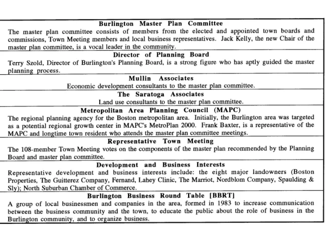
Burlington Master Plan Committee
The master plan committee consists of members from the elected and appointed town boards and
commissions, Town Meeting members and local business representatives. Jack Kelly, the new Chair of the master plan committee, is a vocal leader in the community.
Director of Planning Board
Terry Szold, Director of Burlington's Planning Board, is a strong figure who has aptly guided the master planning process.
Mullin Associates
Economic development consultants to the master plan committee.
The Saratoga Associates
Land use consultants to the master plan committee. Metropolitan Area Planning Council (MAPC
The regional planning agency for the Boston metropolitan area. Initially, the Burlington area was targeted as a potential regional growth center in MAPC's MetroPlan 2000. Frank Baxter, is a representative of the MAPC and longtime town resident who attends the master plan committee meetings.
Representative Town Meeting
The 108-member Town Meeting votes on the components of the master plan recommended by the Planning
Board and master plan committee.
Development and Business Interests
Representative development and business interests include: the eight major landowners (Boston Properties, The Guitterez Company, Fernand, Lahey Clinic, The Marriot, Nordblom Company, Spaulding & Sly); North Suburban Chamber of Commerce.
Burlington Business Round Table [BBRT]
A group of local businessmen and companies in the area, formed in 1983 to increase communication between the business community and the town, to educate the public about the role of business in the
Burlington community, and to organize business.
Table 3. Key Players and Interested Parties in Burlington