HAL Id: halshs-02361382
https://halshs.archives-ouvertes.fr/halshs-02361382
Submitted on 12 Dec 2019
HAL is a multi-disciplinary open access
archive for the deposit and dissemination of
sci-entific research documents, whether they are
pub-lished or not. The documents may come from
teaching and research institutions in France or
abroad, or from public or private research centers.
L’archive ouverte pluridisciplinaire HAL, est
destinée au dépôt et à la diffusion de documents
scientifiques de niveau recherche, publiés ou non,
émanant des établissements d’enseignement et de
recherche français ou étrangers, des laboratoires
publics ou privés.
Building the Empire. Settlement Patterns in the Middle
Assyrian Empire
Aline Tenu
To cite this version:
Aline Tenu. Building the Empire. Settlement Patterns in the Middle Assyrian Empire. Understanding
Hegemonic Practices of the Early Assyrian Empire. Essays dedicated to Frans Wiggermann, 2015.
�halshs-02361382�
www.nino-leiden.nl
This pdf is a digital offprint of your contribution in
Understanding Hegemonic Practices of the
Early Assyrian Empire. Essays dedicated to Frans
Wiggermann. Edited by Bleda S. Düring.
PIHANS, vol. 125;
ISBN: 978-90-6258-336-2.
www.nino-leiden.nl/publication/understanding-hegemonic-practices-of-the-early-assyrian-empire
The copyright on this publication belongs to the publisher,
the Netherlands Institute for the Near East (Leiden).
As author you are licensed to make up to 50 paper prints
from it, or to send the unaltered pdf file to up to 50 relations.
You may not publish this pdf on the World Wide Web –
including websites such as Academia.edu and open-access
repositories – until three years from publication (January
2015). Please ensure that anyone receiving an offprint
from you, observes these rules as well.
For any queries about offprints and copyright,
please contact the editorial department at the
Netherlands Institute for the Near East:
UNderStANdINg HegeMoNIC PrACtICeS
oF tHe eArly ASSyrIAN eMPIre
eSSAyS dedICAted to FrANS WIggerMANN
edited by
bleda S. d
üringNederlANdS INStItUUt voor Het NAbIje ooSteN
leIdeN
Table of contents
Introduction . . . 1
Bleda Düring
I. Mittanians and Middle Assyrians
1. Making Mittani Assyrian . . . 9
Rafał Koliński
2. the rise and Consolidation of Assyrian Control on the Northwestern territories . . . 33
Anacleto D’Agostino
II. Middle Assyrian Landscapes and Settlements
3. Middle Assyrian territorial Practices in the region of Ashur . . . . 45
Simone Mühl
4. Core and Periphery in the Assyrian State: The View from Dūr-Katlimmu. . . . 59
Hartmut Kühne
5. building the empire: Settlement Patterns in the Middle Assyrian empire. . . . 75
Aline Tenu
III. The Western Periphery
6. West of Aššur: the life and times of the Middle Assyrian Dunnu at tell Sabi Abyad . . 89
Peter M. M. G. Akkermans and Frans A. M. Wiggermann
7. the Pots of Assur in the land of Hanigalbat – the organization of Pottery
Production in the Far West of the Middle Assyrian empire . . . . 125
Kim Duistermaat
8. the Central building of the tell Sabi Abyad Dunnu . . . . 153
Victor Klinkenberg and Tijm Lanjouw
9. daily life in the Wild West of Assyria . . . . 177
Stefan Jakob
IV. Feeding the Empire
10. Middle Assyrian Herding Practices in the North of the empire:
A view from Dunnu-ša-Uzibi . . . . 189
Rémi Berthon
11. Middle Assyrian Agrarian Management in the West in the light of its Forerunners . . 199
Hervé Reculeau
12. Agriculture on the Fringe: reconsidering the role of barley in Middle Assyrian
Agriculture . . . . 221
Federica Fantone
V. Middle Assyrian Administrative Practices
13. dynastic Marriages in Assyria during the late Second Millenium bC . . . . 235
Daisuke Shibata
14. Foreign Kings in the Middle Assyrian Archival documentation . . . . 243
Jaume Llop-Raduà
15. government recording Practices in Assyria and her Neighbours and Contemporaries . 275
J. Nicholas Postgate
VI. Understanding Assyrian Imperialism
16. Power, Hegemony, and the Use of Force in the Neo-Assyrian empire . . . . 287
Bradley Parker
17. the Hegemonic Practices of the Middle Assyrian empire in Context. . . . 299
5.
Building the Empire
Settlement Patterns in the Middle Assyrian Empire
Aline Tenu
CNRS, Maison René-Ginouvès, Nanterre
The creation of a territorial state by the Assyrians from the middle of the 14th century BC onwards
has been an undeniable success in its political, military, and geographic dimensions. The territorial structure of the Middle Assyrian state has been a long-standing issue mainly discussed on the basis of two different models of control and dominion: that of the ‘network’ (Liverani 1984); and that of the ‘oil stain’ (Postgate 1992), and the accuracy of the term ‘empire’ to characterize the Middle Assyrian State is also still much debated (see Kühne, this volume).
I (see also Tenu 2009: 25-7) subscribe to the definition given by Carla Sinopoli (1994: 160) who conceives an empire as an: ‘expansive and incorporative kind of state, involving relationships in which one state exercises control over other socio-political entities (e.g. states, chiefdoms, non-stratified societies)’, and imperialism as: ‘the process of creating and maintaining empires’, even if as Frédéric Hurlet (2011: 133) reminds us:
“L’empire est une notion qui apparaît familière aux historiens, mais qui se dérobe très vite
dès qu’il faut s’entendre sur une definition minimale valable pour les innombrables experiences impériales qu’a connues l’histoire universelle”.
Data stemming from new excavations, mostly in Syria, on the one hand, and from recent cuneiform text publications on the other, shed new light on the Middle Assyrian state. These new data facilitate a more precise synthesis of the settlement patterns and the spatial organization of the Middle Assyrian state.
The aim of this paper is to address the hegemonic practices of the Assyrian state, and in particular their territorial aspects, and to provide new elements to augment existing models in order to understand how the Assyrians controlled and ruled the various territories they conquered, and to what extent they adapted to local situations. First I will analyze how the Assyrians integrated or disregarded the preexisting Mittani period settlement systems when they became the sole masters of North Mesopotamia. Subsequently I will consider the role and importance of new settlements intended to replace and alter the pre-existing urban system. Finally I will examine the role of new small settlements, whether they were fortified or not.
5.1 The Mittani Legacy
When the Assyrians conquered North Mesopotamia they inherited the settlement system of the preceding Mittani state. We can ask to what extent they maintained or altered this settlement system. This question involves what are actually two separate issues: first, did the Assyrians continue occupying Mittani sites; and, second, if so, did they maintain their settlement hierarchy. Answering these questions is not an easy task for various reasons.
First archaeological documentation is scarce and uneven. Assyrian pottery of the last part
of the 14th century BC and of the first part one of the 13th century BC remains widely unknown.
The transition between Mittani and Middle Assyrian levels is, in fact, not always discernible (Duistermaat, this volume). This confusion is aggravated by the poor knowledge we still have of the Mittani common ware despite Pfälzner’s important work (1995). Moreover most sites have been excavated only over a rather limited area and accordingly it is often not possible to deduce much from the archaeological results about the nature of occupation with such limited exposures. Therefore, we should also take into account epigraphic data, in order to try and obtain a better understanding of the way in which the Assyrians assimilated or transformed the Mittani legacy.
However, this attempt is seriously hampered by the fact that the central records of the Mittani state have not been found so far. The administration and territorial organization of the Mittani state is thus very poorly known, and mainly through indirect sources. In addition, sites that have been archaeologically investigated are not always also documented in written records. Conversely, the texts mention numerous cities ruled by a bēl pāhete which we have not been able to localise, so comparisons between archaeological and written data are often not possible.
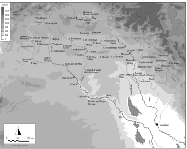
Despite these problems, various known elements do allow us to address how at least a part of the Mittani legacy was incorporated into the Assyrian urban network. One element consists of the major cities of Taidu and Waššuganni (figure 5.1), the two capitals, as well as the other towns quoted in the Adad-nārārī I’s annals: Amaṣaki, Kahat, Šuru, Nabula, Hurra and Šuduhu (Grayson 1987: 136 (RIMA 1, A.0. 76.3, 26-30)).
The question is whether they remained occupied or were deserted after the Assyrian conquest, and whether these urban settlements maintained their former privileged status in the new administrative network. To answer these questions we need to compare Mittani and Middle Assyrian levels of sites that can be identified with those mentioned in the texts. As mentioned, only a few sites can be firmly identified, and among these the capitals do not figure.
Figure 5.1: Northern Mesopotamia in the Middle Assyrian period.
The location of Taidu continues to be the subject of much debate. The identification with Tell al-Hamidiye, proposed in 1980’s by Haas and Wäfler (1985: 69), has recently been
reinforced by the discovery of written documents studied by Kessler (presentation at 55e RAI,
July, 7th 2009, Paris) who considers this hypothesis highly probable. Archaeological data may
further support this hypothesis, because an important building, interpreted as a palace, has been
A. TENU 76
excavated in part on the top of the high mound. This building was occupied continuously from the Mittani to the Middle Assyrian periods (Eichler et al. 1990: 241-54; Eichler and Wäfler 1989-1990: 249-50). The other identification of Taidu is with Üçtepe, which was also proposed by Kessler (Kessler 1980: 119). At these sites, Mittani, Middle, and Neo-Assyrian levels have been excavated (Sevin 1989: 106-7; Eichler et al. 1990: 241; Tenu 2009: 216), but their chronology is not well known. So the extant archaeological data cannot really help resolve the problem of the identification of Üçtepe.
For Waššuganni the ‘historical’ candidate is Tell Fekheriye. This hypothesis has been much discussed, especially because until recently traces of the Mittani occupation were rather limited. Excavations conducted by Dominik Bonatz since 2005 have changed our understanding of the site. Mittani architectural structures have been excavated especially in Area C (http://www.fecheriye.de), and new petrographic analysis of the Tell el-Amarna tablets confirm they are made of clay from an area with geological properties similar to those near Tell Fekheriye (Bonatz et al. 2008: 92). In addition a recently discovered very fragmentary tablet may give a new hint to support the identification (Bonatz et al. 2008: 130-31). Middle Assyrian tablets found in 2009 and 2010, dated to the reign of Shalmaneser I, confirm the role of the city in the Assyrian administrative network (www.fecheriye.de).
Similar issues pertain to other cities mentioned in annals: Amaṣaki, Kahat, Šuru, Nabula,
Hurra and Šuduhu. Only two of them are more or less securely localized: Nabula and Kahat.
Nabula has been identified with Girnavaz and was briefly excavated by Hayat Erkanal in the 1980s. Middle Assyrian layers and a Middle Assyrian tablet dated to the reign of Tiglath-pileser I have been found there (Erkanal 1989: 261), but the publication of this text is not available.
Kahat is to be located at Tell Barri. This site has yielded several Mittani levels separated from the Middle Assyrian occupation by a hiatus (Pecorella 1994: 7; 1998). A large corpus of Middle Assyrian pottery (Anastasio 1998, D’Agostino, this volume) as well as Middle Assyrian tablets (Salvini 1998; 2004; 2005) were found.
Thus, in so far as we have archaeological documentation of these important Mittani cities, they continue to be occupied after the Assyrian conquest, and to my knowledge traces of violent destruction were not discovered on any of them.
The second point is assess archaeological data to investigate whether the royal cities retained a significant position in the new administrative structure. Texts discovered in Aššur indicate that Taidu (Jakob 2003: 116) and Waššuganni (Freydank 2006: 13; Freydank and Feller 2007: 13) became provincial capitals, and were thus integrated into the new Assyrian provincial administration.
Generally speaking, we can observe the same ‘fate’ for other cities. Bēl pāhete are attested at Ahurra, Amaṣaki as well as at Šuduhu (Jakob 2003: 112-6). Amaṣaki and Šuduhu are also quoted in lists of (regular) gina’u offerings to the temple of Aššur dated to the reigns of Enlil-kuduri-uṣur (Freydank 2006: 15) and Tiglath-pileser I (Postgate 1985: 96). Nabula appears also in an administrative text of Aššur dated to the reign of Tukultī-Ninurta I (Freydank 1994: 12) and pertaining to the gina’u offerings in Aššur, but the status of the city is not clear. This trend, of transforming previous royal cities into provincial capitals, has two important exceptions: Kahat, which does not appear in textual sources after the destruction of Mittani; and Šuru. The latter city is probably mentioned in texts from Tell Amuda published by Aynard and Durand (1980: 46-7) but no longer in the central record of Assyria. It perhaps lost its privileged status even if it was still occupied.
Secondary sites are also known. Tell Brak, Tell Mohammed Diyab, Tell Hammam et-Turkman for instance were occupied both in the Mittani and in the Middle Assyrian periods. Archaeologists observed a gap of occupation after the Assyrian conquest, which was accompanied by destructions at Tell Brak (Oates 1990; Oates et al. 1997) and Tell Mohammed Diyab (Sauvage 1997). Both were subsequently reoccupied after a hiatus. At Tell Hammam et-Turkman the situation is different: the palace was deliberately abandoned after being completely emptied.
Eventually the abandonment was longer than expected and the inhabitants had to erect a new building (Meijer 1988).
Two other sites warrant discussion. Tell Chuera (ancient Harbe) was a seat of an Assyrian province at least in the 13th century.1 Two Mittani buildings (Knicksachstempel and Mittani-Bau)
were excavated by Anton Moortgat (Moortgat 1962: 17-22; Moortgat and Moortgat-Correns 1976: 35-68) and the name of the site appears in a text from Alalah (Belmonte Marín 2001: 117). Tell Chuera is occupied during both periods but we do not have any data concerning the actual continuity between them (see also Jakob, this volume). The second site, Nahur, a Mittani city situated near the Habur sources, has been sacked by Adad-nārārī I (Grayson 1987: 159-60 (RIMA 1, A.0. 76.25)), and became the center of a province at least in the 13th century BC (Kupper 1998:
86-7; Jakob 2003: 115) but unfortunately no mention to the status of the city in the Mittani empire is made in the Assyrian inscription.
Finally we may also consider the situation of the smallest sites and villages, even if the data are rather scant. A very small number of villages have been excavated and in surveys Mittani
and Middle Assyrian pottery are often discussed together.2 Given that only a very small number
of surveys deal with Mittani and Middle Assyrian pottery separately, changes in settlement patterns are difficult to assess. There is however a general trend toward a reduction of the number of sites. In the Balikh Valley, 80% of sites were abandoned after the Mittani period (Lyon 2000: 224-5), and in the Habur area, small rural sites were deserted, and replaced by larger settlements less numerous (Pfälzner 1995: 225). Daniele Morandi Bonacossi however demonstrated that even if the number of sites declines from the Mittani to the Middle Assyrian period (from 24 to 9), the population in the Habur Valley might have increased (Morandi Bonacossi 2008: 198-9, see also Abb. 12:6 and 12:7). Northern Mesopotamia was thus less densely occupied, even if perhaps more populated than before.
In addition to the limited corpus of data available, another important limitation complicates the analysis of the transition from the Mittani to the Middle Assyrian period. Our reconstructions rely mainly on the presence of the Middle Assyrian pottery assemblage as defined by Pfälzner (1995), but the corpus of the first part of the Middle Assyrian domination is still unknown and one may discuss if we are able to correctly assign to the Middle Assyrian period all the material used in the Empire (Tenu 2007; 2013: 567-9; also Duistermaat, this volume).
Putting aside all these reservations, a general tendency comes to the fore: the fate of the Mittani sites might have depended on their importance: villages were abandoned for the benefit of larger cities, and ancient urban centres kept a significant administrative place in the new network. Provincial capitals have strong continuities with the preceding Mittani administrative system, and might have been modelled after older administrative divisions. The territorial organization was not re-engineered, and this might have been the most efficient for exploiting these territories and to recover from ravages of war.
5.2 New Creations
The Mittani urban structure, partly kept, was complemented by new foundations. The most famous is Kār-Tukultī-Ninurta. Due to the low number of campaigns undertaken at the site, the town planning is still only partially known, but German archaeologists found at least a palace finely decorated with wall paintings and a temple dedicated to the god Aššur (Eickhoff 1985). The presence of this temple is in itself very significant because even in Kalhu or in Nineveh in the first Millennium no temple to Aššur was ever erected. This temple was to remain in the city of Aššur.
1 Texts from Tell Chuera have been published firstly by Cord Kühne (1995). A new edition has been recently
made by Stefan Jakob (2008).
2 This is for instance the case of the recent survey conducted by Mark Altaweel in the Iraqi Jazira. Mittanian
material was not diagnostic enough to be mentioned separately (Altaweel 2006: 157; 2007: 118).
A. TENU
The fact that Tukultī-Ninurta I built such a temple in his new city may betray an actual desire to abandon nearby Aššur and to settle there.
Various scholars have stressed the importance of the foundation of an imperial capital in the consolidation of empires, eg.: as ‘an affirmation of power and charismatic identity by a specific ruler’ (Matthews 2003: 135). The ideological aspects of this creation are so predominant that we cannot easily understand what the role of this city might have been in the general administrative system of the state, even if bēl pāhete are attested (Jakob 2003: 114). One of the most important advances of the excavations conducted by Reinhard Dittmann in the 1980s, was that Kār-Tukultī-Ninurta was not abandoned after its founder’s tragic death but remained occupied until the Neo Assyrian period (Dittmann 1990; Bastert and Dittmann 1995).
For various reasons, Kār-Tukultī-Ninurta is the most well-known of the royal creations, but it is not the only city founded by a king in the Middle Assyrian period. That Tukultī-Ninurta’s father preceded him with the erection of Kalhu we learn only through the Annals of Aššurnaṣirpal II (Grayson 1991: 227 (RIMA 2, A.0. 101.2)). The archaeological remains of the Middle Assyrian occupation are very scant (see Tenu 2009: 91 with bibliography), and from an archaeological point of view, evidence is too limited to infer a possible ‘royal’ status of the city, but in texts Kalhu seems to be a town like any other, even if it was a provincial capital of some importance (Postgate and Reade 1980: 320). Why did Shalmaneser I build a new city in this area? Although, he never mentioned this foundation among his own achievements, this creation was maybe not a matter of prestige, but might have been linked to geostrategic or economic needs.
The other important site we may think about is Dūr-Katlimmu (modern Tell Sheikh Hamad). The city was not in itself a true ‘new creation’ because a Mittani occupation has been found in the sector of the Building P Room C (Kühne 1990: 157). However, even if remains from the Mittani period are documented, it is clear that the city became far more important in the Middle Assyrian time than before, when chosen by Shalmaneser I to be the seat of the Grand Vizier, King of Hanigalbat.3 The city was ruled by a bēl pāhete (Jakob 2003: 113), but its place in
the administrative structure of the Empire is far more significant, because it controlled the western part of the Empire.
Beside these city creations, which may have been exceptional, we also have many instances of ‘normal’ new sites. In tablets there appear a lot of new toponyms, which were probably integrated in the Assyrian administration. However, because their location is often unknown, we cannot establish whether they designate new towns or whether they are only new names for already existent settlements.
Although we have limited information to study the administrative division of the previous Mittani core region, new settlements seem rather rare there. The best example of a new foundation is certainly Tell Amuda, where archaeological and textual data provide a similar picture. The name of the site, Kulišhinaš, is not attested in the Mittani documentation, and no level prior to the Middle Assyrian period has been found there (Bunnens and Roobaert-Bunnens 1988; Faivre 1992). The thickness of the Middle Assyrian deposits as well as the discovery of large walls belonging to substantial buildings confirm the importance of this city which was a provincial capital.4 This case is almost unique, and Daisuke Shibata (2012: 496), on the basis of a text found
at Tell Taban, has now expressed doubts concerning the identification of Kulišhinaš with Tell
3 The literature concerning the place of Dūr-Katlimmu in the Assyrian Empire is too vast to be wholly
quoted: see inter alia Cancik-Kirschbaum (1996; 2000), and H. Kühne (1994; 1995; 2000; 2009; 2013; this volume).
4 Texts supposedly from Kulišhinaš have been published by Aynard and Durand (1980) and by Machinist
(1982). Its name is mentioned in different administrative texts from Aššur and Kār-Tukultī-Ninurta (Weidner 1935-1936: 41; Freydank 1982: 26; 2001: 26; 2004: 15; 2005: 13; 2006: 15; Freydank and Feller 2010: 13; Prechel and Freydank 2011: 13).
Amuda. Thus data pertaining to new cities erected to be provincial capitals is rather meagre, and we may wonder in what extent Kalhu constitutes a special case. It is also possible that this observation, that we have little evidence for new provincial capitals, is a function of the nature of written and archaeological sources which do not facilitate comparisons.
5.3 Small (fortified) Sites and Dunnus
Beside major cities, villages and smaller sites – sometimes fortified – were also founded and even if they were maybe far less important in the administrative fabric they however had a significant role to play in the control of territory. These settlements present differences in their shape, in their location but also in their functions. Some belong to the administrative category of dunnu. The best known is Tell Sabi Abyad, which was strongly fortified: a large wall defended the top of the tell, where a tower stood (Akkermans 2006: 203; Akkermans and Wiggermann, this volume). However, as Andreas Schachner has recently recalled after the excavations at Giricano the term
dunnu designated only an administrative class, which cannot be associated with a special kind of
settlement (Schachner 2004: 5). Some were mainly devoted to agricultural production: Tell Sabi Abyad according to Frans Wiggermann (2000: 172); or Giricano (ancient Dunnu-ša-Uzibi) where important pits intended for crops storage were excavated (Schachner 2002; 2004). Other small settlements were rather outposts controlling margins or roads.
The most well-known road station is Tell Umm Aqrebe, a site discovered during the Wadi
Agig Survey in the 1980s. No excavations took place after this first reconnaissance so the actual
shape and town planning of the site remain unclear, but the significant quantity of pottery as well as its typology combined with its location indicate that it was very likely a road station on the route between Aššur and Dūr Katlimmu. The existence of similar sites evenly spaced out along the road has been assumed by Reinhard Bernbeck and Peter Pfälzner (1994) from the original idea of Hartmut Kühne published in the Festschrift Bittel in 1983. Recently we proposed with Juan Luis Montero Fenollós and Francisco Caramelo (Tenu et al., in press) the route continued towards west to Tuttul, Tell Fray and Emar via Qabr Abu al-‘Atiq. The latter site has first been identified by Berthold Einwag, Kai Kohlmeyer and Adelheid Otto in the 1990s (1995: 102). It has been excavated between 2008 and 2010 by a team led by Juan Luis Montero Fenollós (Montero Fenollós et al. 2009; 2010; 2011). The Middle Assyrian building has been discovered on the top of a small hill more than 3 m high, measuring 58 m x 45 m. Only 5 rooms have been partly unearthed, they have yielded the complete Middle Assyrian ‘official’ assemblage and two tablets,
one of which dated to Abattu son of Adad-šumu-lēšir: the eponym the 11th year of
Tukultī-Ninurta I. The building has been violently destroyed by a fire after this date. Because of the limited size of the settlement which is reminiscent of the dunnu of Tell Sabi Abyad (ca. 60 m x 60 m) and of the dimensions of the rooms which are very similar to those of the Building P of Dūr-Katlimmu, Montero Fenollós proposed Tell Qabr Abu al-‘Atiq may have been a dunnu built and owned by a high ranking official of Dur Katlimmu (Montero Fenollós et al. 2011: 270; Tenu
et al. 2012: 148). Several dunnu (Tell Sabi Abyad and Dunnu-Aššur for instance)5 were given by
the king to his dignitaries certainly to increase their revenues, and to secure and reward their loyalty. Directly after the conquest of the Upper Tigris Valley, a man called Uzibi received from Shalmaneser I a dunnu which was named after him (Dunnu-ša-Uzibi) (Radner 2004: 70-1). Agricultural land management seems to be the main activity of the dunnu, but the location of Tell Qabr Abu al-‘Atiq in an area ill-suited for farming might suggest that dunnu could also have been erected solely for military or security reasons.
The quadrangular fortress of Haradu (modern Khirbet ed-Diniyeh), explored by Christine Kepinski between 1981 and 1985, differs considerably. It was erected on the remains of the
5 Tell Sabi Abyad was the property of the sukkalu rabiu (Wiggermann 2000: 172) and Sîn-mudammiq writes
about Dunni-Aššur as his dunnu (Cancik-Kirschbaum 1996: 95-7).
A. TENU
previous Old Babylonian city, deserted around 1629 BC. In its last stage the enclosure wall was 150 m square, more than 30 m thick, and in places stood 4 m high (Kepinski 2009; 2012). The space delimited by the rampart remained free of structures, and might have been intended to accommodate tents, and temporary camps. Haradu belongs to a net of military sites mostly occupied during the first centuries of the first millennium BC, but which dated back to the end of the second millennium BC. It is constituted by different types of settlements: strongholds, citadels, small forts, watch towers, fortresses, and temporary tents camps (Tenu 2008). Haradu may have been one of the first fortresses of this area built at the very end of the 13th century or more probably
at the beginning of the 12th century BC during the reign of Aššur-dān I, as suggested by the two
tablets found there (Clancier 2012) and by mentions of campaigns attributed to this king against Karduniaš, Suhu and Mari (Tenu and Clancier 2012: 249-50; Tenu, in press).
We might add to these sites located in the Middle Euphrates Valley Tell Hariri es-Srir explored by Jean-Claude Margueron in 1979. It is a huge mass of mud, still 8 m high, found against the rampart but not connected to it (Margueron 1982: 29-30; 2004: 536). Almost no sherd was found but about 50 sling bullets. Margueron suggested it might have been the supporting terrace of a Middle Assyrian stronghold measuring 50 m square, and Montero Fenollós proposed recently it could have been the location of a dunnu, similar in size to those of Tell Sabi Abyad or Tell Qabr Abu al-‘Atiq which controlled the Euphrates and the cliffs of Baghuz (Montero Fenollós et al. 2011: 271; Tenu et al. 2012: 148). Hints to reconstruct such a fortress may also be found in the people buried in the graves discovered elsewhere on the site. Indeed the presence of two bowmen among them is related, according to Montero Fenollós (2004: 17), to the military presence of Assyria in the Middle Euphrates valley.
Tell Qabr Abu al-‘Atiq, Tell Hariri es-Srir, Khirbet ed-Diniyeh and other fortresses downstream were certainly built to control both the roads and the Euphrates frontier. They were also likely nodes of dominion where tax and tribute were collected. The possible similarities we may identify in their shape, their dimensions or their location do not necessarily reflect a similar ‘administrative’ status, or a similar type of occupation. On the contrary Tell Qabr Abu al-‘Atiq and Khirbet ed-Diniyeh, for instance, are very different especially when considering the material culture. At Tell Qabr Abu al-‘Atiq, the pottery belongs wholly to the Assyrian official corpus (Montero Fenollós et al. 2011: 271) whereas at Khirbet ed-Diniyeh the material culture is marked by the continuity of local traditions in which Babylonian influence remains significant. More precisely, standard shapes of Assyrian pottery are rare at this site, some standard bottles were found but carinated bowls and cups were almost completely absent (Tenu 2012: 104-5). However in one functional class Assyrian shapes massively predominate: goblets are indeed clearly related to the Assyrian corpus. This fact is meaningful because it may reveal that Assyrian social behaviour may have been widely adopted by local elites who played a central role in the Assyrian hegemonic practices. They swore loyalty to the Assyrian king and ruled in his name. Even if the reasons why the Assyrians built fortresses in the Euphrates valley may have been very similar, the way they occupied them differed and certainly depended widely on the situation they encountered locally.6
The ancient name and the administrative status of Qabr Abu al-‘Atiq are as-yet unknown. The belonging of the site to the dunnu category remains thus hypothetical, but Montero Fenollos’s arguments are very convincing: the dimensions of the building newly founded, the similarity with the rooms of Building P in Tell Sheikh Hamad, and I would add the complete Middle Assyrian assemblage which is unique so far away from Aššur. The situation of Khirbet ed-Diniyeh is different. Until recently the name of the site, Haradu (and its different spellings), was only attested in the Old Babylonian (Joannès 2006) and in the Neo-Assyrian texts (Grayson 1991: 175), but not in written sources dated to the second part of the second millennium BC. A royal inscription of the
6 A more detailed presentation of these aspects has been given in Tenu et al. 2012; Tenu, in press.
reign of Tiglat-pileser I now fills the gap: the town was conquered by the king on his return from the campaign he conducted in Babylonia (Frame 2011: 131-9). In this text, Haradu is mentioned as a city of the land of Sūhu, without any reference to its administrative status, and we cannot definitely infer it from this sole attestation. Usually dunnus are named after a person, and subsequently their names are easily identifiable. This argument is relevant to the consideration whether Haradu was a dunnu, which it might not have been despite its fortified character. The material culture, which reflects multiple influences in a widely non-Assyrian context, may also be additional evidence.
5.4 Discussion and Conclusion
Understanding the Assyrian domination in their territories raises several methodological difficulties. The identification of the Assyrian sites is still closely linked to the presence of the
shapes of the standard corpus of the Middle Assyrian pottery dated to between the 13th century to
the first part of the 11th century BC, and the available data often precludes relevant comparisons
between Mittani and Assyrian territorial organization. Further, textual sources do not always shed light on aspects documented by archeological evidence and vice versa, and as a result combining both approaches is rarely possible.
Notwithstanding these limitations changes in settlement patterns are discernible in the Middle Assyrian Empire which suggest complex and intricate developments. Indeed the material consequences of the Middle Assyrian Empire are various, and do not depend systematically on the administrative status of the site. For instance, in Tuttul (modern Tell Bia) which was ruled by a
bēl pāhete not a single Assyrian sherd has been found as-yet (Tenu et al. 2012: 146 with
bibliography), and on the contrary at Ṭābetu (Tell Taban) which was officially a vassal kingdom governed by the King of the Land of Mari, the complete assemblage of the material culture is Assyrian.7 Thus, the status and the function of the site in the Assyrian network did not necessarily
involve a specific type of material culture. They reflect the various strategies Assyrians employed to impose and maintain their domination.
The yoke of Aššur has been mainly conceived in an administrative framework, based on a provincial division of Assyria, and the image we have of the Assyrian rule is closely linked to this provincial administration. But this appraisal of Assyria organised in a binary structure in which the core divided in provinces was surrounded by vassal states is now challenged by a large array of new data. Hegemonic practices of the Assyrian empire are not limited to a single form of domination and exploitation. Different strategies were used to adapt to local condition, which varied greatly
The role of new fortified sites is not unequivocal because only a few of them are known but they probably were of great significance in the territorial organization. This was certainly the case for the transformation of key Mittani cities into provincial capitals, and the erection of Dūr-Katlimmu as a supra regional centre. The transformation of an already existing Mittani urban structure suggests a well-thought-out plan intended to impose Assyrian rule over the new territories as quickly and efficiently as possible. The implementation of this territorial organization certainly took time but different hints indicate that the reign of Shalmaneser I was crucial. Jaume Llop (2011: 602-3) argues that the creation of the Middle Assyrian provinces is not
older than the 13th century BC, and takes place during the reigns of Adad-nārārī I or
Shalmaneser I. Shalmaneser I also erected Kalhu as a new provincial seat and Dūr-Katlimmu as the ‘western capital’ of the Empire. The building of dunnu in the Balikh area, near Fekheriye, and in the Upper Tigris Valley, perhaps dated back to his reign too.
7 For the presentation of the archaeological data, see Tenu (2009: 120-29). For textual evidence see Shibata,
this volume.
A. TENU
Whatever the date, and the concrete conditions of these achievements, the Assyrian system was apparently efficient because it allowed them, even if they were not very numerous, to control vast regions, sometimes remote from Assyria. To gain and consolidate the rule of Aššur, the Assyrians privileged realism and pragmatism. The diversity of the strategies used is in fact not that surprising because they reflect the different aspects of the imperial domination: Assyrians needed to occupy, to hold, to control, to develop, and to defend the territorial state they conquered. This complexity, observed even within the core of Assyria, makes it difficult to use of general models of empires (Sinopoli 1994: 160) to explain and classify Assyrian imperial organization and demonstrate the value of detailed and comparative studies.
Acknowledgements
This paper is linked to the ANR/DFG project HIGEOMES devoted to the ‘Géographie historique de la Haute-Mésopotamie du IIe millénaire av. J.-C.: projet de recherche interdiscplinaire’ directed
by Nele Ziegler (CNRS), Eva Cancik-Kirschbaum (FU Berlin), Adelheid Otto (Mainz).
Bibliography
Akkermans, P. M. M. G. 2006: ‘The fortress of Ili-pada. Middle Assyrian architecture at Tell Sabi Abyad, Syria’ In P. Butterlin, M. Lebeau, J.-Y. Monchambert, J.L. Montero Fenollós and B. Muller (eds.), Les espaces syro-mésopotamiens. Dimensions de l’expérience humaine au
Proche-Orient ancien. Volume d’hommage offert à Jean-Claude Margueron. (Subartu 17).
Turnhout: 201-11.
Altaweel, M. 2006: ‘Excavations in Iraq: The Ray Jazirah Project, First Report’ Iraq 68: 155-81. ― 2007: ‘Excavations in Iraq: The Jazirah Salvage Project, Second Report’ Iraq 69: 117-44. Anastasio, S. 1998: ‘La ceramica medioassira di Tell Barri/Kahat’ In P.E. Pecorella (ed.), Tell
Barri, Kahat 2, Relazione sulle campagne 1980-1983 a Tell Barri/Kahat, nel bacino del Habur (Siria). Roma: 135-86.
Aynard, M.-J., and Durand, J.-M. 1980: ‘Documents d’époque médio-assyrienne’ Assur 3/1: 1-63. Bastert, K., and Dittmann, R. 1995: ‘Anmerkung zu einigen Schmuckelementen eines
mittelassyrischen Tempels in Kâr-Tukulti-Ninurta (Iraq)’ Altorientalische Forschungen 22: 8-29.
Belmonte Marín, J. A. 2001: Die Orts- und Gewässernämen der Texte aus Syrien im 2. Jt. v. Chr. (Répertoire Géographique des Textes Cunéiformes 12/2). Wiesbaden.
Bonatz, D., Bartl, P., Gilibert, A., and Jauß, C. 2008: ‘Bericht über die erste und zweite Grabungskampagne in Tell Feḫerīye 2006 und 2007’ Mitteilungen der Deutschen
Orient-Gesellschaft 140: 89-135.
Bunnens, G., and Roobaert-Bunnens, A. 1988: ‘Tell Shermola (Amouda): Reconnaissance préliminaire’ In G. Buccellati and M. Kelly-Buccellati (eds.), Mozan I, the Soundings of the
First Two Seasons. (Bibliotheca Mesopotamica 20). Malibu, Undena: 90-92.
Cancik-Kirschbaum, E. 1996: Die mittelassyrische Briefe aus Tall Sêh Hamad. (Berichte der Ausgrabung Tall Šēḫ Ḥamad/Dūr-Katlimmu 4). Berlin.
― 2000: ‘Organisation und Verwaltung von Grenzgebieten in mittelassyrischer Zeit : die Westgrenze’ In L. Milano, S. de Martino, F.M. Fales and G.B. Lanfranchi (eds.),
Landscapes. Frontiers and Horizons in the Ancient Near East. Papers presented to the XLIV Rencontre Assyriologique Internationale. (History of Ancient Near
East/Monographs-III/2). Padova: 5-8.
Clancier, Ph. 2012: ‘Les deux tablettes médio-assyriennes” In C. Kepinski (ed.), Haradum III.
Haradu forteresse du moyen Euphrate iraquien (XIIe-VIIe s. av. J.-C.). (Travaux de la Maison René-Ginouvès 8). Paris: 241-46.
Dittmann, R. 1990: ‘Ausgrabungen der Freien Universität Berlin in Assur und Kâr-Tukultî-Ninurta in den Jahren 1986-1990’ Mitteilungen der Deutschen Orient-Gesellschaft 122: 157-71.
Eickhoff, T. 1985: Kâr-Tukulti-Ninurta. Eine mittelassyrische Kult- und Rezidenzstadt. (Abhandlungen der Deutschen Orient-Gesellschaft 21). Berlin.
Eichler, S., and Wäfler, M. 1989-90: ‘Tall al-Hamîdîya’ Archiv für Orientforschung 36-37: 249-51. Eichler, S., Wäfler, M., and Warburton, D. (eds.) 1990: Tall al-Hamîdîya 2, Vorbericht 1985-1987.
Göttingen/Freiburg.
Einwag, B., Kohlmeyer, K., and Otto, A. 1995: ‘Tall Bazi-Vorbericht über die Untersuchungen 1993’ Damaszener Mitteilungen 8: 95-124.
Erkanal, H. 1989: ‘Girnavaz Kazıları’ Kazı Sonuçları Toplantışı XI/I: 261-73.
Faivre, X. 1992: ‘Le tell d’Amuda’ In J.-M. Durand (ed.), Recherches en Haute Mésopotamie. Tell
Mohammed Diyab, Campagnes 1990 et 1991. (Mémoires de N.A.B.U. 2). Paris: 133-50.
Frame, G. 2011: ‘Assyrian Royal Inscriptions’ In A. R. George (ed.), Cuneiform Royal Inscriptions
and Related Texts in the Schoyen Collection. Bethesda: 127-37.
Freydank, H. 1982: Mittelassyrische Rechtsurkunden und Verwaltungstexte II. Berlin.
― 1994: Mittelassyrische Rechtsurkunden und Verwaltungstexte III. (Wissenschaftliche Veröffentlichung der Deutschen Orient-Gesellschaft zu Berlin 92). Berlin.
― 2001: Mittelassyrische Rechtsurkunden und Verwaltungstexte IV. (Wissenschaftliche Veröffentlichung der Deutschen Orient-Gesellschaft zu Berlin 99). Saarbrücken.
― 2004: Mittelassyrische Rechtsurkunden und Verwaltungstexte V. (Wissenschaftliche Veröffentlichung der Deutschen Orient-Gesellschaft zu Berlin 106). Saarbrücken.
― 2005: Mittelassyrische Rechtsurkunden und Verwaltungstexte VI. (Wissenschaftliche Veröffentlichung der Deutschen Orient-Gesellschaft zu Berlin 109). Saarbrücken.
― 2006: Mittelassyrische Rechtsurkunden und Verwaltungstexte VII. (Wissenschaftliche Veröffentlichung der Deutschen Orient-Gesellschaft zu Berlin 111). Wiesbaden.
Freydank, H., and Feller, B. 2007: Mittelassyrische Rechtsurkunden und Verwaltungstexte VIII. (Wissenschaftliche Veröffentlichung der Deutschen Orient-Gesellschaft zu Berlin 119). Wiesbaden.
― 2010: Mittelassyrische Rechtsurkunden und Verwaltungstexte IX. (Wissenschaftliche Veröffentlichung der Deutschen Orient-Gesellschaft zu Berlin 125). Wiesbaden.
Grayson, A. K. 1987: Assyrian Rulers of the Third and Second Millennia BC (to 1115). (The Royal Inscriptions of Mesopotamia. Assyrian Periods I). Toronto/Buffalo/London.
― 1991: Assyrian Rulers of the Early First Millennium BC, Vol. I, 1114-859 BC. (The Royal Inscriptions of Mesopotamia. Assyrian Periods II). Toronto/Buffalo/London.
Haas, V., and Wäfler, M. 1985: ‘Möglichkeiten der Identifizierung des Tall al-Hamîdîya’ In S. Eichler, M. Wäfler and D. Warburton (eds.), Tall al-Hamîdîya 2, Vorbericht 1985-1987. Göttingen/Freiburg: 53-76.
Hurlet, F. 2001: ‘(Re) penser l’Empire romain. Le défi de la comparaison historique’ Dialogues
d’histoire ancienne 2011/Supplément 5: 107-40.
Jakob, S. 2003: Mittelassyrische Verwaltung und Sozialstruktur. Untersuchungen. (Cuneiform Monographs 29). Leiden.
― 2008: Die mittelassyrischen Texte aus Tell Chuera in Nordost-Syrien. (Forschungen der Max Freiherr von Oppenheim Stiftung 3). Wiesbaden.
Joannès, F. 2006: Haradum II. Les textes de la période paléo-babylonienne tardive (Samsu-iluna –
Ammi-ṣaduqa) (avec les contributions de G. Colbow & C. Kepinski-Lecomte). Paris.
Kepinski, C. 2009: ‘Conflict, territory and culture: The case of Haradu, a fortress on the Iraqi Middle Euphrates (11th-7th centuries B.C.)’ In A. Tenu and C. Kepinski (eds.), Assyrian and Aramean Interaction. Actes de la Table Ronde tenue au 6ICAANE. (Syria 86).
Beyrouth: 149-58.
― 2012: Haradum III. Haradu forteresse du moyen Euphrate iraquien (XIIe-VIIe s. av. J.-C.).
(Travaux de la Maison René-Ginouvès 8). Paris.
A. TENU
Kessler, K. 1980: Untersuchungen zur historischen Topographie Nordmesopotamiens nach
keilinschriftlichen Quellen des 1. Jahrtausends v. Chr. (Tübinger Atlas des Vorderen
Orients B 26). Wiesbaden.
Kupper, J.-R. 1998: ‘Naḫur’ Reallexikon der Assyriologie und Vorderasiatischen Archäologie 9-1/2: 86-87.
Kühne, C. 1995: ‘Ein mittelassyrisches Verwaltungsarchiv und andere Keilschrifttexte’ In
W. Orthmann (ed.), Ausgrabungen in Tell Chuêra in Nordost-Syrien. (Vorderasiatische Forschungen der Max Freiherr von Oppenheim-Stiftung 2). Saarbrücken: 203-25.
Kühne, H. 1983: ‘Tall Malhat ed-Deru. Eine Station auf dem Wege nach Kappadokien?’ In R.M. Boehmer and H. Hauptmann (eds.), Beiträge zur Altertumskunde Kleinasiens,
Festschrift für Kurt Bittel. Mainz am Rhein: 299-308.
―1990: ‘Gedanken zur historischen und städtebaulichen Entwicklung der assyrischen Stadt Dūr-Katlimmu’ In P. Matthiae, M.N. Van Loon, M. and H. Weiss (eds.), Resurrecting the Past.
A Joint Tribute to Adnan Bounni. (PIHANS 67). Istanbul: 153-69.
―1994: ‘The urbanization of the Assyrian provinces’ In S. Mazzoni (ed.), Nuove Fondazioni nel
vicino oriente antico: realtà e ideologia. Pisa: 55-84.
―1995: ‘The Assyrians on the Middle-Euphrates and the Habur’ In M. Liverani (ed.),
Neo-Assyrian Geography. (Quaderni di Geografica Storica 5). Roma: 69-85.
― 2000: ‘Dūr-Katlimmu and the Middle Assyrian Empire’ In O. Rouault and M. Wäfler (eds.), La
Djéziré et l’Euphrate syriens de la protohistoire à la fin du IIe millénaire av. J.-C.
Tendances dans l’interprétation historique des données nouvelles. (Subartu 7).
Turnhout: 271-79.
― 2009: ‘Interaction of Aramaeans and Assyrians along the Lower Habur’ In A. Tenu and Chr. Kepinski (eds.), Assyrian and Aramean Interaction. Actes de la Table Ronde tenue au
6ICAANE, Rome, 5-11 mai 2008. Syria 86. Beyrouth: 43-54.
― 2013: ‘State and empire of Assyria in Northeast Syria’ In W. Orthmann, P. Matthiae and M. al-Maqdissi (eds.), Archéologie et Histoire de la Syrie I. La Syrie de l’époque néolithique à
l’âge du fer. Wiesbaden: 473-98.
Liverani, M. 1984: ‘The growth of the Assyrian empire in the Habur/Middle Euphrates area: A new paradigm’ Annales Archéologiques Arabes Syriennes numéro spécial: 107-115.
Llop, J. 2011: ‘The creation of the Middle Assyrian provinces’ Journal of the American Oriental
Society 131/4: 591-603.
Lyon, J. D. 2000: ‘Middle Assyrian expansion and settlement development in the Syrian Jazira: The view from the Balikh Valley’ In R.M. Jas (ed.) Rainfall and Agriculture in Northern
Mesopotamia, Proceedings of the third MOS Symposium. (PIHANS 89). Istanbul: 89-126.
Machinist, P. 1982: ‘Provincial Governance in Middle Assyria and Some New Texts from Yale’
Assur 3/2: 1-137.
Margueron, J.-Cl. 1982: ‘Mari : rapport préliminaire sur la campagne de 1979’ Mari. Annales de
Recherches Interdisciplinaires 1: 9-30.
― 2004: Mari, métropole de l’Euphrate au IIIe et au début du IIe millénaire av. J.-C. Paris
Matthews R. 2003: The Archaeology of Mesopotamia. Theories and Approaches. London/New York.
Meijer, D. J. W. 1988: ‘Tell Hammam: Architecture and stratigraphy’ In M.N. Van Loon (ed.),
Hammam et-Turkman I. Report on the University of Amsterdam’s 1981-84 Excavations in Syria. (PIHANS 63). Istanbul: 69-127.
Montero Fenollós, J. L. 2004: ‘Deux archers assyriens à Mari (Syrie). Esquisse sur l’introduction du fer au Proche-Orient ancien’ Gladius 24: 11-26.
Montero Fenollós, J. L., al-Shbib, Sh., Márquez Rowe, I., and Caramelo, F. 2009: ‘IV campaña del Proyecto Arqueológico Medio Éufrates Sirio. Sondeos en Tall Qabr Abu al-‘Atiq: de los origines de la ciudad al período Asirio Medio’ Informes y trabajos 3: 192-99.
Montero Fenollós, J. L., Shbib, Sh., Márquez Rowe, I., Caramelo, F. 2010: ‘Tell Qubr Abu
‘Atiq: From an Early Dynastic city to a Middle Assyrian fort. 5th Season Report of the Proyecto Arqueológico Medio Éufrates Sirio’ Aula Orientalis 28: 73-84.
Montero Fenollós, J. L., Márquez Rowe, I., Caramelo, F., Abdallah, Y. 2011: ‘Tell Qubr Abu al-‘Atiq: A Middle Assyrian fort in the gorge of Khanuqa. 6th Season Report of the Proyecto Arqueológico Medio Éufrates Sirio (2010)’ Aula Orientalis 29: 267-78.
Moortgat, A. 1962: Tell Chuera in Nordost-Syrien. Vorläufiger Bericht über die dritte
Grabungskampagne, 1960. Köln.
Moortgat, A., and Moortgat-Correns, U. 1976: Tell Chuera in Nordost-Syrien. Vorlaüfiger Bericht
über die siebente Grabungskampagne, 1974. Berlin.
Morandi Bonacossi, D. 2008: ‛Betrachtungen zur Siedlungs- und Bevölkerungsstruktur des Unteren Ḫābūr-Gebietes in der neuassyrichen Zeit’ In H. Kühne (ed.), Umwelt und
Subsistenz der assyrischen Stadt Dūr-Katlimmu am unteren Ḫābūr. (Berichte der
Ausgrabung Tall Šēḫ Ḥamad/Dūr-Katlimmu 8). Wiesbaden: 189-214.
Oates, D. 1990: ‘Tell Brak: The Mittani palace and temple’ In S. Eichler, M. Wäfler and D. Warburton (eds.), Tall al-Hamîdîya 2, Vorbericht 1985-1987. Göttingen/Freiburg: 149-57.
Oates, D., Oates, J., and MacDonald, H. 1997: Excavations at Tell Brak, Vol I: The Mittani and
Old Babyloniam Periods. London/Cambridge.
Pecorella, P. E. 1994: Italian Archaeological Mission at Tell Barri/Kahat, (Syria) 1980-1993 A
Short Report. Pisa.
― 1998: ‘L’area G di Tell Barri/Kahat, 1983-1993’ In P. E. Pecorella (ed.), Tell Barri/Kahat 2.
Relazione sulle campagne 1980-1993 a Tell Barri/Kahat, nel bacino del Khabur (Siria).
(Documenta Asiana 5). Roma/Firenze: 78-132.
Pfälzner, P. 1994: ‛Die Spätbronzezeit: Tall Umm ‘Aqrêbe’ In R. Bernbeck (ed.), Steppe als
Kulturlandschaft. Das ‘Agig-Gebiet vom Neolithikum bis zur islamischen Zeit. (Berliner
Beiträge zum Vorderen Orient-Ausgrabungen 1). Berlin: 70-96.
― 1995: Mittanische und mittelassyrische Keramik: Eine chronologische, funktionale und
produktionsökonomische Analyse. (Berichte der Ausgrabung Tall Šēḫ Ḥamad
/Dūr-Katlimmu 3). Berlin.
Postgate, J. N. 1985: [book review of ‛de K. Nashef, Die Orts- und Gewässernamen der
mittelbabylonischen und mittelassyrischen Zeit, Wiesbaden, 1982’] Archiv für Orientforschung 32: 95-101.
― 1992: ‘The Land of Assur and the Yoke of Assur’ World Archaeology 23: 247-63.
Postgate, J. N., and Reade, J. 1980: ‘Kalḫu’ Reallexikon der Assyriologie und Vorderasiatischen
Archäologie 5: 303-23.
Prechel, D., and Freydank, H. 2011: Mittelassyrische Rechtsurkunden und Verwaltungstexte 10. (Wissenschaftliche Veröffentlichung der Deutschen Orient-Gesellschaft zu Berlin 134). Wiesbaden.
Radner, K. 2004: Das mittelassyrische Tontatefarchiv von Giricano/Dunnu-ša-Uzibi. (Subartu 14). Turnhout.
Salvini, M. 1998: ‘I testi cuneiformi delle campagne 1989 e 1993 a Tell Barri/Kahat’ In P.E. Pecorella (ed.) Tell Barri/Kahat 2. Relazione sulle campagne 1980-1993 a Tell
Barri/Kahat, nel bacino del Khabur (Siria). (Documenta Asiana 5). Roma/Firenze: 187-98.
― 2004: ‘I documenti cuneiformi della campagna del 2001’ In P.E. Pecorella and R. Pierobon Benoit (eds.), Tell Barri/Kahat. La campagna del 2001. Relazione preliminare. (Ricerche e Materiali del Vicino Oriente Antico 2). Firenze: 146-51.
― 2005: ‘I documenti cuneiformi della campagna del 2002 a Tell Barri’ In P.E. Pecorella and R. Pierobon Benoit (eds.), Tell Barri/Kahat. La campagna del 2002. Relazione
preliminare. (Ricerche e Materiali del Vicino Oriente Antico 3). Firenze: 143-53. A. TENU
Sauvage, M. 1997: ‘Les niveaux du début du Bronze Récent à Tell Mohammed Diyab (Syrie)’ In D. Charpin and J.-M. Durand (eds.), Florilegium Marianum. Recueil d’études à la mémoire
de Marie-Thérèse Barrelet. (Mémoires de N.A.B.U. 4). Paris: 153-64.
Schachner, A. 2002: ‛Ausgrabungen in Giricano (2000-2001). Neue Forschungen an der Nordgrenze des Mesopotamischen Kulturraums’ Istanbuler Mitteilungen 52: 9-57
― 2004: ‛Die mittelassyrische Siedlungsshichten von Giricano’ In K. Radner (ed.), Das
mittelassyrische Tontatefarchiv von Giricano/Dunnu-ša-Uzibi. (Subartu 14). Turnhout:
1-13.
Sinopoli, C. M. 1994: ‘The Archaeology of Empires’ Annual Review of Anthropology 23: 159-80. Sevin, V. 1989: ‘1988 Yılı Diyarbakır / Üçtepe Kazısı’ XI. Kazı Sonuçlari Toplantısı I: 103-23. Shibata, D. 2012 : ‘Local power in the Middle Assyrian period: The “Kings of the Land of Māri” in
the Middle Habur Region’ In G. Wilhelm (ed.), Organization, Representation, and Symbols
of Power in the Ancient Near East. Proceedings of the 54th Rencontre Assyriologique Internationale. Winona Lake: 489-505.
Tenu, A. 2007: ‘La diffusion de la culture des vainqueurs: l’exemple médio-assyrien (XIVe-XIe
siècles)’ In P. Rouillard (ed.), Mobilités, Immobilismes. L’emprunt et son refus. (Colloques de la Maison René-Ginouvès 3). Paris: 223-33.
― 2008: ‘Les forteresses assyriennes de la vallée du moyen Euphrate’ In Ph. Abrahami and L. Battini (eds.), Les armées du Proche-Orient ancien (IIIe-Ier mill. av. J. C.), Actes du
colloque international organisé à Lyon. (BAR International Series 1855). Oxford: 151-76.
― 2009: L’expansion médio-assyrienne: approche archéologique. (BAR International Series 1906). Oxford.
― 2012: ‘Le matériel céramique’ In C. Kepinski (ed.), Haradum III. Haradu forteresse du moyen
Euphrate iraquien (XIIe-VIIe s. av. J.-C.). (Travaux de la Maison René-Ginouvès 8). Paris: 99-177.
― 2013: ‘Imperial culture: Some reflections on Middle Assyrian settlements’ In L. Feliu, J. Llop, A. Millet and J. Sanmartín (eds.), Time and History. Proceedings of the 56th
Rencontre Assyriologique Internationale. Winona Lake: 565-74.
― in press: ‘Le moyen Euphrate à l’époque médio-assyrienne’ In F. Caramelo (ed.), Māt Aššur.
Études sur la période médio-assyrienne, Lisbon.
Tenu, A., and Clancier, Ph. 2012: ‘Haradu dans l’empire assyrien XIIe-VIIe siècles’ In C. Kepinski
(ed.), Haradum III. Haradu forteresse du moyen Euphrate iraquien (XIIe-VIIe s. av. J.-C.). (Travaux de la Maison René-Ginouvès 8). Paris: 247-61.
Tenu, A., Montero Fenollós, J. L., and Caramelo, F. 2012: ‘L’empire assyrien au XIIIe siècle av. J.-C. : Tell Qabr Abu al-‘Atiq sur le moyen Euphrate’ Bibliotheca Euphratica 1: 143-61. ― in press: ‘Tell Qubr Abu al-Atiq : une nouvelle étape sur la route de la steppe’ In E.
Cancik-Kirschbaum, A. Otto and N. Ziegler (eds.), Itinéraires en Haute-Mésopotamie, Colloque
international du projet ANR/DFG ‘HIGEOMES’. Dijon.
Weidner, E. 1935-36: ‘Aus den Tagen eines assyrischen Schattenkönigs’ Archiv für
Orientforschung 10: 1-52.
Wiggermann, F. A. M. 2000: ‘Agriculture in the Northern Balikh Valley: The case of Middle Assyrian Tell Sabi Abyad’. In R.M. Jas (ed.) Rainfall and Agriculture in Northern
Mesopotamia, Proceedings of the third MOS Symposium. (PIHANS 89). Istanbul: 171-231.