HAL Id: hal-03032899
https://hal.archives-ouvertes.fr/hal-03032899
Submitted on 1 Dec 2020HAL is a multi-disciplinary open access archive for the deposit and dissemination of sci-entific research documents, whether they are pub-lished or not. The documents may come from teaching and research institutions in France or abroad, or from public or private research centers.
L’archive ouverte pluridisciplinaire HAL, est destinée au dépôt et à la diffusion de documents scientifiques de niveau recherche, publiés ou non, émanant des établissements d’enseignement et de recherche français ou étrangers, des laboratoires publics ou privés.
Distributed under a Creative Commons Attribution - NonCommercial - NoDerivatives| 4.0 International License
Qalaat Al-Mudiq, Citadel of Apamea: Past and Present
Mathilde Gelin, Shaker Al-Shbib
To cite this version:
Mathilde Gelin, Shaker Al-Shbib. Qalaat Al-Mudiq, Citadel of Apamea: Past and Present. Jeanine Abdul Massih, Shinichi Nishiyama, Hanan Charaf, Ahmad Deb. Archaeological explorations in Syria 2000-2011-Proceedings of ISCACH Beirut 2015, Archaeopress Archaeology, pp.221-227, 2018, 978-1-78491-947-4. �hal-03032899�
Archaeological Explorations in
Syria 2000-2011
Proceedings of ISCACH-Beirut 2015
edited by
Jeanine Abdul Massih
Shinichi Nishiyama
in collaboration with
Hanan Charaf and Ahmad Deb
Archaeopress Publishing Ltd Summertown Pavilion 18-24 Middle Way Summertown Oxford OX2 7LG www.archaeopress.com ISBN 978 1 78491 947 4 ISBN 978 1 78491 948 1 (e-Pdf)
© Archaeopress and the authors 2018
All rights reserved. No part of this book may be reproduced, or transmitted, in any form or by any means, electronic, mechanical, photocopying or otherwise, without the prior written permission of the copyright owners.
Printed in England by Oxuniprint, Oxford
Tribute to
The Japanese Society for West Asian Archaeology and
the Lebanese University Archaeological Mission of Cyrrhus-Syria International Syrian Congress on Archaeology and Cultural Heritage
(ISCACH): Results of 2000-2011 December 3-6, 2015
Beirut, Lebanon Organizing Committee
Prof. Dr Jeanine Abdul Massih (Director of the Archaeological Mission to Cyrrhus), Lebanese University, Lebanon Prof. Kiyohide Saito (Director of the Archaeological Mission to Palmyra), President, the Japanese Society for West Asian Archaeology, Japan
Prof. Dr Akira Tsuneki (Director of the Archaeological Mission to Tell El-Kerkh), University of Tsukuba, Japan Dr Shinichi Nishiyama, Chubu University, Japan
Dr Ahmad Deb (Director of Ain Al-Arab Mission), DGAM, Syria
All our gratitude goes to our collaborators for their invaluable support Nesrine Aad (Lebanese University)
Mohammad Abdel Sater (Lebanese University) Mazen Arzouni (Lebanese University)
May Al-Hajj (Lebanese University)
Hiroo Kansha (Tokyo National Research Institute for Cultural Properties) Akinori Uesugi (Kansai University)
Megumi Yoshitake (Photographer) To the translators
Marwa Hariri Sarah Bourached
i
Contents
Introduction ...1 Jeanine Abdul Massih and Shinichi Nishiyama
THE EXCAVATIONS IN SYRIA 2000-2010
Aleppo
5The Paleolithic Excavations at the Dederiyeh Cave, Afrin Valley (1989-2011) ...5 Takeru Akazawa and Yoshihiro Nishiaki
Archaeological Excavations at Tell Qaramel 1999-2011 (Aleppo-North Syria) ...13 Yousef Kanjou
The Last Excavation at Arslan Tash/Shiran ...21 Serena Maria Cecchini and Fabrizio Venturi
Unfinished Work at Tell Ahmar. Early and Middle Bronze Age Finds ...31 Guy Bunnens
A Colonnaded Building in a Commercial Area at Seleucid Jebel Khalid ...39 Heather Jackson
The Monuments of Cyrrhus - Nebi Houri ...49 Jeanine Abdul Massih
Archaeological and Architectural Studies in Northern Syria (Dead Cities): General Presentation
with Three Missions in El-Bâra and Ruweiha ...61 Maamoun Abdulkarim and Gérard Charpentier
Damascus
65A New Place of Worship Dedicated to Zeus Theandrios inside the Temple Precinct of Damascene Jupiter ..65 Houmam Saad
Al-Qaryatayn in the Heart of the Syrian Desert: Deir Mar Elian Al-Sheikh ...73 Wouroud Brahim
Daraa/Suweida
83A Survey of Prehistoric Sites in Daraa, Southern Syria ...83 Ahmad Diab
Tell Al-Ashaari in Hauran Throughout the Bronze Age: The 2010 Excavation Results ...91 Qasem Al-Mohammad
Hassake
101Tell Fekheriye. A Synopsis of Excavations and Ongoing Research Questions ...101 Dominik Bonatz
Tell Halaf (Ancient Guzana) - Excavation Results between 2006-2010 ...117 Mohammad Fakhro
The Pre-Pottery to Pottery Neolithic Settlement of Tell Seker Al-Aheimar, Hassake, Upper
Mesopotamia ...125 Yoshihiro Nishiaki
Excavations at Tell Taban: Culture and History at Ṭābatum/Ṭābetu during the Second Millennium BC ....133 Hirotoshi Numoto, Daisuke Shibata and Shigeo Yamada
ii
Tell Barri/Kahat 2000-2010: The Contribution of the Excavations to the History of the Jezireh ...145 Raffaella Pierobon Benoit
Tell Feres: The First Proto-Urban Societies in Northern Mesopotamia Through a Rural Perspective ...155 Johnny Samuele Baldi and Régis Vallet
Homs/Hama
169The Lower Paleolithic of the El-Kowm Area (Central Syria) and the Question of the First
Inhabitants of the Syrian Desert ...169 Jean-Marie Le Tensorer, Hélène Le Tensorer, Reto Jagher, Pietro Martini, Peter Schmid, Juan José Villalain, Fabio Wegmüller, and Sultan Muhesen
The Long Paleolithic Sequence of Hummal (Central Syria) ...179 D. Wojtczak and J.-M. Le Tensorer
Japanese Archaeological Work in Palmyra from 1990 to 2010 ...189 Kiyohide Saito
Archaeological Investigations of the German Archaeological Institute in the Hama Region 2003-2010 ...199 Karin Bartl
Holocene Paleoenvironments and Settlement Patterns in Western Syria and Lebanon:
the PaleoSyr/PaleoLib Project ...215 Bernard Geyer and Frank Braemer
Qalaat al-Mudiq, Citadel of Apamea: Past and Present...221 Mathilde Gelin and Shaker Al-Shbib
Tell Maksour ...229 Abdel Wahab Abou Saleh
A Summary of the Archaeological Discoveries in the Homs Gap by a Syrian-Lebanese-Spanish
Mission (2004-2010)...243 Maya Haïdar-Boustani, Juan José Ibáñez and Michel Al-Maqdissi
Palmyra. 30 Years of Syrian-German-Austrian Archaeological Research (1981-2010) ...251 Andreas Schmidt-Colinet, Khaled Al-Assaad (†), and Waleed Al-Assaad
The Nymphaeum in Apamea ...259 Andreas Schmidt-Colinet
Idlib
267Tell El-Kerk. A Neolithic Mega Site in the Province of Idlib ...267 Akira Tsuneki
Excavations at Tell Mardikh - Ebla 2004-2010: The Temples of EB IVA-B and the Royal Citadel of MB I-II .283 Paolo Matthiae
The Archaeological Park of Ebla. A Long-Term Plan for the Site and its Region ...297 Frances Pinnock
Tell Afis: From the Late Bronze to the Iron Age ...309 Stefania Mazzoni
Tell Mastuma: Rise and Fall of an Iron Age Rural Settlement in Northwest Syria ...319 Shinichi Nishiyama
Lattakieh
335Tell Nahr El-Arab (Al-Shamiyeh) ...335 Ahmad Deb
Tell Kazel - Sumur and the Kingdom of Amurru ...347 Leila Badre
iii
The Syrian-French Archaeological Mission of Ras Shamra – Ugarit ...355 Valérie Matoïan
Archaeological Excavations at Tell Tweini – Syrian Mission (Field B) ...365 Massoud Badawi
Archaeological Site of Amrit. Excavation Results, Seasons 2003-2011 ...375 Yasser Youssef
Raqqa/Deir Ez-Zor
385Resafa-Sergiupolis/Rusafat Hisham. Pilgrim City and Caliphal Residence. A Multidisciplinary
Approach for Reconstructing the Development of the City ...385 Dorothée Sack and Martin Gussone
Emergency Excavations of Hwejet Al-Halaweh, Raqqa Governorate (2011-2012) ...399 Ayham Al-Fakhri and Yarob Al-Abdallah
The Necropolises of Halabiya-Zenobia...407 Sylvie Blétry
Syrian Excavations in the Byzantine City of Tell Al-Kasra, 2006-2010 ...417 Yarob Al-Abdallah
Tell Halula (Euphrates Valley, Syria). New Research Conducted between 2011 and 2015 ...427 Miquel Molist, Maria Bofill, Chiara Marchiori, Anabel Ortiz and Anna Gómez
Published Abstracts...435 Final Conclusions and Remarks ...449 Jeanine Abdul Massih and Shinichi Nishiyama
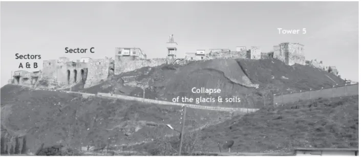
221 Qalaat Al-Mudiq is located on the western slope of the Ghab Valley, perched at c. 100 m above the surrounding plain (Figure 1). At the foot of Jebel Al-Zawiye, the site is close to Apamea on the Orontes, one of the four cities of the tetrapolis created by Seleucos I, around 300 BC. If Apamea is known for its Greek, Roman, and Byzantine phases, and at the beginning of the Islamic period, Qalaat Al-Mudiq is better known for its prehistoric and Bronze Age levels found at its base, and for later Islamic fortifications on its summit (Al Shbib and Gelin 2016). The top of the hill is currently occupied by a modern village whose inhabitants live in the medieval fortifications.
During the winter of 2002-2003, part of the medieval stone glacis covering the slope of the hill collapsed, threatening not only the stability of the fill thus exposed, but also the medieval fortifications1 built on the top of
the mound. The reason for this collapse is that violent rains soaking into the ground caused mounting pressure on the glacis and a resulting landslide of the earthen fill contained by the sloping wall. The glacis collapsed, as it was no longer supported by its lower parts due to an access way to the entrance of the village dug in the 1920s in the slope of the hill and recently enlarged.
1 And of the modern dwellings inside.
Qalaat Al-Mudiq, Citadel of Apamea:
Past and Present
Mathilde Gelin
French National Centre for Scientific Research (CNRS-Nanterre)
Shaker Al-Shbib
Directorate General of Antiquities University of Paris 1, Panthéon-Sorbonne Abstract
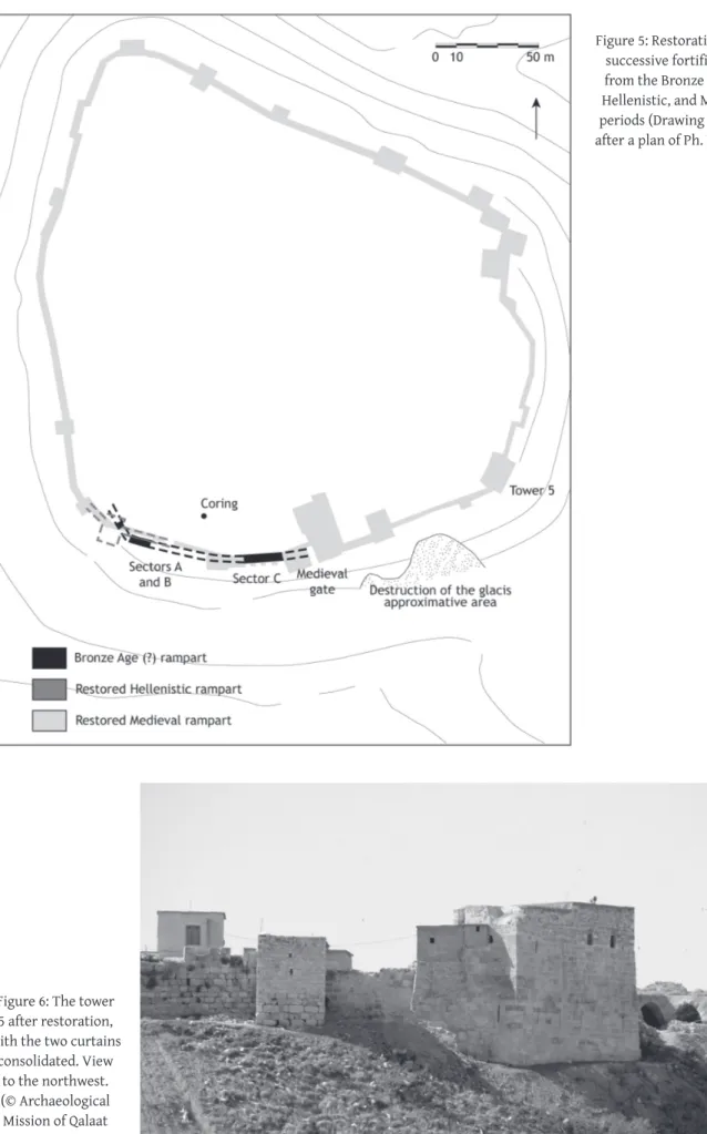
The Syrian-European mission of Qalaat Al-Mudiq/Citadel of Apamea focussed in 2004 and 2005 on emergency consolidation and restoration on the medieval fortifications built on top of the hill, following the collapse of the medieval glacis and part of the slope. A coring was done to verify the stability of the ground and this showed not only that the entire hill is unstable but also that it is an archaeological tell, approximately 20 m thick. Preliminary archaeological soundings were thus done at the bases of the zones to be consolidated, and these yielded ancient fortifications belonging to the Bronze Age and Hellenistic periods. Consolidation and restorations were done at three particularly endangered areas, including a medieval tower. Since then, the monuments have suffered further damage, which all seemed to be repairable, but the entire site is now endangered by the same threat that brought down the medieval glacis.
Figure 1: View of the south front of Qalaat Al-Mudiq, with indication of the fieldworks sectors. View to the north (© Archaeological Mission of Qalaat Al-Mudiq-Citadel of Apamea).
Archaeological Explorations in Syria 2000-2011
222 The General Directorate of Antiquities and Museums of Syria created two missions to intervene on these monuments: one by the University of Architecture in Damascus aimed at stabilizing the glacis and the slope, the other by the European Program of Cultural Heritage Training and the French Institute for the Near East-IFPO to stabilise three sectors of the medieval defence system. This second mission was directed by M. Gelin (IFPO) from 2004, and joined by S. Al Shbib (DGAMS) in 2005.2 This mission led the archaeological excavations
undertaken at the bases of the fortifications to be preserved and the restoration of the structures.3 Qalaat Al-Mudiq in the past
Medieval period
Tower 5, facing the city of Apamea and its theatre, was built on the highest point of the citadel and was an important element of the defence system. It is one of the largest towers in Qalaat Al-Mudiq, about 13 m x 17 m in dimensions and preserved to a height of 12 m. The archaeological work consisted mainly of excavating the tower, inside and out, to examine its base in order to determine the state of the foundations before the restoration operation, and to collect associated archaeological material. These investigations determined that this tower was built over an older building, that it reused some Byzantine material in its foundation, and that it had many stone blocks coming from the ancient theatre. The tower was erected in one phase4 on very strong foundations (going deep into the
slope and on a thick bed of rubble), and conceived as a vantage point to cover the entire valley. It also replaced previous fortifications from the Islamic period. On the slope, a previous stone glacis was covered by the one visible today and appeared to be contemporaneous with the tower: the glacis currently visible (the one that collapsed) belonged to a medieval restoration.
2 We warmly thank the organisers of this Congress for providing the opportunity to point out the importance of Syria’s cultural heritage, especially during these difficult times, and to let us present our researches from Qalaat Al-Mudiq. We also deeply thank all the heads of the institutions and administrations who allowed us to work at Qalaat Al-Mudiq, and N. Khoury, curator of the museum of Apamea. 3 Before this mission, the project managers were E. Al-Ejji-DGAMS (civil engineer) and M. Gelin-IFPO (archaeologist). The participants of the mission were: 1) for the excavations: the two directors, M. Gelin and S. Al-Shbib-DGAMS (archaeologist) for the Hellenistic period, and B. Michaudel-IFPO for the medieval period; 2) for the archaeological material: M.-O. Rousset-CNRS, ceramologist (medieval period), S. Elaigne, ceramologist (Hellenistic period), M. Al-Maqdissi-DGAMS, ceramologist (Bronze Age period), H. David-Cuny (draughtsman); 3) for the building restoration: S. Zugmeyer (architect, tower 5), M. Hijazi-DGAMS (civil engineer, sectors A and B), J.-C. Bessac-CNRS (stone architecture and elements of construction), M. Al Heib-Mines School, Nancy (subsoil stabilisation), A. El Bush-DGAMS and A. Abu Arraj-DGAMS (topographers), and P. Courbon (topographer). 4 Research led by J.-C. Bessac, to be published in a forthcoming publication. See his main results in Gelin 2007: 4-6.
The date of this tower was attributed to the mid-13th century AD (Dangles 2004: 195) after an inscription, although nothing proves that this inscription dates to the time of construction of the tower. However, the date matches the pottery found inside the tower, relating to the Mameluke period (second half of the 13th century AD), according to M.-O. Rousset, and corresponds to the technical building characteristics of the time (between the beginning of the 12th and beginning of 14th centuries AD), according to J.-C. Bessac.
Hellenistic period
West of the entrance to the present village (sector A), a great vaulted room was in danger of collapsing on its southern side. Our team examined the foundations of this side of the building and extended the work westwards, on the upper part of the slope. A stone wall (Figure 2), already visible at the base of the room before our excavations, was associated with other structures found on top of the slope. The plan of these masonries, their technical characteristics (construction, tool marks, dimensions of blocks, and the regular level of their bases and courses, and the pottery sherds found nearby), allowed us to date it with certainty to the Hellenistic period and, probably, to the beginning of this period.5 We also established that these constructions
were linked to fortifications and we were able to restore the plan of the curtain walls and part of a tower. This evidence of Greek fortifications, never established before at Qalaat Al-Mudiq, allows us with great probability to associate the founding of this stronghold to the Seleucids. Qalaat Al-Mudiq obviously represented the citadel of the Seleucid city of Apamea. A possibility exists that it could also be linked to the Lagids at the end of 4th century BC, but we have no evidence for this hypothesis.6
Bronze Age period
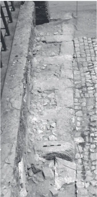
Excavations took place east of the entrance of the current village (sector B) in a vaulted room that needed to be conserved. Surprisingly, the Hellenistic curtain wall from sector A did not appear here. Its stones were probably robbed and reused in later constructions. However, a mudbrick wall, the function of which was not determined, was found associated with pottery dated to the Late Bronze Age.
In sector A, below the Hellenistic wall located at the foot of the vaulted room, excavations uncovered a large
5 Unfortunately, at this state of our research, we cannot be more precise in the dating. The pottery was found on the slope near the structures and not directly associated with them. S. Elaigne dates the corpus from the end of 4th century BC until the first half of 2nd century BC.
6 Antigonos is supposed to have occupied the site and founded a Pella. See Bernard 1995.
223
Mathilde Gelin and Shaker Al-Shbib: Qalaat Al-Mudiq, Citadel of Apamea
wall, 3 m long and 1.70 m high, made of mudbricks (Figure 3). Its western continuation was found in the slope and it is also visible to the east, behind the pillars of the medieval buttress located between sector B and the medieval gate (Figure 4). In this sector C, the erosion of the soils was very active at the top of the slope and exposed this wall. In both sectors A and C, the wall was located exactly at the edge of the slope. If vestiges of this wall from sectors A, B, and C can be associated together, the wall would be at least 92 m long and would constitute a fortification wall (Gelin 2013). However, even though many ceramic sherds from the
Figure 2: Sector A. The Hellenistic stone wall (on the left, modern dwelling; on the right, white stones of a modern stair), view to the east (© Archaeological Mission of Qalaat
Al-Mudiq-Citadel of Apamea).
Figure 4: Sector C. The archaeological layers behind the pillars of the Medieval buttress show a thick mudbrick wall, a probable continuation of the Bronze Age (?) rampart. View
to the north (© Archaeological Mission of Qalaat Al-Mudiq-Citadel of Apamea).
Figure 3: Sector A. Vertical view of the mudbrick rampart probably from the Bronze Age; the north is down (© Archaeological Mission of Qalaat Al-Mudiq-Citadel of
Archaeological Explorations in Syria 2000-2011
224
Figure 5: Restoration of the successive fortifications from the Bronze Age (?), Hellenistic, and Medieval periods (Drawing M. Gelin after a plan of Ph. Dangles).
Figure 6: The tower 5 after restoration, with the two curtains
consolidated. View to the northwest. (© Archaeological Mission of Qalaat Al-Mudiq-Citadel of Apamea).
225
Mathilde Gelin and Shaker Al-Shbib: Qalaat Al-Mudiq, Citadel of Apamea
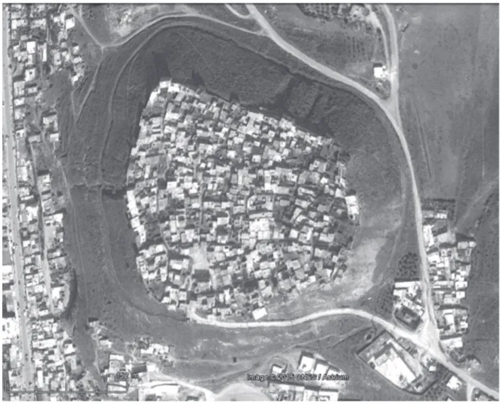
Figure 7: Aerial view of the tell in 2015. The road surrounding it has pierced the stone glacis and the earthen fill. The north is on the top (© Google Earth).
Figure 8: The previous road cut in the 1920s and recently enlarged, which caused the collapse of the glacis and soils of the tell. View to the northwest (© Archaeological Mission of Qalaat Al-Mudiq-Citadel of
Archaeological Explorations in Syria 2000-2011
226 Early Bronze Age were found in the mudbricks, we cannot assert that this wall was built in this period.7
It is obvious, however, that Qalaat Al-Mudiq played a role during the Bronze Age period, as a Bronze Age ceramic sherd – located in archaeological layers some 17 m below the surface level – was found in a coring done on top of the hill for building preservation purposes. All these elements (the mudbrick fortification wall, the associated Bronze Age ceramics, the archaeological layers, the ceramic sherd found in the coring, and the previous discovery of levels from this period at the base of the hill) indicate that Qalaat Al-Mudiq is an archaeological tell, probably dated to the Bronze Age period.
Finally, it can be said that Qalaat Al-Mudiq played the role of a stronghold from, at least, the Bronze Age period until Islamic times. It is noticeable, too, that the fortifications followed the same outline during the three main periods uncovered. However, two important periods in the life of the city of Apamea, Roman and Byzantine, left no remains on the tell, at least in the sectors excavated. Archaeological research will hopefully resume in the future and provide answers to the numerous unanswered questions.
Qalaat Al-Mudiq in the present
Preservation and restoration (Figure 5)
The medieval fortifications are located at the edge of the slope of the tell. Even though they were founded on the earlier, stronger walls (older fortifications), they were destabilised by erosion. The sudden collapse of the glacis highlighted the risks for the walls built either in the same sector or nearby.
The two vaulted rooms, both parts of the entrance to the current village (sectors A and B), were consolidated using the same materials (rubble stones and lime mortar). The eastern part of tower 5 was at the risk of separation from the rest of the building, as it is located partly at the edge of the slope and partly on the slope. The southeast angle was particularly endangered because of extensive vertical cracks. Several stones were also badly damaged in the facings of the tower and inside the eastern gallery of the building. Additionally, the current occupation of the upper level brought water evacuations directly to the foot of the building. Inside the tower, the foundations were exposed. Because of these risks, we made a coring in the village to test the stability of the subsoil: it showed that the entire subsoil is made of unstable soils (archaeological earth
7 We can only say that the earth used to make the bricks was extracted from a place where an Early Bronze Age occupation existed.
of different compositions) with several voids, from the surface of the tell until the bedrock, some 22 m below. After having re-oriented the water canalisations of the modern dwelling,8 our mission undertook the
consolidation and restoration of the medieval tower using mortar injections, fill or replacement of eroded stones, fixing with stainless steel tie-beams the southeast angle, general cleaning of the facings of the walls, and raising the internal levels once the outside ones were stabilised with lime and beaten earth (Gelin 2010). The new stones were selected from a quarry where no black powder was used and their surfaces were hand-cut to give the same appearance as the ‘original’ blocks. The extremities of the curtain walls linked to the tower have also been consolidated and stabilised. As a result of these measures, the tower and the two vaulted rooms were preserved, and, we hope, are out of immediate danger of collapsing again (Figure 6).
Recent damage to the cultural heritage of Qalaat Al-Mudiq
From what we can see from photographs and images, recent events have caused much damage to the buildings we preserved or uncovered. Several of the stones from tower 5 have broken and several new cracks have appeared (Figure 7). In sector C, for example, the pillars have been destabilised, the mudbrick wall is very probably severely damaged, and the medieval gate has also been damaged, showing cracks and the destruction of a window and parts of the upper floor. We hope that these damages are repairable, as it seems they do not severely affect the structure nor the stability of the buildings, except for the pillars and vaults of sector C. However, in our opinion, the most serious problem is the new road that has been dug on the slope of the tell, from the entrance of the village to the base of the hill, surrounding the tell on its western, northern, and eastern sides (Figure 8). As we saw at the beginning of this intervention, it was such a cut that led to the collapse of the glacis and the fill, and that threatened the upper fortifications and dwellings. We hope that the engineers of the General Directorate of Antiquities and Museums will have the possibility to intervene soon to refill the empty spaces with strong materials and to restore the stone glacis, as the stability of the entire archaeological tell is now threatened.
Bibliography
AL SHBIB, S. and GELIN, M.
2016 Qalaat Al Mudiq/Apamean Citadel (Hama). In: Y. Kanjou and A. Tsuneki (eds), A History of Syria in One
Hundred Sites: 427-429. Oxford, Archaeopress.
227
Mathilde Gelin and Shaker Al-Shbib: Qalaat Al-Mudiq, Citadel of Apamea BERNARD, P.
1995 Une légende de fondation hellénistique: Apamée sur l’Oronte d’après les Cynégétiques du Pseudo-Oppien, Topoï Orient-Occident 5/2: 361.
DANGLES, Ph.
2004 La refortification d’Afamyya-Qalat al-Mudiq sous le sultanat ayyoubide d’Alep (fin XIIe-mi XIIIe siècle).
In: J. Mesqui, N. Faucherre, and N. Prouteau (eds), La
fortification au temps des Croisades: 189-204. Rennes,
Presses universitaires de Rennes. GELIN, M.
2013 Note sur le rempart de ‘l’âge du Bronze’ à Qalaat el Mudiq, citadelle d’Apamée de l’Oronte. In: M. Al-Maqdissi, D. Parayre, M. Griesheimer, and E. Ishaq (eds), Un ‘cœur syrien’, Mélanges dédiés à la mémoire
d’Antoine Souleiman: 129-142. Studia Orontica 11.
Damascus, Studia Orontica.
2010 Conservation et mise en valeur du patrimoine archéologique au Proche-Orient: quelques réalisations de missions archéologiques, Journal
of Historical, Philological and Cultural Studies 27-1, En l’honneur des 75 ans de Guénnadi Andréïévitch Koshelenko: 62-84. Moscow, Academy of Science.
2007 Qalaat el Moudiq, citadelle d’Apamée de l’Oronte. Résultats des travaux de 2004. In: J. Abdul Massih (ed.), Résultats du Programme de formation à la
préservation du patrimoine culturel syrien: 357-382
(Arabic version: 383-399). Documents d’Archéologie syrienne 11. Damas, Documents d’Archéologie syrienne.