HAL Id: hal-00917390
https://hal.archives-ouvertes.fr/hal-00917390
Submitted on 11 Dec 2013
HAL is a multi-disciplinary open access
archive for the deposit and dissemination of sci-entific research documents, whether they are pub-lished or not. The documents may come from teaching and research institutions in France or abroad, or from public or private research centers.
L’archive ouverte pluridisciplinaire HAL, est destinée au dépôt et à la diffusion de documents scientifiques de niveau recherche, publiés ou non, émanant des établissements d’enseignement et de recherche français ou étrangers, des laboratoires publics ou privés.
DSM GENERATION FROM STEREOSCOPIC
IMAGERY FOR DAMAGE MAPPING,
APPLICATION ON THE TOHOKU TSUNAMI
Cyrielle Guérin, Renaud Binet, Marc Pierrot-Deseilligny
To cite this version:
Cyrielle Guérin, Renaud Binet, Marc Pierrot-Deseilligny. DSM GENERATION FROM STEREO-SCOPIC IMAGERY FOR DAMAGE MAPPING, APPLICATION ON THE TOHOKU TSUNAMI. International Geosciences and Remote Sensing Symposium, Jul 2013, Melbourne, Australia. �hal-00917390�
DSM GENERATION FROM STEREOSCOPIC IMAGERY FOR DAMAGE
MAPPING, APPLICATION ON THE TOHOKU TSUNAMI
Guérin Cyrielle
1, Binet Renaud
2, Pierrot-Deseilligny Marc
31
CEA/DAM Ile de France
2CNES/DCT Toulouse
3ENSG Marne-La-Vallée
1. INTRODUCTION
Change detection methods from remote sensing are largely investigated, especially for damage mapping after a disaster such as tsunami, earthquake, flood or landslide. In this context, a fast evaluation and localization of the inferred damages is essential for the rescue teams and the authorities [1], [2], [3], an automatic method is then particularly adapted. Today, most of the automatic or semi-automatic change detection methods are based on radiometric changes [2] but a significant amount these changes are irrelevant. An alternative is a change detection method involving objects elevation [4]. The advantage of using this information is that most of the indexed changes are of interest, especially in an urban context.
A previously submitted article describes the fully automatic and generic processing flow we developed for the production of change detection maps from stereoscopic images. This flow consists in the generation of accurate Digital Surface Model (DSM) with an improved image-space based matching technique followed by the detection of real changes from the DSM difference through a classification method with a spatial regularization constraint. In this article, we present the application of this methodology on a real application case, the 2011 earthquake and tsunami occurred on the Tohoku region, in Japan.
2. STUDY AREA
The study area is situated on the north-eastern coast of Japan (Tohoku region) nearby the city of Sendai. On March 11, 2011, a magnitude 9.0 earthquake occurred 130 km away from the coast and generated a tsunami which caused the death of 15,781 people, 4,086 are still missing. It also caused catastrophic damages on buildings, infrastructures and forests localized in the area [2].
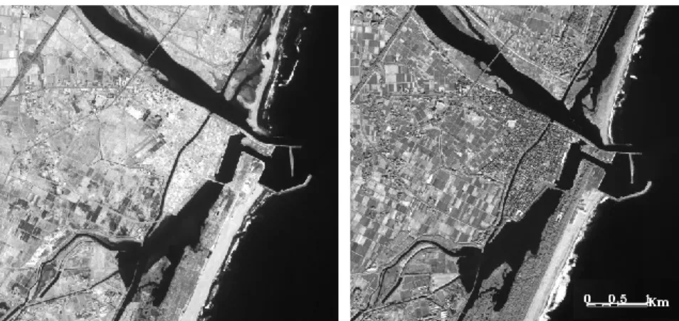
The data set we processed consists of two stereoscopic couples acquire over Sendai coast on December 11, 2010 and August 13, 2011, both by the Ikonos sensor and resample at 1m spatial resolution. According to the panchromatic images (Figure 1), radiometric changes of the area are particularly important and would raise numerous alarms of changes with a radiometric-based change detection method, especially over agricultural areas.
Figure 1 : Ikonos panchromatic images of the most affected region of Tohoku before (left) and after the tsunami (right).
3. METHOD 3.1. DSM Generation
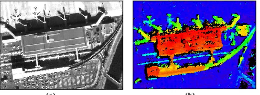
The comparison of the objects elevation (buildings, infrastructures or forest) before and after the crisis allows an accurate evaluation of the inferred damages. This difference of elevation is obtained through the generation of two DSM from the stereoscopic images acquired at each date of interest.
The method developed for the DSM generation is based on a semi global matching [5] and consists in a matching from the image space [6]. In order to process the images symmetrically, the matching is performed twice and the outcomes DSMs are fusioned by an optimized process with a spatial regularization constraint (not described in this article). The objective of this fusion is to choose, for each pixel of the final DSM, the value of one of the computed DSM or a value corresponding to occlusions areas.
The advantages of this technique are, first, a better consideration of the occlusions areas from both images, the edges of the structures are thus better handled, and the computation of a more robust DSM to correlation errors (Figure 2(b)). Indeed, the production of accurate DSMs at each date is essential for their comparison.
3.2. Change Detection method
The differential DSM is obtained by a pixel to pixel difference. However, because of the remains of numerous miscorrelation errors in the DSMs due to various sources such as vegetation, vehicles or homogeneous features, a naïve threshold on the DSM difference would generate a very high false alarm rate on the change detection map.. The relevant changes are then highlighted through an original classification method based on an optimization function with a spatial regularization. This function depends on the elevation difference as an agreement function and on the labels variation (positive, negative or no change) between two consecutives pixels as a spatial regularization.
(a) (b)
Figure 2: (a) Image crop of an Ikonos stereoscopic couple from the 11/12/2010. (b) Fusioned DSM.
This classification is based on the fact that the label of a pixel is likely to be the same than the label of the neighbor pixel, theory close to the Markov Random Fields [7].
Eventually, the balance between the elevation difference, computed on a pixel, and the labels variation is adapted according to the researched changes. A low regularization will lead to a high detection sensibility to the finest changes but also to a high false alarm rate. In return, a high regularization will remove most of the false alarms but the sensibility will then be lower.
4. EXPERIMENTATION AND RESULTS
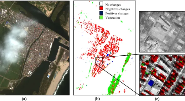
The methodology has been tested over the Tohoku region. Over this coastal area, most of the anthropogenic structures correspond to low buildings and pavilions, often close to each others. Consequently, the regularization is defined with a low value so that most of the buildings are considered and intact buildings among destroyed once are not missed and vice versa. Yet, the coastal region also includes large vegetation areas severely damaged. In order to separate vegetation and buildings damages, a multi spectral images from Ikonos sensor, acquired before the crisis on August 4, 2010, has also been processed and a vegetation mask, derived from the NDVI (Normalized Vegetation Index) has been computed.
Finally, the generated change detection map allows observing the bounds of this damaged area (Figure 3(a) and (b)). The result shows that most of the buildings situated on the coast have been destroyed and only a few were preserved while debris have been stacked on certain places of the sinister area (Figure 3(c)). Besides, the whole forest situated along the coast has been removed by the wave. However, it appears that the damages are much lower in the North West, areas furthest from the coast.
5. CONCLUSION
We described a new approach of change detection from remote sensing based on the elevation changes. The advantage of using this information rather than the radiometry, like in many other studies, is the high relevance of the detected changes, essential for fast damage estimation in a crisis context. Besides, we showed, on a submitted article, that more than 75% of the usual buildings changes of a stable urban environment are detected.
(a) (b) (c)
Figure 3: (a) Ikonos Multi-spectral image
from the
11/12/2010. (b) Change detection maps obtained by the processing flow with a low regularization. (c) Zoom on the damaged area before and after the tsunami.The processing flow requires the generation of accurate DSMs from stereoscopic images, obtained with a new combined correlation and fusion technique. The elevation changes are then highlighted with an automatic classification with a regularization constraint allowing a better control on the false alarm rate according to the size of the researched changes.
The presented methodology is completely automatic and generic to process any high resolution sensors, which makes it particularly adapted for a fast mapping of the damages inferred by natural disaster.
6. REFERENCES
[1] D. Brunner, L. Bruzzone, and G. Lemoine. Change detection for earthquake damage assessment in built-up areas using very high resolution optical and sar imagery. In Geoscience and Remote Sensing Symposium, IGARSS 2010. IEEE International, pages 3210 -3213, july 2010.
[2] H. Gokon, S. Koshimura, Mapping Of Building Damage Of The 2011 Tohoku Earthquake Tsunami In Myagi Prefecture. In Coast. Eng. J. 54, Issue 01, March 2012.
[3] A.-L. Chesnel, R. Binet, and L. Wald. Object oriented assessment of damage due to natural disaster using very high resolution images. In Geoscience and Remote Sensing Symposium,. IGARSS 2007. IEEE International, pages 3736 –3739, july 2007.
[4] Jiaojiao Tian and P. Reinartz. Multitemporal 3d change detection in urban areas using stereo information from different sensors. In Image and Data Fusion (ISIDF), 2011 International Symposium on, pages 1 –4, aug. 2011.
[5] H. Hirschmuller. Accurate and efficient stereo processing by semi-global matching and mutual information. In Computer Vision and Pattern Recognition, 2005. CVPR 2005. IEEE Computer Society Conference on volume 2, pages 807 – 814 vol. 2, june 2005.
[6] M. Pierrot-Deseilligny L. Penard, N. Paparoditis. 3d building facade reconstruction under mesh form from multiple wide angle views. In In proceedings of the 20th ISPRS Congress, 2005.
[7] L. Bruzzone and D.F. Prieto. Automatic analysis of the difference image for unsupervised change detection. Geoscience and Remote Sensing, IEEE Transactions on, 38(3):1171 –1182, may 2000.
No changes Negatives changes Positives changes Vegetation