Publisher’s version / Version de l'éditeur:
Proceedings 7th International Offshore and Polar Engineering Conference,
ISOPE'07, 2, pp. 498-503, 1997
READ THESE TERMS AND CONDITIONS CAREFULLY BEFORE USING THIS WEBSITE.
https://nrc-publications.canada.ca/eng/copyright
Vous avez des questions? Nous pouvons vous aider. Pour communiquer directement avec un auteur, consultez la
première page de la revue dans laquelle son article a été publié afin de trouver ses coordonnées. Si vous n’arrivez pas à les repérer, communiquez avec nous à [email protected].
Questions? Contact the NRC Publications Archive team at
[email protected]. If you wish to email the authors directly, please see the first page of the publication for their contact information.
NRC Publications Archive
Archives des publications du CNRC
This publication could be one of several versions: author’s original, accepted manuscript or the publisher’s version. / La version de cette publication peut être l’une des suivantes : la version prépublication de l’auteur, la version acceptée du manuscrit ou la version de l’éditeur.
Access and use of this website and the material on it are subject to the Terms and Conditions set forth at
A Methodology for Developing a Scientific Basis for the Ice Regime
System.
Frederking, Robert; Timco, Garry; Santos-Pedro, V.
https://publications-cnrc.canada.ca/fra/droits
L’accès à ce site Web et l’utilisation de son contenu sont assujettis aux conditions présentées dans le site LISEZ CES CONDITIONS ATTENTIVEMENT AVANT D’UTILISER CE SITE WEB.
NRC Publications Record / Notice d'Archives des publications de CNRC:
https://nrc-publications.canada.ca/eng/view/object/?id=1f89c9b5-8001-4131-a559-0df39eeb60a4 https://publications-cnrc.canada.ca/fra/voir/objet/?id=1f89c9b5-8001-4131-a559-0df39eeb60a4Reprinted from: Proceedings 7Th International Offshore and Polar Engineering Conference, ISOPE’07, Vol. 2, pp 498-503, Honolulu, USA, 1997.
A Methodology for Developing a Scientific Basis
for the Ice Regime System
G.W. Timco
1, R.M.W. Frederking
1and V. M. Santos-Pedro
21
Canadian Hydraulics Centre National Research Council
Ottawa, Canada
2
Transport Canada Prairie & Northern Region
Ottawa, Canada
Abstract
Transport Canada has developed an Ice Regime System which defines the conditions in which vessels can safely navigate in ice-covered waters. This System, which was developed in support of the Arctic Shipping Pollution Prevention Regulations, has important implications for ships operating in Canadian waters and potentially for polar navigation. To ensure that these regulations represent realistic guidelines for ship navigation in ice, it is necessary to have them based on a scientific approach. To this end, a logical approach has been developed to provide a platform for this scientific basis. The approach is based on an empirical evaluation of the behaviour of ships in ice-covered waters. It is developed in 7 different Tasks. This paper provides a short introduction to the existing Ice Regime System, and presents the methodology for developing a scientific basis for the Ice Regime System.
Introduction
Navigation in Canadian waters north of 60 degrees north latitude is regulated by Shipping Safety Control Zones. A Zone/Date matrix gives entry and exit dates for various ship types and classes. It is a rigid system with little room for exceptions, relying on nature to consistently follow a regulatory table.
The Ice Regime System is intended to introduce the necessary flexibility by making use of actual ice conditions, ultimately as seen by the Master. Responsibility to plan the route, identify the ice, and carry out a simple numeric calculation rests with the person in charge of the watch. Authority by the regulator to direct ships in danger or during an emergency remains unchanged. Due care and attention of the mariner, including avoidance of hazards (say, icebergs) is vital to the successful application of the Ice Regime System.
The need for a simple, effective, and fair system for shipowner and regulator alike, meant that it is empirical, based on the experience of navigators gained over the last 20 years using modern ships and advanced navigation equipment.
Accurate, reliable and timely ice information contribute greatly to introduction of a navigation control system that is responsive to rapid changes in climate conditions. As designed, the system will favor ships with the most knowledge and information.
Credibility of the new system has wide implications, not only for ship safety and pollution prevention but also in lowering ship insurance rates and predicting ship performance. Many verification voyages using the Ice Regime System attest to its validity and usefulness as well as some shortcomings - while certain sea passages may be safely done at low speed by a very knowledgeable and experienced navigator, the simplicity of the system may result in a negative entry.
Any changes to the Ice Regime System must be carefully done, in a controlled manner. Therefore, the need to identify the scientific basis of the system is of primary importance.
Transport Canada approached the National Research Council of Canada in Ottawa to assist them in developing a methodology for establishing a scientific basis for the Arctic Ice Regime System (AIRS). This lead to a “road map” approach which is based on 7 Tasks (Timco and Frederking 1996).
In this paper, the existing Ice Regime System is discussed, and shortcomings of the system are presented. The development and rational behind each of the 7 Tasks are discussed, along with the framework for the implementation of the proposed approach.
The Ice Regime System
An ice regime is any area composed of a relatively even distribution of any mix of ice types, including open water. The World Meteorological Organization (WMO) nomenclature is used to describe the ice types. These ice types are defined on the basis of both age and thickness. Multi-year ice is usually thicker and stronger than first- or second-year ice. The ice thickness is inferred from the ice type.
In the proposed regulations, the ship’s structure must be designed to withstand impacts with a maximum thickness of ice (ASPPR 1989). This is the thickest ice type in which a properly navigated ship may operate without risk of structural damage. The regulations define 9 categories of vessels such that each ship category is related to an ice type. Table 1 presents the nine ship categories along with the corresponding ice type for each category. Note that no equivalent Arctic classes of other Classification Societies are given in the table, since equivalency can only be done on a ship-by-ship basis. An ice regime has two components: 1) ice that is above the “category ice” for the vessel; and 2) ice at and below the “category ice” for the vessel. These two components always total 10/10ths. In any given ice conditions, the ratio of the two components will differ between ship categories, since each ship category has a different ice type. The risk of damage, therefore will depend on the proportions of hazardous ice (i.e. above the category ice) and non-hazardous ice (i.e. at or below the category ice) in the regime, and on the ability of the ship to avoid the hazardous ice types.
Table 1. Ice Type for each Ship Category
SHIP
WMO ICE TYPE RANGE CATEGORY
(m)
Multiyear Ice (MY) > 3 CAC 1
Second Year Ice (SY) > 2 CAC 2
Thick First Year Ice (TFY) > 1.2 CAC 3 Medium First Year Ice (MFY) 0.7 - 1.2 CAC 4 Thin First Year Ice - Second Stage (THFY2) 0.5 - 0.7 TYPE A Thin First Year Ice - First Stage (THFY1) 0.3 - 0.5 TYPE B
Grey-White Ice (GW) 0.15 - 0.3 TYPE C
Grey Ice (G) 0 - 0.15 TYPE D
Open Water (OW) 0 TYPE E
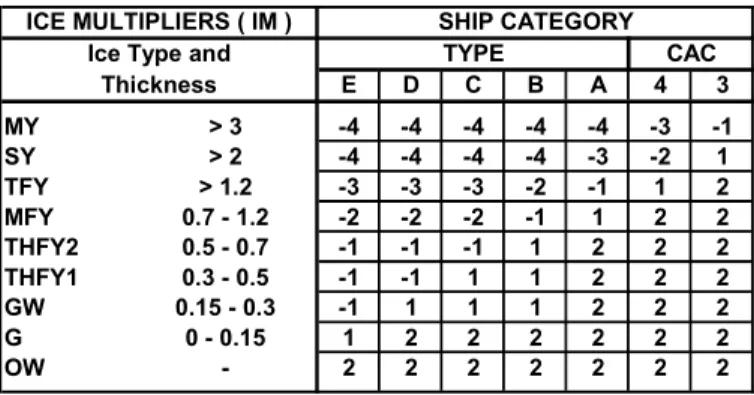
To quantify the ice regime, a scheme has been developed which takes into account the relative amount of each type of ice, and relates it to the ship category. This is reflected through an Ice Multiplier (IM). The value of the Ice Multiplier reflects the level of danger that the particular ice type poses to the particular category of ship with the larger negative numbers representing larger hazards. Table 2 lists the Ice Multiplier values for each ship category.
For any ice regime, an Ice Numeral (IN) is calculated by taking the sum of the products of the concentrations of the ice types present (in 10ths), and their ice multiplier. The Ice Numeral is defined as:
IN = (Ca X IMa) + (Cb X IMb) + ... (1)
where IN is the Ice Numeral, Cn is the concentration (in tenths)
of ice type “n”, and IMn is the Ice Multiplier from Table 2.
The right side of the equation is expanded to include all the types of ice that are present, including open water. The Ice Numeral is therefore unique to the particular ice regime and category of ship operating within its boundaries. The system takes into account ice decay and ice ridging. For decayed ice, the multipliers are increased by 1 for second-year ice, and thick and medium first-year ice. The numbers for multi-year ice are not changed. If ridges are present in a concentration greater than 6/10ths, the multipliers are decreased by 1. This reflects the higher level of risk presented by the thicker ice.
Table 2 Ice Multipliers for each Ship Category
ICE MULTIPLIERS ( IM ) SHIP CATEGORY
Ice Type and TYPE CAC
Thickness E D C B A 4 3 MY > 3 -4 -4 -4 -4 -4 -3 -1 SY > 2 -4 -4 -4 -4 -3 -2 1 TFY > 1.2 -3 -3 -3 -2 -1 1 2 MFY 0.7 - 1.2 -2 -2 -2 -1 1 2 2 THFY2 0.5 - 0.7 -1 -1 -1 1 2 2 2 THFY1 0.3 - 0.5 -1 -1 1 1 2 2 2 GW 0.15 - 0.3 -1 1 1 1 2 2 2 G 0 - 0.15 1 2 2 2 2 2 2 OW - 2 2 2 2 2 2 2
For any given ship category, entry or non-entry into an ice regime is determined by the sign of the Ice Numeral. If the IN is negative, entry is not allowed. However, if the IN is zero or
positive, then entry by the ship into that ice regime is allowed.
In order to use the Ice Regime System, a vessel must have access to relevant ice information that is both accurate and current, and as importantly, is reliably made available for shipboard decision making. Clearly, this type of ice information is required to define details of the ice conditions that will be encountered along a particular vessel's transit route and in turn, calculate Ice Numerals. The system is designed to enable vessels that have comprehensive information on the ice conditions to proceed, as long as it can be done safely. Vessels that have minimal information on the local ice regime may be hampered in certain circumstances.
In Canada, information regarding the ice cover is usually obtained from the range of products that are provided by the Atmospheric Environment Service's (AES) Branch of Environment Canada. The most important product that AES currently provides to vessels is the daily ice chart, which
summarizes regional ice conditions in areas of interest to active marine operations. The information that is used to generate these ice charts is in transition. It includes visual and imaging radar observations (SAR and SLAR) acquired from periodic AES surveillance aircraft overflights, various forms of satellite imagery, and "as available" ship, helicopter reconnaissance and shore station reports. Although most mariners now feel that the level of ice information is adequate, there is no doubt that the use of new technology, such as RADARSAT, will significantly alter the amount, accuracy and timeliness of ice information. These changes, coupled with new commercial products and a willingness of the shipping community and AES to continue communicating regarding ice information needs and adequacy, should improve the level of ice information that is currently made available to support voyage planning and execution, and the application of the Ice Regime System.
For the past several years, there has been over 20 field trials to evaluate the suitability of the Ice Regime System (Norland 1994). In addition, there has been considerable discussion of the system, most notably at dedicated workshops on the topic (Dickins 1990; Norland 1991; Daley 1994). From these trials and workshops, a number of important points have been raised:
• On several voyages, negative ice numerals were calculated, at least for short segments, yet the ship traversed the ice safely;
• Different ice observers have estimated quite different concentrations of ice types for the same ice regime;
• The Ice Regime System does not take into account • vessel speed
• visibility
• Ice information supplied by the AES often underestimated the initial growth of the ice, and was not informative on the details of second year ice distribution in a region;
• Ice information from the AES does not take into account the decay of first-year ice;
• Information from AES was not always presented in a clear fashion for the Ice Regime System. Ice charts are sometimes “cluttered” with information;
• The importance of ice ridging did not seem to be adequately addressed;
• Quantifying the effect of ship escort was difficult;
• The amount of time that a ship will be in a specific ice regime is important. This time directly relates to the risk of damage;
• The variance of experience of the various ship Masters is not considered in the System.
With the successes and concerns regarding the Ice Regime System, it is prudent to ensure that the system is based on a scientific foundation, both for reliability and confidence in its use. A proposed methodology is presented in the next section.
Overall Methodology for the Scientific Basis
It is important to have a logical strategy in order to develop the Ice Regime System in a scientific manner. This section will describe an overall methodology to implement this change. In developing the strategy, there were a number of key points that were used as guidelines:• The System should be based on the ice conditions that cause problems for each class of ship - these have to be determined through specific events;
• The System must focus on addressing issues related to ship safety and pollution prevention, and not on the operational performance of the vessel;
• The System must be designed such that it is easy to apply by the ship operators;
• The System must satisfy the needs of Transport Canada in their application of pollution prevention measures;
• The System could also account for extrinsic conditions, other than ice characteristics - for example, ship speed, poor visibility, etc.;
• The System should try to make use of available information on the ice characteristics from both on-board and remotely-sensed systems, with its application in a very pragmatic manner.
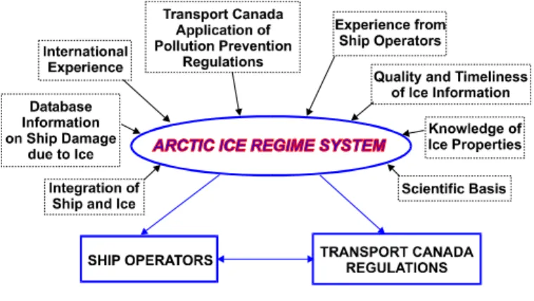
The development of this system must include all of these factors. Figure 1 shows the context diagram for the proposed Arctic Ice Regime System. It shows the essential inputs into a scientifically-based system, and the important inter-relationship between the safety regulations of Transport Canada and the necessary operational efficiency of Ship Operators.
Figure 1 Context diagram for the Ice Regime System.
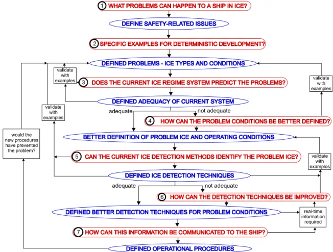
In developing the present methodology, a very simple strategy was employed. The system is based on asking and answering seven basic questions. Each question is a logical extension to the answer of the previous question. The basic questions are:
1. What problems can happen to a ship in ice?
2. What are specific examples of problems that have occurred which could be used for a deterministic development? i.e. specific case-histories that can be used to identify and understand the problems.
3. Would the current ice regime system predict these problems?
4. If not, how can the problem conditions be better defined? 5. Can the current ice detection methods identify the problem
ice conditions?
6. If not, how can the ice detection systems be improved in a pragmatic manner to be able to detect the problem ice? 7. How can this information be communicated to the ship to
implement the Ice Regime System?
The answer to each question provides the input into the next question in a logical fashion. Figure 2 shows a general flowchart for the proposed methodology. The work is divided into 7 Tasks that correspond to each of the questions, procedure and answers to the above 7 questions. Clearly, in answering the questions, important information will be required from a variety of sources. In addition, detailed knowledge of ice characteristics, ship behaviour and operational procedures will be key ingredients in the overall plan. There must be a number of verification procedures implemented to ensure that the methodology is based on actual field data. Each of the Tasks will be briefly discussed.
1. Define Safety-Related Issues - This task will systematically review historical data on the safety-related problems that a ship could encounter in ice. The output of the task is a classification of safety-related issues and identification of a comprehensive set of data sources. 2. Definition of Specific Problems with the Corresponding
Ice Conditions - In this task, a large number of specific examples of ship-ice problems will be detailed. A major effort will be made to assess all available data sources including those developed by Transport Canada and international projects (e.g. Keinonen et al. 1992; Vefsnmo
et al. 1995). In using these data sources, the events will be
viewed to develop an understanding of the ice characteristics that caused the problem for the ship, as well as any other extrinsic circumstances such as vessel speed, visibility, etc. Cases where both damage and no-damage occurred will be identified. This data will provide a scientific guide to the type of ice characteristics that can cause problems for each class of vessel. A specific effort will be directed to quantifying the degree of damage based on the ship- and ice-related characteristics. Analysis will be carried out to investigate the damage as a function of ship speed, momentum and kinetic energy, with respect to the ice thickness, strength and concentration. The output from this task will be a series of “damage maps” that show the ice conditions that may cause damage for each vessel class.
This information, organized in this manner is the key to developing a scientific basis for the ice regime system. 3. Assess Adequacy of AIRS - In this task, the current Ice
Regime System will be used to assess how accurately it would have predicted damage (or no-damage) to the vessel for all cases developed in Task 2.
4. Definition of Problem Ice and Operating Conditions - In this task, the ice conditions that cause problems for each of the different class of vessels will be better defined. Detailed knowledge of ice properties and operators’ experience are crucial to the successful completion of the task. New approaches to improve the definition of the ice regime will be explored. At the end of this Task, the Arctic Ice Regime System will be based on scientific evidence related to known ship behaviour in ice conditions.
5. Identification of Problem Ice - Once the “problem” ice conditions are known, it is necessary to see if they can be easily identified using the on-board and/or remote ice detection techniques. In this task, each of the techniques will be briefly reviewed with an eye towards the success of each technique for detecting the problem ice conditions. An important part of this process will be the essential ingredient of quick transmission of the ice conditions to the vessel. There will be a number of important contributors to this task, including ship operators, the Canadian Atmospheric Environment Service, and the Canada Centre for Remote Sensing.
6. Detection of Problem Ice - If the current detection techniques cannot provide the necessary information, a pragmatic study of the type of improvements that could be made will be undertaken. Developing expensive detection and/or analysis systems that may or may not work will not be part of this task. If current detection techniques are judged adequate, information from some of these systems will be analyzed in a different manner in order to provide the necessary information for the implementation of AIRS. To ensure the practicability of this task, the input of people with a knowledge of ship operations, remote sensing, and ice properties will be sought.
7. Implementation of AIRS - The final task will be to tie together the Ice Regime System with the available ice information in a user-friendly package for the vessel. A key ingredient will be the ease of use and general confidence in the methodology by the ship operators. There are several potential approaches that could be developed to perform this task. The most appropriate will have to be developed with input from the ship operators and the AES. At the conclusion of this task, there will be a viable ice regime system that is based on scientific data and is user-friendly to the end user. As an adjunct to this Task, the full implementation of the System will be achieved with adequate education and communication to those responsible for using and applying it.
Relation to Other Ice Navigation Systems
In Russia the "Ice Passport" (Likhomanov et al. 1993) and the "QAD" system (Brovin et al. 1996) are used to manage ice navigation. The "Ice Passport" is unique to each vessel and sets out a safe operations envelope which relates speed limits to ice conditions. The "QAD" system is operationally oriented, taking information on ice thickness and length of transit in each ice thickness to optimize route selection. Developing a link between the Russian systems and the AIRS is a goal of the project.
The AIRS is based on ice information derives from the WMO ice classification. The classifications are based primarily on ice thickness as originally interpreted from aerial over-flights. Now, with remote sensing satellites, it is possible to obtain ice images in digital form in various spectrums. There is considerable effort underway to relate this digital information to the WMO classifications and also derive additional information about the ice conditions. The European Union is
supporting one such project to improve the characterization of ice regimes; i.e. developing a more representative means of characterizing the "ice state" (Riska, personnel communication). The ice state could well be a more objective means of defining ice conditions and one which may be more relevant to defining safe and efficient operations of vessels in ice.
Summary and Conclusions
This paper has presented an overview of a proposed Canadian approach for developing a scientific basis for the Ice Regime System. The core of the approach is a verified relationship between the ice conditions and vessel category and low risk of damage. The approach is structured in 7 Tasks that each are formulated in terms of a question, a methodology for answering the question, and an answer to the question. When complete, this work should provide a valuable tool in support of the safe and efficient operation of ships in ice.
Acknowledgements
The authors would like to acknowledge the helpful comments on this work supplied by Brian Wright, Mohamed Sayed, Claude Daley, Andrew Kendrick and Bryan Kerman.
References
ASPPR, 1989. Proposal for the Revision of the Arctic Shipping Pollution Prevention Regulations. Transport Canada Report TP 9981, Ottawa. Ont., Canada.
Brovin, A., Tsoy, L. and others. 1996. Planning and Risk Assessment Volume 2 - 1994 Project Work. INSROP working Paper No.34,-1996, I5.5.
Daley, C. 1994. Workshop on the Scientific Basis of the Ice Regime System. Report to Canadian Coast Guard Northern, Transport Canada Report TP 12255, Ottawa, Ont., Canada. Dickins, DF. 1990. Workshop Results: Experience with the Proposed Ice Regime Control System. Report to Canadian Coast Guard Northern, Transport Canada Report TP 10612, Ottawa, Ont., Canada.
Keinonen, A., Revill, C. and Brown, R. 1992. Review of the Proposed Revisions to CASPPR Study Area C: Damage. Report prepared for Memorial University, St. John’s, Nfld. Likhomanov, V.A. and others. 1993. Principles for the Development and Prospective Use of the Ice Passports. Proceedings POAC’93, Vol. 1, pp 219-226, Hamburg, Germany.
Norland Science & Eng. 1991. Workshop on the Ice Regime Shipping Control System. Calgary, Al. (unpublished).
Norland Science & Eng. 1994. Field Evaluation Trial of the Proposed ASPPR Ice Regime System CCGS Des Groseilliers. Report to Canadian Coast Guard Northern, Transport Canada Report TP 11921, Ottawa, Ont., Canada.
Timco, G.W. and Frederking, R.M.W. 1996. A Methodology for Developing a Scientific Basis for the Ice Regime System. National Research Council of Canada Report HYD-TR-009, Ottawa, Canada.
Vefsnmo, S., Lovas, S., Backlund, A. And Ranki, E. 1995. INSROP Natural Conditions and Ice Navigation: Content of Database, Planning and Risk Assessment. SINTEF Report STF60F95085, Trondheim, Norway.