HAL Id: insu-01944377
https://hal-insu.archives-ouvertes.fr/insu-01944377
Submitted on 12 Dec 2018
HAL is a multi-disciplinary open access archive for the deposit and dissemination of sci-entific research documents, whether they are pub-lished or not. The documents may come from teaching and research institutions in France or abroad, or from public or private research centers.
L’archive ouverte pluridisciplinaire HAL, est destinée au dépôt et à la diffusion de documents scientifiques de niveau recherche, publiés ou non, émanant des établissements d’enseignement et de recherche français ou étrangers, des laboratoires publics ou privés.
Distributed under a Creative Commons Attribution - NonCommercial - NoDerivatives| 4.0
AgrHyS: An Observatory of Response Times in
Agro-Hydro Systems
Ophélie Fovet, Laurent Ruiz, Gérard Gruau, Nouraya Akkal-Corfini, Luc
Aquilina, Sylvain Busnot, Rémi Dupas, Patrick Durand, Mikaël Faucheux,
Yannick Fauvel, et al.
To cite this version:
Ophélie Fovet, Laurent Ruiz, Gérard Gruau, Nouraya Akkal-Corfini, Luc Aquilina, et al.. AgrHyS: An Observatory of Response Times in Agro-Hydro Systems. Vadose Zone Journal, Soil science society of America - Geological society of America., 2018, 17 (1), 16 p. �10.2136/vzj2018.04.0066�. �insu-01944377�
AgrHyS: An Observatory of Response
Times in Agro-Hydro Systems
Ophélie Fovet,* Laurent Ruiz, Gérard Gruau, Nouraya Akkal,
Luc Aquilina, Sylvain Busnot, Rémi Dupas, Patrick Durand,
Mikael Faucheux, Yannick Fauvel, Chris Fléchard, Nicolas
Gilliet, Catherine Grimaldi, Yannick Hamon, Anne Jaffrezic,
Laurent Jeanneau, Thierry Labasque, Geneviève Le Henaff,
Philippe Mérot, Jérôme Molénat, Patrice Petitjean,
Anne-Catherine Pierson-Wickmann, Hervé Squividant, Valérie
Viaud, Christian Walter, and Chantal Gascuel-Odoux
The AgrHyS is a long-term agro-hydrological observatory dedicated to study-ing the processes controllstudy-ing hydro-chemical fluxes in headwater catchments in response to the effects of agricultural. AgrHyS is composed of instrumented catchments located in western France in a temperate oceanic climate that are characterized by shallow groundwater (<8 m deep) over crystalline bedrocks (granite or schist) and is dominated by intensive agriculture with farming. AgrHyS provides long-term observations starting in 1990 and supports highly interdisciplinary studies that provide novel contributions to environmental sciences, including hydrology, geochemistry, agricultural and soil sciences, hydrogeology, bioclimatology, and ecology. Here we describe the observa-tory sites, observation strategy, data management policy, and data access. The objective is to show how AgrHyS has contributed to research in hydrological and environmental sciences through a review of major insights of the research. This analysis highlights the role of AgrHyS in linking, validating, and enriching successive and complementary projects conducted over the last 25 yr. The sec-ond objective is to invite new collaborations with a large scientific community for future research.
Abbreviations: DOC, dissolved organic carbon; DOM, dissolved organic matter; ERO, Environmental Re-search Observatory; OC, organic carbon; SDI, spatial data infrastructure.
The AgrHyS observatory of response times in agro-hydro systems, located in western
France, is dedicated to the observation of agro-hydrosystems under a temperate climate char-acterized by shallow groundwater and intensive agriculture, mainly of annual crops receiving a high amount of mineral and organic inputs. AgrHyS is composed of instrumented catch-ments where environmental variables are monitored over the long term to study the processes controlling hydro-chemical fluxes in agroecosystems, with the objective of characterizing their response time to climatic and agricultural impacts. AgrHyS contains two sites—the Kervidy-Naizin catchment and the Kerbernez catchment—where research has been conducted since the early 1970s. In 2002, AgrHyS was declared by the French Ministry of Research as an Environmental Research Observatory (ERO). Whereas a recent review by Gascuel-Odoux et al. (2018) analyzes the coevolution of research topics with observatories and methods used in Environmental Sciences based on the 50-yr history of the Kervidy-Naizin site, the present article highlights the synergies between the observations at the two sites based on the review of the missions and accomplishments of AgrHyS hydrological observatory since.Long-term observatories, such as AgrHyS, serve different missions and have several objectives: facilitate research, provide reference data sets, test methodologies, train new scientists, and educate the public.
The main activity performed in AgrHys is scientific research. The evolution of the science questions that have guided the strategy of observations over time and the
Core Ideas
• AgrHyS is a long-term observatory of the agroecosystem.
• AgrHyS supports strongly interdisci-plinary environmental research. • AgrHyS offers an original
experi-mental setup to explore the soil–groundwater–water–plants– atmosphere continuum.
• AgrHyS supports original and inno-vative techniques for environmental monitoring.
O. Fovet, L. Ruiz, N. Akkal, S. Busnot, R. Dupas, P. Durand, M. Faucheux, Y. Fauvel, C. Fléchard, N. Gilliet, C. Grimaldi, Y. Hamon, A. Jaffrezic, G. Le Henaff, P. Mérot, H. Squividant, V. Viaud, C. Walter, and C. Gascuel-Odoux, UMR SAS, INRA, AgroCampus Ouest, 65 rue de St Brieuc, 35 042 Rennes, France; G. Gruau, L. Aquilina, L. Jeanneau, T. Labasque, P. Petitjean, and A.-C. Pierson-Wickmann, UMR 6118 Géos-ciences Rennes, CNRS, Univ. Rennes 1, OSU Rennes, 263 avenue du Général Leclerc, 35 042 Rennes, France; J. Molénat, LISAH, Univ. Montpellier, INRA, IRD, Montpellier SupAgro, Montpellier, France. *Corresponding author (ophelie.fovet@inra.fr).
Received 2 Apr. 2018. Accepted 21 Aug. 2018.
Citation: Fovet, O., L. Ruiz, G. Gruau, N. Akkal, L. Aquilina, S. Busnot, R. Dupas, P. Durand, M. Faucheux, Y. Fauvel, C. Fléchard, N. Gilliet, C. Grimaldi, Y. Hamon, A. Jaffrezic, L. Jean-neau, T. Labasque, G. Le Henaff, P. Mérot, J. Molénat, P. Petitjean, A.-C. Pierson-Wick-mann, H. Squividant, V. Viaud, C. Walter, and C. Gascuel-Odoux. 2018. AgrHyS: An observatory of response times in agro-hydro systems. Vadose Zone J. 17:180066. doi:10.2136/vzj2018.04.0066
Special Section: Hydrological Observatories
© Soil Science Society of America.
This is an open access article distributed under the CC BY-NC-ND license
(http://creativecommons.org/licenses/by-nc-nd/4.0/).
main characteristics of the catchments are described herein. Observations are conducted to test hypotheses and understand processes, but over the years, they also led to the identification of new environmental issues for science and society (Gascuel-Odoux et al., 2018).
AgrHyS also produces data sets that will serve as references for biophysical systems. The characterizations and monitoring performed in AgrHys are described based on the level of their acquisition (basic long-term observations, dedicated observa-tions associated with specific research programs, experiments, and surveys). Producing relevant datasets requires continuously updating methodologies. New technologies that can monitor multiple parameters in a more automated way or at higher fre-quency must be tested and validated before widespread adoption. Observatories such as AgrHyS are particularly suitable for test-ing new technologies because the long-term observations already conducted (basic set) provide a good comparison data set. A special focus is given on innovative methods tested in AgrHyS (Ayraud et al., 2008; Faucheux and Fovet, 2014; Floury et al., 2017; Gilliet et al., 2018; Jeanneau et al., 2014; Merot et al., 1994, 1995).
One of the major interests of environment observatories is to provide physical ranges and trends of spatial or temporal variation for parameters or processes that can be compared with observa-tions. This can contribute to cross-calibration of models and meta-analyses. For such goals, all data and associated metadata have to be made available to the scientific community. The data management policy and the database of AgrHyS and its access procedure are discussed below.
Major scientific advances achieved at the AgrHyS observatory are also reviewed herein. An additional important product of the AgrHyS observatory team is the formalization of a representative understanding of hydrological systems, which are transferable to other catchments. Accordingly, AgrHys contributes largely to the production and development of modeling approaches. Observations are a basis for modeling designed to test hypotheses (Beaujouan et al., 2001; Dupas et al., 2016; Fovet et al., 2015a; Gascuel-Odoux et al., 2010; Hrachowitz et al., 2014; Molenat et al., 2008; Ruiz et al., 2002a, 2002b) or to explore scenarios (Beaujouan et al., 2002; Benhamou et al., 2013; Durand et al., 2015; Moreau et al., 2012; Salmon-Monviola et al., 2013).
Additionally, training and education is important for the AgrHyS observatory. On average, AgrHyS sites host field studies for about seven PhD or Master’s degree students yearly. No fewer than three Master 2 curriculums include practical work and field trips that are built on AgrHyS sites and datasets. Many researchers conducting projects on AgrHyS are teachers who build part of their lectures on the observations from AgrHyS. Occasionally, these sites also support outreach to water managers, policymakers, and local farmers.
Finally, we present the perspective for the development of AgrHyS in relation to emergent scientific questions, methodologi-cal advances, and integration within national and international networks of observatories.
6
Historical Context
The catchments of AgrHyS were instrumented for assessing the effects of agriculture in France and Europe on water and soil quality. French Brittany, western France, is emblematic of the agricultural revolution: since the Second World War, it has been one of the most productive agricultural regions in Europe. Intensive farming has deeply modified landscapes: from “bocage” closed by hedgerow net-works to open fields, drained wetlands, and the massive replacement of continuous grasslands by annual arable crops. The first results in the mid-1970s showed a rapid increase of nitrate concentrations in streams and rivers. Effects on the catchment water balance and on soil losses by erosion were also suspected. In the mid-1990s, awareness of environmental damages due to agricultural intensification led to implementation of environmental policies (e.g., the 1991 European Nitrates Directive) to relax the agricultural pressures on environ-mental resources (mainly water and soil in those days). Despite the reductions in fertilizer inputs and improved management of farm manure, nitrate concentrations in rivers and streams remained stable and high, revealing much longer response times of catchment systems than expected (e.g., Howden et al., 2011a, 2011b; Jarvie et al., 2013). After such observations, the question of response times of catchments became central for water management. For research, it implied the need to characterize solutes and water pathways within the system, which control both their residence times and reactivity. Agricultural scientists, hydrologists, soil scientists, and hydro-biogeochemists worked together at the small catchment scale to understand the response times of surface water to changes in land management. Shared research observatories are ideal supports for such interdisciplinary approaches toward understanding the processes controlling catchment responses. Long-term observations led to formulating hypotheses. Additional punctual data collection enabled testing these hypotheses, and the modeling approaches pro-vided conceptualization to generalize the understanding. Thus, the catchment scale was recognized to be relevant for developing a sys-temic approach to evaluating the impacts of agricultural systems on the environment. Consequently, the exploration of environmental parameters was extended to the whole catchment to understand the spatial organization of landscapes (soil maps, spatial rainfall variability) and intensified in specific hot spots (wetlands, ground-water) moving from the rainfall–discharge relation, as an in-out approach, to a landscape hydrology–hydrochemistry approach and using a wide range of chemical species as geochemical tracers. The observation activity was amplified regarding the number of monitored compartments and species. The complementarity of the monitoring between both sites was designed according to the need for characterizing both transit times and reactivity: high tempo-ral resolution of the monitoring and sampling in Kervidy-Naizin catchment focusing on the stream and high spatial resolution in Kerbernez catchments over outlets and merely groundwater. In the mid-2000s, the study of the nutrient cycles altered by intensive agriculture was also extended to determine the importance of the gaseous phases of the N cycles (N cascade; Galloway et al., 2003) and the linkage between geochemical C–N–P cycles. This systemic
approach of catchments as agroecosystems led to investigating the role of biological factors in those cycles, progressively involving microbiologists and soil ecologists in the observatory.
As the observation data records were extended, the relevance of such observatories to conduct new observations increased. Since the 1970s, AgrHyS has offered a unique opportunity for Environmental Sciences to capitalize on long-term observations. Indeed, all the acquired knowledge contributed to the design of new campaigns and the interpretation of their results. Therefore, environmental observatories became ideal support for enhancing interdisciplinary approaches. Moreover, considering the temporal and spatial scales of processes that control water and solute transfer in catchments, the investigation of these processes requires pluri-decadal data time series. In 2002, under the name of ERO, AgrHyS became part of a network of catchments and sites that increasingly allowed synergy and complementarity among existing research sites.
6
Catchment Characteristics
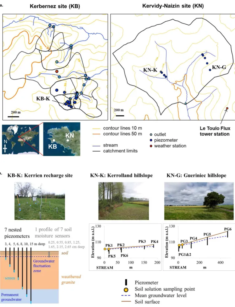
Sites of the AgrHyS ERO are headwater catchments and first- and second-order streams (Fig. 1). The Kervidy-Naizin catchment covers 5 km2 in central Brittany (latitude, 47.95; longitude, −2.8;
WGS84). The Kerbernez site has a network of seven catchments with areas between 0.1 and 0.6 km2 in southwestern Brittany
(lati-tude, 47.94; longi(lati-tude, −4.1; WGS84).
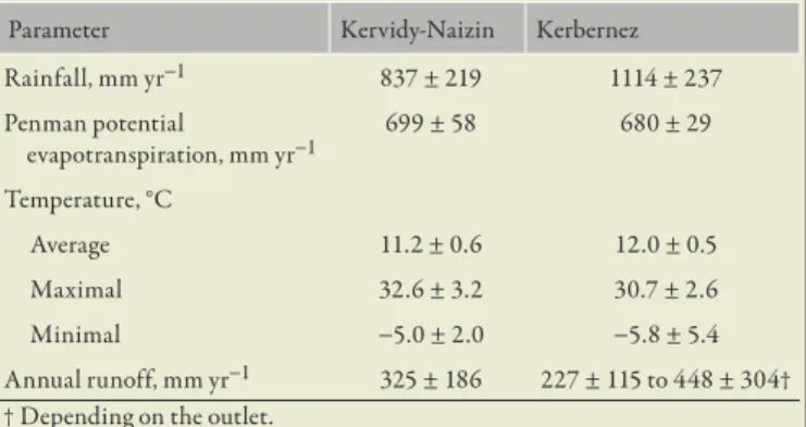
The climate is temperate and humid at both sites with a regional west–east gradient between sites. Average values of water balance terms are given in Table 1. The geological bedrock consists of low-permeability crystalline rocks with a similar structure: above the impervious bedrock there is a fissured and fractured layer in which water is likely to percolate deeply. The fractured layer is mantled by a weathered layer where shallow groundwater can fluctuate. In the Kervidy-Naizin site, the bedrock is composed of upper Proterozoic schists, whereas in the Kerbernez site it is granite known as the Leucogranodiorite of Plomelin. The two major bedrock types of the Brittany region are thus represented in the AgrHyS ERO. The weathered zone is 1 to 30 m deep in the Kervidy-Naizin site, with hydraulic conductivity ranging from 4 × 10⁻⁶ to 2 × 10⁻⁵ m s−1 and
40 to 50% total porosity. In the Kerbernez site, the weathered layer is 20 to 40 m deep, with hydraulic conductivity between 2 × 10⁻⁶
and 5 × 10⁻⁴ m s−1 and 42 to 60% total porosity.
Slopes are gentle at both sites (<5% on average). The soils are silty loams in Kervidy-Naizin between 0.5 and 1.5 m deep, and in Kerbernez there is mainly sandy loam that is 0.8 m deep on average. Soils are well drained except in bottomlands close to the streams, where water excess leads to hydromorphic, poorly drained soils and Albeluvisols (Fig. 2). Soil hydraulic conductivity at saturation ranges from 10−5 to 10−6 m s−1 in Kervidy-Naizin and from 10−5
to 10−4 ms−1 in Kerbernez. The superficial soil layers (0–40 cm
in Kervidy-Naizin and 0–20 cm in Kerbernez) are rich in organic matter (2.5–6.5% in Kervidy-Naizin and 4.5–6% in Kerbernez).
Land use is dominated by intensive agriculture, with sys-tems mixing cropping and indoor dairy and pig farming. In
2013, these catchments were mainly covered by maize, straw cereals, and grasslands. In Kervidy-Naizin these main land cover types correspond to 38, 30, and 15% of arable area, respectively, whereas in Kerbernez they vary between 10 and 70%, between 5 and 24%, and between 0 and 6% of arable area, respectively, depending on the catchment. In some Kerbernez catchments, the number of abandoned or converted fields (i.e., into a golf course) is increasing.
6
Basic Long-Term Observations
The current observation protocol of AgrHyS consists of long-term records of meteorological, hydrological, and hydro-chemical variables and land cover maps. The longest time series started in 1993. The variables currently available in the long-term observa-tion set are detailed in Table 2 according to the locaobserva-tion, frequency of acquisition, and onset year of acquisition, and the corresponding station locations are shown in Fig. 1.
Weather
Since 1993, the Kerbernez and Kervidy-Naizin sites have been equipped with a weather station located 1 km from the farthest outlets (Fig. 1). The station records hourly rainfall, air and soil temperatures, air humidity, global radiation, and wind direction and speed, which allows the calculation of daily Penman evapotranspiration.
Discharge
Between 1995 and 1997, the outlets were equipped with U-notch or V-notch weirs for monitoring the stream water level. Most gauging stations are automated and use float-operated sen-sors that record stream level sub-hourly (from 1 to 10 min). In a few outlets in Kerbernez (Table 2), stream level is measured manually every month to catch base flow variations. Stream flow is deduced from the stream level with a rating curve. Since 1999, the level sen-sors have been connected to a data logger.
Groundwater Levels
From 1997 to 2005, a network of piezometers was installed in the two sites to monitor shallow groundwater fluctuations and variations in its chemical composition (see below). Currently, 31 piezometers are monitored on AgrHyS sites. They are between 3 and 20 m deep and are encased within PVC tubes screened along the bottom 0.5 or 1.0 m of their length. The space around the PVC tube is backfilled with sand, bentonite, and concrete. The water table level is measured using automatic transducer sensors, some-times coupled with temperature and electrical conductivity sensors that record water table data every 15 min in most piezometers (and manually in the others every month).
Stream Water, Groundwater, and Rain Water
Chemical Composition
Various elemental concentrations are analyzed in the water sampled at AgrHyS sites depending on the station: major anions (Cl,
Fig. 1. (a) Location of the sites and main stations of the AgrHyS observatory, and (b) detailed equipment of highly instrumented stations or transects located on the site maps as labeled in both panels.
NO2, NO3, SO4), major cations (Ca, Mg, K, Na), dissolved organic C (DOC) and dissolved inorganic C (sometimes coupled with Fe), total and soluble reactive phosphorus, and suspended solids. These concentrations are measured using grab sampling mostly. Various water quality parameters are also measured using sensors (electrical conductivity, temperature, turbidity, NO3 and DOC concentrations, and total reactive and total P concentrations).
Grab samples have been conducted since 1993 in the stream to collect in situ standard physicochemical data. Monitoring has been intensified since 1999. Rain water composition has been investigated since 2010. The highest frequency of sampling in the stream (Kervidy outlet) is 1 d since 1999 (Fig. 3), and the highest frequency of groundwater sampling (Kerbernez piezom-eters) is 1 wk (between 2005 and 2012). Automatic samplers are used to sample storm flow events every 10 to 30 min over 10 h, which is consistent with the duration of such events in the catchments. The sampling is started when stream level reaches a threshold determined according to base flow conditions. Between 4 and 10 events are monitored every year. Since 2007, some complementary, nearly continuous (15–10 min) monitoring of physicochemical variables has been conducted using dedicated sensors: turbidity and concentrations of NO3, organic C, and P
in stream water and temperature and electrical conductivity in stream and groundwater.
Land Cover
The evolution of land cover from one year to another is a basic variable of the observatory. Depending on the year, land cover data were obtained by farm survey or in-field observations or were
Table 1. Average values and standard deviation of hydro-meteorological variables at the AgrHyS observatory sites.
Parameter Kervidy-Naizin Kerbernez Rainfall, mm yr−1 837 ± 219 1114 ± 237 Penman potential evapotranspiration, mm yr−1 699 ± 58 680 ± 29 Temperature, °C Average 11.2 ± 0.6 12.0 ± 0.5 Maximal 32.6 ± 3.2 30.7 ± 2.6 Minimal −5.0 ± 2.0 −5.8 ± 5.4 Annual runoff, mm yr−1 325 ± 186 227 ± 115 to 448 ± 304†
† Depending on the outlet.
Ta bl e 2 . B as ic a nd d ed ic at ed l on g-te rm o bs er va tio ns c ur re nt ly c on du ct ed a t t he A gr H yS o bs er va to ry . F re qu en ci es o f o bs er va tio ns a re a ss oc ia te d t o e ac h v ar ia bl e i n t he n ei gh bo r c ol um n a s w el l a s t he d at e of th e m on itor in g on se t. St at ion s A tm os ph er ic va ria ble s† H yd ro lo gi ca l v ar ia bl es ‡ O th er p hy sic al v ar ia bl es C he m ica l va ria ble s§ Va ria bl e Ti m e step Fi rs t date Va ria bl e T im e s te p Fi rst d ate Va ria bl e T im e s te p Fi rst d ate Va ria bl e T im e s te p Fi rst d ate K er ber ne z 1 W ea th er s ta tion ai r a nd s oi l t em pe ra tu re , glo ba l r ad iat ion a nd P A R , w ind s pe ed a nd d ire ct ion , ra in , hu m id ity 1 h 19 93 bu lk i n r ai nw at er : N O3 , C l, S O4 , N H4 , C a, M g, N a, t ot al N 1 m o 201 3 3 O ut let s stre am l ev el 6 m in 19 98 o r 2 00 2 te m pe rat ur e 10 m in 201 0 o r 2 01 3 NO 3 , S O4 , C l 8/ yr 19 91 o r 2 00 1 EC 10 m in 201 3 pH , 8/ yr 20 01 2 O ut let s stre am l ev el 6 m in 19 98 o r 2 00 2 pH , tempe ra tu re , EC 8/ yr 20 01 NO 3 , S O4 , C l 8/ yr 19 97 2 O ut let s stre am l ev el 8/ yr 19 98 pH , tempe ra tu re , EC 8/ yr 20 01 NO 3 , S O4 , C l 8/ yr 19 91 o r 2 00 1 1 H yp or he ic z one te m pe ra tu re 10 m in 201 2 7 Pi ez om et er s w at er t ab le l ev el 15 m in 20 01 o r 2 00 5 te m pe ra tu re 15 m in 20 07 o r 2 01 0 NO 3 , S O4 , C l 8/ yr 20 01 o r 2 00 5 EC 15 m in 201 0 o r 2 01 3 pH 8/ yr 20 01 o r 2 00 5 5 Pi ez om et er s w at er t ab le l ev el 15 m in 20 01 o r 2 00 5 te m pe ra tu re 15 m in 20 07 o r 2 01 0 NO 3 , S O4 , C l 8/ yr 20 01 o r 2 00 5 pH , E C 8/ yr 20 01 o r 2 00 5 3 Pi ez om et er s w at er t ab le l ev el 15 m in 20 01 o r 2 00 5 NO 3 , S O4 , C l 2/y r 20 01 o r 2 00 5 3 Pi ez om et er s w at er t ab le l ev el 15 m in 20 01 o r 2 00 5 te m pe ra tu re , E C 15 m in 201 0 o r 2 01 3 NO 3 , S O4 , C l 2/y r 20 01 o r 2 00 5 pH , E C 2/y r 20 01 o r 2 00 5 1 Pi ez om et er w at er t ab le l ev el 8/ yr 20 01 pH , tempe ra tu re , EC 2/y r 20 01 3 S oi l p ro fil es 21 s oi l m oi stu re s30 m in 201 0 Kervi dy -N aiz in 1 W ea th er s ta tion ai r a nd s oi l t em pe ra tu re , glo ba l r ad iat ion a nd P A R , w ind s pe ed a nd d ire ct ion , ra in , hu m id ity 1 h 19 93 bu lk i n r ai n w at er : NO 3 , C l, S O4 , N H4 , C a, M g, N a, t ot al N 1 m o 201 3
St at ion s A tm os ph er ic va ria ble s† H yd ro lo gi ca l v ar ia bl es ‡ O th er p hy sic al v ar ia bl es C he m ica l va ria ble s§ Va ria bl e Ti m e step Fi rs t date Va ria bl e T im e s te p Fi rst d ate Va ria bl e T im e s te p Fi rst d ate Va ria bl e T im e s te p Fi rst d ate 1 F lu x t owe r ne t r ad iat ion a nd P A R , ai r t em pe ra tu re + h um id ity , at m os ph er ic p re ssu re , r ai n, he at flu x, w ind s pe ed a nd d ire ct ion 30 m in 20 15 CO 2 flu x t o at m os phe re 20 H z 20 15 so il m oi stu re ( −5 , − 20 , − 50 c m ) 30 m in 20 15 so il t em pe ra tu re , EC 30 m in 20 15 ac tu al E T 20 H z 20 15 K er vi dy ou tle t stre am l ev el 1 m in 19 94 te m pe ra tu re 10 m in 201 0 NO 3 1 d + 1 5 m in + 5 sto rm s/y r 19 93 (< da ily ), 1999 (d ai ly) , 20 10 ( 15 m in ) DOC 1 d + 1 5 m in + 5 sto rm s/y r 1999 (d ai ly) , 20 10 ( 15 m in ) EC 201 3 SO 4 , C l 1 d + 5 s tor m s/ yr 19 93 (< da ily ), 1999 (d ai ly) D IC 1 d + 5 s tor m s/ yr 1999 (d ai ly) tu rb id ity 20 04 SS 3 d + 5 s tor m s/ yr 20 07 to ta l P , S R P 1 d + 3 0 m in + 5 sto rm s/y r 20 07 (b iw ee kly ), 20 13 (d ai ly) , 20 16 (3 0 m in) K er vi dy ou tle t’s hy po rh eic z one te m pe rat ur e 10 m in 201 0 9 Pi ez om et er s w at er t ab le l ev el 15 m in 19 98 te m pe rat ur e 10 m in 20 07 o r 2 01 0 NO 3 , S O4 , C l, D O C , D IC 4/y r 20 00 so il s ol ut ion conc en tr at ion i n NO 3 , S O4 , C l, D O C , DI C , S R P, Fe II 1 w k t o 1 m o 201 3 1 Pi ez om et er w at er t ab le l ev el 15 m in 19 98 te m pe ra tu re 15 m in 201 0 NO 3 , S O4 , C l, D O C , D IC 4/y r 20 00 soi l moi stu re (− 5 c m ) 30 m in 201 3 so il t em pe ra tu re (− 5 c m ) 30 m in 201 3 NO 3 , S O4 , C l, D O C , D IC 4/y r 20 00 2 Pi ez om et er s w at er t ab le l ev el 4/y r 19 98 te m pe ra tu re 15 m in 201 0 NO 3 , S O4 , C l, D O C , D IC 4/y r 20 00 † E T, e va po tr an sp ira tion ; P A R , p ho to sy nt he tic al ly a ct iv e r ad ia tion . ‡ E C , e le ct ro cond uc tiv ity . § DI C , d iss ol ve d i no rg an ic C ; D O C , d iss ol ve d o rg an ic C ; S R P, s ol ub le re ac tiv e p ho sp ho ru s; S S, s us pe nd ed s ol id s.
reconstructed from remote data by analyzing and classifying the information contained in images. The main annual land use in each field is recorded, at least in the case of cover crops. The land cover maps over the period 1993 to 2018 account for the modifica-tions of the field limit over time.
6
Dedicated Long-Term Observations
AgrHyS is a real-life laboratory for research dedicated to specific research issues. Such studies benefit from the basic obser-vation data sets and can reciprocally produce new data collection. Part of these additional observations is conducted for the duration of the project or even through several successive projects, leading to dedicated medium- to long-term data sets.
Soils
The first soil maps were established in the early stages of the research sites (Lamandé, 2003; Walter, 1993) (Fig. 2) to provide an extensive description of the spatial organization of soils and connect them to their hydrological and geochemical functioning (Walter and Curmi, 1998). High-resolution soil maps (1:10,000 and 1:25,000) have been established on the basis of four criteria: soil parent material, soil depth, soil redoximorphic conditions, and soil types as defined in the French soil classification (Baize et al., 2002).
The physicochemical properties of soils (texture, pH, nutrient con-tent, organic matter, trace elements) have been measured over the catchment, and hydrodynamic properties of soil horizons (hydrau-lic conductivity, porosity) have been quantified for the main soil types. In more recent research projects, additional soil collection campaigns have been conducted in the Kervidy-Naizin site to quan-tify C, N, and P stocks in the soil compartment and to characterize the biochemical processes controlling C, N, and P cycling in soils. Detailed data on soil C, N, and P content; soil aggregation; and microbial communities (molecular microbial biomass estimated by soil DNA recovery, bacterial and fungal communities analyzed by 16S and 18S rRNA gene pyrosequencing) (Matos-Moreira et al., 2017) have been collected. These data are captured in databases, which will allow for long-term monitoring of soil evolution (e.g., in C content) if such sampling campaigns are renewed.
Soil moisture sensors have been in use since 2010 in specific loca-tions of the catchments and according to different strategies. At the Kerbernez site, 21 frequency domain reflectometry sensors are coupled with nested piezometers to monitor the groundwater recharge pro-cess. Volumetric soil water content is recorded at −0.25, −0.55, −0.85, −1.25, −1.65, −2.15, and −2.65 m depths (Fig. 1b) over three profiles; groundwater fluctuations below are also recorded. At the Kervidy-Naizin sites, time domain reflectometry sensors (often coupled with temperature sensors) are used either on soil profile (at −5, −20, and
−50 cm deep) or in the upper layer of soil (−5 cm) to interpret measure-ments of gaseous fluxes (CO2, N2O) conducted in successive research projects. The time step of acquisition ranges from 15 to 30 min.
Soils are key components to understanding the exports of several chemical elements to surface water. At the Kerbernez sites, successive PhD theses focused on the composition of recharge and on its variation with time and with space along the hillslope. Recharge water was sampled using profiles of ceramic cups between −25 cm and −2.5 m on which suction was applied for water col-lection (Legout et al., 2005, 2007). At the Kervidy-Naizin site, the chemical composition of soil water has been investigated since 2011 over a succession of projects focused on organic matter and P. Bottomland soils and wetland soils have been instrumented with zero-tension lysimeters and mini-piezometers to allow the sam-pling of free water in soils (Denis et al., 2017a, 2017b; Dupas et al., 2015b; Gu et al., 2017; Lambert et al., 2011). These samples are analyzed to determine their concentrations in anions, dissolved C (and Fe), and dissolved P, in addition to any other variables of interest. This soil water monitoring set up has been deployed on the Kervidy-Naizin site only and for monitoring the water chem-istry over the soil–groundwater–stream continuum.
Agricultural Practices and Activities
To further interpret and model nutrient transfer over catch-ments, detailed information about agricultural practices is needed. Such information includes crop rotations (to control land cover maps and to fill potential gaps in them), fertilizer application, phy-tosanitary application, crop residues management, livestock size and types, animal feeding, and manure and dejection management. Farming activity is a key characteristic of AgrHyS because it leads to a diversity of inputs (nutrients, veterinary products) in the ecosys-tem. The acquisition of such information on agricultural practices and systems requires detailed farm surveys, which are too demand-ing and too expensive to be conducted every year. The number of farms in the study catchment is thus a key element for the feasibil-ity of such surveys. On the Kerbernez site, where each catchment is composed of a few fields only, the survey is focused on the two most instrumented catchments and is conducted every 4 yr. The Kervidy-Naizin site includes 47 farms, all or part of whose fields are within the boundaries of the catchment. Therefore, such surveys are usually conducted within dedicated projects, and three detailed surveys were conducted since 1993: Cheverry conducted a study in 1993 (Cheverry, 1998, p. 85–108), in 2008 a survey focused on the livestock production system at the farm scale, and in 2013 a survey founded on a specific study of dynamics of organic matter investi-gated the cropping systems (i.e., crop rotations and crop management practices at the field scale for each farm) (Viaud et al., 2018).
Surface–Atmosphere Exchange Fluxes
Because evapotranspiration is a key component of the water budget, it is important to verify estimates provided by models using actual measurements of evapotranspiration. Eddy covari-ance–based flux towers that allow for such measurements (Lee et
al., 2004) are expensive and have one important limitation in the context of catchment hydrology because the fluxes are typically measured at the field scale, rather than across the whole landscape. A flux tower station was installed in 2015 over grazed grassland (Fig. 1a), recording surface/atmosphere H2O and CO2 fluxes con-tinuously over a few years to capture their seasonal and interannual variability. During the day, CO2 fluxes are linked to H2O fluxes via photosynthesis and transpiration of the vegetation, which is controlled by bulk canopy stomatal conductance; during the night soil and plant respiration proceed. Fluxes are measured by eddy covariance, and a set of ancillary meteorological and soil variables is recorded on site (Table 2). The measurement height is 2 m, cor-responding to a flux footprint of the order of 1 to 3 ha depending on wind speed, atmospheric turbulence, and stability.
Analyzing Water Chemistry
at Higher Temporal Resolution
The generation of new monitoring tools is emerging with a lot of promises for improving the understanding of hydrochemical processes with higher temporal frequency of water composition observations (van Geer et al., 2016; Wade et al., 2012). Indeed, despite the wide availability of techniques for continuous monitor-ing of hydrological variables, the continuous monitormonitor-ing of water quality in situ is still technically challenging for use in manage-ment. As a research observatory, AgrHyS ERO is also a place for technical innovation because the high number of monitored parameters provides an ideal framework for testing new tools. Thus, several technologies have been or are being tested regarding their ability to provide water concentrations at resolution >1 h.
Sensors that estimate concentrations using indirect methods including in situ ionic specific probes and spectrophotometric probes were installed in 2010 to monitor NO3, Cl, and organic C concentrations. They have been tested in stream and piezom-eters on both AgrHyS sites, leading to satisfactory results for the spectrophotometer, which records NO3 and dissolved organic C every 15 min (Faucheux and Fovet, 2014). Ionic specific probes have been found more reliable for spatial campaigns than for con-tinuous monitoring at a given point.
The most recent generation of tools is based on river bank side analyzers, which pump water directly from the stream and deter-mine concentrations by direct physicochemical methods equivalent to those used in the laboratory in real time, avoiding storage and transport issues. Recent research revealed that the improvement of P monitoring frequency was key for characterizing storm processes and for estimating annual P exports (Minaudo et al., 2017). Thanks to this project, a P analyzer has recorded total and reactive P in the Kervidy-Naizin site since 2016 every 30 min (Jordan et al., 2007). The challenge to increase the temporal resolution of analysis for vari-ous chemical elements in water is also taken up with the development of a river laboratory prototype (Floury et al., 2017). A second proto-type measures major ion concentrations (by ionic chromatography), dissolved silica (colorimetry), and organic C (acid mineralization and infrared CO2 measurement) approximately every 30 min in
stream water at the outlet of the Kervidy-Naizin site. Such records help to reduce the uncertainty associated with elemental balances of catchments and help to track hydrological flow paths.
6
Dedicated Campaigns
and Experiments
Campaigns for Dynamic Mapping of Wetlands
in Space and Time
According to their role in overland flow generation (Beven and Kirkby, 1979) and their role as hot spots for biogeochemical reac-tions (Sabater et al., 2003), wetlands have been the subject of several research projects. In impervious bedrock low-order catchments such as those of AgrHyS, wetlands result from the combination of climate, topography, and geomorphology zones in areas where the water table intercepts shallow soil horizons (Crave and Gascuel-Odoux, 1997). Such combinations are dynamic in space and time. Wetlands inven-tories have been made on the field by visual identification and by helicopter-borne radar (Gineste et al., 1998; Merot et al., 1994). Thanks to the inventory, a method for mapping those wetlands from a
digital elevation model and using a climate-topographic index (Merot et al., 2003) has been developed and used on other AgrHyS sites.
Geophysical Campaigns and Experimental
Determination of Hydrodynamic Properties
To characterize the hydrodynamic properties of the weathered rock, slug tests and pumping tests were performed in some of the piezometers to provide estimates of hydraulic conductivity (Martin et al., 2006; Molenat and Gascuel-Odoux, 2002; Molénat et al., 2005; Pauwels, 1994; Vouillamoz, 2003).
In the Kerbernez site, these tests were combined with geo-physical surveys (electrical imaging, electromagnetic and magnetic resonance sounding) and indicate that the thickness of the weath-ered granite increases from upslope toward downslope areas of the catchments in the form of a deep graben structure (Legchenko et al., 2004). Subsequently, an experimental determination of weath-ered material was performed using the Wind method (Rouxel et al., 2012), showing that the retention curve of weathered granite is different from soil retention curves and cannot be easily estimated using pedotransfer function approaches.
Tracer Experiments and Use of Geochemical
and Isotopic Tools
Hydrological and geochemical deconvolution can use various tracers to identify contributive flow paths and biogeochemical reaction processes or to estimate water and element residence times in catchment compartments such as soil, vadose zone, or groundwater. Various tracers have been used on AgrHyS sites for different objectives.
In the Kervidy-Naizin site, a lot of projects were dedicated to storm flow generation and associated exports of dissolved organic matter (DOM). Storm flow deconvolutions based on water iso-topes (δ18O) showed the small portion of recent water in storm
hydrographs (Merot et al., 1995), pointing to the importance of old water from soil and groundwater in the genesis of storm flow. Then, several tracer approaches were used and compared to identify
and quantify the contributions of different compartments to DOC export during storm events and thereby also to improve our under-standing of subsurface flows. The δ13C of C (Lambert et al., 2011,
2013, 2014), the fluorescence signature, and the molecular composi-tion of DOM (Denis et al., 2017a; Jeanneau et al., 2014) confirmed the major contribution of riparian wetlands to storm DOC and emphasized a secondary contribution of downslope areas, which decreased along successive storms. The fluorescence signature also emphasized the potential direct contribution of animal manure to the stream DOM during intense spring storm events.
In the Kerbernez sites, tracer experiments have been conducted to gain a better understanding in groundwater recharge. The first attempt to use 2H in tracer campaigns at the scale of shallow
piezom-eters was not conclusive, most likely because of excessive transfer times. Tracer experiments with Br and 2H helped to estimate the
water velocity in soils and showed the bimodal properties of the velocities. Enzymatic activity was also used in combination with solute concentrations in laboratory experiments to characterize the biogeochemically reactive transfer in the soil and the weathered zone, showing that heterotrophic denitrification was the dominant pro-cess (Legout et al., 2005, 2007). Groundwater age was determined using atmospheric tracer chlorofluorocarbons and SF6, highlighting the distinction between the weathered zone (where apparent ages ranged from 12 to 25 yr) and the weathered-fissured and fractured parts (where apparent age increased with depth and was >25 yr) (Ayraud et al., 2008; Molénat et al., 2013). In both AgrHyS sites, shallow groundwater feeds the streams; therefore, different experi-mental tools have been explored to quantify the subsurface fluxes and their temporal or spatial variations. Preliminary tests on radon were started in 2015, and studies on temperature using distributed temperature sensing by optic fiber were started in 2016).
Atmospheric Emissions and Deposition
Atmospheric mass transfer of key elements (water vapor, CO2, N species), as part of complex and multiple pedosphere/hydro-sphere/biosphere/atmosphere interactions, is important for the understanding and mass budgeting of soil and hydrological com-partments within a landscape-like catchment, even at the scale of headwater catchments. The N cascade (Galloway et al., 2003) illus-trates the importance of those interactions in an elemental budget. The understanding of the hydrochemical fluxes (H2O, C, and N, in particular) and their importance in biogeochemical cycles thus requires adequate monitoring of element fluxes and concentra-tion in the atmosphere. Several campaigns have been conducted since 2007 on AgrHyS sites to assess various fluxes, such as CO2, N2O, and NH3, at the landscape scale. For example, Buysse et al. (2016) measured soil CO2 efflux with closed dynamic respiration chambers over a 1-yr period (36 weekly to biweekly measurement dates) at 22 sites across the Kervidy-Naizin catchment. They found that water regime, land-use, and crop rotation significantly
affect soil CO2 emissions, with lower emissions observed in poorly drained soils either due to lower respiration or to limited CO2 transport in saturated soils. A network of passive and low-cost sen-sors for atmospheric NH3, which integrates concentrations over monthly periods, was also established across the catchment (Tang et al., 2001). These low-resolution atmospheric NH3 data were complemented by mobile NH3 plume measurement campaigns, downwind of the main agricultural NH3 sources (animal housing), using fast-response (1 s) quantum cascade laser technology. These datasets were used to improve landscape-scale estimates of total NH3 emissions as well as local dry deposition, which contribute significantly to the total N load of agroecosystems in areas of inten-sive animal farming (Bell, 2017).
6
Data Management and Policy
A database dedicated to basic long-term observations was cre-ated in 2002 and is now fed with observations relcre-ated to the specific research projects hosted at the AgrHyS site. It is a POSTGRESQL database hosted on a virtual server provided by INRA InfoSol Orléans. The data are accessible via a web connection (https:// www6.inra.fr/ore_agrhys_eng/Data). Recent and ongoing work on this database includes data not archived in the initial version (data before 1999–2000) and has reorganized the data integration pro-cess according to the evolution of sensor technologies and associated evolution of treatment methods and tools during the past decade.
The structure of the database has been reviewed to allow for the dissemination of raw information and expert knowledge used to process data. All treatments are thus trackable by comparison of raw and processed data, and qualification procedures for pro-cessed data can be automated thanks to this tracking by assigning a reliability score. Thanks to this double information, the treat-ment procedures can be shared between operators. All data for which treatments are performed outside the AgrHyS observatory team (e.g., weather data processed by INRA AgroClim research unit, past data processed by operators that are no longer part of the team, chemical analyses processed by laboratory) are only provided as processed data qualified as “unknown reliability.” AgrHyS is contributing to the Open Data initiative with respect to the FAIR guiding principles (findability, accessibility, interoperability, reus-ability). Special care is given to data that can be related to personal information (e.g., about individual farmers, such as specific prac-tices or punctual gaseous emissions from livestock buildings) with respect to the General Data Protection European Regulation and the associated French Data Protection Act (Loi Informatique & Libertés), which guarantees data privacy when relevant.
Different services have been developed to facilitate data access and reuse while insuring their interoperability thanks to the respect of international standards. All services and data are accessible thanks to a spatial data infrastructure (SDI) named GeoSAS (based on the SDI GeOrchestra, http://geowww.agro-campus-ouest.fr/portails/?portail=vidae). The metadata catalog is integrated into the GeoNetwork open source. Spatial data are
stored on the open source GeoServer designed for interoperability and linked to a visualizing interface for locating and download-ing monitordownload-ing stations and spatial data. Another service provided by GeoSAS SDI is a tool named VIDAE (http://agrhys.fr/BVE/ vidae/) devoted to the visualization and extraction of temporal time series. Both raw and processed data are accessible via this tool, which allows requests about time steps and reliability scores for data download. Each data point is identified by a location (station) and a variable that combines the measured parameter (e.g., “stream level” or “NO3 concentration”) and the measurement method (e.g., “automatic level sensor” or “ionic chromatography on a grab sample
at a given laboratory”) to ensure the traceability of data acquisition.
6
New Insights and Novel
Scientific Findings
Major Contributions to Hydrological
and Biogeochemical Sciences
Over the years, the research conducted at AgrHyS sites has contributed to new insights into the hydrological sciences. In the early stages (1990–2000), novel findings highlighted the role of landscape geomorphology on water flow paths and their dynamics. This was achieved by assessing the role of bottomlands on surface flows (Merot and Bruneau, 1993) and then refining the delineation of variable contributive area concepts (Crave and Gascuel-Odoux, 1997; Merot et al., 1994, 1995), studying the effect of hillslope geo-morphology (Beaujouan et al., 2001) and then the role of hedgerow network (Benhamou et al., 2013; Merot, 1999; Viaud et al., 2005) on water and dissolved N fluxes. The AgrHyS site also hosted sev-eral pioneer studies of hydrograph separations (Durand and Torres 1996; Merot et al., 1995; Morel et al., 2009) that were continued later using DOM as a tracer of water pathways (Denis et al., 2017a, 2017b; Jeanneau et al., 2014; Lambert et al., 2011). Another key contribution from AgrHyS site highlights shallow groundwa-ter seasonal and its ingroundwa-terannual fluctuations as a major driver of hydrological and chemical fluxes in such crystalline systems by controlling fluxes and storages (Martin et al., 2006; Molenat and Gascuel-Odoux, 2001; Molenat et al., 2008; Ruiz et al., 2002a, 2002b) as well as the connectivity (Dupas et al., 2015a, 2015c; Fovet et al., 2018; Gu et al., 2017) and the onset of specific bio-geochemical processes (e.g., reductive dissolution of soil Fe oxides that induce nitrate reduction or P release) or location of biogeo-chemically reactive hot spots in the landscape (Grybos et al., 2009; Lambert et al., 2014; Legout et al., 2007; Oehler et al., 2009). This key role of shallow groundwater is of major importance because it reveals high response times of surface water quality to changes in agricultural inputs in such agroecosystems (Ayraud et al., 2008; Fovet et al., 2015a; Molenat and Gascuel-Odoux, 2002, Molénat et al., 2013). Indeed, transit times of water and solutes have been shown to be very variable and much higher than expected consid-ering that, in such systems with a hard rock aquifer and oceanic climate, subsurface pathways are rather short and storage capacity is low compared with annual drainage.
AgrHyS contributions also enhance the biogeochemical sci-ences with original characterization of fractured schist reactivity (Pauwels, 1994) and unique characterization of groundwater age in shallower parts of a weathered aquifer (Ayraud et al., 2008; de Montety et al., 2018). Due to their specificity of human activities with intensive agriculture, including farming systems, AgrHyS sites were also a unique opportunity to investigate the effect of local anthropization on weathering and acidification processes (Pierson-Wickmann et al., 2009a, 2009b), which have been mostly studied in pristine areas. AgrHyS sites have also supported con-siderable work on the biogeochemistry of wetland soils, including OM, Fe, rare Earth elements, and P speciation, and combined controls exerted by soil characteristics, hydroclimate variability, and topography on the occurrence and intensity of biogeochemi-cal reactions in those soils (Davranche et al., 2011, 2013, 2015; Gu et al., 2017, 2018; Grybos et al., 2007, 2009; Pourret et al., 2007, 2010). Finally, research conducted on AgrHyS observatory led to major contributions in highlighting and quantifying the role of wetland soils on the export of DOM and P in headwater lowland catchments on impervious bedrock (Gu et al., 2017; Humbert et al., 2015; Lambert et al., 2013; Morel et al., 2009).
After a decade of observations, AgrHyS started to offer a unique opportunity to conduct long-term analyses, in particular for investigating the effect of seasonal, interannual, and multiannual variability of climatic features and farming practices on water and nutrient fluxes. Original data treatments methods and approaches to unravel such effects have been tested and developed on this unique data set (Aubert et al., 2013a, 2013b, 2014; Dupas et al., 2015c). Detailed analyses of how seasonality is structured over the climatic interannual variability and how it structures the catchment behavior regarding chemical elements was only possible thanks to daily long records at daily frequency (Humbert et al., 2015) (Fig. 3) combined with storm records at sub-hourly frequency (Dupas
et al., 2015a, 2015c; Vongvixay et al., 2018). Modeling studies are also strongly enriched with such long-term and multiparameter and multicompartment data sets (Fovet et al., 2015b; Salmon-Monviola et al., 2013) because they offer a unique case for testing how well the model is constrained and how realistic it behaves regarding multiple criteria (Fovet et al., 2015b; Hrachowitz et al., 2014).
A Place for Stimulation
of Interdisciplinary Approaches
A major feature of AgrHyS is its role in support of interdisci-plinary approaches. Such an observatory is unique in its ability to make researchers from various disciplines work together on both sci-entific and technical or methodological issues. Since the beginning, AgrHyS sites have been designed with an interdisciplinary approach
combining the monitoring of hydro-meteorological variables and of water quality parameters with soil characterization (Le Bissonnais et al., 2002; Matos-Moreira et al., 2017; Walter, 1993) and agricultural systems description and understanding. This has helped to realize that understanding the relations between agriculture and its envi-ronment despite nonstationary conditions (climate variability) and
buffering effects due to residence times and biogeochemical trans-formations requires integrative approaches that involve hydrology, biogeochemistry, soil science, geophysics, bioclimatology, agri-cultural science, and ecology. The long-term dimension of the observatory is crucial here because building such integrative science needs time and has been possible because of shared field work and shared perceptual models between researchers from various disci-plines on those sites. Therefore, AgrHyS observatory appears as a major lever for building up and accumulating knowledge on agro-ecosystems. Such levers are required to improve the understanding in Environmental Sciences because of the complexity of the subject, the huge range of spatial and temporal scales at which the key con-trolling processes operate, and the strong unsteadiness of its forcing variables (i.e., climate and human activities).
6
Perspectives
Research Perspectives and Implications
for Monitoring Strategies
AgrHys has generated major advances in knowledge on pro-cesses governing water and solutes in agrosystems. This constitutes a solid basis to explore the large knowledge gaps remaining on emerging science questions, such as the coupling of nutrient cycles or the fate of chemical pollutants with nonconservative behavior. An integrated approach is needed because the response time of
agroecosystems to anthropic forcing depends not only on pollut-ant properties but also on their interactions or the existence of underestimated legacy stores.
For example, observations are extended to biological and eco-logical parameters such as soil microbial diversity and abundance, which started in 2013, and more recently aquatic macroinverte-brates and soil mesofauna. This development follows from the integration of soil and atmosphere variables and is consistent with the international trend of moving from hydrological observatories to critical zone observatories, in which the role of living organisms on processes and properties is central. Indeed, AgrHyS is part of the French National distributed Infrastructure on Critical Zone Observatories (OZCAR), established in 2017, which aims at promoting interdisciplinary approaches at the lithosphere–atmo-sphere–hydrosphere–biosphere interface (Gaillardet et al., 2018). Another development is the monitoring of emerging pol-lutants, which are a growing concern for society. Since 2013, pioneering surveys have been conducted at the AgrHys observatory on drug residuals in the environment. Farming catchments have a major stake regarding these products because of their intensive use in veterinary services. The first outcomes of these projects and methods for the detection and measurement strategies of these products in soils and surface waters have been recommendations.
Perspectives for the AgrHyS Observatory Missions
The activities related to testing innovative techniques and measurement methods have been increasing since 2010. The Critex project (2012–2019, https://www.critex.fr/) has enhancedthese activities, and the length of available data sets and their diversity in terms of parameters place the AgrHyS sites at major relevance for testing new measurement methods or consider-ing new parameters to measure. Also, AgrHyS benefits from the skills required for such activities thanks to the experience acquired by the scientific and technical staff on those sites in terms of monitoring methodologies over the years. Development of low-cost sensors is also important for environmental sciences to achieve a better spatial resolution, which is critical to tackle upscaling issues (e.g., by equipping nested catchments).
The era of Big Data brings every day new questions and options and new challenges with respect to data management and sharing. Therefore, AgrHyS is engaged in several initia-tives that aim at anticipating and exploring new tools relevant for managing and diffusing its data sets, in accordance with the European INSPIRE directive and the Open Science movement. Great attention is given to improve and upgrade the interoper-able services for publishing data from observatories in particular with Open Geospatial Consortium standards, such as the Sensor Observation Service standard.
Perspectives for AgrHyS Network
and Collaborations
To combine their dual objectives of addressing issues raised by society and advancing general scientific knowledge, observatories such as AgrHys must develop connections both locally with stake-holders and globally with the scientific community.
The knowledge and skills acquired at the observatory can con-tribute to improving water management at the local and regional scales. Regional collaborations of AgrHyS are developed with local water managers and policymakers. Thus, an important ambition is to extrapolate them at the scale of the whole Brittany region (Abbott et al., 2018). Actions in this direction have already been conducted with up-scaling studies from the Kervidy-Naizin catch-ment to the Blavet River basin (2000 km2).
Outreach of research performed in AgrHys has the potential to contribute to understanding and better managing all agro-hydro-systems affected by intensive agriculture. For this, academic collaborations are expanding at the national and European levels (Wade et al., 2002; Duretz et al., 2011; Fléchard et al., 2011). In 2010, AgrHyS was a founding member of the French network of hydrological observatories federating the French Community of Critical Zone research. In 2017, the network grew with the creation of French Research Infrastructure on Critical Zone Observatories (IR OZCAR), which include Hydrogeological observatories, Glaciers Observatories, and Peats Observatories (Gaillardet et al., 2018). This national infrastructure is part of a European initiative for building a European Community of Critical Zone and Long-term Ecosystems Observatories. Such national and international communities have a key role for multiplying interdisciplinary approaches and exploring a diversity of pedo-climatic contexts over a range of anthropogenic forcing. This would allow a step forward in comparative studies conducted over a few sites (Dupas
et al., 2017; Mellander et al., 2018) toward a gradient approach. According to the diversity of sizes in those observatories, it is also
an opportunity to explore up-scaling and downscaling effects within those contexts.
Acknowledgments
The AgrHyS observatory exists thanks to the constant support from INRA (Département Environnement et Agronomie and Direction Scientifique Envi-ronnement) and CNRS, which provide recurring funds and dedicated technical staff. This allows the generation of funding through research projects conducted on the observatory through several agencies such as ANR, PIA (equipex), INSU, Agence de L’Eau Loire Bretagne, and Region Bretagne. We thank the PhD and Master’s students and the post-doctoral fellows for their major contributions to this collaborative project; the scientists who participated in and coordinated re-search projects on AgrHyS observatory; the technical field and laboratory staff from SAS and Geoscience Rennes research units; and the farmers at the two sites for providing data and access to their fields and farms. Advances on the database and information system were carried out thanks to collaboration with Arnaud Du-breuil and the team of VIDAE project.
References
Abbott, B.W., G. Gruau, J.P. Zarnetske, F. Moatar, L. Barbe, Z. Thomas, et al. 2018. Unexpected spatial stability of water chemistry in headwater stream networks. Ecol. Lett. 21:296–308. doi:10.1111/ele.12897
Aubert, A.H., C. Gascuel-Odoux, G. Gruau, N. Akkal, M. Faucheux, Y. Fauvel, et al. 2013a. Solute transport dynamics in small, shallow groundwater-dom-inated agricultural catchments: Insights from a high-frequency, multiso-lute 10 yr-long monitoring study. Hydrol. Earth Syst. Sci. 17:1379–1391. doi:10.5194/hess-17-1379-2013
Aubert, A.H., J.W. Kirchner, C. Gascuel-Odoux, M. Faucheux, G. Gruau, and P. Merot. 2014. Fractal water quality fluctuations spanning the periodic table in an intensively farmed watershed. Environ. Sci. Technol. 48:930– 937. doi:10.1021/es403723r
Aubert, A.H., R. Tavenard, R. Emonet, A. de Lavenne, S. Malinowski, T. Guyet, et al. 2013b. Clustering flood events from water quality time series using Latent Dirichlet Allocation model. Water Resour. Res. 49:8187–8199. doi:10.1002/2013WR014086
Ayraud, V., L. Aquilina, T. Labasque, H. Pauwels, J. Molenat, A.C. Pierson-Wickmann, et al. 2008. Compartmentalization of physical and chemical properties in hard-rock aquifers deduced from chemi-cal and groundwater age analyses. Appl. Geochem. 23:2686–2707. doi:10.1016/j.apgeochem.2008.06.001
Baize, D., D. King, and M. Jamagne. 2002. The “Référentiel Pédologique” a sound reference base for soils: A tool for soil designation. In: E. Micheli et al., editors, Soil classification. Res. Rep. 7 Euro 20398 EN. European Soil Bureau Network. p. 85–92.
Beaujouan, V., P. Durand, and L. Ruiz. 2001. Modelling the effect of the spatial distribution of agricultural practices on nitrogen fluxes in rural catch-ments. Ecol. Modell. 137(1):93–105. doi:10.1016/S0304-3800(00)00435-X Beaujouan, V., P. Durand, L. Ruiz, P. Aurousseau, and G. Cotteret. 2002. A
hy-drological model dedicated to topography-based simulation of nitrogen transfer and transformation: Rationale and application to the geomor-phology-denitrification relationship. Hydrol. Processes 16:493–507. doi:10.1002/hyp.327
Bell, M. 2017. Emission, dispersion and deposition of ammonia from the plot to the landscape scale. Ph.D. diss. Univ. Bretagne Loire, Agrocampus Ouest, Rennes, France.
Benhamou, C., J. Salmon-Monviola, P. Durand, C. Grimaldi, and P. Merot. 2013. Modeling the interaction between fields and a surrounding hedgerow network and its impact on water and nitrogen flows of a small watershed. Agric. Water Manage. 121:62–72. doi:10.1016/j.agwat.2013.01.004 Beven, J., and M.J. Kirkby. 1979. A physically based, variable contributing area
model of basin hydrology/Un modèle à base physique de zone d’appel variable de l’hydrologie du bassin versant. Hydrol. Sci. J. 24(1):43–69. doi:10.1080/02626667909491834
Buysse, P., C.R. Flechard, Y. Hamon, and V. Viaud. 2016. Impacts of water regime and land-use on soil CO2 efflux in a small
tem-perate agricultural catchment. Biogeochemistry 130:267–288. doi:10.1007/s10533-016-0256-y
Cheverry, C. 1998. Agriculture intensive et qualité des eaux. INRA, Paris. Crave, A., and C. Gascuel-Odoux. 1997. The influence of
to-pography on time and space distribution of soil sur-face water content. Hydrol. Processes 11:203–210.
doi:10.1002/(sici)1099-1085(199702)11:2<203::aid-hyp432>3.0.co;2-k Davranche, M., A. Dia, M. Fakih, B. Nowack, G. Gruau, G. Ona-nguema, et al.
2013. Organic matter control on the reactivity of Fe(III)-oxyhydroxides and associated As in wetland soils: A kinetic modeling study. Chem. Geol. 335:24–35. doi:10.1016/j.chemgeo.2012.10.040
Davranche, M., G. Gruau, A. Dia, R. Marsac, M. Pédrot, and O. Pourret. 2015. Biogeochemical factors affecting rare earth element distribu-tion in shallow wetland groundwater. Aquat. Geochem. 21:197–215. doi:10.1007/s10498-014-9247-6
Davranche, M., M. Grybos, G. Gruau, M. Pédrot, A. Dia, and R. Marsac. 2011. Rare earth element patterns: A tool for identifying trace metal sources during wetland soil reduction. Chem. Geol. 284:127–137. doi:10.1016/j.chemgeo.2011.02.014
de Montety, V., L. Aquilina, T. Labasque, E. Chatton, O. Fovet, L. Ruiz, et al. 2018. Recharge processes and vertical transfer investigated through long-term monitoring of dissolved gases in shallow groundwater. J. Hydrol. 560:275–288. doi:10.1016/j.jhydrol.2018.02.077
Denis, M., L. Jeanneau, P. Petitjean, A. Murzeau, M. Liotaud, L. Yonnet, and G. Gruau. 2017a. New molecular evidence for surface and sub-surface soil erosion controls on the composition of stream DOM during storm events. Biogeosciences 14:5039–5051. doi:10.5194/bg-14-5039-2017
Denis, M., L. Jeanneau, A.-C. Pierson-Wickman, G. Humbert, P. Petitjean, A. Jaffrézic, and G. Gruau. 2017b. A comparative study on the pore-size and filter type effect on the molecular composition of soil and stream dissolved organic matter. Org. Geochem. 110:36–44. doi:10.1016/j.orggeochem.2017.05.002
Dupas, R., C. Gascuel-Odoux, N. Gilliet, C. Grimaldi, and G. Gruau. 2015a. Distinct export dynamics for dissolved and particulate phosphorus reveal independent transport mechanisms in an arable headwater catchment. Hydrol. Processes 29:3162–3178. doi:10.1002/hyp.10432
Dupas, R., G. Gruau, S. Gu, G. Humbert, A. Jaffrezic, and C. Gascuel-Odoux. 2015b. Groundwater control of biogeochemical processes causing phosphorus release from riparian wetlands. Water Res. 84:307–314. doi:10.1016/j.watres.2015.07.048
Dupas, R., P.-E. Mellander, C. Gascuel-Odoux, O. Fovet, E.B. McAleer, N.T. McDonald, et al. 2017. The role of mobilisation and delivery pro-cesses on contrasting dissolved nitrogen and phosphorus exports in groundwater fed catchments. Sci. Total Environ. 599-600:1275–1287. doi:10.1016/j.scitotenv.2017.05.091
Dupas, R., J. Salmon-Monviola, K.J. Beven, P. Durand, P.M. Haygarth, M.J. Hollaway, et al. 2016. Uncertainty assessment of a dominant-process catchment model of dissolved phosphorus transfer. Hydrol. Earth Syst. Sci. 20:4819–4835. doi:10.5194/hess-20-4819-2016
Dupas, R., R. Tavenard, O. Fovet, N. Gilliet, C. Grimaldi, and C. Gascuel-Odoux. 2015c. Identifying seasonal patterns of phosphorus storm dynam-ics with dynamic time warping. Water Resour. Res. 51:8868–8882. doi:10.1002/2015WR017338
Durand, P., P. Moreau, J. Salmon-Monviola, L. Ruiz, F. Vertes, and C. Gascuel-Odoux. 2015. Modelling the interplay between nitrogen cycling processes and mitigation options in farming catchments. J. Agric. Sci. 153:959–974. doi:10.1017/S0021859615000258
Durand, P., and J.L.J. Torres. 1996. Solute transfer in agricultural catch-ments: The interest and limits of mixing models. J. Hydrol. 181:1–22. doi:10.1016/0022-1694(95)02922-2
Duretz, S., J.L. Drouet, P. Durand, N.J. Hutchings, M.R. Theobald, J. Salmon-Monviola, et al. 2011. NitroScape: A model to integrate nitrogen transfers and transformations in rural landscapes. Environ. Pollut. 159:3162–3170. doi:10.1016/j.envpol.2011.05.005
Faucheux, M., and O. Fovet. 2014. Mesures in situ et à haute fréquence de la chimie d’un cours d’eau par spectrophotométrie UV-visible. Cah. Tech. INRA 82:1–15.
Flechard, C.R., E. Nemitz, R.I. Smith, D. Fowler, A.T. Vermeulen, A. Bleeker, et al. 2011. Dry deposition of reactive nitrogen to European ecosystems: A
comparison of inferential models across the NitroEurope network. Atmos. Chem. Phys. 11:2703–2728. doi:10.5194/acp-11-2703-2011
Floury, P., J. Gaillardet, E. Gayer, J. Bouchez, G. Tallec, P. Ansart, F. Koch, et al. 2017. The potamochemical symphony: New progress in the high-frequency acquisition of stream chemical data. Hydrol. Earth Syst. Sci. 21:6153–6165. doi:10.5194/hess-21-6153-2017
Fovet, O., G. Humbert, R. Dupas, C. Gascuel-Odoux, G. Gruau, A. Jaffrezic, et al. 2018. Seasonal variability of stream water quality response to storm events captured using high-frequency and multi-parameter data. J. Hydrol. 559:282–293. doi:10.1016/j.jhydrol.2018.02.040
Fovet, O., L. Ruiz, M. Faucheux, J. Molenat, M. Sekhar, F. Vertes, et al. 2015a. Using long time series of agricultural-derived nitrates for estimating catchment transit times. J. Hydrol. 522:603–617. doi:10.1016/j.jhy-drol.2015.01.030
Fovet, O., L. Ruiz, M. Hrachowitz, M. Faucheux, and C. Gascuel-Odoux. 2015b. Hydrological hysteresis and its value for assessing process consistency in catchment conceptual models. Hydrol. Earth Syst. Sci. 19:105–123. doi:10.5194/hess-19-105-2015
Gaillardet, J., I. Braud, F. Hankard, S. Anquetin, O. Bour, and N. Dorfliger. 2018. OZCAR: The French network of critical zone observatories. Vadose Zone J. 17:180067. doi:10.2136/vzj2018.04.0067
Galloway, J.N., J.D. Aber, J.W. Erisman, S.P. Seitzinger, R.W. Howarth, E.B. Cowl-ing, and B.J. Cosby. 2003. The nitrogen cascade. BioScience 53:341–356. doi:10.1641/0006-3568(2003)053[0341:TNC]2.0.CO;2
Gascuel-Odoux, C., O. Fovet, G. Gruau, L. Ruiz, and P. Merot. 2018. Evolution of scientific questions over 50 years in the Kervidy-Naizin catchment: From catchment hydrology to integrated studies of biogeochemical cycles and agroecosystems in a rural landscape. Cuad. Invest. Geogr. 44:535–555. doi:10.18172/cig.3383
Gascuel-Odoux, C., M. Weiler, and J. Molenat. 2010. Effect of the spatial distribution of physical aquifer properties on modelled water table depth and stream discharge in a headwater catchment. Hydrol. Earth Syst. Sci. 14:1179–1194. doi:10.5194/hess-14-1179-2010
Gilliet, N., O. Fovet, C. Grimaldi, and M. Ndom. 2018. Mesure en continu de la concentration en matières en suspension dans des petits cours d’eau par turbidimétrie. Cah. Tech. INRA 93.
Gineste, P., C. Puech, and P. Merot. 1998. Radar remote sensing of the source areas from the Coet-Dan catchment. Hydrol. Processes 12:267–284. doi:10.1002/(SICI)1099-1085(199802)12:2<267::AID-HYP576>3.0.CO;2-G Grybos, M., M. Davranche, G. Gruau, and P. Petitjean. 2007. Is trace metal
release in wetland soils controlled by organic matter mobility or Fe-oxyhydroxides reduction? J. Colloid Interface Sci. 314:490–501. doi:10.1016/j.jcis.2007.04.062
Grybos, M., M. Davranche, G. Gruau, P. Petitjean, and M. Pédrot. 2009. Increasing pH drives organic matter solubilization from wet-land soils under reducing conditions. Geoderma 154:13–19. doi:10.1016/j.geoderma.2009.09.001
Gu, S., G. Gruau, R. Dupas, C. Rumpel, A. Creme, O. Fovet, et al. 2017. Release of dissolved phosphorus from riparian wetlands: Evidence for complex in-teractions among hydroclimate variability, topography and soil properties. Sci. Total Environ. 598:421–431. doi:10.1016/j.scitotenv.2017.04.028 Gu, S., G. Gruau, F. Marique, R. Dupas, P. Petitjean, and C.
Gascuel-Odoux. 2018. Drying/rewetting cycles stimulate release of col-loidal-bound phosphorus in riparian soils. Geoderma 321:32–41. doi:10.1016/j.geoderma.2018.01.015
Howden, N.J.K., T.P. Burt, F. Worrall, S. Mathias, and M.J. Whelan. 2011a. Nitrate pollution in intensively farmed regions: What are the prospects for sustaining high-quality groundwater? Water Resour. Res. 47:W00l02. doi:10.1029/2011wr010843
Howden, N.J.K., T.P. Burt, F. Worrall, and M.J. Whelan. 2011b. Monitoring fluvial water chemistry for trend detection: Hydrological variability masks trends in datasets covering fewer than 12 years. J. Environ. Monit. 13:514–521. doi:10.1039/c0em00722f
Hrachowitz, M., O. Fovet, L. Ruiz, T. Euser, S. Gharari, R. Nijzink, et al. 2014. Pro-cess consistency in models: The importance of system signatures, expert knowledge, and process complexity. Water Resour. Res. 50:7445–7469. doi:10.1002/2014WR015484
Humbert, G., A. Jaffrezic, O. Fovet, G. Gruau, and P. Durand. 2015. Dry-season length and runoff control annual variability in stream DOC dynamics in