Design of Field Experiments for Adaptive
Sampling of the Ocean with Autonomous Vehicles
The MIT Faculty has made this article openly available.
Please share
how this access benefits you. Your story matters.
Citation
Zheng, H. et al. “Design of Field Experiments for Adaptive Sampling
of the Ocean with Autonomous Vehicles.” PROCEEDINGS OF
THE 2ND INTERNATIONAL SYMPOSIUM ON COMPUTATIONAL
MECHANICS AND THE 12TH INTERNATIONAL CONFERENCE ON
THE ENHANCEMENT AND PROMOTION OF COMPUTATIONAL
METHODS IN ENGINEERING AND SCIENCE, Hong Kong- Macau
(China), 2010. (AIP conference proceedings ; 1233) 905-910.
As Published
http://scitation.aip.org/proceedings/confproceed/1233.jsp
Publisher
American Institute of Physics
Version
Author's final manuscript
Citable link
http://hdl.handle.net/1721.1/65587
Terms of Use
Creative Commons Attribution-Noncommercial-Share Alike 3.0
Design of Field Experiments for Adaptive Sampling of the
Ocean with Autonomous Vehicles
H. Zheng
a, B. H. Ooi
a, W. Cho
a,b, M. H. Dao
c,d, P. Tkalich
c,d, N. M. Patrikalakis
a, b,*
a Singapore-MIT Alliance for Research and Technology Centre (*[email protected])
b Center for Ocean Engineering, Department of Mechanical Engineering, Massachusetts Institute of Technology c Tropical Marine Science Institute, National University of Singapore
d Department of Civil Engineering, National University of Singapore
Abstract. Due to the highly non-linear and dynamical nature of oceanic phenomena, the predictive capability of various ocean models depends on the availability of operational data. A practical method to improve the accuracy of the ocean forecast is to use a data assimilation methodology to combine in-situ measured and remotely acquired data with numerical forecast models of the physical environment. Autonomous surface and underwater vehicles with various sensors are economic and efficient tools for exploring and sampling the ocean for data assimilation; however there is an energy limitation to such vehicles, and thus effective resource allocation for adaptive sampling is required to optimize the efficiency of exploration. In this paper, we use physical oceanography forecasts of the coastal zone of Singapore for the design of a set of field experiments to acquire useful data for model calibration and data assimilation. The design process of our experiments relied on the oceanography forecast including the current speed, its gradient, and vorticity in a given region of interest for which permits for field experiments could be obtained and for time intervals that correspond to strong tidal currents. Based on these maps, resources available to our experimental team, including Autonomous Surface Craft (ASC) are allocated so as to capture the oceanic features that result from jets and vortices behind bluff bodies (e.g., islands) in the tidal current. Results are summarized from this resource allocation process and field experiments conducted in January 2009.
Keywords: Environmental Sensing, Adaptive Sampling, Path Planning, Marine Robotics, Ocean Features. PACS: 07.05.Tp, 07.05.Fb.
INTRODUCTION
This paper describes field experiments used to identify and resolve oceanographic features in the Selat Pauh channel (located in the Singapore Strait) carried out by Massachusetts Institute of Technology (MIT) scientists and engineers and counterparts at the National University of Singapore (NUS). This work involves oceanographic modeling, forecasting and experimentation with a network of robotic vehicles. The overall objective of the project is to develop adaptive sampling and data assimilation strategies that would enhance our ability to forecast physical, chemical and biological oceanography fields through an optimal use of the measurement resources operating in a coupled fashion with computational models of the dynamic ocean behavior.
Oceanographic features such as (meandering) jets and vortices are often found downstream of obstacles and landforms e.g., islands or peninsulas in a current. Such transient features with high spatial and temporal variability are turbulent with effective Reynolds numbers typically in excess of 6 × 10⁷, and are interesting but difficult to predict, measure and quantify [1]. The design of these experiments was based on the ocean forecast model of the Tropical Marine Science Institute (TMSI) of NUS [2].
EXPERIMENT DESIGN
Experiment Resources
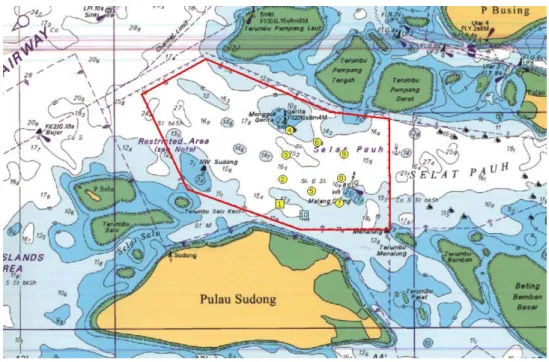
Experiments were conducted in a channel known as Selat Pauh in the Singapore Strait on January 14 and 21, 2009. Operational permits were secured from the Maritime Port Authority of Singapore (MPAS) and the operations of the vehicles were restricted to the area within a polygon with red edges as shown in Fig. 1.
FIGURE 1. Area of operation is within the red polygon. Points 1 to 10 are starting points and waypoints used in the tests.
In total, three Autonomous Surface Craft (ASC) were available for deployment. The ASC (3 meters long and 0.8 meters wide) are able to work at operational speeds of maximum 2m/s at full load for 3 hours, and are controlled by the computers mounted in the hull, either through a remote controller wirelessly or via installed control programs operating autonomously to achieve certain objectives. To differentiate each ASC, they are labeled as ‘blue’, ‘red’ and ‘white’. For example, a red kayak in operation is shown in Fig. 2.
Two of the ASC, the blue and red ASC, were mounted with paddlewheel sensors while the white ASC was mounted with a Doppler Velocity Log (DVL). The paddlewheel sensor (AIRMAR model 235DST-PSE) measures the speed of ASC with respect to the water in the centerline direction of the ASC. Global Positioning Systems (GPS) and compasses were mounted on all three ASC to track and control the movement of the ASC and measure the heading of the ASC, respectively. With the measurements from the GPS, compasses and paddlewheel sensors, the velocity of the surface current can be estimated. The GPS (Garmin model 18x) has an accuracy of up to 3m and a sampling frequency of 5Hz. The compass (Ocean Server model OS5000) measures the azimuth angle up to an accuracy of 0.5o.
Construction of Objective Function Map for the Design of Field Experiments
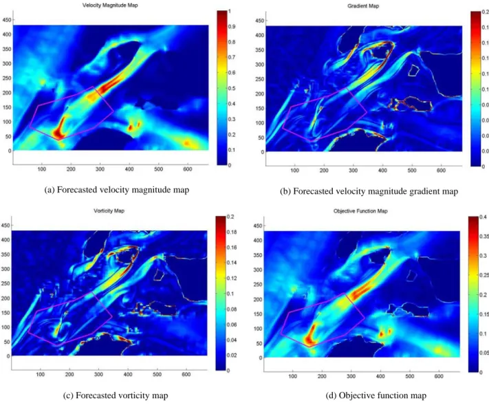
The design of our experiments relied on the forecast of various oceanographic parameters such as current speed, its gradient, and vorticity in the above mentioned region of interest and for time intervals that correspond to strong tidal currents. For example, maps of the above parameters at 1252 SST on January 14, 2009 are shown in Figs 3(a-c).
(a) Forecasted velocity magnitude map (b) Forecasted velocity magnitude gradient map
(c) Forecasted vorticity map (d) Objective function map
FIGURE 3. Objective function map and its constituents. The area of operation is within the magenta polygon.
An objective function map is generated by combining the above three parameters with appropriate weights. The objective function of exploration can be expressed as:
]
,
1
[
],
,
1
[
,
, 3 , 2 , 1 ,W
G
V
i
M
j
N
F
i j=
α
i j+
α
i j+
α
ij∈
∈
(1)0
,
1
3 1≥
=
∑
=α
α
k k k (2)where
F
i,j is the objective function value at point (i,j);
W
i,jis the normalized kinetic energy, as represented by the square of the current speed at point (i,j);G
i,j is the normalized magnitude of the gradient of the current speed at point (i,j);
V
i,j is the normalized vorticity at point (i,j);α
k is the weight of respective constituent, where k = 1,2,3;
i,
j
is the coordinates of computational grid in the oceanographic model;M ,
N
is the number of grid points in i,j direction, respectively.The kinetic energy, magnitude of the gradient and vorticity are normalized by the respective maximum value within the map. The objective function value at a single point on the map, Fi,j, is derived from the forecasted current
speed, its gradient, and vorticity. A region with greater value of Fi,j can represent a dynamical hotspot with
interesting features, which makes it more desirable for the ASC to visit the region.
The corresponding objective function map, which is a collection of all the points of the objective value, is shown in Fig. 3(d). With the objective function map, path planning for adaptive sampling can be carried out [3,4]. In our example, the weights
α
k are set to be equal for all three components but adjustments can be made accordingly, depending on different flow features of interest in the region. Utilizing this objective function map, our autonomous vehicles were allocated to effectively capture the oceanic features resulting from jets and vortices behind the islands in the tidal current.In the drifting test, the ASC were deployed from a controller ship one by one and were driven under power to their designated starting position. Once all the ASC were in their designated starting positions, the power to their engines was cut simultaneously for the ASC to start drifting along with the current. In the upstream test, two waypoints were chosen such that the ASC traversed between these two points, and the trajectories of the ASC were nearly parallel and opposite to the forecasted current stream.
Starting Points of Drifting Test
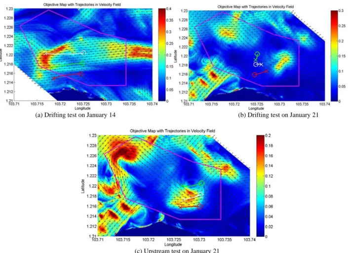
The drifting tests were conducted on January 14 and 21, 2009. On January 14, the currents were forecasted to flow from east to west during the test period as shown in Fig. 4(a). Hence, the starting positions of the three ASC were selected to make sure the ASC drift through the region of higher interest, while at the same time enabling the three ASC to explore the regions of different flow characteristics. The white kayak on the top was designed to drift to the region with highest objective value and the red kayak on the bottom was designed to drift to the region outside the features of interest. The blue kayak in the middle was designed to capture the possible boundary of the jet feature. The three starting points of the drifting test are represented by circles, as shown in Fig. 4(a). With reference to Fig. 1, the starting point of the red/white/blue kayak in the drifting tests on January 14, 2009 is waypoint 1/3/2, respectively. On January 21, the current was forecasted to flow from west to east during the test period as shown in Fig. 4(b). We noticed two major hotspots within the region of operation, mainly due to the persistent eddies generated by uneven topography. The starting positions of the ASC were selected in-between to observe the corresponding flow characteristics - see the three circles shown in Fig. 4(b). With reference to Fig. 1, the starting point of the red/white/blue kayak in the drifting tests on January 21, 2009 is waypoint 1/2/3, respectively.
(a) Drifting test on January 14 (b) Drifting test on January 21
(c) Upstream test on January 21
FIGURE 4. Designed starting (and waypoints) and the resulting trajectories. The permitted area of operation is demarcated by
the magenta polygon. The background color stands for objective function map. The trajectories of the drifting test on January 14 and 21 are shown in (a) and (b), respectively. The circles represent the starting points and the ‘x’s mark the termination points. The upstream test for January 21 is shown in (c). The circles represent the starting points and the ‘x’s are the waypoints for the ASC. The white circle/cross/line corresponds to white kayak, the green circle/cross/line corresponds to blue kayak and the red
circle/cross/line corresponds to red kayak.
Starting Points and Ending Points of Upstream Test
The upstream test was conducted on January 21, when the current was forecasted to flow from west to east during the test period. Hence, the starting positions and waypoints of the ASC were selected such that the ASC travel through the regions of higher objective function value and yet be nearly aligned to the direction of the current and nearly opposite to it, as shown in Fig. 4(c). The requirement for the alignment of the current vectors was due to the limitation of the paddlewheel sensor to be only able to measure the speed of ASC with respect to the water in the centerline direction of ASC.With reference to Fig. 1, the starting point of the red/white/blue kayak in the upstream test on January 21, 2009 is waypoint 7/8/9, respectively, and the ending point is waypoint 1/2/3, again respectively.
EXPERIMENT RESULTS AND DISCUSSION
Drifting Test
The kayak trajectories of our drifting test on January 14 are shown in Fig. 4(a). The paths of the three ASC describe their drifting along the predicted east-to-west current flow. As planned, the white kayak explored the region
with higher objective function values along its trajectory, while the red kayak kept drifting along the region outside of the meandering jet.
The kayak trajectories of our drifting test on January 21 are shown in Fig. 4(b). Even though the initial plan was to let the ASC drift into the region of high objective function values, the goal was not completely achieved due to the difference in the actual and forecasted currents. The paths of the white and red ASC describe their drifting along the predicted west-to-east current flow. However, the blue ASC displayed an unexpected behavior by drifting towards a south-south-westerly direction. The authors proposed a hypothesis [5] that the predicted topographic eddy can account for the unexpected behavior of the blue ASC, although the simulated phase of the vortex shedding does not exactly coincide with the measurement. Work to carry out data assimilation using data collected to improve the prediction of the tidal current field is ongoing.
Upstream Test
The kayak trajectories of our upstream test on January 21 are shown in Fig. 4(c). The paths of the three ASC describe their upstream movement against the predicted west-to-east current flow. The three kayaks explore the region with high objective function value along their trajectories as planned. Further discussion on the measured and forecasted velocity field can be found in [5].
CONCLUSIONS
The design process of the field experiments to explore significant oceanographic features in the Singapore Strait is discussed. Three ASC were used to conduct drifting and upstream tests on January 14 and January 21, 2009. The planning of the experiments was based on the forecast of the velocity field in the Singapore region done by TMSI of NUS. Results of the drifting test of January 14 and the upstream test of January 21 agree well with the predicted tidal current field. The blue ASC displayed an unexpected behavior in the drifting test of January 21 and possible hypotheses for this phenomenon have been studied. Data assimilation would further assist in improving the ability of computational models to accurately identify the field with interesting oceanographic features.
ACKNOWLEDGMENTS
The research described in this paper was funded in whole or in part by the Singapore National Research Foundation (NRF) through the Singapore-MIT Alliance for Research and Technology (SMART) [6] Center for Environmental Sensing and Modeling (CENSAM) [7].
REFERENCES
1. Da Guo, Constantinos Evangelinos, Nicholas M. Patrikalakis, "Flow Feature Extraction in Oceanographic Visualization," Proceedings of Computer Graphics International 2004 (CGI'04), IEEE Computer Society 2004, pp.162-173.
2. W.C. Pang, P. Tkalich, and E.S. Chan, "Hydrodynamic forecast model for the Singapore Straits", Proceedings of the XXX IAHR Congress, Thessaloniki, Greece, August 2003, A: 9-16.
3. N. K. Yilmaz, C. Evangelinos, P. F. J. Lermusiaux, and N. M. Patrikalakis, "Path Planning of Autonomous Underwater Vehicles for Adaptive Sampling Using Mixed Integer Linear Programming", IEEE Transactions, Journal of Oceanic Engineering, Vol. 33, No. 4, pp. 522-537, October 2008.
4. N. K. Yilmaz, "Path Planning of Autonomous Underwater Vehicles for Adaptive Sampling", Ph.D. thesis, Massachusetts Institute of Technology, September 2005.
5. B. H. Ooi, H. Zheng, H. Kurniawati, W. Cho, M. H. Dao, J. Wei, P. Zemskyy, P. Tkalich, P. Malanotte-Rizzoli, N. M. Patrikalakis, "Multi-vehicle Oceanographic Feature Exploration", Proceeding of ISOPE 2009, Osaka, Japan, June 2009. 6. SMART, http://web.mit.edu/smart/