DESIGNING A FIELD EXPERIMENT FOR ASSESSING SOIL AND CROP SPATIAL VARIABILITY AND DEFINING SITE-SPECIFIC MANAGEMENT STRATEGIES.
M. GUÉRIF(1), N. BEAUDOIN, C. DURR , V. HOULÈS , J.M. MACHET, B. MARY,
S. MOULIN(1), G. RICHARD
INRA Unité d’Agronomie - Rue Fernand Christ - 02007 Laon Cedex
(1) present adress : INRA Unité Climat, Sol et Environnement – Domaine Agroparc – 84914 Avignon Cedex 09
C. BRUCHOU
INRA Unité de Biométrie - Domaine Agroparc – 84914 Avignon Cedex 09 D. MICHOT, B. NICOULLAUD
INRA Unité de Science du Sol– 45166 Olivet Cedex
ABSTRACT
A research program is undertaken which aims at defining site specific management strategies concerning nitrogen fertilisation and further soil tillage and seedbed preparation. The methodology is exposed; it consists firstly in the acquisition of information on spatial variability of soil and crop characteristics. The second step consists in elaborating a diagnosis from this information, either by the way of indicators, or by using crop models. A field experiment was designed as support to this program. The preliminary results of the research are exposed : spatial distribution of soil characteristics, and crop emergence by means of geostatistics, crop status (LAI, chlorophyll content) quantification from remote sensing data, elaboration of crop nitrogen nutrition indicators from these crop variables, test of the ability of a crop model to describe within field crop growth variability.
INTRODUCTION
Many technological advances have been made in the last decade: global positioning systems, various sensing systems, data exchange, computing, variable application technology. These advances make it possible to take into account the spatial information in husbandry decisions, leading to the concept of precision agriculture (Robert, 1999).
One component of precision agriculture concerns relating crop management to site specific conditions in the soil and of the crops. This should enable agriculture to be more able to meet agri-environmental constraints.
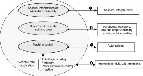
Different levels of knowledge and skill are necessary to develop precise cultural practices (Fig. 1). The first level is the description of the spatial variability of soil and crop which is the basis of all further developments. Sensors and associated interpretation models have been developed in geophysics, detection by vision, remote sensing, yield mapping. Among these, remote sensing is a powerful tool which provides timely spatial information on various soil and crop characteristics (Guérif et al, 2001). These characteristics should provide a basis for diagnosis and decision making at the second level, that concerning agronomy. It is reasonable to assume that all the current agronomic knowledge should be used and adapted to define
methods and rules for site specific agriculture. The third level concerns the technology of variable application for different cultural practices and refers to skills in automatism and the control of machines. A fourth level of skills is required which concerns computer science and data processing: the combination of multiple sources of data and the automation of the whole process, from sensing to application. The data must be easily available, and geographically referenced in a GIS database, and stored in convenient databases.
Acquiring these skills means collaborating with different teams, and if possible at a common site. We wanted to do this at a site with four teams to assess soil and crop spatial variability and to define site specific management strategies for nitrogen fertiliser application. The research described refers to the first two levels of the previous schema, to first examine the methodological feasibility of site specific crop management.
FIGURE 1. The different skills to gather for handling within-field variability into cultural practices
METHODOLOGY
For nitrogen fertilisation, the operational methods used at the field level to diagnose N requirements are based on soil and plant indicators (soil mineral nitrogen content, stem nitrate concentration, SPAD measurements) deduced from a few measurements within the field. A site specific management method may be a generalisation of the ‘at field level’ method, which depends on characterising the within-field spatial variability of soil and crop indicators, and on deriving indicators from new sensor capabilities (Fig.2, o). One of the limitations of indicators is that they might express the result of interactions between different limiting factors (e.g. N limitation x water limitation) and lead to the wrong diagnosis and the wrong recommendations.
Site specific management may be achieved by the development of a new method which avoids this limitation, and which is based on the use of a crop model driven by remote sensing data (Fig.2, p). A crop model is well adapted for making a diagnosis on the current status of the soil and crop everywhere in the field, as soon as the information (initialisation, description of entry variables,…) is available. Some physical characteristics of the soil (physical and
Sensors, interpretation models
Automatisms
Informatique (IDE, GIS,database, )
Soil tillage / sowing Fertilizers
Pests and weeds control Irrigation
Variable rate application
Agronomy: indicators, soil and crop functioning models, decision making
q
n
o
p
Sspatial informations onwithin field variability
Rules for site specific soil and crop
t
chemical characteristics) are potentially available from classic methods (soil map, soil sampling and laboratory analyses) or new sensors (geophysics) but some others are not available (interaction between plant and soil like rooting depth, root elongation rate, …). With remote sensing it is possible to retrieve information on crop characteristics (LAI, chlorophyll content) which can be used to “control” the model. By forcing the model to simulate values close to the remotely sensed ones, a process called assimilation of remote sensing information into the model (Guérif and Duke, 1998, Moulin, 2001), it is possible to retrieve the spatial distribution of some of the unknown variables, and to inform the crop model correctly everywhere in the field. The model can then be used to make a diagnosis on various aspects of
FIGURE 2. From measurement to recommendation : n from measurements to soil and crop variables; from soil and crop variables to recommendation through indicators o or models p.
the crop status (plant nitrogen content, available nitrogen in the soil, organic mater status in the soil, water stress index,…). Decision rules can therefore be applied (the model can be used also to derive the rules or refine the existing ones).
Our aims are to evaluate both methods described above (indicators and models), with the following methodology :
∗ Describing the within-field variability of soil and crop characteristics. We were interested in soil permanent characteristics for depicting its water retention capacities, but also in mineral N content (SMN), organic matter, and water content, as input variables in the crop model. We were also interested in characterising crop status in terms of growth (results of emergence, LAI, yield) and nitrogen status that we derived from chlorophyll content (Cab). Both LAI and Cab are available from remote sensing measurements in the solar domain thanks to radiative transfer models inversion (Baret and Fourty, 1997).
∗ Developing crop indicators from crop characteristics available from remote sensing (LAI and chlorophyll content). The aim is to determine whether these two variables allow the nitrogen status of a crop to be evaluated by reference to the Nitrogen Nutrition Index NNI (Lemaire et al, 1997) which is a reference method.
∗ Evaluating the ability of the chosen crop model, STICS-blé (Brisson et al, 1998), to reproduce crop spatial variability. As a first step, the aim is to calibrate the model with few locations with different soil conditions, and then to validate it on a larger number of locations.
THE EXPERIMENT
Two contrasting fields (10 ha each) of an arable farm have been chosen near Laon (Picardie, France) where winter wheat has been grown every year. In the first year the spatial variability of the permanent properties of the fields was characterised: topography, high-resolution soil mapping with both conventional and geophysical methods (Michot et al, 2001) that can be compared to high-resolution spectral images. Sampling of the plough layer was on a regular grid (82 points, 36 m spaced) and four crosses in order to investigate short distance heterogeneity (see Mary et al in the same issue) (Fig 3). This scheme was also used for measuring water and nitrogen profiles down to 150-cm depth at three dates in the growing season (sowing, end of winter, harvest). Seedbed, crop emergence characteristics and growth variables (LAI, nitrogen content and yield) were observed at selected points on a subsample of this grid during the crop cycle. Remote sensing images (hyperspectral visible and near infrared domain) were taken from airborne measurements at four dates, from March to June, to provide information on crop growth status (LAI, chlorophyll content) (see Moulin et al in the same issue). On the ground, measurements of LAI and Ncontent were done either on the
FIGURE 3. The experimental sampling design : regular grids (+ 82 points, o 22 points) and four crosses (placed nearby the 4 microplots for model calibration.
complete grid, or on a subsample of it (22 points). At harvest, yield mapping was performed as well as ground control yields on the grid points (see Machet et al in the same issue). Two additional experiments were set up in the field: 1) six microplots receiving varied N fertiliser rates (0-300 kg N ha-1) aimed at evaluating nitrogen nutrition indicators based on
leaf area index and chlorophyll content (see Houlès et al in the same issue); 2) four microplots on different soil zones were set up to calibrate the crop model that will be used for designing new decision making tools (see Beaudoin et al in the same issue).
PRELIMINARY RESULTS
The first stage of the study, has been one of data acquisition for the first two years of the project, to characterise the soil of the fields.
The results include soil map definition using conventional and geophysical data, geostatistical analyses on soil data (see Mary et al in the same issue), inversion of remote sensing data to retrieve canopy biophysical variables (see Moulin et al in the same issue), elaboration of nitrogen nutrition indices from these variables (see Houlès et al in the same issue), validation of the yield map (see Machet et al in the same issue), evaluation of the crop model performance for assessing the within field variability (see Beaudoin et al in the same issue). The results demonstrate the possibility of linking N nutrition indices to biophysical variables, such as LAI and chlorophyll content through empirical relationships, even if such relationships have to be reinforced with more data. The value of remote sensing in the solar domain, which gives access to such biophysical variables, is confirmed. Concerning the evaluation of the crop model, it was shown that when correctly initialised and calibrated, especially with respect to the maximal rooting depth, the model correctly reproduced the crop growth and yield. These results point out the importance of being able to calibrate the model everywhere in the field. This possibility, as well as that of initialising the model everywhere, is enabled by the use of remote sensing which allows us to constrain the model and, by assimilation of the data into the crop model, to re-estimate some variables that are difficult to determine by other means. The use of yield maps, obtained over several years for the same field, might allow us to acquire valuable knowledge on some of the permanent characteristics of the field. The yield maps can be used to inform the crop model in such a way that it can correctly represent the within-field variability of crop development. Once informed, the crop model will represent a valuable tool for diagnosis and decision making. These aspects will be tackled in the next developments of the project.
REFERENCES
Baret F., Fourty T. (1997) Radiometric estimates of nitrogen status of leaves. In : Diagnosis of the Nitrogen Status in Crops, Chapter 1, G. Lemaire (ed) © Springer-Verlag Berlin Heidelberg 1997.
Beaudoin N., Delerue J.B., MachetJ.M., Mary B. (2001) Analysis of spatial variability of winter wheat yield within a field using a crop model. In : Proceedings 3rd European Conference on Precision Agriculture, June 2001, Montpellier (FRA).
Brisson N., et al (1998) STICS: a generic model for the simulation of crops and their water and nitrogen balance. I. Theory and parameterization applied to wheat and corn. Agronomie, 18: 311-346.
Guérif M., Duke C. (1998) Calibration of the SUCROS emergence and early growth module for sugarbeet using optical remote sensing data assimilation. European Journal of Agronomy, 9 : 127-136.
Guérif M., Baret F., Moulin S., Bégué A. (2001) Prise en compte de l’hétérogénéité parcellaire et de son évolution temporelle dans la gestion des interventions techniques : potentiel de la télédétection. In : Modélisation des agro-écosystèmes et aide à la décision, E. Malézieux (ed), collection Repères, CIRAD, Montpellier (FRA).
HoulesV., Guérif M., Mary B., Machet J.M., Moulin S. (2001) Do crop characteristics available from remote sensing allow to determine crop nitrogen status ? In : Proceedings 3rd European Conference on Precision Agriculture, June 2001, Montpellier (FRA). Lemaire G. and Gastal F. (1997) N Uptake and Distribution in Plant Canopies. In : Diagnosis
of the Nitrogen Status in Crops, Chapter 1, G Lemaire (ed) © Springer-Verlag Berlin Heidelberg 1997.
Machet J.M., Boffety D., Van Laethem C., Bernard M., Beaudoin N. (2001) Characterization of the variability in grain production and quality within a winter wheat field . In : Proceedings 3rd European Conference on Precision Agriculture, June 2001, Montpellier (FRA).
MaryB., Beaudoin N., Machet J.M., Bruchou C., Aries F. (2001) Characterization and analysis of soil variability within two agricultural fields : the case of water and mineral N profiles. In : Proceedings 3rd European Conference on Precision Agriculture, June 2001, Montpellier (FRA).
Michot D., Dorigny A., Nicoullaud B., Benderitter Y., 2001. Precision irrigation management : determination of water flow direction and corn roots induced drying using electrical resistivity measurements. In : Proceedings 3rd European Conference on Precision Agriculture, June 2001, Montpellier (FRA).
MoulinS., KergoatL., Cayrol P., DedieuG., PrévotL. (2001) Using a coupled canopy functioning and SVAT model in the ReSeDA experiment. Assimilation of SPOT/HRV observations into the model. Physics and Chemistry of the Earth (accepté).
Moulin S., Guérif M., Machet J.M., Baret F. (2001) Assessing the within field spatial variability of crop growth status by remote sensing for site specific N fertilization management. In : Proceedings 3rd European Conference on Precision Agriculture, June 2001, Montpellier (FRA).
Robert P. (1999) Precision Agriculture : Status and Research needs. In : J. Stafford (ed.). Proceedings of the 2nd European Conference on Precision Agriculture. 12-15 July 1999, Odense, Danemak. SCI, London (U.K.).