1
Urban Densification through Roof Stacking: Case Study
Mohamed Amer
Sustainable Buildings Design Lab, Urban and Environmental Engineering Department, Faculty of Applied Sciences, Université de Liège, Belgium
e-mail: [email protected]
Sigrid Reiter
Local Environment Management & Analysis, Urban and Environmental Engineering Department, Faculty of Applied Sciences, Université de Liège, Belgium
e-mail: [email protected]
Shady Attia
Sustainable Buildings Design Lab, Urban and Environmental Engineering Department, Faculty of Applied Sciences, Université de Liège, Belgium
e-mail: [email protected]
Abstract
Nowadays, major European cities witness one of their greatest challenges in history. Increasing migration from the rural areas, not to mention the massive migrations from the east, contributes in aggravating the challenge. As a response, United Nations urban agendas promote for developing urban spatial frameworks based on appropriate compactness, polycentrism and mixed use, preventing urban sprawl and marginalization. In this research, a methodology is presented that aids the decision making on roof stacking as a sustainable approach towards urban densification. Brussels Capital Region in Belgium is chosen as a case study to represent the outcomes of a methodology that has been developed to identify urban densification potential through roof stacking. Further applications to generalize the approach to fit other cities in Europe would help create additional opportunities to develop an automated tool for estimating such potentials on a wider scope.
Keywords: Roof extension, Lightweight construction, Circularity, Retrofitting, Brussels
Introduction
Rapid urbanization and urban sprawl phenomena have occurred due to population growth, globalization and European integration, increasing land price accompanied with inner city problems. (Vasili, 2013). As a result, urban footprint and levels of CO2 emissions have increased significantly in the last decades. One key indicator that measures the sprawl effect is the Urban Morphological Zones (UMZ). UMZ is defined as the built-up areas lying less than 200 meters apart. They are made up of four different land cover classes; either is it continuous urban fabric including buildings, roads, and artificial surface areas covering almost all the ground or discontinues urban fabric with artificial surface partially covering the ground, or industrial or commercial units, or the last type which is defined under the green urban areas where vegetation patches can be found within urban fabric. The rectangle shown in Figure 1 refers to the axis known as the European Megalopolis, which runs from London and Birmingham in the UK passing by Paris and Lille in northern France, Belgium, Netherlands, Dusseldorf, Cologne and Bonn in Germany till it reaches northern Italy at Milan and Turin (EEA, 2011).
2
Figure 1: Urban morphological zones. Source: (EEA, 2011). Edited by Authors
Several governments in Europe attempted to limit urban sprawl through manifold and integrated urban growth management strategies, bringing together municipalities, civil society, business and economy. On the urban planning level, Pendall, Martin, & Fulton (2002) classified urban containment strategies into three major forms; Green belts, Urban Growth Boundary (UGB) and Urban Service Boundary. However, each containment strategy has its drawbacks that create a counter effect in another aspect in urban and regional planning development. Thus, a holistic approach that consists of densification strategies is necessary to limit urban sprawl and to sustain containment strategies. Urban agendas proposed by the EU draw the line for urban development and spatial frameworks. These frameworks aim to achieve more sustainable land use management based on appropriate densification, polycentrism and mixed land use through infill development and land use management to prevent increased urban sprawl and marginalization (United Nations, 2017). Several approaches and strategies are followed to reach the targeted goals and achieve compactness and more dense cities. One approach that has been increasingly followed in the recent years is through building on the rooftops, or roof stacking.
Even though roof stacking is taking place in many cities around Europe, the definition of “Roof Stacking” was found to be lacking in the English literature. However, there were barely a couple definitions for its equivalent in the German literature. The first definition found for “Aufstockung” or “Roof Stacking” described it as “A structure that is constructed upon the top floor space - generally the roof - of an existing building, adding one or more stories” (Floerke, et al. 2014). The second definition was found to be similar to the first one. The second definition has been translated from German to English in this research to be as following: “Creating new living spaces, with one or more additional stories, with flat roofs on the roof surface or gable roofs on the top floor ceiling” (Tichelmann & Groß, 2016). Thus, it is obvious roof stacking as a topic is still needed to be investigated on multiple scales. In this research, roof stacking on the urban scale is being investigated.
3 The lack of existing tools that measures cities’ capacity to increase their densities is the motivation behind developing a methodology and a framework to identify the potential for urban densification specifically through roof stacking. This article presents the results of a research that has been done by the same authors (Amer, et al. 2017). The developed methodology aims to provide a fast-track measurement for decision making on increasing urban density on different levels, such as cities, suburbs, and neighbourhoods. Thus, it does not substitute the need to carry out deep investigations for building by building when it comes to onsite implementation. The decision making is based on three consecutive levels: urban, engineering and architectural.
Criteria have been set to measure and map the potential for roof stacking and to give the guidance to urban planners and decision-makers to create development strategies based on quantified results. The significance of this research lies in the creation of a generic approach that relies on utilizing information and GIS database to quantify and evaluate the potential to increase urban density by roof stacking. Throughout the quantification process, maps are generated to identify the location of roof stacking potential. The article is organized under three main sections. The first section defines the boundary conditions represented in the case study. The second section presents the workflow and mapping criteria. In the third and last section, mapping results and the quantified roof stacking potential in Brussels Capital Region (BCR) are presented with an eye towards promoting for sustainable urban densification in European cities.
Brussels Capital Region (BCR)
Housing and population
In this research, the study of urban densification potential has been investigated on a European scale, taking in consideration the generic context and configurations of European cities. Thus, Brussels Capital Region has been chosen as a case study representing the capital city of Europe. Brussels has been the fastest growing city in terms of population compared to other Belgian cities. The increase in population is expected to reach 190,000 inhabitants by the year 2040 (Deboosere, 2010; Paryski & Pankratieva, 2012). There are two main reason behind this phenomena that dates back to the 90s. The first reason is due to the first wave of international migration. The second reason is due to the reinvigoration of birth rate in the last decades. As a result, the population of Brussels has increased by over 220,000 inhabitants in the last 20 years, with an increase in the number of households that reached 75,000 units (Van de Voorde, et al. 2015). As a result of those increases, the average population density has reached more than 66 inhabitants/ha, including non-constructible areas. Whereas the actual densities of the neighbourhoods in Brussels varies from one to another. The highest urban density reaches up to 362.43 inhabitants/ha dominated by the middle and low income socioeconomic groups, while the lowest density reaches 2.64 inhabitants/ha dominated by higher income socioeconomic groups.
There are several housing projects that took place to overcome the increase of population in Brussels. On an annual rate, there are around 5000 houses that are being built. Those houses serves three different categories. The first category is made for public housing, which occupied 10% of the housing units share. 15% of the social houses consist of rentable housing for low income households. However, those rentable houses are usually accompanied by long waiting period to obtain those houses. The other 85% of the social houses are subsidised, based on a maximum cost of 1500 euros per square meter, which targets middle income households. The second category of the housing projects takes a share of 70% housing units. Those houses are given to the private market and built by private developers. While the remained 20% are given directly for private ownership (Dessouroux et al., 2016).
According to those statistics, the low- and middle-income socioeconomic classes have a severe shortage in housing provision. This shortage creates a pressure on the government to provide more houses for those social tiers and changing their housing policies (Decker, 1990; Decker 2008). However, there are several reasons behind this shortage in public and social housing. The first reason is due to the limited amount of public land that can be used for public housing. While the second reason is due to the fact
4 that the given houses designs are only appropriate for higher economic classes. Additionally, land prices inside Brussels are relatively very high compared to the peri-urban areas. As a response to this shortage and those circumstances, the Royal Decree “Urban Planning Charges” forces new regulations that oblige the government to assign 30% of the new developments for social housing. Those regulations are considered to be an attempt to overcome the housing crises in Brussels Capital Region, whereas on ground practices could represent a real challenge during implementation, such as the NIMBY “not in my back yard” effect, which puts local communities in charge when it comes to new development projects. Accordingly, it is important to find practical alternatives that presents win-win situation for existing households with those who seeks housing and the government.
Housing Typologies
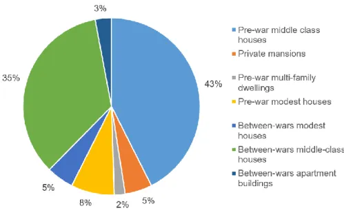
This research aims to promote roof stacking as a sustainable approach towards reasonable urban densification and provision of more houses to accommodate increasing population. One housing typology has been selected to examine the developed methodology that defines the potential for roof stacking on a city scale. In this research, existing residential buildings in Brussels Capital Region are divided into two categories according to the period of construction: residential buildings that were built before the year 1945, and those were built after. The year 1945 marks the end of the Second World War, WWII, and the beginning of a new period in the field of building and construction. In this research, the houses built before WWII are concerned for the densification process. There are several reasons behind choosing those houses. The first reason is due to the unity in architectural layout and structural configurations of the existing buildings. Thus, with limited information in the GIS database, adequate estimations for roof stacking potential could be calculated as it will be discussed briefly in the coming sections. The second reason is because the majority of the existing buildings in Brussels Capital Region are built before WWII, which represent 71% of the existing residential buildings. Under this period, there are several housing typologies that are used to be built, such as middle-class, multi-family, and modest houses. Each typology is different in terms of architectural configurations and scale. The majority of the houses built before the WWII were middle-class houses, which represents 78% of the given typologies as shown in Figure 2, which are examined in this research.
Figure 2: Different typologies for residential buildings built before and in-between the wars Source: (Amer et al., 2017)
5
Mapping criteria and boundary conditions
In order to ensure a high level of sustainability when estimating the densification potential through roof stacking, several aspects have to be considered related on the urban level such as the existing policies, accessibility to transportation, accessibility to parking areas and green spaces, maximum allowable building height and the right to light. Those aspects are being discussed briefly as following.
First level of mapping: urban & policies configurations
Heritage buildings
In Brussels Capital Region, there are five sites that are under the protection of UNESCO. Thus, densification and urban intervention is severely limited in those sites. Under those site, various zones are subjected to strong heritage protection. For those zones with strict protection, roof stacking has been totally excluded from the densification and mapping process. In contrary, the zones with less strict protection are included in the calculation of densification potential.
Accessibility to transportation
Mobility and accessibility to existing city’s transportation represents an important challenge and vital need when it comes to all form of densification. Population increase together with proper provision of public transportation and soft mobility networks should assist Brussels Capital Region to go on board with the transition towards sustainable modes of transportation. The strong network of transportation in Brussels could absorb the expected increase in population (COOPARCH-RU, 2013). Areas that are located within a radius of 600 meters around the primary public transportation network and stops such as metro and train station, in addition to areas within 400 meters around tramways network and stops cover more than 60% of the whole area of Brussels Capital Region. The rest of the area are covered with a large number of bus stops. In addition to a reasonable amount of reinforced soft mode network of transportation, such as those for walking, bicycle, and electric bikes, would have a huge impact in the overall transportation network, given that urban densification would shorten the average destination needed between home and work. Accordingly, almost all areas in Brussels Capital Region have an access to transportation and therefore were included in the mapping of the densification potential.
Accessibility to parking areas
In the low density neighbourhoods and peripheral areas in Brussels, it is easy to provide more parking plots for the roof stacked buildings. However, in more dense areas in the city, it become more challenging to provide additional parking areas for more inhabitants. Establishing a car park could be managed on a case by case basis. Nevertheless, there is a great potential to increase parking spaces to meet the projected densification demand, if additional parking spaces are built over existing open-air car parks. Currently, the number of existing car parks located in Brussels Capital Region reaches 9425 different parking areas according to the Ministère la Région du Bruxelle Capital (MRBC) (COOPARCH-RU, 2013). There are 325 out of the 9425 parking areas with an area more than 1000m2. An area of 1000m2 has the potential to hold 50 cars, using an average area of 20m2 per car (this area includes the traffic infrastructure between parking spaces). In addition, an area of 1000m2 represents a realistic area with a potential to be raised up. Parking areas with more than 1000m2 cover a total area of 68,681m2 on a single level in Brussels. Thus, there is a huge potential to increase parking areas in Brussels to cover the potential increase of population by roof stacking. Finally, a formal shift to carpooling and public transportation together with soft mobility should be encouraged. Accordingly, there was no building that has been excluded in the mapping process during the calculation of roof stacking potential in Brussels on the basis of lack of accessibility to parking areas.
6 Accessibility to public green spaces
In Brussels Capital Region, there are nearly an area of 4,000 ha of green spaces, which represents an approximate of 25% from the whole territory, which is equivalent to 36m2 of green spaces per inhabitant (COOPARCH-RU, 2013). This ratio exceeds more than three times the minimum recommended value, which is equivalent to 10m2 of green spaces per inhabitant (De Herde, et al. 2009). Accordingly, the population of Brussels could be tripled without the need for provision of additional green spaces. Therefore no building in the Brussels Capital Region was excluded from our mapping process of the roof stacking potential in Brussels on the basis of a lack of accessibility to green spaces.
Maximum allowable building height
According to the current urban regulations, the maximum height of the front façade could be determined by the height of the two neighbouring buildings. The height of the façade cannot be less than the lowest or more than the highest reference height of the neighbouring buildings. In addition, it cannot be more than 3 meters above the lowest reference height. Another method of determining the maximum allowable height of a new roof or roof stacked building is by determining the mean average height of the rest of the buildings in the same street. The latter has been used in the mapping process for simplicity, which corresponds to the existing urban regulations.
Accessibility to daylighting
The “right to light”, or accessibility to daylighting is one of the most important aspects that has to be taken in consideration to achieve sustainable urban densification. There is not well-defined regulation imposed in the city of Brussels that ensures an adequate access to daylight, which is obvious in the centre of the city, where tall buildings are juxtaposed next to each other’s. However, in the mapping process for a sustainable densification, the right to access daylighting has been taken in consideration. The calculations have counted on the recommendations, given for the same latitude of Brussels, made by international research. The acceptable limiting obstruction angle was found to be equal to 25° taken from a height of 2 meters above the street level on the facing building façade (Littlefair et al., 2000). Accordingly, the maximum height could be identified by knowing street widths.
Second level of mapping: structural configurations of buildings
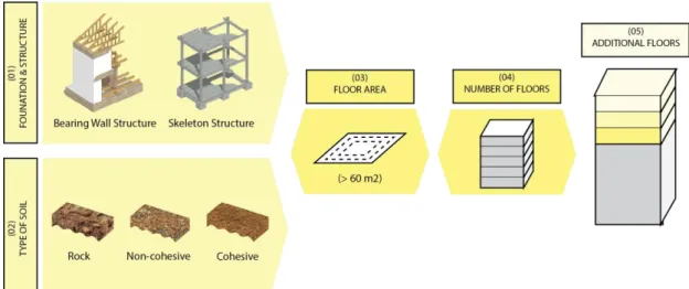
The state of art that lies in the developed methodology lies in applying primary structural analysis on the urban level in order to strengthen the mapping process giving a higher level of precision. The information required to estimate the structural capacity of the existing buildings to hold more weight varies from identifying the structural configuration, soil properties, area of the building and existing number of floors as following as shown in Figure 3.
Building typology
The typical layout of a middle-class house as explained in a previous section. This typology has been selected to facilitate the mapping process and since that it represents the majority of existing houses. Accordingly, building structural configurations and materials have been referenced (Van de Voorde et al., 2015). According to this reference building, the average weight of the walls has been given an estimate of 1900 kg/m2, while the weight of the given roofs and slabs are estimated to be 100 kg/m2. Live loads are given a constant value of 200 kg/m2.
7 Soil allowable bearing capacity
The soil map of Brussels Capital Region has been obtained and integrated with the whole mapping process. There are seven types of existing soils with different bearing capacities. For simplification, the region is divided into two parts. The dominant soil which is located at the upper part of the region consists of sandy sediments, while the lower part consists of silt sediments. Accordingly, the allowable bearing capacity of the existing soil ranges between 150 kN/m2 to 350 kN/m2.
Floor area and number of floors
In the GIS database, the data related to floor area and number of floors exist, which was beneficial in the calculation process. The available data is updated on a yearly bases by the cadastre administration in the Ministry of Finance in Belgium. According to this data, it has found that 99% of the residential buildings have number of floors that range between 1 and 5 floors. Thus, it is important to mention that the mapping process took place on building with no more than 5 stories, to avoid over densification. In addition, buildings with a minimum area of 60m2 has only been taken in the mapping process. The aim behind setting up a minimum threshold for the floor area is to exclude any imprecisions in the GIS database and to ensure that only the selected typology has been calculated.
Estimated weight added per square meter
Since roof stacking methods are selected in this research to identify densification potential, lightweight construction methods have been assumed as a prerequisite for roof stacking. Thus, a rough estimate for the total weight of construction has been identified with a maximum of 500 kg/m2 based on several literature (Amer & Attia, 2017; Lawson et al., 2010). However, different scenarios are examined to identify roof stacking potential with lighter weight of construction.
Figure 3: mapping process for structural configurations Source: (Amer et al., 2017)
8
Results
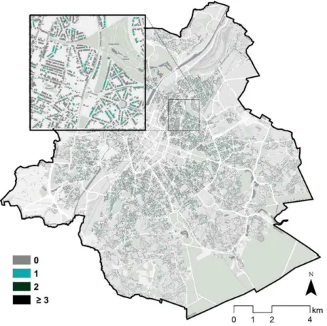
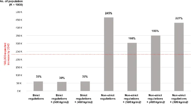
The mapping process has taken place using ArcGIS based on the previous information and developed methodology. The calculations in the mapping process have been made based on an estimate area of living space equivalent to 35 m2 per inhabitant. By adding the service areas such as stairs and hallways, which are equivalent to 9% of added space, the total floor area to accommodate one inhabitant is equivalent to 38.15m2. Several factors were found to be affecting dramatically the potential for roof stacking. Given that Brussels Capital Region consists of a core then two peripheral zones with lower densities, it has found that the highest potential for roof stacking was found in the first peripheral zone, respecting urban regulations and structural strength of the existing buildings. The reason behind this potential compared to the core on one hand lies in the fact that the core cannot be further densified. While on the hand, with the second peripheral zone, the average height of the buildings is quite low, which by consequence limits the potential to add floors on the neighbouring buildings. In this article, several scenarios have been proposed in order to provide further estimations on the potential for roof stacking without considering strict urban regulations or reducing the weight of the added floors. The first scenario shows the potential for densification when applying current urban regulations. This scenario is followed by another which considers an added weight of 500kg/m2 and 400kg/m2 of roof stacking. As a results, when applying strict urban regulations, as a first step, it was found that Brussels Capital Region has the ability to host more than 60,400 inhabitants, thanks for roof stacking, which is equivalent to 32% of the expected increase in population. In the second step, when considering actual building strength with added weight of 500kg/m2, the number is reduced to reach 59,000 inhabitants, which represents 30% of the expected increase in population as shown in Figure 4. This reduction is equivalent to only 2% from the first step. When reducing the added weight to 400kg/m2, the number is increased to reach the same value of the first step, which is equivalent to 32% of expected increase of population.
Figure 4. Roof stacking potential with respect to strict urban regulations & buildings strength Source: (Amer et al., 2017)
9 The second scenario presents the potential for densification with the less strict urban regulations. Less strict in this context would represent the elimination of the maximum allowable height based on the neighbouring buildings, while keeping maximum allowable height based on the right to light. Thus, more potential for roof stacking could be achieved while maintaining environmental aspects related to daylighting. As a consequent, the second scenario gives a higher potential for densification and increase the city’s capacity to accommodate more population in the coming years. Moreover, in the second scenario, several steps are taken in consideration. The first step estimates the absolute potential to accommodate population when applying less strict urban regulations and no consideration to structural capacity of the existing buildings. The other steps considers the structural capacity of the existing buildings to hold more weight of 500kg/m2, 400kg/m2, and 300kg/m2. When applying the second scenario of the mapping process, which includes less strict urban regulations, the potential for densification increases dramatically. It was found that Brussels Capital Region could host more than 655,500 inhabitants, which is equivalent to 245% of the expected increase in population. When adding the structural capacity of the existing buildings with an estimate weight of 500kg/m2, the potential for accommodate population is decreased to reach 509,000 inhabitants, equivalent to 160% of the expected increase, which remains 6 times higher than the first scenario. However, when reducing the added weight of roof stacking to 400kg/m2 and 300kg/m2, the increase reaches 185% and 227% respectively. In the second scenario, and within the distribution of the regions with higher potential for densification, it has found that the underlying soil has the greater influence on roof stacking. This influence is shown when applying the structural capacity of the existing buildings. Given then the eastern and southern areas of Brussels Capital Region consists of soil with higher bearing capacity, higher potential was found in the same areas. In contrary, in the northern and western areas of the region, the soil has lower bearing capacity resulting with lower potential for roof stacking. When comparing both areas of the region, the difference in roof stacking potential in the northern municipalities is 25%, whereas the difference reaches only 16% in the southern municipalities. It is important to highlight the fact that these results are based on selecting the housing typology with the same structural configurations, on which the area and number of floors remain the main influencers on the bearing capacity of the building apart from the soil bearing capacity.
Figure 5. The potential to accommodate the expected increase of population in Brussels Capital Region by 2040 under different roof stacking scenarios
10
Conclusion
Currently, United Nations urban agendas puts forward recommendations to achieve compact cities and reasonable densification as an approach towards achieving sustainable development. Based on these recommendations, this research aims to develop a methodology that determines the potential of a city to increase its density through roof stacking. This article has been developed in three phases. The first phase is concerned with identifying the case study and its boundary conditions. The second phase illustrates the criteria required for the mapping process. The third phase draws the outcome of the methodology through a map for Brussels Capital Region with the densification potential on a building scale. According to the mapping results, we found that Brussels has the potential to accommodate 30% of the expected increase of population by 2040, following the current urban regulations and buildings’ structural capacity. However, when applying less strict urban regulation, this potential increases to accommodate 160% of the expected increase in population in Brussels Capital Region by 2040. These results show the need to redefine current urban regulations in Brussels Capital Region, which faces an inevitable increase in population, to work in favour of facilitating the process of vertical extension on the rooftops. Roof stacking provides a great opportunity to apply energy renovation, reducing city’s carbon emissions and enhance the overall environmental quality. However, it is important to consider several challenges that could hinder the process of developing roof stacking strategy on a city scale. Some challenges are specifically concerned with Brussels Capital Region, such as high prices of housing and the increasing gap between the supply and demand in the housing market, which creates as a consequence a shortage in social housing provision. Whereas other are universal, such as communal resisting to the projects of housing development, or what do called “not in my back yard” or the NIMBY effect. Another challenge that could face policy makers is related to the fact that housing market has been constrained to ownership rather than renting. Even though renting is still higher than ownership in Brussels, it is relatively low compared to other figures from European cities (Vanneste, et al. 2008).
It is important to mention that such an increase in the building stock cannot be accomplished without addressing several urban and social issues simultaneously, such as providing additional urban services and facilities (schools, hospitals, etc.), in addition to increasing modes of public transportation and their capacities in the densified areas of the city. Densification should have a reflection on the alterations to urban morphology, society, and mobility, in addition to assessing densification impact on urban sustainability, resiliency, and health. In conclusion, European cities have the potential to be densified by roof stacking. Yet, to achieve successful roof stacking process, it should follow a multi-disciplinary approach that integrates each of the urban, engineering, and architectural aspects. This research presents a new approach to apply roof stacking on urban level, while strengthening the importance of following a multidisciplinary and institutional approach when planning for such projects.
Acknowledgement
This research was funded by a welcome grant provided by Liege University, which are gratefully acknowledged. This publication is part of the research project 2016–2020 entitled: DenCity Prototype: Concepts of Zero Energy Lightweight Construction Households for Urban Densification.
Bibliography
Amer, M., & Attia, S. (2017). ROOF STACKING: Learned Lessons from Architects. SBD Lab, Liege University, Belgium. Retrieved from http://orbi.ulg.ac.be/handle/2268/210472
Amer, M., Mustafa, A., Teller, J., Attia, S., & Reiter, S. (2017). A methodology to determine the potential of urban densification through roof stacking. Sustainable Cities and Society, 35(Supplement C), 677–691. https://doi.org/10.1016/j.scs.2017.09.021
11 COOPARCH-RU. (2013). Inventaire des lieux de densification potentielle de la RBC. Région de
Bruxelles-Capitale. Bruxelles.
De Herde, A., Vermeir, G., Godart, M.-F., Hanin, Y., & Reiter, S. (2009). DRUPSSuC : Design and Renovation of Urban Public Spaces for Sustainable Cities, Final report Phase 1. Brussels. Retrieved from http://orbi.ulg.ac.be/handle/2268/29459
Deboosere, P. (2010). Brussels: A city, a region, a place to live. What Does Geography Teach Us about the Future of Belgium’s Institutions, Re-Bel e-book 7. Retrieved from
http://www.rethinkingbelgium.eu/rebel-initiative-files/ebooks/ebook-7/Re-Bel-e-book-7.pdf Decker, P. D. (1990). Housing and housing policy in flanders (Belgium); confusion on the eve of a
new decade. The Netherlands Journal of Housing and Environmental Research, 5(1), 3–27. https://doi.org/10.1007/BF02525007
Decker, P. D. (2008). Facets of housing and housing policies in Belgium. Journal of Housing and the Built Environment, 23(3), 155–171. https://doi.org/10.1007/s10901-008-9110-4
Dessouroux, C., Bensliman, R., Bernard, N., De Laet, S., Demonty, F., Marissal, P., & Surkyn, J. (2016). Note de synthèse BSI. Le logement à Bruxelles: diagnostic et enjeux (No. 99). Brussels Studies Institute. Retrieved from
http://www.cbcs.be/IMG/pdf/brus99fr.pdf?1099/0c5504839a3bb274ce96e9901fde5834b443ed 4c
EEA. (2011). Analysing and managing urban growth - European Environment Agency. Retrieved from http://www.eea.europa.eu/articles/analysing-and-managing-urban-growth/#applying-the-umz-concept
Floerke, P., Weiß, S., Stein, L., & Wagner, M. (2014). Typologienkatalog – Gebäudeaufstockungen. bauforumstahl e.V. Retrieved from
https://www.bauforumstahl.de/upload/publications/150301_Typologienkatalog_Onlineausgab e_k.pdf
Lawson, M., Baddoo, N., Vannier, G., Doering, B., Kuhnhenne, M., Nieminen, J., … Kozlowski, A. (2010). Review of roof-top extensions using light steel construction (Renovation of Buildings using Steel Technologies (ROBUST)). The Steel Construction Institute (SCI). Retrieved from http://www.steel-renovation.org/
Littlefair, P., Santamouris, M., Alvarez, S., Dupagne, A., Hall, D., Teller, J., … Papanikolaou, N. (2000). Environmental site layout planning: solar access, microclimate and passive cooling in urban areas. CRC. Retrieved from http://orbi.ulg.ac.be/handle/2268/28963
Paryski, M., & Pankratieva, I. (2012). A Response to Brussels’ Unexpected Population Growth in a Context of Existing Urban Fabric, or How to Densify while Keeping High Quality of Life. Presented at the 48th ISOCARP Congress, Perm, Russia.
Pendall, R., Martin, J., & Fulton, W. (2002). Holding the Line: Urban Containment in the United States. The Brooklings Instituion Center on Urban Metropolitan Policy. Retrieved from https://www.brookings.edu/wp-content/uploads/2016/06/pendallfultoncontainment.pdf Tichelmann, K., & Groß, K. (2016). Wohnraumpotentiale durch Aufstockungen. Technische
Universität Darmstadt. Retrieved from http://www.bak.de/berufspraxis/bezahlbarer- wohnungsbau-fuer-alle/studie-tu-darmstadt-wohnraumpotentiale-durch-aufstockung-langfassung.pdf
United Nations. (2017). New Urban Agenda: Statement of financial implications (A/71/713) (No. (A/71/713)). Retrieved from
http://www.un.org/en/ga/search/view_doc.asp?symbol=A/RES/71/256
Van de Voorde, S., Bertels, I., & Wouters, I. (2015). post-war building materials: in housing in brussels 1945-1975. Vrije Universiteit Brussel: Graphius Group, Gent.
Vanneste, D., Thomas, I., & Vanderstraeten, L. (2008). The spatial structure(s) of the Belgian housing stock. Journal of Housing and the Built Environment, 23(3), 173–198.
https://doi.org/10.1007/s10901-008-9111-3
Vasili, Z. (2013). Urban containment policies in European regions. The case studies of Randstad and Greater London. Nijmegen School of Management, Radboud University Nijmegen, The Netherlands. Retrieved from http://gpm.ruhosting.nl/mt/2013-MA-PL-19,ZacharoulaVasili.pdf