5
thAnnual Meeting of the IGCP 591 - The Lower to Middle
Paleozoic Revolution !
Gaspe, July 3 – 7, 2015!
Pre-Conference Excursion
!THE LOWER PALEOZOIC ROCKS !
OF THE GASPÉ PENINSULA!
!
M. Malo
1, D. Lavoie
2, and D. Brisebois
3!
!
with the participation of!
Richard Cloutier
4!! !
1
Institut national de la recherche scientifique – ETE /
2Geological Survey of Canada (Québec Division) /
Michel Malo1, Denis Lavoie2, and Daniel Brisebois3 with the participation of
Richard Cloutier4
1
Institut national de la recherche scientifique, Eau Terre Environnement, 490, rue de la Couronne,
Québec, QC, G1K 9A9
2
Geological Survey of Canada 490, rue de la Couronne,
Québec, QC, G1K 9A9
3
Pétrolia,
305, boul. Charest Est, 10e étage Québec, QC, G1K 3H3
4
Université du Québec à Rimouski, Département de Biologie, Chimie et Géographie
300, allée des Ursulines, Rimouski, QC, G5L 3A1
Pre-conference excursion July 3 – July 7, 2015
IGCP 591: The Early to Middle Paleozoic Revolution 5th Annual Meeting
July 8-11, 2015 Québec, Canada
PREAMBLE ... 1
FROM IAPETAN RIFT TO ACADIAN FORELAND ... 2
1. INTRODUCTION ... 3
2. REGIONAL GEOLOGICAL SETTING ... 3
3. TECTONOSTRATIGRAPHIC DOMAINS OF THE APPALACHIANS ... 5
4. THE TACONIAN-DEFORMED BASINS – THE HUMBER ZONE ... 6
4.1. End rift–early drift ... 10
4.1.1. The St. Lawrence Promontory (western Newfoundland) ... 10
4.1.2. The Québec Reentrant (Eastern Québec) ... 12
4.2. The passive margin ... 16
4.2.1. The St. Lawrence Promontory (western Newfoundland) ... 17
4.2.2. The Québec Reentrant (Eastern Québec) ... 18
4.2.3. Correlation Newfoundland – Québec ... 18
4.3. A regional sea-level scenario for the Lower Paleozoic end-rift and passive margin ... 21
4.4. The Taconian foreland basin ... 23
4.4.1. The St. Lawrence Promontory (Western Newfoundland) ... 23
4.4.2. The Québec Reentrant (Eastern Québec) ... 24
4.4.3. Correlation Newfoundland – Québec ... 25
5. THE POST-TACONIAN TO ACADIAN BASINS ... 26
5.1. Newfoundland ... 28
5.1.1. The Clam Bank Belt ... 28
5.1.2. The Salinic Unconformity and Orogeny in western Newfoundland ... 29
5.2. Continental eastern Canada ... 30
5.2.1. Late Ordovician – Early Silurian (the R1 event) ... 33
5.2.2. Early Silurian – Late Silurian (the T1 - R2 events) ... 34
5.2.3. Latest Silurian – Middle Devonian (the T2-R3 events) ... 35
5.2.4. The Salinic Unconformity and Disturbance in the Gaspé Belt ... 36
5.3. Paleogeographic reconstruction of the post-Taconian basins ... 40
5.3.1. Latest Pridolian / Earliest Lochkovian (Figure 20) ... 40
5.3.3. Pragian – Early Emsian (Figure 22) ... 42
6. THE SEA LEVEL RECORD IN THE LOWER TO MIDDLE PALEOZOIC APPALACHIANS IN EASTERN CANADA: EUSTASY VERSUS TECTONISM ... 43
6.1. Early Cambrian – Late Ordovician Humber Appalachians... 44
6.2. Latest Ordovician to Middle Devonian Acadian basins ... 45
7. HYDROCARBON POTENTIAL OF THE APPALACHIAN BASINS ... 46
7.1. Lower Paleozoic Belts – Humber Zone in Québec ... 46
7.2. Lower Paleozoic Belts – Humber Zone in Western Newfoundland ... 46
7.3. Lower Paleozoic Belts – Gaspé Belt ... 47
FIELDTRIP... 49
8. OVERVIEW FOR DAY 1 AND DAY 2 (STOPS 1.1 to 2.2) CAMBRIAN-ORDOVICIAN ROCKS OF THE EXTERNAL HUMBER ZONE ... 49
8.1. Introduction ... 49
8.2. Stratigraphy ... 51
8.2.1. The Lower Cambrian siliciclastics and limestone conglomerate (Stops 1.1 and 1.2) ... 51
8.2.2. The Middle Cambrian fine-grained siliciclastics ... 52
8.2.3. The Upper Cambrian-lowermost Ordovician sediments (Stop 1.3) ... 52
8.2.4. The Lower to Middle Ordovician fine-grained successions of siliciclastics and limestones ... 53
8.2.5. The Ordovician foreland basin strata (Stops 2.1 and 2.2) ... 53
9. OVERVIEW FOR DAY 2 (STOPS 2.3 and 2.4) AND DAYS 3 TO 5 SILURIAN-DEVONIAN ROCKS OF THE GASPÉ BELT IN THE GASPÉ PENINSULA ... 54
9.1. Introduction ... 54
9.2. Stratigraphy ... 56
9.2.1. Southern Gaspé Belt - Aroostook-Percé anticlinorium and Chaleurs Bay synclinorium ... 56
9.2.1.a. Basement of the southern Gaspé Belt ... 56
9.2.1.b. The Mictaw Group ... 57
9.2.1.c. The Honorat Group ... 58
9.2.1.d. The Matapédia Group (Stops 3.4 and 3.5) ... 59
9.2.1.e. The Chaleurs Group (Stops 2.3, 3.3, 4.1 to 4.5) ... 60
9.2.1.f. Units Related to the Gaspé Sandstones Group in the Ristigouche Syncline (Miguasha Museum stop)... 68
9.3. Northern Gaspé Belt - Connecticut Valley-Gaspé synclinorium ... 69
9.3.1. Basement of the northern Gaspé Belt ... 70
9.3.1.a. The Upper Gaspé Limestones Group (UGL) (Stop 2.3). ... 70
9.3.1.b. Fortin Group... 72
9.3.1.c. Gaspé Sandstones Group (Stop 2.4) ... 72
DAY 1 ... 75
Cambrian-Ordovician Rock Sequence in the Bas-du-Fleuve Region – Québec to Matane ... 75
STOP 1.1. - Cambrian sandstone, Saint-Nicolas Formation – Québec City – Pont Laporte ... 76
STOP 1.2. - Cambrian limestone conglomerate, Saint-Roch Group - L’Islet ... 78
STOP 1.3. - Cambrian conglomerate, Saint-Damase Formation - Saint-Simon-sur-Mer ... 83
DAY 2 ... 85
Cambrian-Ordovician Rock Sequences in the Gaspé Peninsula – Matane to Rivière-au-Renard 85 STOP 2.1. - Turbidites of the Ordovician foreland basin, Tourelle Formation – Cap Sainte-Anne, Saint-Joachin-de-Tourelle ... 86
STOP 2.2. - Taconian folding, Cloridorme Formation – Mont Saint-Pierre ... 86
Silurian-Devonian Rock Sequences in the Gaspé Peninsula – Rivière-au-Renard to Gaspé ... 87
STOP 2.3. - Upper Silurian conglomerate at the Taconian and Salinic unconformities, Griffon Cove Formation, Chaleurs Group – Road 197, Rivière-au-Renard ... 87
STOP 2.4. - Devonian sandstones, Gaspé Sandstones Group – Anse-à-Brillant ... 98
DAY 3 ... 103
Cambrian to Devonian Rock Units in the Percé Area ... 103
STOP 3.1. - Cambrian conglomerate, Murphy Creek Formation– Logan monument, Percé ... 103
STOP 3.2. - Cambrian siliciclastics, Murphy Creek Formation– Cap Canon, Percé ... 107
STOP 3.3. - Silurian turbidites of a prograding delta, Indian Point Formation– Mont-Joli, Percé ... 108
STOP 3.4. - Ordovician-Silurian turbidite limestones, White Head Formation– Cap Blanc, Percé ... 109
STOP 3.5. - Hirnantian Côte de la Surprise Member of the White Head Formation– Deuxième Rang, Percé ... 111
DAY 4 ... 113
Silurian Carbonate Units – Port-Daniel – New Richmond Area ... 113
STOP 4.1. - Fore-reef facies, lower reef complex at Pointe-aux-Bouleaux, Gascon ... 113
STOP 4.2. - Fore-bank facies; middle bank complex, Cap de l’Enfer, Port-Daniel ... 114
STOP 4.3. - Port-Daniel quarry – Gros Morne and Anse-à-la-Barbe members ... 115
STOP 4.4. - The upper reef complex of the West Point Formation at Pointe du sud-ouest, Port-Daniel ... 117
STOP 4.5. - The Anse Cascon – Anse-à-Pierre-Loiselle – La Vieille succession at the New Richmond wharf ... 119
DAY 5 ... 122
Late Devonian – Miguasha, Chaleurs Bay area ... 122
STOP 5.1. - The Devonian Miguasha Fossil Site. ... 122
The Paleozoic succession in eastern Quebec consists of Cambrian-Upper Ordovician deep marine passive margin to foreland continental slope deposits. After the Middle-Late Ordovician Taconian Orogeny, sedimentation during the Early Silurian to Early Devonian was dominated by clastic deposits with however, two major shallow marine carbonate successions rich in cryptomicrobial and metazoan fauna and local reefs.
The excursion will allow observing the various types of faunal-rich, platform-derived limestone conglomerates that are used to correlate the thick fine-grained dominated Cambrian-Upper Ordovician deep-water succession. The Silurian carbonate facies will be a highlight of the trip with exquisite examples of diverse cryptomicrobial constructions as well as deep stromatactis-rich mud mounds and fringing reefs. The field trip will be concluded with a visit at the Museum of Miguasha Park, a world heritage UNESCO site with its spectacular collection of Late Devonian fishes.
We would like to acknowledge the significant sponsorphip of these organizations for their contributions to this field trip: Project 591 of the International Geoscience Program (IGCP), International Subcommission on Silurian Stratigraphy (ISSS), Hydrocarbures Anticosti, Junex and Pétrolia. Finally, Félix-Antoine Comeau from INRS-ETE is gratefully acknowledged for his meticulous work for the preparation of the field guide.
FROM IAPETAN RIFT TO ACADIAN FORELAND
1. INTRODUCTION
A regional synthesis of the Appalachians in Canada (Williams, 1995) and in the USA (Hatcher et al., 1989) were published as separate volumes, part of the centennial Geological Society of America Decade of North America Geology (DNAG) synthesis endeavour. The information synthesized our knowledge of this mobile belt in the mid to late 80’s period. These volumes are still a source of invaluable information as they present the most complete and detailed account of the entire Appalachian Orogen.
Since publication, critical new research results have become available and allowed a refining of our understanding of this mobile belt. In the Canadian section of the Appalachians, for example, hydrocarbon exploration in the mid/late 90’s in the lower and middle Paleozoic successions (Cooper et al., 2001; Lavoie and Bourque, 2001), a major deep-seismic project (Lithoprobe East, Quinlan, 1998), NATMAP (Canada NATional geoscience MAPping program) regional mapping and thematic studies (Maritimes Basin; 1993-1998, Forelands and Platform; 1999-2004), two Targeted Geoscience Initiative projects (Red Indian Line; 2000-2003; Appalachian Energy; 2003-2005) and the overarching Secure Canadian Energy Supply program (2005-2010; Lavoie et al., 2009, Dietrich et al., 2011) prompted some new research activities and resulted in improved understanding of the northern Appalachians (Lynch, 2001; Lavoie et
al., 2003a; 2004; van Staal, 2005; Lavoie, 2008). In a global effort of synthesis, Hibbard et al.
(2006) have produced a new compilation map of the entire North American Appalachians.
This contribution presents an overview of the lower to middle Paleozoic stratigraphic architecture, paleogeographic scenarios and relative sea-level history for the evolving sedimentary basins that resulted in the actual northern Appalachians.
2. REGIONAL GEOLOGICAL SETTING
Rocks ranging from the Neoproterozoic to Cretaceous are found in the Appalachians of North America (Figure 1). This orogenic belt has been shaped by several major tectonic events as well as by local, less severe, but critical tectonic phases (Figure 2). Six significant orogenic/deformation events are documented in the Appalachians and are related to the accretion of volcanic arcs, oceanic crust, microcontinents and continents to the progressively more and more composite margin of Laurentia (van Staal et al., 1998; van Staal, 2005; Ettensohn, 2008; van Staal et al., 2009). These events are 1) the late Cambrian Penobscot Phase (Cambrian oceanic units-Gander) and the coeval Lushs Bight Oceanic Tract-Dashwoods accretion, 2) the end-Middle Ordovician Taconian Orogeny (volcanic arcs-Laurentia), 3) the Silurian Salinic Orogeny (Ganderia-Laurentia), 4) the late Early Devonian Acadian Orogeny (Avalonia-Laurentia), 5) the end-Middle to Late Devonian Neoacadian Orogeny (Meguma-Laurentia) and 6) the end-Carboniferous - Permian Alleghanian Orogeny (Gondwana-Laurentia), all these events leading to the formation of Pangea (Miall and Blakey, 2008). In this contribution, we discuss the first four of these events and their tectonostratigraphic effects on the Canadian Appalachian Orogen (Figure 2).
Fig u re 1 . T ac o n ian tecto n o str atig rap h ic d o m ain s an d th e Sil u rian -Dev o n ia n b asin ( Gasp é B elt) o f th e C an ad ian Ap p alac h ian s. T h e tecto n o -s tr atig rap h ic d iv is io n s o f th e G asp é B elt ar e sh o wn o n Fig u re 1 5 . T h ick r ed lin es r ef er to th e p o sitio n o f seismic lin es sh o wn in Fig u res 4 ( so u th er n Qu eb ec ), 5 (W ester n New fo u n d lan d ) an d 1 9 ( Gasp é B elt) . No te th e p o sitio n o f th e E ar ly C am b ria n s h allo w -m ar in e sed im en ts o f th e Oak Hill Gr o u p in s o u th er n Qu éb ec . B B L : Baie Ver te – B ro m p to n L in e, SA: Sag u en ay Gr ab en . T ec to n o str atig rap h ic n ap p es o f th e T ac o n ian Hu m b er Z o n e ar e d etailed in L av o ie et al (2 0 0 3 b ). C B : Silu rian C lam B an k B el t. Mo d if ied f ro m W illi am s (1 9 9 5 ) an d L av o ie et al. ( 2 0 0 3 b ).
Figure 2. Tectonic cycles recorded along the ancient continental margin of Laurentia in eastern North America. Major orogenic phases are outlined. The shaded box shows the stratigraphic interval covered in this contribution. Modified from Sanford (1993)..
3. TECTONOSTRATIGRAPHIC DOMAINS OF THE APPALACHIANS
The tectonostratigraphic domains of the evolving orogenic belt are used to divide the Appalachians into workable packages for geological consideration. The Lower Paleozoic tectonostratigraphic zones (Williams, 1979) include the Humber (Laurentia’s continental domain), Dunnage (peri-Laurentia and peri-Gondwana oceanic domains), the Gander and Avalon zones (peri-Gondwana oceanic and continental domains, respectively), and the Meguma Zone (a late-accreted peri-Gondwana continental terrane) (Figure 1). These belts record the complex evolution of the Cambrian and Ordovician orogenies (Figure 2; van Staal, 2005) and were affected by post-Taconian events that shaped up the Appalachians. The first part of this contribution focuses primarily on the Laurentian Humber Zone. The post-Taconian to syn-Acadian basins are developed over the Taconian zones (Figure 1); the best known of these basins is the Gaspé Belt that is preserved in various tectonostratigraphic assemblages: the Connecticut Valley–Gaspé synclinorium, the Aroostook–Percé anticlinorium and the Chaleurs Bay synclinorium. The Early Devonian Acadian Orogeny is the main phase that shaped these elements (Malo and Bourque, 1993; Williams, 1995). The expression of the Silurian Salinic Orogeny (Dunning et al., 1990; Cawood et al., 1994; van Staal, 2005) varies along strike in the Appalachians (Waldron et al., 1998; Malo, 2001; Tremblay and Castonguay, 2002; Tremblay and Pinet, 2005; Lavoie, 2008; Ettensohn, 2008). Alleghanian deformation recorded in the pre-Acadian units in the Gaspé Peninsula is restricted to some extensional faulting (Bourque et al., 1995; Jutras et al., 2003).
4. THE TACONIAN-DEFORMED BASINS – THE HUMBER ZONE
An irregularly-shaped continental margin with recesses and salients characterized the southern edge of Laurentia following break-up of Rodinia in Neoproterozoic time (Figure 3; Thomas, 1977, 1991; Miall and Blakey, 2008; Allen et al., 2009, 2010). The irregular shape of the margin played a key role in the evolution of the early Paleozoic foreland platform in Canada (Stenzel et al., 1990; Lavoie 1994; Sharma et al., 2003; Allen et al., 2009, 2010) and in the USA (Quinlan and Beaumont, 1984; Ettensohn, 2008).
Figure 3. a) The Early Paleozoic continental margin of Laurentia with the distribution of reentrants and
promontories. O-B: Ottawa – Bonnechère Graben, SA: Saguenay Graben. Modified from Thomas (1977). b) General event-stratigraphic framework for the Québec Reentrant (left column) and St. Lawrence Promontory (right column) together with the most significant tectonic events.
Detailed information on the rift, passive-margin and foreland-basin evolution of the shallow-marine early Paleozoic continental-margin platform is available for western
Newfoundland (James et al., 1989) and southern Quebec – eastern Ontario (Bernstein, 1992; Lavoie, 1994, 1995a; Salad Hersi and Dix, 1997; Lavoie and Asselin, 1998; Salad Hersi et al., 2002a, 2003; Salad Hersi and Dix, 2006; Dix and Al Rodhan, 2006; Lavoie, 2008, Lavoie et al., 2012). The coeval slope succession has been studied in detail in western Newfoundland (James and Stevens, 1986; James et al., 1989; Waldron and Palmer, 2000; Palmer et al., 2001; Burden et
al., 2001; Waldron et al., 2003) and eastern Québec (Lebel and Kirkwood, 1998; Lavoie, 1997,
1998, 2001, 2002; Cousineau and Longuépée, 2003; Longuépée and Cousineau, 2005), and a regional integrated framework for this time interval has been proposed (Lavoie et al., 2003b; Lavoie, 2008).
The term Humber Zone (Williams, 1976) was given for the north-westernmost
tectonostratigraphic domain of the Taconian orogenic belt (Figure 1). First defined in western Newfoundland, this belt was later recognized and extended on the Canadian mainland down to the northern US segment of the Appalachians (Williams, 1978). In the Humber Zone, stacks of tectonic slices of Neoproterozoic basement and Lower Cambrian to Upper Ordovician rocks of Laurentian continental affinity (St. Lawrence Platform and coeval slope and rise sediments) are
deformed and thrusted over the St. Lawrence cratonic platform in a thin- to thick-skinned tectonic scenario (St-Julien and Hubert, 1975; Williams, 1978; van Staal et al., 1998; Waldron et
al., 1998, 2003; Stockmal et al., 1998; Séjourné et al., 2003; Stockmal et al., 2004; Séjourné et al., 2005;
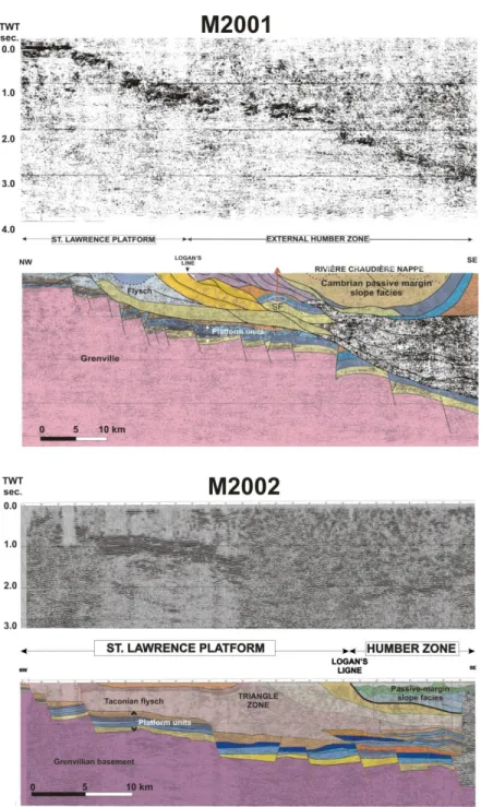
Figure 4 and Figure 5). The Humber zone is bordered to the west by the St. Lawrence Platform (Sanford, 1993); the limit is the westernmost transported tectonic slices (Globensky, 1987; Waldron et al., 1998). This limit in southern Québec is commonly referred to as the Logan’s line,
or as the Champlain Thrust in northern Vermont. Seismic data however, indicate that the St. Lawrence Platform records significant Taconian (?) compressive deformation (
Figure 4), which include triangle zone and blind thrusts found in the central segment of the St. Lawrence Platform in southern Québec (Castonguay et al., 2003, 2006; 2010). Therefore in Québec, the Appalachian structural front does not coincide with Logan’s line. To the east, the Humber Zone is bordered by the Dunnage Zone, which consists of various oceanic rocks; the western limit of the Humber Zone consists of faults that form the Baie Verte – Brompton Line (Figure 2; Tremblay et al., 1995; van Staal, 2005). Differences in the degree of deformation and metamorphism led St-Julien and Hubert (1975) to divide the Taconian deformed Laurentia continental rocks of the Québec Reentrant into two domains (Figure 2): a western external domain with low deformation and low-grade metamorphism that passes eastward to an internal domain with higher-grade metamorphic rocks as well as polyphase tectonic deformation (Pinet et
Figure 4 - Seismic lines M2001 and M2002 in southern Quebec imaging the St Lawrence Platform, the Appalachian structural front and the stack of nappes in the Humber domain. Only the northwestern segment of line M2001 is shown. Note the development of significant compressive structures west of the Logan’s line, in particular, a shallow triangle zone on M2002. The position of the Saint-Flavien gas field is shown on the M2001 line. The deformation is thin-skinned. Modified from Castonguay et al. (2010). Location of the lines in southern Quebec is shown by the red lines on Figure 1.
Figure 5. Seismic line 91-20 offshore western Newfoundland imaging the platform and foreland-basin successions involved in thick-skinned deformation with basin inversion along the Round Head Thrust Fault (RHT) and the development of a triangle zone. The projected position of the onshore Garden Hill (GH) oil field is shown. Modified from Stockmal et al. (1998). RIT: Red Island Thrust; SGT: St. George Thrust; TCT: Tea Cove Thrust. Location of the line is shown by the blue line on Figure 1.
The relative timing of obduction of the oceanic seafloor units onto the continental margin in the Québec Reentrant has been traditionally indirectly determined by the biostratigraphic age of the successions that under- and overlie the accreted units of the Dunnage Zone (St-Julien and Hubert, 1975). Recent 40Ar/39AR and K/Ar metamorphic ages confirm the “classic” Middle to Late Ordovician Taconian age (Castonguay et al., 1997; Pincivy et al., 2003; Glasmacher et al., 2003; Malo et al., 2008) for the ophiolite obduction onto the continental slope margin successions. At the St. Lawrence Promontory in western Newfoundland, the obduction of the Bay of Island ophiolite and the associated Humber Arm Allochthon onto the continental margin of Laurentia was long considered to be Middle Ordovician in age (Williams, 1975). This “classic” Taconian age is supported by the biostratigraphic ages of the Taconian flysch and of the overlying units. However, detailed geochronology, structural studies and industry seismic data (Figure 5) indicate that the emplacement of oceanic-domain units over the shallow segment of the continental margin started in Silurian (Dunning et al., 1990; Cawood et al., 1994) and ended prior to the Viséan (Carboniferous), likely in Middle Devonian (Cawood, 1993; Waldron
et al., 1998; Stockmal et al., 1998; 2003; 2004). The “Taconian” event near the St. Lawrence
Promontory resulted from the emplacement of the oceanic seafloor and composite terranes on distal deep marine continental slope succession (van Staal et al., 1998; Waldron and van Staal, 2001). It has been proposed that subduction near the continental margin of Laurentia started in
the lastest Cambrian with the obdcution of the Lushs Bight Oceanic Tract (Swinden et al., 1997) over the Dashwoods microcontinent (Waldron and van Staal, 2001), the latter being lately detached from Laurentia (Waldron and van Staal, 2001). The accretion of the new composite terrane along the continental margin at the St. Lawrence Promontory marks the onset of the Taconian orogeny there (van Staal, 2005).
4.1. End rift–early drift
In western Newfoundland, the oldest rift-related event is dated at 615 Ma (Kamo et al., 1989), however, Cawood et al. (2001) documented that significant rifting only started at 570 Ma with a last pulse at 555-550 Ma (van Staal et al., 1998; Waldron and van Staal, 2001; van Staal, 2005). For the western Newfoundland platform succession, James et al. (1989) identified the end rift – early drift episode as the “pre-platform shelf” which is recorded by the Lower Cambrian Labrador Group. This event coincides with the Sauk I sub-sequence of the Early Cambrian (Sloss, 1963).
In Québec, dike-swarm tholeiites in the Grenvillian province give a 590 Ma age (Kamo et
al., 1995). Rift-related alkaline basalts and comendites of the Tibbit Hill Formation in southern
Québec gave 554 Ma (Kumarapeli et al., 1989). Similar rift basalts are found in the Caldwell and Shickshock groups and the Montagne Saint-Anselme Formation in southern Québec, Gaspé Peninsula and eastern Québec, respectively. U-Pb dating of the volcanic rocks at the Montagne Saint-Anselme yields an age of 561 ± 7 Ma, whereas basalts of the Shickshock Group at the Lac Matapédia (Gaspé Peninsula) yield ages of 565 ± 6 Ma and 556 ± 5 Ma (Cox et al., 2005). A felsic phase within the Caldwell lavas gave a radiometric age of 562 ± 2 Ma (J. Bédard, pers. comm., 2003). There is no unequivocal preserved record of Early Cambrian facies on the St. Lawrence Platform. The Potsdam Group unconformably overlies Precambrian basement; the lower formation (Covey Hill Formation) is assigned an Early Cambrian age (Sanford, 1993) without supporting faunal elements although more recently Late Cambrian medusa have been reported from the top of the Covey Hill Formation (Lacelle et al., 2008). At the eastern end of the Humber Zone (Figure 2), tectonic stacks of the shallow-marine Oak Hill Group (Charbonneau, 1980) overlie rift volcanics (Kumarapeli et al., 1989; Castonguay et al., 2001). The Cheshire (sandstone) and Dunham (carbonate) formations have yielded Early Cambrian faunal elements (Clark, 1936: Clark and McGerrigle, 1944).
4.1.1. The St. Lawrence Promontory (western Newfoundland)
The Lower Paleozoic continental margin of Laurentia preserved in western Newfoundland was built on the St. Lawrence Promontory (Figure 3) (Thomas, 1977, 1991; Miall and Blakey, 2008; Allen et al., 2009, 2010). Autochthonous and transported rocks are preserved. The best known of the allochthons is the Humber Arm Allochthon (Williams, 1975). Its sedimentary rock package forms the Humber Arm Supergroup (Stevens, 1970).
Figure 6. a) End-rift (green-coloured) and passive margin (blue-coloured) stratigraphic correlation of platform succession and Humber Zone continental-slope sediments in Western Newfoundland. The Humber Arm Supergroup consists of the lower Curling Group and the laterally equivalent Cow Head and Northern Head groups. Designation of units as follows: GROUP, Formation, Member. Foreland-basin units are in italic. Step: Steptoan, Sunw: Sunwaptan, Skull: Skullrockian, Trem: Tremadocian, Darr: Darriwilian. b) General lateral relationship of stratigraphic units from platform to distal slope. BMDB: Blow Me Down Brook Formation, Summer: Summerside Formation. Red-coloured intervals represent a hiatus. Not to scale. Modified from James et al. (1989) and Lavoie et al. (2003b).
The current framework includes a Neoproterozoic (?) - Lower Cambrian Curling Group (Summerside, Irishtown, and Blow Me Down Brook formations), a Middle Cambrian - mid Arenigian Northern Head Group (Cooks Brook and Middle Arm Point formations) and the coeval, laterally correlative Cow Head Group (Shallow Bay and Green Point formations) (Figure 6). The lower assemblage (the Curling Group) has no equivalent below the Cow Head Group
(Figure 6). The slope and rise sediments of the end-rift episode are recorded in the Curling Group (Lavoie et al., 2003b).
The Neoproterozoic to Lower Cambrian Summerside Formation consists of slates with subordinate meta-sandstones and conglomerates (Stevens, 1965, 1970; Waldron and Palmer, 2000; Palmer et al., 2001; Waldron et al., 2003). The overlying Lower Cambrian Irishtown Formation consists of slates with sandstones and limestone conglomerates (Palmer et al., 2001). The upper Lower Cambrian Blow Me Down Brook Formation (Botsford, 1988; Lindholm and Casey, 1990; Burden et al., 2001) consists of parallel and cross-laminated, quartz-rich feldspathic sandstone with shale (Waldron and Palmer, 2000; Buchanan et al., 2001; Waldron et
al., 2001, 2003).
The Curling Group is time-correlative with the Lower Cambrian shallow marine Labrador Group (James et al., 1989; Figure 6). Microfaunal correlations have been proposed between the Curling Group and the Forteau Formation (Labrador Group) (Burden et al., 2001; Normore, 2001). The upper unit of the Labrador Group, the Hawke Bay Formation, records a major sea-level lowstand (James et al., 1989). It has been proposed that massive sandstone and conglomerate in the upper part of the Irishtown Formation represents the slope record of that major lowstand (James et al., 1989; Palmer et al., 2001; Lavoie et al., 2003b).
4.1.2. The Québec Reentrant (Eastern Québec)
In eastern Québec, the Lower Paleozoic continental margin of Laurentia was built in the Québec Reentrant (Figure 3) (Thomas, 1977, 1991; Miall and Blakey, 2008; Allen et al., 2009, 2010). The Humber succession in the Québec Reentrant occurs in a number of stacked structural nappes (Figure 2), for which stratigraphic nomenclatures were only recently synthesized (Lavoie
et al., 2003b) (Figure 2 and Figure 7).
At the base of the Humber succession, the undated Saint-Roch Group (and correlative units; Figure 7) consists of mudstone with subordinate sandstone and rift volcanics (Lavoie, 1997). A distinctive unit of massive, pebbly green sandstone with red and green mudstone of late Early Cambrian age (Saint-Nicolas – “green sandstone” and correlative units; Figure 7) overlies the basal succession (Sweet and Narbonne, 1993; Lavoie et al., 2003b; Burden, 2003). This distinctive massive sandstone unit is a regional marker. It has been proposed that this coarse-grained unit represents the deep-marine expression of a significant late Early Cambrian sea-level lowstand (Lavoie et al., 2003b).
Figure 7. End-rift (green-coloured) and passive-margin (blue-coloured) stratigraphic correlations of platform and Humber Zone continental-slope sediments in the Québec Reentrant in (a) southern Québec and (b) eastern Québec - Gaspé. See Figure 6 for unit status. Autoch: Autochthonous units of the St. Lawrence Platform. Alloch: Allochthonous platform thrusts in the Humber Zone. BEEKMAN: Beekmantown Group, Hasting Cr: Hasting Creek Formation, Naylor Led: Naylor Ledge Formation, Kam: Kamouraska Formation, L.C.: Lévis Formation conglomerate. Red-coloured intervals are for hiatus. c) Schematic composite diagram of the St. Lawrence Platform and Humber Zone illustrating the assumed palinspastically restored lateral relationships
of some tectonostratigraphic nappes. Note the thickening of the sedimentary pile toward the east. The Early Cambrian platform units of the Oak Hill Group are part of a distinct tectonic nappe. Vertical exaggeration 15x. Modified from Lebel and Kirkwood (1998).
4.1.3 Correlation western Newfoundland – Québec
Following the late Neoproterozoic initiation of spreading and eruption of basalts with associated coarse-grained sedimentation (Wood Island Lavas, Bradore, Saint-Anselme and Tibbit Hill formations, Caldwell and Shickshock groups), the ensuing relative sea-level rise led to shallow-marine carbonate-siliciclastic sedimentation on local horst structures (Forteau and Dunham formations), whereas in the graben and slope settings, fine- and coarse-grained sediments were deposited as proximal and distal submarine fans (Summerside, Irishtown, Blow Me Down Brook, Sainte-Foy and Armagh formations, lower beds of Saint-Roch Group) (Figure 8 and Figure 9a). A major sea-level lowstand is recognized in late Early Cambrian and marks the end of the Sauk I sub-sequence (James et al., 1989; Lavoie et al., 2003b). This lowstand is recorded in prograding shallow-marine sandstone such as the Hawke Bay (Newfoundland; Knight and Boyce, 1987) and Monkton (Vermont; Landing et al., 2002) formations. This event is expressed in the deep-marine sandstone and conglomerate found in the upper part of the Irishtown, in the Blow Me Down Brook and Saint-Nicolas formations and the “green sandstone” unit of the Saint-Roch Group (Figure 8 and Figure 9b).
Figure 8. Stratigraphic correlation of the end-rift (Sauk I sub-sequence; green-coloured) and passive-margin (Sauk II and III; blue-coloured) successions in the Québec Reentrant and at the St. Lawrence Promontory.
Correlations for platform and slope rock units are proposed; see text for details. Red-coloured intervals are for hiatus. See Figure 6 and Figure 7 for unit status and acronyms. Modified from Lavoie et al. (2003b).
Figure 9. a) Interpreted paleogeographic reconstruction of the Laurentian continental margin in Early Cambrian. Geographically restricted carbonate platforms (Forteau / Dunham) are located on rift-related horsts, while intervening deep grabens are filled by coarse- to fine-grained slope sediments (Armagh / Saint-Roch / Summerside). The thick dashed line represents the assumed position of the continental shelf edge. b) Paleogeographic reconstruction in late Early Cambrian at the time of the “Hawke Bay event” (first major sea level lowstand) that marks the end-rift episode. Shallow-marine quartzite (Monkton / Hawke Bay) prograded towards the shelf break while deeper slope environments were fed by coarse-grained sediments (“Green Sandstone” / Irishtown) from the prograding clastic wedge. Modified from Lavoie et al. (2003b). The cartoon illustrates the late Early Cambrian paleoenvironmental model; the progradation of the clastic wedge (Hawke Bay Formation) responds to the major sea-level lowstand. Cartoon modified from James et al. (1989).
4.2. The passive margin
In western Newfoundland, the late Early Cambrian shallow-marine clastics were flooded by the transgressive sea level that marks the initiation of the Sauk II sub-sequence (James et al., 1989). The carbonate-dominated passive-margin consisted in a Middle-Late Cambrian narrow, high-energy carbonate platform (Port au Port Group) that evolved into an Early-earliest Middle Ordovician wide, low-energy carbonate platform (St. George Group) (Figure 6; James et al.,
1989). The passive-margin period ended with onset of significant sea-floor subduction, and the migration of a tectonic peripheral bulge on the margin in earliest Middle Ordovician (Jacobi, 1981; Knight et al., 1991; Lavoie et al., 2012). This event coincides with the end of the Sauk sequence, the beginning of the Tippecanoe sequence and the inception of the Taconian foreland basin (Figure 1, Figure 2 and Figure 3).
In the Québec Reentrant (Figure 7), the oldest known passive-margin, shallow-marine platforms are the upper Middle Cambrian Corner-of-the-Beach Formation (Kindle, 1942; Lavoie, 2001) and the shallow-marine carbonate platform of the Upper Cambrian Strites Pond Formation (Salad Hersi and Lavoie, 2001a; Salad Hersi et al., 2002b). These two formations are facies-wise similar to the Port au Port Group (Lavoie, 2001; Salad Hersi and Lavoie, 2001a; Salad Hersi et
al., 2002b; Lavoie et al., 2012). The shallow-marine record of the Sauk II and III sub-sequences
is best expressed in the extensive Lower Ordovician carbonates of the Beekmantown and Philipsburg groups of southern Québec (Globensky, 1987; Bernstein, 1992; Salad Hersi et al., 2002a, 2002b, 2003; Salad Hersi, 2012; Dix, 2012) as well as of the Romaine Formation on Mingan Islands (Desrochers, 1988; Desrochers et al., 2012). The Lower Ordovician units are truncated by the unconformity resulting from the migration of the peripheral bulge (Knight et al., 1991; Lavoie, 1994).
4.2.1. The St. Lawrence Promontory (western Newfoundland)
The slope record of the passive margin consists of two laterally correlative rock packages: 1) the Middle Cambrian-lowermost Middle Ordovician proximal Cow Head Group and 2) the coeval, but more distal, succession of the Northern Head Group (Figure 6). These deep-marine successions are well-dated; limestone fragments in the conglomerates that punctuate the succession are rich in shallow-marine fauna, whereas the intervening fine-grained sediments are dated by graptolites and acritarchs.
The Cow Head Group has been extensively studied (James and Stevens, 1986; Coniglio, 1986; James et al., 1989) and consists of two laterally correlative formations, the proximal Shallow Bay and the distal Green Point formations (Figure 6). Seven distinctive rock assemblages (defined as members) of alternating shales, sandstones and fine to coarse-grained limestones are recognized in the Shallow Bay (four members) and Green Point (three members) formations (Figure 6). The biostratigraphy allows correlation between both formations, with the shallow-marine platform and with the Cambrian Grand Cycles framework (James and Stevens, 1986; James et al., 1989).
The Northern Head Group (Botsford, 1988) consists of the Cooks Brook and Middle Arm Point formations (Figure 6). The limestone and shale succession of the upper Middle Cambrian to Lower Ordovician Cooks Brook Formation disconformably overlies the upper Lower Cambrian Irishtown Formation (Figure 6). The Middle Arm Point Formation consists of mudstone with subordinate silty dolostone and limestone that carry Tremadocian to Arenigian age graptolite.
The passive-margin succession in western Newfoundland consists of proximal (Cow Head Group) and distal (Northern Head Group) depositional assemblages (Figure 6). The detailed
work by James and Stevens (1986) and James et al. (1989) correlates the evolution of the Cow Head Group with that of the coeval shallow-marine Port au Port and St. George groups (Figure 6). Two major T-R cycles (Sauk II and III sub-sequences) are recorded in the Cow Head Group. Correlation of the Cow Head Group with the Northern Head Group is also proposed (Figure 6) (Lavoie et al., 2003b).
4.2.2. The Québec Reentrant (Eastern Québec)
The first passive-margin sediments that overlie the upper Lower Cambrian green sandstone unit consist of a thick succession of upper Lower Cambrian to lower Middle Cambrian mudstone with glauconite- and quartz-rich sandstone (Orignal Formation and correlative units; Figure 7). A distinctive coarse-grained unit (Saint-Damase Formation and correlative units; Figure 7) overlies this fine-grained dominated interval. This unit consists of channel-fill carbonate conglomerate, feldspathic and siliceous sandstone and minor mudstone (Lavoie, 1998). The matrix of the conglomerate is Late Cambrian and embedded fragments consist of Early to early Late Cambrian nearshore to shallow marine platform margin limestone facies together with meter-sized sandstone, basalt fragments and basement-derived gneiss and orthoquartzite (Lavoie, 1997, 1998).
The coarse-grained interval is overlain by a succession of uppermost Cambrian to lowermost Ordovician mudstone with subordinate sandstone (Rivière-du-Loup Formation and correlative units; Figure 7) with discontinuous thick channel-fill quartz arenite (Kamouraska Formation; Figure 7).
The youngest passive margin unit (Rivière-Ouelle Formation and correlative units; Figure 7) consists of variegated mudstone with subordinate sandstone, ribbon limestone, calcarenite and limestone conglomerate of Early Ordovician age (Landing and Benus, 1985; Landing et al., 1986; Bernstein et al., 1992; Maletz, 1992, 2001; Asselin and Achab, 2004).
4.2.3. Correlation Newfoundland – Québec
The passive-margin history consists of two major T-R cycles identified as the Sauk II and III sub-sequences (Figure 8). The initial Sauk II transgressive and early highstand sea-level (Middle Cambrian) resulted in the sedimentation of the lower part of the Port au Port Group with no preserved slope record until the late Middle Cambrian (Cooks Brook Formation). In eastern Québec, the Corner-of-the-Beach Formation indicates that the Middle Cambrian platform locally extended into the more outer part of the Québec Reentrant; the slope record consists only of mudstone and sandstone (e.g., Orignal Formation and equivalent units). A sea-level lowstand is recognized near the base of the Late Cambrian (Steptoan) and correlates with the end of Grand Cycle A (Chow and James, 1987; Cowan and James, 1993), whereas the slope record of the marine lowstand is found in limestone conglomerates at the base of the Shallow Bay and Cooks Brook formations. These conglomerates consist of limestone fragments derived from late highstand to lowstand shedding of platform-margin facies (James et al., 1989). In Québec, no record of lower Upper Cambrian platform rocks is known, but the widespread lower Upper Cambrian (Steptoan) slope limestone conglomerates (Saint-Damase Formation and correlative
units) indicate the former presence of this platform. These thick conglomerates correlate with the end of the Sauk II sub-sequence.
Presence of the pre-Upper Cambrian fragments in the conglomerate makes the Upper Cambrian conglomerates of the Québec Reentrant different from the Newfoundland time-correlatives. Simple late-highstand to lowstand shedding of platform-margin clasts cannot alone explain the presence of fragments of Neoproterozoic (basement) to Late Cambrian age. The thickest and best developed conglomerate successions are found in eastern Quebec, adjacent to the Saguenay Graben (Aulacogene of Kumarapeli and Saull, 1966; Figure 2 and Figure 10a) and a Late Cambrian reactivation of this failed Neoproterozoic rift has been proposed as causal mechanism (Lavoie et al., 2003b). This erosion of the continental margin ended with the final exhumation of basement rocks through erosion of the carbonate, clastic and volcanic succession deposited during and after the rift episode. The exact cause for the reactivation of the Saguenay Graben is still unclear; however, the first accretionary events recorded in circum-Iapetus terranes occurred in late Middle Cambrian (Miall and Blakey, 2008). This is well-documented by the Penobscotian Phase in the units of the peri-Gondwana Gander terrane (Neuman, 1967) and in the obduction of the peri-Laurentia Bushs Bight Oceanic Tract over the Dashwoods microcontinent (van Staal et al., 2004). The latter accretion occurred in the neighbourhood of Laurentia and could have been the trigger for late Cambrian tectonic instability in the Quebec Reentrant.
At the onset of the Sauk III sub-sequence (Figure 8), a sea-level highstand is recorded in the Grand Cycle C and is dated as late Steptoan. On the Newfoundland platform, this marine highstand is recorded in the Berry Head Formation (Port au Port Group); in the slope environment, the finer-grained units of the Cow Head Formation record this high sea level. No carbonate platform of that age is known in the Québec Reentrant, but a fine-grained siliciclastic slope record (Rivière-du-Loup Formation and equivalents units) likely correlates with the Newfoundland slope succession. This highstand was followed by another sea-level lowstand in latest Cambrian (early Skullrockian), which marks the end of the Port au Port Group in western Newfoundland. In the slope environment, the fine-grained succession of the Cow Head Group passes into a more conglomeratic section. In southern Québec, the platform carbonates of the Strites Pond Formation are dated as latest Cambrian (Skullrockian), and it is capped by an erosive subaerial unconformity, which separates it from the outer-shelf facies of the upper Tremadocian Wallace Creek Formation (Salad Hersi and Lavoie, 2001a; Salad Hersi et al., 2002b; Lavoie et al., 2012). The coeval slope record of this erosive event is the thick channel-fill quartz sands of the Kamouraska Formation.
Figure 10. a) Interpreted paleogeographic reconstruction of the Laurentian continental margin in Late Cambrian (Skullrockian). Lateral relationship between the Cairnside and Strites Pond formations is discussed in Salad Hersi et al. (2002a, 2002b). The thickest succession of the Upper Cambrian conglomerates (Saint-Damase and correlative units) with older basement and platform rocks are found in the Lower St. Lawrence Valley, near the Saguenay Graben (SA). The two cartoons illustrate the depositional settings and lateral platform – slope relationships in Middle-Late Cambrian. Not to scale. b) Interpreted paleogeographic reconstruction of the Laurentian continental margin in Early Ordovician (Arenigian). The lateral relationship between the Theresa and Wallace Creek formations is discussed in Salad Hersi et al. (2002b, 2003). Thick white dashed lines represent the hypothetical facies transition from proximal to distal slope facies. The diachronism in Early Ordovician sea level lowstands (Tremadocian-Arenigian in Western Newfoundland and mid-Arenigian in southern Québec) is interpreted to have been related to the tectonic influence of the Ottawa – Bonnechère Graben (O-B). The two cartoons illustrate the depositional settings and lateral platform – slope relationships in Early Ordovician. Not to scale.
The Early Ordovician was marked by craton-wide transgression leading to the deposition of the St. George Group in western Newfoundland (Pratt and James, 1986), the Romaine Formation on Mingan and Anticosti islands (Desrochers, 1988; Brennan-Alpert, 2001: Desrochers et al., 2012) and the Beekmantown Group in southern Québec and eastern Ontario
(Bernstein, 1992; Salad Hersi et al., 2002a, 2003; Salad hersi, 2012; Dix 2012) (Figure 8). Two T-R depositional cycles are recognized; the mid Boat Harbour Formation unconformity (Tremadocian-Arenigian boundary) separates these two cycles (James et al., 1989) as does the slightly younger (mid-Arenigian) Theresa – Beauharnois formation contact (Salad Hersi et al., 2003; Dix and Salad Hersi, 2004; Dix and Al Rodhan, 2006). In western Newfoundland, the first cycle covers the Tremadocian; the second cycle is Arenigian to Darriwilian in age. In southern Quebec and eastern Ontario, the T-R cycles are seemingly younger; the first cycle is upper Tremadocian to mid-Arenigian whereas the second one is mid-Arenigian to Darriwilian in age (Dix and Salad Hersi, 2004). Tectonic instability associated with the Ottawa – Bonnechère Graben has been proposed to explain the diachronism in the sea level fluctuations, conversely imprecise biostratigraphic data could also be envisaged (Dix and Salad Hersi, 2004; Dix and Al Rodhan, 2006). In the coeval slope succession, these limits of the T-R cycles are expressed in shedding of major limestone conglomerates in the Shallow Bay (James et al., 1989) or in the Lévis (Samson et al., 2002; Lavoie and Kirkwood, 2006) formations (Figure 8).
4.3. A regional sea-level scenario for the Lower Paleozoic end-rift and passive margin
The proposed Newfoundland-Quebec correlation allows the recognition of four distinctive major sea-level lowstands (Figure 11):
1) A late Early Cambrian event (“Hawke Bay event”) expressed by massive sandstones and conglomerates. This event marks the upper limit of the Sauk I subsequence. 2) An early-mid Upper Cambrian event (Steptoan-Sunwaptan) expressed in limestone
conglomerates on the slope. Coeval tectonic instability is indirectly documented near the Saguenay Graben in the Québec Reentrant. This event marks the end of the Sauk II subsequence.
3) A latest Cambrian event (early Skullrockian) represented by local limestone conglomerates and coarse-grained clastics. This event occurs within the Sauk III subsequence but marks the end of the Cambrian Grand Cycle C.
4) a) In western Newfoundland, a sea-level lowstand at the Tremadocian – Arenigian boundary represented by more limestone conglomerates, and b) in southern Québec – eastern Ontario, a slightly younger sea-level lowstand in mid-Arenigian expressed in the major limestone conglomerate of the Lévis Formation. Diachronism is related to tectonic instability of the Ottawa – Bonnechère Graben (Dix and Salad Hersi, 2004).
Figure 11. Chronostratigraphic correlation for selected units of the end-rift – passive-margin successions along the entire Canadian segment of Laurentia. The four major sea-level lowstands discussed in text (blue-coloured intervals) are identified (1 to 3 and the slightly diachronous 4a and 4b). Depositional hiatus are in red. The sea-level curve is from James et al. (1989); the curve applies well to the Québec succession prior to the Early Ordovician. The dashed line displays the Quebec Reentrant departure from the James et al. (1989) curve. Correlation with Cambrian Grand Cycles is shown. MH PT : March Point Fm.; Berry HD: Berry Head Fm.; Agua: Aguathuna Fm.; Summ: Summerside Fm.; Irish: Irishtown Fm.; Covey H: Covey Hill Fm; Strites P: Strites Pond Fm.; Wal Cr: Wallace Creek Fm.; MC: Morgan’s Corner Fm.; Hast Cr: Hasting Creek Fm.; NL: Naylor Ledge Fm.; St.Dama: Saint-Damase Fm.; RDL: Rivière-du-Loup Fm.; Kamour: Kamouraska Fm.; L.C.: Lévis Formation. Modified from Lavoie et al. (2003b).
The stratigraphic record indicates that tectonism was sporadically active in the Quebec Reentrant from Late Cambrian to Early Ordovician (Lavoie et al., 2001a; Lavoie et al., 2003b; Dix and Salad Hersi, 2004; Dix and Al Rodhan, 2006). Evidence for such instability is associated with the two failed aulacogens in the Quebec Reentrant, the Ottawa – Bonnechère and the Saguenay grabens.
4.4. The Taconian foreland basin
The building of passive-margin successions along the eastern seaboard of Laurentia was stopped by emergence and sub-aerial exposure of the platform in earliest Middle Ordovician. The resulting break is known variously as the St. George (Newfoundland; Knight et al., 1991), the Romaine (Anticosti; Desrochers, 1988), the Beekmantown (southern Québec; Dykstra and Longman, 1995; Salad Hersi et al., 2003), the intra-Philipsburg (southern Québec – Vermont; Knight et al., 1991; Salad Hersi et al., 2007), or the Knox (east U.S.A.; Read, 1989; Ettensohn, 2008) unconformity. This unconformity coincides with the boundary between Sloss’ (1963) Sauk and Tippecanoe Sequences and marks the inception of the foreland basin at Laurentian continental margin (Figure 1 and Figure 3). The evolution of the foreland basin became strongly diachronous along strike of the continental margin, which suggests that the reentrant-promontory morphology played a key role in the evolution of Laurentia (Lavoie, 1994; Ettensohn, 2008).
4.4.1. The St. Lawrence Promontory (Western Newfoundland)
At the St. Lawrence Promontory (Figure 3), the migration of a tectonic peripheral bulge led to compression, block faulting, uplift and erosion of the St. George carbonate platform. The following subsidence contributed to Mid-Darriwilian carbonate sedimentation (Table Point Formation; Stenzel et al., 1990) (Figure 12). Continued subsidence led to deep-marine carbonate-shale and eventually to deep-marine shales. Early tectonic exhumation along the Round Head Precursor Fault (Waldron et al., 1993; Stockmal et al., 1998) resulted in local submarine erosion of tectonic escarpments and sedimentation of fault-scarp conglomerates (Cap Cormorant Formation). In late Darriwilian, the Taconian-derived foreland flysch (Mainland Sandstone of the Goose Tickle Group; Quinn, 1995) was deposited on the foundered platform (Figure 12).
The transition from the passive margin to a foreland basin is well expressed in the slope and rise environment (Figure 12). Greenish flyschoid sandstone with subordinate shale of the middle to upper Darriwilian Lower Head Formation (James and Stevens, 1986) conformably overlies the proximal carbonate-rich succession of the Cow Head Group. Flyschoid sandstone with shale of the Arenigian to Darriwilian Eagle Island Formation (Waldron et al., 1998; Waldron and Palmer, 2000) overlies the Middle Arm Point Formation of the Northern Head Group. Taconian flysch are demonstrably slightly older in the more distal successions (Figure 12).
Figure 12. Middle to Late Ordovician foreland-shelf to slope stratigraphic framework at the St. Lawrence Promontory and in the Quebec Reentrant. In Newfoundland, the shallow-marine units are restricted to the Darriwilian and the shelf was buried by westerly migrating Taconian flysch (green-coloured) by late Darriwilian. CC: Cap Cormorant Formation; TC: Table Cove Formation; BC: Black Cove Formation. In the Quebec Reentrant, a progressive westward foundering (green-coloured flysch units) of shallow-marine settings occurred in Late Ordovician (Caradocian – Ashgillian). Taconian flysch sedimentation on the slope was initiated in late Arenigian (Newfoundland) to early Darriwilian time. Red-coloured intervals are for depositional hiatus. The sea-level curve of Ross and Ross (1988) indicates that the evolution of the
Newfoundland succession was controlled primarily by tectonism. The Québec Reentrant successions locally record eustatic events (lowstand in yellow, highstands in blue). F: relative sea-level fall; R: relative sea-level rise.
4.4.2. The Québec Reentrant (Eastern Québec)
The inception of the foreland basin and increased tectonic subsidence in the Québec Reentrant (Figure 3) was marked by a significant change in the St. Lawrence platform (Sanford, 1993). Siliciclastic units covered the unconformity (Globensky, 1987; Desrochers, 1988; Salad Hersi and Dix, 1997), and were followed by a thick succession of ramp carbonates in a tectonically active environment (Desrochers, 1988; Sanford, 1993; Lavoie, 1994, 1995a; Sharma
et al., 2003; Lemieux et al., 2003). The carbonate sedimentation was shut down diachronously in
and final molasse (Sanford, 1993; Lavoie, 1994; Sharma et al., 2003) (Figure 12). A similar westward “younging” of flysch sedimentation is also noted for coeval successions in eastern US (Ettensohn, 2008). In the Québec Reentrant, the carbonate sedimentation lasted from Darriwilian to late Caradocian.
The passive-margin slope deposits are overlain by Darriwilian to lowermost Caradocian flyschoid sandstone with subordinate mudstone, calcarenite, conglomerate and chert (Tourelle Formation and equivalent units, Figure 12) (Clark and Globensky, 1973; Biron, 1974; Hiscott, 1978; De Broucker, 1986; Slivitzky and St-Julien, 1987; Slivitzky et al., 1991; Bloechl, 1996; Prave et al., 2000).
Peculiar mélanges are widely distributed and are interpreted to be roughly coeval with these Middle Ordovician units (Figure 12). The best exposed of these mélanges is the Cap Chat Mélange (Cousineau, 1998). This mélange consists of broken units of the adjacent formations, in particular, cm- to km-sized blocks of the Rivière Ouelle, Tourelle and Des Landes formations (Arenigian to Darriwilian) in a muddy to sandy matrix. In southern Québec (Figure 12), chaotic units described as polymictic conglomerate (Citadelle Formation; Osborne, 1956), olistostrome (Drummondville Olistostrome; Slivitzky and St-Julien, 1987) and tectonosome (Pointe-Aubin mélange; Comeau et al., 2004) are exposed. These chaotic units in southern Québec differ from the Cap Chat Mélange; they are composed of small to large-sized blocks of the various lithologies found in the shallow- and deep-marine passive-margin and foreland-basin succession.
Syn-orogenic sedimentation lasted until end-Caradocian in the Gaspé Peninsula and is represented by Upper Ordovician coarse and fine-grained flysch (Cloridorme Formation; Enos, 1969; Prave et al., 2000) (Figure 12). The Cloridorme Formation is coeval with flysch on the St. Lawrence Platform (Globensky, 1987) (Figure 12).
4.4.3. Correlation Newfoundland – Québec
The evolution of the end-rift and passive-margin episodes was primarily controlled by eustacy with tectonism locally recognized in the proximity of failed rift grabens (Ottawa – Bonnechère and Saguenay grabens). Differences are recorded at the onset of closure of the Humber Seaway (Waldron and van Staal, 2001), a sea arm of the Iapetus Ocean that separated the Dashwoods microcontinent from Laurentia. These differences are expressed in the timing of various sedimentary events (Figure 12). This diachronous evolution suggests that the overriding control on development and evolution of depositional successions was tectonic (see also Ettensohn, 2008). The Middle to Late Ordovician eustatic sea-level curve of Ross and Ross (1988) suggests three transgressive – regressive (T-R) events in that period (Darriwilian to end-Ashgillian) corresponding to Sloss’s (1963) Tippecanoe I Sub-sequence (Figure 12). These T-R cycles are: 1) Darriwilian, 2) Caradocian and 3) Ashgillian (Figure 12). Glacio-eustatic processes controlled the last one of these cycles (Brenchley et al., 1994; Gibbs et al., 1997; Lavoie and Asselin, 1998).
The foundering of the continental margin at the St. Lawrence Promontory occurred in the middle to late Darriwilian (Stenzel et al., 1990; Quinn, 1995) at a time of eustatic sea-level fall during the first T-R cycle (Figure 12); this suggests an overriding tectonic control on facies
architecture and evolution. The coeval record in the Québec Reentrant suggests the presence of an overall transgressive-regressive cycle, which starts at the Sauk-Tippecanoe unconformity and ends in an unconformity that separates the Chazy and Black River groups (Salad Hersi and Lavoie, 2001b; Dix, 2003) (Figure 12). This suggests that the Darriwilian succession in the Québec-Ontario shallow-foreland recorded a eustatic signal. The Caradocian and Ashgillian T-R eustatic cycles are imperfectly recorded; the transition from carbonate ramp (Trenton Group) to deep-marine sediments (Utica) and flysch (Sainte-Rosalie) records tectonically driven deeper marine conditions (Lavoie, 1994; Lavoie and Asselin, 1998) (Figure 12).
Detailed sedimentologic analyses are unavailable for the deeper marine successions preserved in the Taconian allochthons. The lateral variation in time and nature of Middle-Upper Ordovician Mélanges in the Québec Reentrant and St. Lawrence Promontory reflects foreland-propagating compression and local exhumation and erosion of different segments of the foreland and older passive-margin facies. The propagation of compressive deformation and stacking can form depositional basins fed by the exposed succession at the top of the structural stack (Stockmal et al., 2003). The mid-Darriwilian Cape Cormorant in western Newfoundland represents one of these proximal tectonic basins (Stenzel et al., 1990; Waldron et al., 1993). In the Quebec Reentrant, the Darriwilian Cap Chat Mélange formed far away from the shelf break as it only consists of cannibalized coeval to slightly older deep-marine units. The Darriwilian chaotic units in southern Québec formed closer to the shelf break as suggested by the nature of the fragments (Comeau et al., 2004). These basins reached the shelf in Caradocian resulting in the Lacolle Breccia, for which event and facies correlations with the Darriwilian Cape Cormorant Conglomerate has been proposed (Lavoie, 1994).
5. THE POST-TACONIAN TO ACADIAN BASINS
In eastern North America, the timing and physical expression of the Taconian Orogeny varies significantly (Lavoie, 2008; Ettensohn, 2008). Along strike in the Appalachians, significant stratigraphic differences are known in the Upper Ordovician to Middle Devonian successions, which led previous workers to propose distinct sedimentary basins. These basins may overlie more than one of the previous Taconian zones and they are spatially distinguished and defined on lithologic, paleontological and structural elements.
These basins overlie Taconian zones either unconformably or paraconformably. The most pronounced unconformities occur where the middle Paleozoic successions overlie the Humber Zone. In most cases, where middle Paleozoic strata overlie the Dunnage Zone, the contact is a paraconformity with a more or less important time hiatus.
Figure 13. Stratigraphic relationships between the Taconian foreland-shelf and flysch and the overlying post-Taconian basins. Note that the time hiatus (red-coloured intervals) increases from Newfoundland to northern Gaspé. The post-Taconian flysch succession of the Clam Bank Belt in western Newfoundland is detailed. The base of the Long Point Group (Lourdes, Winterhouse and Misty Point formations) is older than the end of Taconian foreland-shelf and flysch in the Québec Reentrant. The Ross and Ross (1988) sea-level curve for the Late Ordovician indicates a Caradocian T-R cycle correlative with the one recorded by the Long Point Group. The Lower Devonian Clam Bank Formation unconformably overlies the Long Point Group with no preserved record Silurian strata. The Dennison (1985) eustatic sea-level curve for the Early Devonian suggests initial transgressive conditions followed by relative sea-level fall; the Clam Bank Formation records this eustatic signal.
The inception of post-Taconian successions follows the westward diachronous sedimentation of flysch. The oldest post-flysch strata (end-Darriwilian to Caradocian) are found at the St. Lawrence Promontory or close to it (in southern Gaspé and Témiscouata) (Figure 13). In the most inner segments of the Québec Reentrant (Connecticut Valley – Gaspé synclinorium), the successor basin formed in Early Silurian (Llandoverian) or Late Silurian (Pridolian) in northern Gaspé Peninsula and southern Québec, respectively.
The post-Taconian basins are limited by two major orogenic events, the Middle-Late Ordovician Taconian and the Middle Devonian Acadian (Figure 3). A significant Silurian deformation event is recognized along segments of the Appalachians and has been called the Salinian or Salinic Orogeny. However, Boucot (1962) introduced the term “Salinic” to designate a Late Silurian unconformity in northeastern USA. Over the years, confusion has arisen about the
meaning of Salinic. The Salinian or Salinic Orogeny (Dunning et al., 1990; Cawood et al., 1994; van Staal and de Roo, 1995; Waldron et al., 1998; Tremblay and Castonguay, 2002; van Staal, 2005; Lavoie, 2008; Ettensohn, 2008) is a Silurian event that resulted from the accretion of Ganderia along the outboard segment of the composite Laurentia margin (van Staal, 2005). In the distal part of the Quebec reentrant, its expression is locally subtle (Malo, 2001; Castonguay and Tremblay, 2003; Lavoie and Asselin, 2004; Tremblay and Pinet, 2005).
5.1. Newfoundland
The post-Middle Ordovician successions in western Newfoundland form various depositional belts (Williams, 1995). The focus will be on the Clam Bank belt, because it is one of the few well-dated middle Paleozoic successions of western Newfoundland, and its evolution can be tied into that of the adjacent Gaspé Belt (Figure 1).
5.1.1. The Clam Bank Belt
This post-Middle Ordovician succession occurs in the Port au Port Peninsula and consists of limestone and siliciclastic of Late Ordovician (latest Darriwilian-Caradocian) to end Early Devonian (Emsian) age. Three distinct rock units are preserved: the Upper Ordovician Long Point Group, the Lower Devonian Clam Bank Formation and the upper Lower Devonian Red Island Road Formation (Figure 13).
The Long Point Group (Riley, 1962; Bergström et al., 1974) represents the youngest Ordovician deposits in western Newfoundland. Until recently, the basal contact of the Long Point Group was not exposed in field section and the Long Point was traditionally interpreted to unconformably overlie the Humber Arm Allochthon (Rodgers and Neale, 1963; Stevens, 1970; James and Cuffey, 1989; Stait and Barnes, 1991). Stockmal and Waldron (1990) and Waldron and Stockmal (1991), however, have argued, based on seismic information, that the Long Point Group is structurally at the top of a triangle zone and was thrusted easterly (Tea Cove Thrust) over its actual position (Waldron et al., 1993; Stockmal et al., 1995, 1998) (Figure 5). Recently, the contact between the two units was excavated and documented to be an erosional unconformity, later modified by folding (Batten and Dix, 2004). Waldron et al. (1998) interpreted the Long Point Group as belonging to a Late Taconian foreland basin on the basis of ongoing significant subsidence that followed the Middle Ordovician flysch sedimentation.
The Long Point Group consists of three formations, the Lourdes, Winterhouse and Misty Point (Bergström et al., 1974; Quinn et al., 1999; Batten and Dix, 2004) (Figure 13). The upper Darriwilian-Caradocian Lourdes Formation consists of a lower thin assemblage of peritidal sandstone and limestone; the bulk of the unit however, is predominantly an open marine, nodular limestone with shale, thick calcarenite and calcirudite and small coral boundstones (James and Cuffey, 1989). The Caradocian Winterhouse Formation consists of limy sandstone, limestone conglomerate, siltstone and shale. Sedimentary facies and ichnofacies indicate a storm-dominated shelf (Quinn et al., 1999). The Caradocian Misty Point Formation (Quinn et al., 1999) consists of marginal-marine to terrestrial cross-bedded sandstones.
Ross and Ross (1988) recognized a global eustatic sea-level lowstand at the Darriwilian-Caradocian boundary; this was followed by a complete eustatic T-R cycle in Darriwilian-Caradocian time (see earlier section and Figure 13). The outer shelf Caradocian Winterhouse Formation overlies the peritidal to shallow subtidal upper Darriwilian Lourdes Formation. The Long Point Group ends in the Caradocian Misty Point Formation which is dominated by marginal-marine to sub-aerial deposits, thus defining a complete T-R cycle (Figure 13). Even if the Upper Ordovician Long Point Group is a late Taconian foreland-basin fill (Stockmal et al., 1995; Waldron et al., 1998; Quinn et al., 1999), sedimentation was likely primarily controlled by eustatic sea-level fluctuations.
The Clam Bank Formation (Rodgers, 1965; Bergström et al., 1974) unconformably overlies the Long Point Group (Quinn et al., 1999) (Figure 13). The lowermost Devonian Clam Bank Formation consists of cross-bedded red sandstone and siltstone, with variegated shale and minor fossiliferous limy siltstone. The stratigraphic succession of the Clam Bank Formation indicates marginal-marine flooding over the unconformity followed by rapid shallowing upward to terrestrial sedimentation (Morin, 1986; Burden et al., 2002). This T-R cycle matches that of the Lochkovian eustatic record of Dennison (1985) (Figure 13).
The Red Island Road Formation was introduced by Williams et al. (1996) and elevated to formal status by Quinn et al. (2004). It consists of volcanic-rich (rhyolite) coarse conglomerate and sandstone for which an Emsian (late Early Devonian) age is proposed (Williams et al., 1996; Stockmal et al., 1998; Quinn et al., 2004) (Figure 13). The Emsian Red Island Road Formation is structurally deformed. It represents the last known sedimentary unit deposited in the Anticosti foreland basin.
5.1.2. The Salinic Unconformity and Orogeny in western Newfoundland
A major unconformity is present between the Long Point Group and the Clam Bank Formation (Waldron et al., 1998) (Figure 13) with all Silurian strata missing. The unconformity is documented in offshore seismic imaging and the Clam Bank Formation unconformably overlies the Llandoverian succession of the Anticosti Group (Sanford and Grant, 1990). The strata missing render it difficult to unequivocally correlate the unconformity with either the Late Silurian Salinic unconformity (Boucot, 1962), which resulted from a global sea-level lowstand in Ludlovian-earliest Pridolian (Ross and Ross, 1996) or with the Silurian tectonic accretion of Ganderia (Salinic Orogeny, van Staal, 2005). The onset of sedimentation in earliest Devonian time (Clam Bank Formation) correlates with the post-unconformity eustatic-tectonic transgressive event recognized in the nearby Gaspé Peninsula (T2 event of Bourque et al., 1995, 2000, 2001; see further).
Tectonic model in western Newfoundland suggests that Late Ordovician to earliest Silurian subsidence, deformation, burial and metamorphism followed early Taconian thrusting (Dunning
et al., 1990; Cawood, 1993; Cawood et al., 1994, 1995; Waldron et al., 1998; Stockmal et al.,
1998; van Staal et al., 1998, van Staal, 2005). Tectonic subsidence was halted at the end of the Early Silurian followed by thermal and/or tectonic uplift, erosion and starved sedimentation (Waldron et al., 1998).


![Imagité [image_magie_agité]](data:image/gif;base64,R0lGODlhAQABAIAAAP///wAAACH5BAEAAAAALAAAAAABAAEAAAICRAEAOw==)