73
The Palaeontology Newsletter
Contents
Association Business
2
Association Meetings
9
News
14
Obituary: Barrie Rickards
16
From our correspondents
Of Barrie and Barrande
18
PalaeoMath 101: Thin Plate Spline
24
Meeting Reports
Sea Dragons of Avalon
40
The PalAss 2009 Annual Meeting
46
Workshop on Vindhyan Supergroup 51
Future meetings of other bodies
53
The Open Dinosaur Project
59
Mystery Fossil 18
64
Sylvester-Bradley Reports
66
Reporter: Nothing new under The Sun
77
Book Reviews
82
Palaeontology vol 53 parts 1 & 2
92–93
Reminder: The deadline for copy for Issue no 74 is 14th June 2010. On the Web: <http://www.palass.org/>
HUTCHINSON, J. R., ANDERSON, F. C., SILvA, S. B. and DELP, S. L. 2005. Analysis of hindlimb muscle moment arms in Tyrannosaurus rex using a three-dimensional musculoskeletal computer model: implications for stance, gait and speed. Paleobiology, 31, 676–701.
JOYCE, W. and GAUTHIER, J. 2006. A nearly complete skeleton of Poposaurus gracilis from the Late Triassic of Utah. Journal of Vertebrate Paleontology, 26, 83A.
MEHL, M. G. 1915. Poposaurus gracilis, a new reptile from the Triassic of Wyoming. Journal of
Geology, 23, 516–522.
3D digital documentation of the Paluxy River
Dinosaur tracksites (Glen Rose, Texas, USA)
Karl T. Bates
If you want to study dinosaur tracks then there is no better place than the bed of the Paluxy River, Glen Rose (Texas, USA). The site contains of a huge abundance of arguably the best preserved tracks and trackways in the world, including the first definitive sauropod tracks ever recognized (Farlow, 1993). That fact alone has given the tracks significant historical importance, and they attract thousands of visitors to Glen Rose every year. The site was first brought to the attention of the scientific community through the expeditions of Roland T. Bird in the late 1930s and 1940s. The most infamous of Bird’s discoveries remains his supposed theropod–sauropod chase sequence. Excavated from Glen Rose in 1940, the parallel trackways are now housed in two separate blocks at the American Museum of Natural History (AMNH) and Texas Memorial Museum (TMM) in Austin. Funding from the Palaeontological Association’s Sylvester‑Bradley Award allowed me to visit the Paluxy River outcrops and both the AMNH and TMM track blocks in the Summer of 2008. The aim of the work supported by the Sylvester‑Bradley Award was to produce a digital record of the Glen Rose trackways that could be used not only for my own research on dinosaur locomotion, but also to help in the conservation, management and promotion of the sites. The impact of the tracksite as a scientific and public resource has been limited by submergence of the track surface beneath the Paluxy River for much of the year. Data collected will also support a larger collaborative project with Indiana‑Purdue University and others in Texas. The long‑term goal is to produce an easily accessible palaeontological database, in which historic track site information is integrated with contemporary digital spatial data on existing trackways using modern geographical information systems (e.g. ArcGIS). Such a computer archive of maps, photographs, measurements, 3D Digital Outcrop Models (DOMs) and GIS information about the tracksites would enable park managers to document long‑term changes in the palaeontological resource. This would facilitate proper planning for preservation and interpretation of the tracks, which constitute one of the prime attractions of Dinosaur Valley State Park (Glen Rose, Texas), and receive more than 165,000 visitors a year. 3D photo-realistic DOMs represent a powerful visualization tool. They may be used for on-site interactive education aids and animations produced for websites and CD-ROMs, and hence would contribute significantly to this scheme.
The Summer of 2008 represented a fairly unique and short-lived window to study the Glen Rose important tracks, as surfaces exposed during the Summer drought were to be cleaned by a team from Indiana‑Purdue University led by Professor James Farlow. So, in addition to the logistical
opportunity, this window of time also offered the chance to work at Paluxy under the guidance of Jim Farlow, one of the world’s leading experts in vertebrate ichnology and a man with some twenty years experience battling the Paluxy River. I was to be ably assisted in scanning by fellow PhD student Peter Falkingham. Having recently been described by nERC’s Planet Earth magazine as ‘a new breed of palaeontologist’, who better than Peter to assist me carrying half a ton of scanning equipment. With the budget tight, timing on this trip was everything. I decided the best approach was to spend several days scanning in Texas, followed by a ‘short’ trip to the AMNH to scan the second block in the Bird chase sequence. Short was the operative word … three hours to be precise. With no money in the budget for this leg of the trip, the only way to fit in the AMnH was to allow enough time between connecting flights at Newark to dash into New York City (NYC), carry out the scanning and return to the airport in time for the return flight to the UK. Easy … or so we thought. The first warning sign that this trip was to be less than straightforward came on the outbound trip to Newark. A major low pressure system over the US eastern seaboard forced our plane to land somewhere in Connecticut, where we spent several hours on the tarmac. Eventually we were airborne again and arrived at Newark for our connection to Dallas. The storm, however, had disrupted flights across the US and Newark Airport resembled something of cross between a Brazilian street carnival and a Brooklyn riot. After several laps around the airport, we finally checked in and settled in front of the departure lounge television to pass the time before our flight. CNN reported record breaking temperatures in Texas, with the heat causing people to faint in the streets and even at the wheels of their cars. Temperatures were forecast to increase further in the coming days, peaking at 110°F. Now, I’m not averse to a little heat and I relish a change from the
typically grey and cloudy Manchester ambience. However, scanning equipment is generally not nearly as flexible and the long range laser scanner we were carrying has an automatic switch off at temperatures exceeding 100°F. We can report to the manufacturer that this automatic switch off
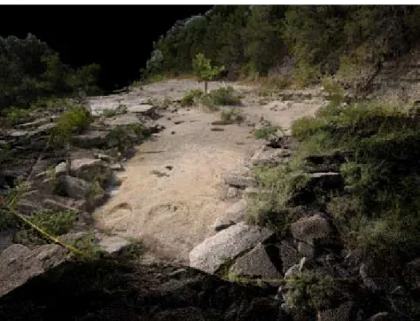
works perfectly! After Jim Farlow gave us a short tour around the sites on our first day at Glen Rose, it was mid‑day when we set up and far too hot for our long range scanner. Fortunately, we had brought a back up; a short range, hand-held laser scanner, which we’d tested earlier that Summer at the Red Gulch Dinosaur Tracksite in Wyoming (Fig. 1a). Although designed for indoor applications, with a little modification and high-tech environmental controls (Fig. 1a) the unit works really well in the field and produces very tidy high resolution scans of track surfaces (Fig. 1b-c). But to image the sites in their entirety we needed the long range scanner, complete with camera for full photographic coverage. So to beat the Texan heat we were in the field shortly after sunrise the next day to fit in as many hours scanning as possible before the mid‑day peak in temperature. These hours of modest heat allowed us to scan two sites at Glen Rose, including the main tracksite (Fig. 2).
On our final working day in Texas we drove south to Austin to TMM to scan the first of the two chase sequence slabs excavated by Bird’s team in the 1940s. Unfortunately, the nature of the slab (size, weight, etc.) has made it difficult to manage and conserve the trackway. This has meant its potential as a scientific and educational resource has not been met. The tracks at TMM were excavated as part of a 9 m × 3.65 m fragmented limestone slab and were reconstructed on the earthen ground outside the main museum and subsequently enclosed within a single-storey building. Deterioration of the TMM trackway was first reported in 1988. The deterioration, resulting in a loss of surface detail, has several sources. Moisture and soluble salts evaporating up from underlying soil were trapped by a coating of paint that was applied to the track surface during its consolidation in the
building. The salts broke down the stone from the inside out and the trapped moisture eventually lifted off the paint and the limestone attached to it. A leaking roof, windows and inadequate ventilation creates a humid environment ideal for the growth of stone damaging moulds. As of November 2008, a stone conservation specialist has been contracted to test the condition of the tracks and a report is due in 2009. Given that the public has never really seen or understood the significance of the tracks there was little public pressure to improve their conservation. If the conservation of the blocks at TMM is not successful, then the scans we collected (Fig. 3) will serve as the only 3D record of these important tracks. Given that the Paluxy tracks represent the best-preserved sauropod tracks in the world and have type status for the trace fossil Brontopodus birdi it
Figure 1. (a) Scanning dinosaur tracks using the hand-held Polhemus laser scanner. (b) Surfaced scan of a large tridactyl track from the bed of the Paluxy River. (c) Surface model of tridactyl tracks colour-coded and contoured according to depth.
is important that they are accurately recorded. Whilst it is important that the tracks are maintained for reference and comparative purposes, it is also essential they be preserved so that the scientific information they hold can be re-evaluated as new methods and analytical techniques become available.
Having scanned the TMM block, then came the daring part of our trip – the dash to the AMNH. Things began promisingly as our flight from Dallas departed on time and favourable weather meant a slightly early landing in newark. With six hours between our arrival at newark and the departure of the homeward flight to Manchester we calculated (or rather guessed) that we had around three hours for our new York escapade. Our equipment appeared timely on the conveyer belt and we headed hastily for a taxi outside the airport terminal. Minutes later we were speeding towards NYC.
Then came a question from our taxi driver: ‘Where exactly in nYC is the AMnH?’ Stunned silence. Our limited local knowledge (‘it’s next to Central Park’) did not impress the driver and his tolerance for two ignorant Brits became clear as he dropped us ‘around the corner’ from where he believed the AMnH to be. We were 12 blocks away. A second taxi got us and our half ton of scanning equipment to the Museum. Five hours until our homeward flight departure time, two hours to make check-in at newark on time. We fought our way through the Summer crowds (and Museum security) to the saurischian dinosaur gallery and the chase sequence slab, on display beneath the
Apatosaurus skeleton. Scanning took a mere half hour, a relieving anti‑climax, leaving us time to
answer questions from bemused on-lookers. Scrambling back into a taxi we returned to the airport with all the data in the bag and time to spare. Mission accomplished!
Figure 2. LiDAR scan of the main tracksite at Glen Rose. The image shows raw point cloud data, in which points have been colour-coded using images from the integrated digital camera.
To date, the data has been used mainly as an educational and conservation resource (Bates et al. 2009b). In particular, scans of the TMM chase sequence slab have proven particularly useful. It has formed part of a petition to TMM and the State of Texas to invest funds to restore, conserve and re-house the trackway before its deterioration becomes irrevocable. The chase sequence data has also been used in recent public engagement events, using the in-house software Virtual Reality Geological Studio (VRGS). VRGS was written to provide a platform for the integration and manipulation of quantitative digital outcrop data (e.g. LIDAR) and conventional field-work approaches (e.g. facies analysis and logging). The VRGS toolkit also includes a variety of functions specifically designed for rapid interrogation of digital models of vertebrate tracks and trackways, such as automated functions like the calculation of trackmaker speed from track length and stride length (Alexander, 1976). Displayed in VRGS, the digital model of Bird’s chase sequence has replaced a roll‑out paper trackway display formerly used to demonstrate to the public the kind of information that can be extracted about dinosaurs from their tracks. Whilst successful in the past, the old paper display required a significant amount of space and had to be regularly replaced after being torn by over‑enthusiastic members of the public keen to walk in the footsteps of the trackmaker. This allows the Museum visitor to go through a process of scientific discovery, literally step‑by‑step, learning how fast the predator may have been chasing its prey. The display is currently not stand-alone as VRGS requires operational guidance which at this time is not commercially available. However, the long term goal is a stand‑alone display communicating the new data generated about these unique tracks and the fascinating animals that made them.
Future work on the trackway data will largely focus on dinosaur locomotion, with specific emphasis on theropod trackways. Large tridactyl tracks from Glen Rose have been attributed to Acrocanthosaurus atokensis (Dinosauria: Theropoda). Detailed morphometric analyses have
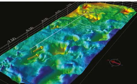
Figure 3. LiDAR scans of the Texas Memorial portion of Bird’s theropod-sauropod chase sequence, with selected foot length and stride length measurements shown. In VRGS the model’s surface can be presented in a variety of formats to highlight various features in the tracks. Shown here colour-coded according to depth (from Bates et al., 2009b).
shown a clear correlation between Paluxy theropod tracks and the pedal phalangeal proportions of Acrocanthosaurus (Farlow, 2001), supporting earlier interpretations of this animal as the track‑ maker based on qualitative morphological observations and the close stratigraphic occurrence of body fossils (Langston, 1974; Pittmann, 1989). The number and quality of large theropod tracks preserved at Paluxy River provides a unique opportunity to investigate the locomotor dynamics of
Acrocanthosaurus, one of the largest theropods known from near‑complete skeletal remains (Currie
and Carpenter, 2000; Bates et al., 2009a). To complement the study of the Glen Rose trackways, I have constructed a 3D musculoskeletal model of Acrocanthosaurus, which includes all body segment mass and inertial properties necessary to produce a forward dynamics physics simulation (Bates
et al. 2009a). Gait predictions from biomechanical modelling (e.g. speed, stride length, cost of
locomotion) will be compared to predictions from trackways, providing important new information on the locomotion dynamics of large theropod dinosaurs.
Acknowledgements
The Palaeontological Association is thanked for the Sylvester‑Bradley Award that helped fund this research, along with doctoral dissertation grants from the natural Environmental Research Council (UK) to K.T.B. (nER/S/A/2006/14101) and Peter Falkingham (nER/S/A/2006/14033), with additional funding to K.T.B. from the Jurassic Foundation. Peter Falkingham is thanked for his help in all aspects of this work, as are my PhD supervisors Bill Sellers and Phil Manning. Dave Hodgetts is thanked for his assistance with VRGS. Jim Farlow (Indiania-Purdue University) and Mike O’Brien (Texas Parks and Wildlife) are thanked for inviting us to work at Glen Rose, and for their hospitality and collegiality during the time in Texas, and John Maisano and Ed Theriot (TMM) and Carl Mehling (AMnH) for providing generous access to the Bird chase sequence slabs.
RefeReNCeS
ALExANDER, R. M. 1976. Estimates of speeds in dinosaurs. Nature, 261, 129–130.
BATES, K. T., MANNING, P. L., HODGETTS, D. and SELLERS, W. I. 2009a. Estimating mass properties of dinosaurs using laser imaging and 3D computer modelling. PLoS ONE, 4, e4532. doi:10.1371. BATES, K. T., FALKINGHAM, P. L., HODGETTS, D., FARLOW, J. O., BREITHAUPT, B. H., O’BRIEN,
M., MATTHEWS, N., SELLERS, W.I. and MANNING, P. L. 2009b. Digital imaging and public engagement in palaeontology. Geology Today, 25, 134–139.
CURRIE, P. J. and CARPENTER, K. 2000. A new specimen of Acrocanthosaurus atokensis (Theropoda, Dinosauria) from the Lower Cretaceous Antlers Formation (Lower Cretaceous, Aptian) of Oklahoma, USA. Geodiversitas, 22, 207–246.
FARLOW, J. O. 1993. The dinosaurs of Dinosaur Valley State Park. Texas Parks and Wildlife Department, Austin (Texas).
FARLOW, J. O. 2001. Acrocanthosaurus and the maker of Comanchean large-theropod footprints.
In TANKE, D. and CARPENTER, K. (eds). Mesozoic Vertebrate Life. Indiana University Press,
Bloomington, IN. p. 408–427.
LANGSTON, W., Jr. 1974. Nonmammalian Comanchean tetrapods. Geoscience and Man, 8, 77–102. PITTMAN, J. G. 1989. Stratigraphy, lithology, depositional environment, and track type of
dinosaur track-bearing beds of the Gulf Coastal Plain. In GILLETTE, D. D. and LOCKLEY, M. G. (eds). Dinosaur Tracks and Traces. Cambridge University Press, Cambridge, U.K. p. 135–153.