HAL Id: hal-00768755
https://hal-brgm.archives-ouvertes.fr/hal-00768755
Submitted on 23 Dec 2012
HAL is a multi-disciplinary open access
archive for the deposit and dissemination of
sci-entific research documents, whether they are
pub-lished or not. The documents may come from
teaching and research institutions in France or
abroad, or from public or private research centers.
L’archive ouverte pluridisciplinaire HAL, est
destinée au dépôt et à la diffusion de documents
scientifiques de niveau recherche, publiés ou non,
émanant des établissements d’enseignement et de
recherche français ou étrangers, des laboratoires
publics ou privés.
Geothermal exploration in the Mount Pelée
volcano-Morne Rouge and Diamant areas (Martinique,
West French Indies) : Geochemical data
Bernard Sanjuan, Millot Romain, Brach Michel, Jean-Claude Foucher,
Jean-Yves Roig, Jean-Michel Baltassat
To cite this version:
Bernard Sanjuan, Millot Romain, Brach Michel, Jean-Claude Foucher, Jean-Yves Roig, et al..
Geother-mal exploration in the Mount Pelée volcano-Morne Rouge and Diamant areas (Martinique, West
French Indies) : Geochemical data. World Geothermal Congress 2005, Apr 2005, Antalaya, Turkey.
12 p. �hal-00768755�
Antalya, Turkey, 24-29 April 2005
Geothermal exploration in the Mount Pelée volcano-Morne Rouge
and Diamant areas (Martinique, West French Indies): Geochemical data
Bernard Sanjuan, Romain Millot, Michel Brach, Jean-Claude Foucher, Jean-Yves Roig and Jean-Michel Baltassat
BRGM - 3, Av. Claude Guillemin - 45060 ORLEANS Cedex 02 - France b.sanjuan@brgm.fr
Keywords: Martinique, geothermal exploration, thermal
springs, soil gas profiles, chemical geothermometers
ABSTRACT
The increasing demand for energy in the Caribbean islands and the aim to enlarge energy autonomy have resulted in starting again geothermal research on the Martinique island, in the Lesser Antilles. The first works, which were the drilling of three deep wells (1000 m) in the Lamentin plain in 2001, did not show the existence of high temperature geothermal resources. Consequently, new studies of geothermal exploration were carried out between 2001 and 2003 in two other areas which had already been noticed for their geothermal interest: Mount Pelée volcano-Morne Rouge and Diamant. These areas belong to the recent arc of post-miocene age. All the data obtained in water geochemistry during these studies have led to a better comprehension of the geothermal systems associated to the thermal springs known in these areas (less than 15). Sixteen soil gas profiles (CO2, CH4, O2, He) could be carried out in
July 2002 in the studied areas, which represents approximately 260 analyzed gas samples. Among these samples, 11 were selected in order to perform additional chemical and isotopic (13C, 3He/4He) analyses. The geochemical results obtained during these studies made it possible to select three areas of high temperature geothermal interest: 1) the area of the thermal spring of Petite Anse du Diamant, whose the relatively saline water (TDS ≈ 20 g/l) and the CO2 gas emanations indicated high
temperature conditions (around 180 °C) at depth, despite a low flow rate and temperature (35°C) at the emergence. 2) the area of the upper Chaude river, where the chemical and isotopic compositions of the waters collected from the thermal springs (TDS from 1.0 to 1.5 g/l, the hottest temperatures at the emergence in the island: from 38 to 65°C) suggested the existence of a deep geothermal reservoir at about 200 °C and the presence of primarily magmatic CO2 gas. The deep hot water is after diluted and
cooled by superficial fresh waters, during its rise. 3) the area of the Desgrottes drill-hole, where the gas emanations testified of a magmatic origin but where no index of deep hot water was observed at the surface. For these three areas, results obtained from geological and geophysical studies supported the geochemical data. However, only the drilling of several deep exploration wells will be able to confirm the existence of workable high temperature geothermal resources in these areas.
1. INTRODUCTION
Geothermal research on the Martinique island, in the Lesser Antilles (French West Indies), has been started again in order to answer to the increasing demand for energy and to enlarge energy autonomy. After the drilling of three deep exploratory wells (1000 m) in the Lamentin plain in 2001, which only showed the existence of low temperature geothermal resources (90-120°C; Genter et al., 2002;
Sanjuan et al., 2002), a new geothermal exploration program was conducted by BRGM between 2001 and 2003 in two other areas already known for their geothermal interest: Mount Pelée volcano-Morne Rouge and Diamant (Lopoukhine et Mouret, 1977; Iundt, 1984; Barat, 1984; Traineau et al., 1989; Zlotnicki et al., 1998; Sanjuan et al, 2003a).
These works, including geological, geochemical and geophysical studies, were carried out in order to detect high temperature geothermal resources. The objective of this paper is to present and to discuss the main geochemical results obtained in these studies.
2. GEOLOGICAL BACKGROUND
Martinique is a volcanic island belonging to the Lesser Antilles arc, which draws an 850 km length curve. The two studied areas (Mount Pelée volcano-Morne Rouge and Diamant) are located in the northern and southern parts of the island, respectively (Fig.1). They belong to the recent arc of post-miocene age.
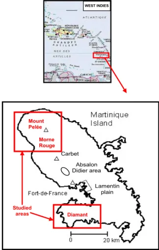
Figure 1: Location map of the Martinique island.
WEST INDIES Lamentin plain Absalon Didier area Carbet Diamant Morne Rouge Studied areas Mount Pelée
The surface geology is known from the 1:50,000 geologic map (Westercamp et al., 1989).
The Mount Pelée volcano has been edified in three stages, which have their own characteristics and emission point (Traineau et al., 1989). During the first stage dated to about 0.3-0.4 My, the primitive volcano was built (Vincent et al., 1989). It is mainly composed of indurate volcanic breccias, interpreted as brecciated lava flows and of scarce thick lava flows. Then took place a period of quiescence and erosion of at least 0.1 My.
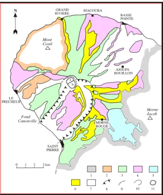
Figure 2: Geological scheme of the Mount Pelée volcano (In Sanjuan et al., 2003a). 1: Substratum of the Pitons du Carbet and Morne Jacob; 2: Mont Conil formations; 3: Mount Pelée - initial stage; 4: Pelée - intermediate stage; 5: lacustrine deposits; 6: Pelée - recent stage (from 13,500 to 5,000 years B.P.); 7: Pelée - recent stage (less than 5,000 years B.P.); 8: rim of the collapsed caldera defined by Vincent et al. (1989); 9: rim of the Macouba caldera; 10: rim of the Etang Sec caldera; 11: historical dome of lava (1902-1905; 1929-1932).
The second stage (> 40,000-20,000 years B.P.) corresponds to the emplacement of numerous scoria flows issued from column collapses. The deposits filled the deep valleys formed by erosion. Morne Macouba caldera was probably formed during this period. A major flank collapse event took place during this stage (25,000 years B.P. or before). It produced a horseshoe-shaped structure, 3.5 km wide and 6 km long, on the southwestern flank of the volcano opened toward the Carribean Sea (Fig. 2). A major sea floor drop followed by the accumulation of volcanic products on the SW volcano slopes presumably caused this (Vincent et al., 1989). The morphological rim oriented NE-SW from Saint Pierre to Morne Rouge is, presently, interpreted as the southern limit of the horseshoe-shaped structure. During recent works of structural geology, no evidence of tectonic fracturation was observed in this area (Gros, 2002). The intermediate edifice is the result of the formation of a new volcano in the middle of the horseshoe-shaped caldera, dominated by explosive events (Fig. 2).
The third stage started after a period of quiescence (20,000-14,000 years B.P.). It built the upper part of the new cone of Mount Pelée inside the horseshoe-shaped structure. Two types of eruptions occurred: pumiceous plinian eruptions (plinian fallouts and ash and pumice flows) and dome-forming eruptions with associated block- and ash-flows, and “pelean nuées ardentes”. During the last 14,000 years, 25 magmatic eruptions at least were evidenced by Traineau et al. (1983). Several lava domes, including Aileron, were built in the upper part of the horseshoe-shaped structure (Fig. 2). The two younger domes (1902 and 1929) filled the summit Etang Sec caldera, probably formed during the last pumiceous event (650 years B.P.). The geological formations of the old edifice are estimated rather as impermeable whereas those of the intermediate and recent edifice are considered as being permeable.
During the formation of the early Mount Pelée volcano, volcanic sandstones and clays were deposed in the neighboring Champflore basin (Fig. 2). According to Sanjuan et al. (2003a), this area is a depressive basin or graben with faults orientated NW-SE and N-S, and whose the formation would be dated to about 1 My. It is very difficult to do structural measurements in this zone because of the bad conditions of outcrop. No recent volcanic activity is associated to the formation of this basin. Few evidences of hydrothermal activity were found in this area.
In the Diamant area, the Morne Jacqueline and Morne Larcher volcanoes are the evidences of an eruptive cycle (2.6 My), which spread out from the Anses Marlet (NW) to Diamant (SE). After, the volcanic activity resulted in an effusive cycle with andesitic lava flows (2.2 My). The more recent products of the volcanic activity in this area have been dated to 0.9 My (massive andesitic lavas, phreato-magmatic breccias). Only three vertical and normal faults oriented N160-N170E with an horizontal extension of 2 km were identified in this area (Fig. 3). Presently, they form a 500 m large channel.
3. THERMAL SPRINGS
The thermal springs are scarce in the Martinique island in relation to the volcanic activity and the rainfalls. Less than 15 thermal springs were found in the studied areas. Except the Lamentin plain, where the thermal manifestations were previously studied (Sanjuan et al., 2003a), the most numerous and hottest springs are situated on the western flank of the Mount Pelée volcano. Most of these manifestations were previously studied by Lopoukhine and Mouret (1977), Barat (1984), Iundt (1984) and Traineau et al. (1989).
In order to select areas of high temperature geothermal interest, it was necessary to validate the previous data and to obtain additional results concerning some specific isotopes (3H, 13C, 34S and 18O of the dissolved sulfate,
87Sr/86Sr, 11B, 7Li) and trace elements. Fieldwork to
discover new thermal springs was done in the studied areas.
3.1 Fluid sampling
Fluids from 12 thermal springs located in the areas of Mount Pelée volcano and Petite Anse du Diamant (Figs. 3 and 4; Table 1a) were collected. Among the thermal springs previously studied, 3 springs of Chaude river (MP4, MP5 and MP7), 1 spring of Mitan river (MP9), 1 spring of Picodo river (MP10) and 2 emergences of the spring of Petite Anse du Diamant (DIAM1 and DIAM2) were sampled. 4 thermal springs were sampled for the first time.
Figure 3: Location maps of the thermal springs and superficial waters sampled during this study.
The results of physico-chemical parameters measured on site such as temperature, conductivity at 25°C, pH, Redox potential (Eh) and alkalinity are reported in Table 1a. Absolute uncertainty on the measurements of temperature and pH is 0.1°C and 0.05 unit pH, respectively. For the other parameters, relative uncertainty is about 5%. The samples were conditioned on site according to the required specifications for analyses (Sanjuan et al., 2003b).
The thermal springs of Chaude river are situated in a gorge of the upper Chaude river, at an elevation of 600-620 m and less than 1 km from the summit domes, with temperatures ranging between 28 and 65°C. Barat (1984) estimated their total discharge in the river to be about 20 l s-1. From a structural point of view, these springs emerge above the concealed southern limit of the intermediate caldera, which is thought to act as a conduit for upflows of thermal fluids. These hot springs appeared after the 1902-1905 magmatic eruption. Since 1960, they are monitored by the Observatoire de Physique du Globe du Morne des Cadets (OPGMC), which has observed that the temperature at their emergence tends to decrease after 1970. As their dissolved chloride concentrations also decrease, it can be suggested that the proportions of cold superficial fresh water in the deep hot fluid are became more significant. The highest
temperature measured at the emergence of the springs of Chaude river was 51,4°C in this study (table 1a; instead of 65°C in the past).
The thermal springs of Mitan and Picodo river were reached with difficulty because of their location. Several thermal springs occur along these rivers, issuing from pyroclastic deposits that lie on impermeable rocks of the early volcano. Temperatures range from 25 to 30°C for the springs of Mitan river and up to 38°C for the springs of Picodo river. The rate of discharge is unknown but probably low. Among the many emergences, only the hottest and most saline fluids of the springs of Mitan and Picodo river were collected (MP9 and MP10, respectively). The fluid sampled from the spring of Picodo river was more saline than in the previous studies (Sanjuan et al., 2003a).
The thermal springs, first reported in 1968, situated near the coast, near and in the Claire river are related to a shallow heated aquifer which discharges mainly into the Claire river after rain. The maximum recorded temperature comes from a 6 m deep well near the mouth of the Claire river (47°C) and from a hot spring emerging on a beach (36°C). These waters exhibit evidence of contamination by sea water, with an increase in Cl and Na concentrations. In this study, the 6 m deep well was replaced by a neighboring 10 m deep drill-hole (MP1 fluid), belonging to the OPGMC and used for fluid and temperature monitoring. The fluid temperature measured in this drill-hole was 36.4°C (table 1a) and is lower than that determined for the 6 m deep well.
The thermal spring of Petite Anse du Diamant, located near sea, at the foot of Morne Jacqueline and at the west of the beach of Petite Anse du Diamant, has several emergences. These emergences are situated at the foot of a relief constituted of volcanic formations belonging to a final stage of a plio-quaternary eruptive cycle (Westercamp et al., 1989). These formations are andesitic dome and flows, ashes and scoria dated to 2-2.2 My. They are above an older substratum represented by dacite with quartz and hornblende (4 to 5.5 My). The more recent andesitic formations in this area, present in the Morne Jacqueline and Larcher, are dated to 0.9 My. Hydrothermal deposits constituted of calcite, iron hydroxides, amorphous silica and sulfates (gypsum, jarosite) are formed during the cooling, degassing and oxidation of the fluids at the emergences of this spring. The total flow rate of this spring is about 0.5 l/s and the highest temperature at the emergence is 35°C. A similar temperature was measured at the main emergence in this study (DIAM1; table 1a). The DIAM2 fluid collected in another emergence was less hot and saline than DIAM1.
The thermal springs sampled for the first time were: two submarine springs (MP2 and MP3), a spring of Claire river in its upper part (MP8) and a spring of Grande river (MP11).
The two submarine thermal springs were sampled with the help of scuba divers of the TROPICASUB association. A motorboat equipped with a peristaltic pump, a plastic tube and a funnel was used to collect the fluid samples. After that the funnel was installed above the emergence of the submarine spring by a diver, the thermal fluid was pumped up to the boat using the peristaltic pump. The continuous measurement of temperature, conductivity and pH allowed to start the fluid sampling (after stabilization of conductivity and pH values lower than those of sea water).
The thermal springs of upper Claire and Grande river were reached with much difficulty because of their dangerous
Diamant area Thermal spring Superficial waters Rainfall DIAM3 Pond Torrent Water barrage DIAM4
Mount Pelée area
SW River MP6 Drill-hole OPGMC MP1 Submarine spring MP1 Submarine spring MP2 Thermal spring Surface water Seawater
location. Grande river is the only spring discovered on the north flank of the Mount Pelée volcano. The low temperature and conductivity of the fluids collected from these two springs suggest the presence of significant proportions of cold superficial waters.
Local superficial waters were also sampled (Fig. 3): river water (MP6), rain water (DIAM3), barrage water (DIAM4) and sea water (SW).
3.2 Fluid analyses
With the exception of the isotopic 14C and 13C analyses, which were performed in the Beta Analytic laboratory (Florida, USA), all the chemical and isotopic analyses were carried out in the BRGM laboratories, at Orleans. These were performed using standard water analytical techniques such as titration, potentiometry, colorimetry, ion electrode, atomic absorption spectrophotometry, ion chromatography, inductively coupled plasma-mass spectrometry (ICP-MS), ICP-MS-MultiCollector and mass spectrometry. The precision of major and trace species is better than ± 5 and 15%, respectively. The precision on δD, δ18O values and 3H activity is ± 0.8‰, ± 0.1‰ and ± 1 UT, respectively. That determined on the 87Sr/86Sr isotopic ratio, δ34S and δ18O of the dissolved sulfate, δ13C, δ11B and δ7Li is ± 0.00001, ± 0.3‰, ±0.3‰, ±0.1‰, ±0.2‰ and ±0.5‰, respectively. Relative uncertainty on the analysis of 14C activity is around 1 to 2%. Ion balance values lower than 5% suggested a good quality of the analyses of the dissolved major species. Results are reported in Tables 1a, 1b and 1c.
3.3 Fluid chemical characteristics
Despite some little differences, the chemical compositions of the fluids collected from the thermal springs of Petite Anse du Diamant and Chaude river are similar to those previously determined (Sanjuan et al., 2003a). The fluid sampled from the thermal spring of Mitan river during this study indicates concentrations of dissolved sodium, potassium, chloride and bicarbonate about two times higher than those previously determined whereas the concentrations of dissolved calcium, magnesium and sulfate are lower (Sanjuan et al., 2003a). This fluid sample seems to have a deeper signature. The chemical composition of the fluid collected from the thermal spring of Picodo river is different from the previous data (Sanjuan et al., 2003a).
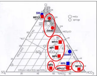
In the ternary diagram of the figure 4, five chemical types of thermal fluids can be distinguished.
Figure 4: Position of the thermal fluids in a ternary Cl-HCO3-SO4 diagram (Giggenbach, 1991).
The group of Petite Anse du Diamant is constituted of
NaCl type and CO2 rich thermal fluids (DIAM1 and
DIAM2), which have a high salinity (12-20 g/l) and pH values from 6.0 to 7.1. They can be considered as mature fluids having interacted with volcanic rocks (Fig. 4).
The group gathering the OPGMC drill-hole and thermal springs of Mitan and Picodo river (MP1, MP9
and MP10 fluids, respectively) represents Na-HCO3-Cl
fluids, which have a salinity ranging from 0.6 to 1.6 g/l and are near neutral in pH (6-7). Their chemical composition suggests a low contribution of sea water (< 2.5 %) before interaction with volcanic rocks. The differences in temperature and salinity of the numerous springs of Mitan and Picodo river can be explained by mixing between a deeper thermal fluid and cold superficial waters. The fluid collected from the thermal spring of Picodo river seems to be less affected by this mixing process.
The group of Chaude river is constituted of Na-HCO3 and
CO2 rich thermal fluids (MP4, MP5 and MP7), which have
a salinity ranging from 1 to 1.4 g/l and are near neutral in pH (6-7). Their chemical characteristics reflect mixing between a hot deep fluid and cold superficial fresh waters. The most saline fluid (MP4) also indicates the hottest temperature and the lowest pH. This fluid is less affected by mixing processes with cold superficial waters than the MP5 and MP7 fluids.
The group of upper Claire river is represented by an only
fluid sample (MP8), which is a Na-HCO3-SO4 water and
has a low salinity of 0.4 g/l. These characteristics rather belong to a superficial water. However, the relatively high concentration of dissolved sulfate could be originated by the presence of H2S rich steam or H2S gas emanations.
The fifth group (Grande river) is also constituted of an
only fluid sample (MP11), which is a Na-HCO3 water and
has a low salinity of 0.4 g/l. As for the previous fluid sample, these data are rather characteristic of a slightly warm superficial water.
The fluids sampled from the two submarine thermal springs (MP2 and MP3) are close to sea water because they are constituted of significant proportions of sea water and the other fluid of the mixing is lowly saline.
3.4 Fluid origin and age
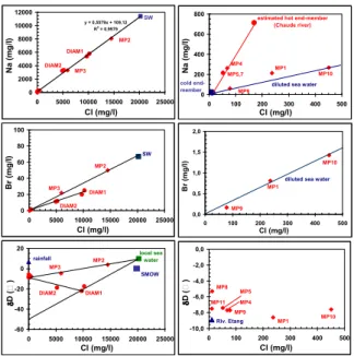
Chloride, bromide and sodium are conservative ions which can be often used as tracers of fluid origin or mixing as well as deuterium and sometimes, 18-oxygen isotopes.
The location of the submarine thermal springs, their temperatures at the emergence and figures 5 and 6 suggest that the MP2 and MP3 fluids are a mixing between sea water and the MP1 fluid. According to the concentrations of dissolved Cl, Br and Na, the proportions of sea water are about 72% for MP2 and 30% for MP3.
It can be also observed in these figures that the DIAM2 fluid results from a mixing between the DIAM1 fluid and a superficial fresh water. The location of the thermal spring of Petite Anse du Diamant, the relative high salinity of the DIAM1 fluid and the Na-Cl diagram (Fig. 5) suggest a marine origin for this fluid. However, the Br-Cl diagram (Fig. 5) is not in agreement with this origin except if bromide has been trapped (by organic matter?). Additional isotopic analyses of 36Cl and 37Cl would allow to accurately define the Cl origin. The δD value of the DIAM1 fluid, also analyzed by Iundt (1984) and Pedroni et al. (1999), is
exceedingly low in relation to the other values observed in the fluids of Martinique and the Lesser Antilles. Pedroni et al. (1999) noted that this value was hardly a feature inherited from recharge meteoric (or sea) water because the highest elevations in the surroundings are only 470 m above the sea level. Consequently, this low value could be explained by admixture of magmatic fluid (δD ≈ -80‰) or another component of up to now still unknown origin.
Figure 5: Na-Cl, Br-Cl and δD-Cl diagrams for the thermal fluids collected during this study.
Figure 6: δD-δ18O diagram for the thermal fluids collected during this study.
The figures 5 and 6 reveal that most of the other thermal fluids are constituted of local meteoric waters with similar isotopic signatures.
For the thermal springs of Chaude river, the figure 5 confirms that the MP5 and MP7 fluids are more affected by mixing with cold superficial waters than MP4.
The figure 5 suggests low contributions of sea water in the MP1, MP9 and MP10 fluids (close to 1, 0.4 and 2%, respectively, using the concentrations of dissolved Cl and Na). According to Barat (1984) and Traineau et al. (1989), the general volcanic structure of the Mount Pelée would favor superficial lateral outflow of the thermal fluid discharged in the upper area of Chaude river beneath the south and west flanks of the volcano, which would explain the location of the thermal springs encountered near the sea and the mouth of Claire river (6 m deep well, OPGMC drill-hole, coastal thermal spring) as well as the chemical composition of their fluids. The presence of this lateral outflow is a possible explanation of the gravity and
resistivity anomalies detected on the lower flank of the volcano by Benderitter (1987). Its existence was demonstrated by the distribution of a positive Self-Potential (SP) anomaly (Zlotnicki et al., 1998). The weakness of its amplitude expresses that either the water table belonging to the hydrothermal system is of small volume, or that the thermal exchanges with the surface are difficult due to the strong argillization of the deposits along the interface of the horseshoe-shaped structure and/or along the floors of the different calderas.
Traineau et al. (1989) also suggested that the fluids of the thermal springs of Mitan and Picodo river could be partly fed by this lateral outflow coming from the upper area of Chaude river. However, no geochemical data allows to maintain this assumption.
The samples of superficial waters (DIAM4 and MP6) have an 3H activity equal to 2 TU whereas the 3H activity measured on the sample of rain water (DIAM3) is < 1 TU (Table 1c). In these conditions, it is difficult to interpret the values found for the DIAM1, DIAM2, MP9 and MP10 fluid samples, which also are < 1 (age older than 50 years or very recent?). However, it is probable that the age of these thermal waters is older than 50 years. The age of the MP1, MP4 and MP11 fluids (3H = 2-3 TU) is rather recent and in any case, younger than 50 years.
The 14C activities and the δ13C values analyzed in the samples of surface fresh waters (DIAM4 and MP6) confirm that these waters are present (Table 1c). Processes of carbon isotope exchange most likely play a decisive role in hydrothermal systems. The application of 14C exchange dating for local conditions cannot elucidate the ages because isotope exchange processes happen very quickly at high temperatures in the water-rock-gas system. For the DIAM1, MP1, MP4 and MP5 fluids, the ages estimated using 14C activities cannot be considered as representative because these activities are strongly influenced by the dissolution of carbonate minerals or magmatic CO2 (null 14
C activity), as indicated by the δ13C values (Table 1c, see next chapter). The δ13C values also suggest that the proportions of superficial water increase from MP4 to MP5 and from MP5 to MP1.
3.5 Water-rock-gas interaction processses
3.5.1 Thermal spring of Petite Anse du Diamant
Compared to a sea water diluted by fresh water, the fluids of the thermal spring of Petite Anse du Diamant (DIAM1 and DIAM2) are enriched in Ca, HCO3, SiO2, Sr, Ba, B, As,
Fe, Mn, Li, Rb, Cs and Ge. They are depleted in Mg and SO4 (Fig. 7). These results are characteristic of interaction
processes between sea water and volcanic rocks (basalts, andesites…), which have been observed in laboratory and in natural environment (Sanjuan et al., 1990).
Figure 7: Li-Cl and Mg-Cl diagrams for the thermal fluids collected during this study.
-60 -40 -20 0 20 -10 -5 0 5 10 δD ( ) δ18 O ( )
mondial meteoric water line: y = 8x + 10 local meteoric water line:
y = 8x + 16
SMOW
DIAM2
local sea water
rain DIAM1 y = 0,5579x + 109,12 R2 = 0,9979 0 2000 4000 6000 8000 10000 12000 0 5000 10000 15000 20000 25000 Cl (mg/l) N a (m g /l ) DIAM1 SW DIAM2 MP3 MP2 -60 -40 -20 0 20 0 5000 10000 15000 20000 25000 Cl (mg/l) δD ( ) SMOW local sea water DIAM2 rainfall DIAM1 MP2 MP3 0 20 40 60 80 100 0 5000 10000 15000 20000 25000 Cl (mg/l) B r (m g /l ) SW DIAM2 MP3 MP2 DIAM1 0,0 0,5 1,0 1,5 2,0 0 100 200 300 400 500 Cl (mg/l) B r (m g /l ) MP10 MP1 MP9
diluted sea water
0 200 400 600 800 0 100 200 300 400 500 Cl (mg/l) N a (m g /l )
estimated hot end-member (Chaude river) cold end-member MP10 MP1 MP9 MP4 MP5,7
diluted sea water
-10,0 -8,0 -6,0 -4,0 -2,0 0,0 0 100 200 300 400 500 Cl (mg/l) δD ( ) MP10 MP1 Riv. Etang MP8 MP11 MP9 MP5 MP4 0 5 10 15 0 5000 10000 15000 20000 25000 Cl (mg/l) L i (m g /l ) DIAM1 SW MP3 MP2 DIAM2 0 500 1000 1500 2000 0 5000 10000 15000 20000 25000 Cl (mg/l) Mg ( m g /l ) DIAM1 DIAM2 MP2 MP3 SW
The existence of a significant 18O enrichment from the rocks (Fig. 6), already observed by Iundt (1984) and Pedroni et al. (1999), confirms that the DIAM1 fluid has a strong interaction with the rocks at relatively high temperature. This shift is attributed to hydrothermal water-rock isotope exchange. However, it could also traduce the existence a low water-rock ratio or fluid circulation rate. This 18O enrichment is in good agreement with the high concentrations of dissolved silica, lithium, boron and arsenic and as we shall see it, with the estimated deep temperature.
The Cl/B ratio values measured on these samples vary from 119 to 130. They are much lower than for sea water (≈ 5260) and close to the values generally determined for most of the geothermal waters (from 10 to 100). The B concentrations of these samples and their isotopic B signature (Table 1c) suggest a gaseous B origin (between 2 and 8‰ for fumarole vapors; Mossadik, 1997). The Cl/Li ratio values (from 861 to 1010) are also much lower than for sea water (≈ 87826) and suggest a strong interaction with the volcanic rocks at relatively high temperature.
The 87Sr/86Sr values of these fluids (Table 1c) are close to those measured on volcanic rocks (andesite, basalt…) and consequently, testify of a strong interaction with these rocks. However, these values slightly higher than those analyzed on the fluid samples collected from the thermal springs of Chaude river, which are merely meteoric waters, could be an evidence of the sea water contribution (87Sr/86Sr = 0.709188) that feeds the thermal spring of Petite Anse du Diamant. The δ34S value of these fluids (Table 1c) is very different from that analyzed for primary sulfur minerals (0‰). It is close to that measured for the arc andesites (from 0 to 12‰; Taylor, 1986).
The δ13C values of these fluids (Table 1c) are not in equilibrium with the δ13C value measured in the gas emanations (δ13C = - 4.4‰ in this study) associated to this thermal spring, that testifies of a mainly magmatic origin (-8.6‰ < δ13C < -2.4‰; Faure, 1986). Higher δ13C values (-3.08 to -2.70‰) were measured in the thermal fluids by Pedroni et al. (1999). These values are more in agreement with those determined in the gas emanations. The high alkalinity values and δ13C found in this study suggest that marine carbonate minerals can have been dissolved during the rise and cooling of these fluids. As shown by the deposits observed at the emergences of this thermal spring, this dissolution process is after replaced by calcite precipitation after degassing. Calculations performed using the geochemical EQ3NR code (Wolery, 1992) indicate that partial CO2 pressure (PCO2) is close to 1.25 bar at the main
emergence and show that the thermal fluid is saturated with respect to calcite, disordered dolomite and strontianite. It is over-saturated with respect to chalcedony, main clays and zeolites. This is in agreement with the mineralogical observations. The PCO2 value is probably higher because
degassing occurs at the emergence. A simulation run performed from 35 to 200°C using the geochemical EQ6 code (Wolery and Daveler, 1992) and assuming equilibrium between thermal fluid and calcite at any temperature shows that the PCO2 value is close to 4-5 bar (pH of about 5.35) at
the deep conditions.
3.5.2 Thermal springs of Chaude river
The fluids of these springs show a relatively high water-volcanic rock interaction degree. Indeed, they have the lowest values of Cl/B, Cl/Li, Cl/Cs, Cl/Rb, Cl/As and Cl/Ge ratio among the studied thermal springs. For example, the
Cl/B and Cl/Li values are about 30-40 and 40-50, respectively. Their isotopic δ11B, δ34S and Sr values (Table 1c) are in agreement with this process of strong interaction.
Calculations performed using the geochemical EQ3NR code indicate that the minimal PCO2 value is 0.34 bar at the
emergence of these springs and show that the thermal fluids are under-saturated with respect to the main carbonate minerals. This under-saturation can be explained by the fact that all these fluids are issued from a mixing between a deep hot mineralized fluid saturated with respect to calcite and cold superficial fresh waters.
The δ13C values reported in Table 1c can be used to
estimate the δ13C value of the CO2 emanations associated to
the emergences of these thermal springs. The reconstructed value (δ13C = -2.8‰) testifies of a magmatic origin but compared to the value directly analyzed in the CO2 gas
emanations associated to the thermal spring of Petite Anse du Diamant, it also suggests the presence of marine carbonate probably brought during the rise and cooling of the thermal fluids. An higher δ13C value (-4.2‰) was determined on the fluid of one of these thermal springs by Van Soest et al. (1998) in good agreement with the 3He/4He measurement (7.78 times the atmospheric ratio Ra). The
3
He/4He value was one of the highest measurements found by Van Soest et al. (1998) in the Lesser Antilles and is close to that of the helium from the upper mantle (8 times Ra).
Assuming that the deep hot fluid, which partly constitutes these thermal fluids, is in equilibrium with respect to quartz at 200°C (deep temperature determined using chemical geothermometers), its concentration of dissolved silica can be determined and the corresponding Cl concentration can also be estimated from the data reported in the SiO2-Cl
diagram (Fig. 8). Applying the mixing equation for the chloride concentrations on the MP4, MP5 and MP7 fluid samples, the dilution factor due to the mixing can be evaluated. For the MP4 sample, it can be estimated that the deep fluid is diluted by 60% of superficial fresh water; by about 70% for the MP5 and MP7 samples. The chemical composition of the deep hot fluid (Table 2) can be reconstituted for numerous species from linear regressions such as those shown in figures 5 and 8 and the Cl concentration determined for the deep fluid.
Figure 8: SiO2-Cl, HCO3-Cl, K-Cl and SO4-Cl diagrams for
the low salinity thermal fluids collected during this study.
This deep Na-HCO3 fluid has a probable salinity of 3-4 g/l.
A simulation run performed from 51 to 200°C using the geochemical EQ6 code and assuming equilibrium between
MP4
diluted sea water
MP10 MP1 MP5 MP7 MP9 Hot end-member (Chaude river) 0 50 100 150 200 250 300 0 100 200 300 400 500 Cl (mg/l) Si O2 ( m g /l ) MP10 estimated hot end-member
(Chaude river) MP1 MP9 MP7 MP4 MP5 cold end-member
diluted sea water
0 500 1000 1500 2000 0 100 200 300 400 500 Cl (mg/l) H C O3 ( m g /l ) MP10 MP1 MP9
estimated hot end-member (Chaude river)
MP5, 7 MP4
diluted sea water
0 20 40 60 80 100 0 100 200 300 400 500 Cl (mg/l) K ( m g /l )
estimated hot end-member (Chaude river) MP4 MP1 MP10 MP9 MP5 MP7 cold
end-member diluted sea water 0
100 200 300 400 500 0 100 200 300 400 500 Cl (mg/l) SO 4 ( m g /l )
estimated hot end-member (Chaude river) MP10 MP1 MP9 MP4 MP7
diluted sea water cold
this thermal fluid and calcite at any temperature shows that the PCO2 value is close to 2.5 bar (pH of about 7.0) at the
deep conditions.
3.5.3 OPGMC drill-hole and thermal springs of Mitan and Picodo river
All these thermal waters, originally constituted of a predominant contribution of meteoric water and a small proportion of sea water, are enriched in most of the chemical species relative to a diluted sea water (Fig. 8), except in Na and Br (Fig. 5). The enrichment in Mg and SO4 species (Fig. 8) suggests that these fluids have
significant proportions of cold superficial waters.
Calculations performed using the geochemical EQ3NR code indicate that the minimal PCO2 values are 0.09 and
0.12 bar respectively, in the OPGMG drill-hole and at the emergences of the MP9 and MP10 thermal springs. These values are inferior to those estimated for the thermal springs of Chaude river and suggest a lower degree of water-rock-gas interaction. Calculations also show that the thermal fluids are under-saturated with respect to the main carbonate minerals. As for the thermal springs of Chaude river, these under-saturations can be explained by the fact that all these fluids are issued from a mixing between a deep fluid saturated with respect to calcite and cold superficial waters.
The 87Sr/86Sr value determined for the MP1 fluid sample (Table 1c) is not close to those determined in volcanic rocks but is the result of a mixing between a fluid in equilibrium with these rocks and sea water. The contribution of sea water estimated from the mixing equation (1%), similar to that previously determined, confirms this assumption. This indicates that this mixture is not performed at high temperature. In opposite of the MP1 fluid sample, the
87Sr/86Sr values determined for MP9 and MP10 (Table 1c)
are similar and close to those determined in the volcanic rocks. They are slightly higher than those determined in the fluids of the thermal springs of Chaude river. This suggests that the MP9 and MP10 fluids come from a geothermal reservoir different from that feeding the thermal springs of Chaude river.
As for most of the studied fluid samples, the δ34S values determined on the MP1 and MP10 samples (Table 1c) are characteristic of arc andesites. The δ13C value estimated for the CO2 gas emanations associated to the MP1 drill-hole
was -5.6‰. This value obtained from the δ13C analyzed in the MP1 fluid testifies of a magmatic origin but when compared with the value directly analyzed in the CO2 gas
emanations associated to the thermal spring of Petite Anse du Diamant, it also suggests the presence of carbonate brought by superficial fresh waters (δ13C
atmosphere = -7.5‰,
δ13
C = - 14.8‰ for L’Etang river).
3.5.4 Thermal springs of upper Claire and Grande river
Even if these two thermal waters (MP8 and MP11, respectively) belong to two different chemical groups, their characteristics testify of slightly warm superficial fluids and low degree of water-rock-gas interaction.
3.6 Chemical geothermometers
The triangular diagram of the figure 9 indicates that all the thermal fluids are located in the area classified like that of the immature fluids, out of a full equilibrium with the rocks. However, the DIAM1 fluid, collected from the thermal spring of Petite Anse du Diamant, is very close to the area
of partial equilibrium. By applying the main chemical and isotopic geothermometers, a deep temperature of about 180°C is found for this fluid and DIAM2 (Table 3). Most of the geothermometers also give a deep temperature of 190-200°C for the fluids collected from the thermal springs of Chaude river and the OPGMC drill-hole. Similar deep temperature values were estimated in previous studies (Iundt, 1984; Traineau et al., 1989; Sanjuan et al., 2003a).
Figure 9: Position of the thermal fluids in a ternary Na-K-Mg diagram (Giggenbach, 1988).
For the fluids collected from the thermal springs of Picodo and Mitan river, a deep temperature close to 150°C is estimated (Table 3). The fluids sampled from the thermal springs of Claire river and Grande river are too much closer to the Mg end-member (Fig. 9), which characterizes the cold superficial waters, to determine a deep temperature.
According to Michard (1990), in volcanic environment, the dissolved silica is rather controlled by quartz at temperatures higher than 160°C and by chalcedony at lower temperatures. Given that most of the thermal fluids are diluted by cold superficial waters during their rise, the temperature values using the silica geothermometer are under-estimated.
For the MP8, MP9, MP10 and MP11 fluid samples, the deep temperatures estimated using the Na/K and Na/K/Ca geothermometers are not representative because the Na/K ratio is not controlled by the equilibrium reaction between the sodium and potassium feldspars, which is at the basis of the use of these geothermometers. For the MP2 and MP3 fluid samples, which contain a significant proportion of sea water, it is known that these geothermometers give bad temperatures (Giggenbach, 1988).
For the thermal CO2-rich fluids, that are partly constituted
of sea water, the Na/Li geothermometer of Kharakha et al. (1982) seems to be better adapted (Table 3) than that described by Fouillac and Michard (1981), which gives best temperature estimations for the thermal fresh waters.
A linear regression is observed between 150 and 200°C in figure 10 where the δ7Li values of the thermal fluids have been plotted as a function of the deep temperatures estimated using the geothermometers. The more temperature increases, the more δ7Li value is high. Figure 10 suggests that the thermal fluids of the springs of Picodo and Mitan river (MP10 and MP9, respectively), which have similar 87Sr/86Sr and δ7Li values, belong to a same geothermal reservoir where the deep temperature is close to 150°C. MP9 is more diluted by cold superficial fresh waters during its rise than MP10. Contrary to the
assumption supported by Traineau et al. (1989), the reservoir of these fluids would be different from that feeding the thermal springs of Chaude river (MP4 and MP5 fluids), whose the deep temperature is 190-200°C, the δ7Li value is higher and the 87Sr/86Sr ratio is lower.
On the other hand, the MP1 thermal fluid would come from this last reservoir (Fig. 10). It would be, after, diluted by cold superficial fresh waters during its rise and its lateral outflow up to the coastal emergences, and mixed with a small contribution of sea water. The δ7Li signature of the
reservoir fluid is conserved given the low concentrations of dissolved Li in the superficial waters and sea water relative to the reservoir fluid. The PCO2 value estimated for MP1,
lower than for MP4, is in agreement with a longer superficial fluid circulation (higher degassing).
The δ7Li value of the fluid collected from the thermal spring of Claire river (MP8) is similar to that measured for the superficial waters (MP6; Table 1c; Fig. 10) and seems to confirm the low temperature at which this fluid interacts with the volcanic rocks.
Figure 10: δ7Li-T diagram for some studied thermal fluids. We can conclude that the chemical geothermometers and δ7
Li values have allowed to clearly identify different geothermal reservoirs despite the complexity of the characteristics of some thermal fluids. Without these useful tools, it would have been very difficult to identify these reservoirs.
4. SOIL GAS PROSPECTING
Soil gas prospecting has received much attention in recent years as a useful tool for geothermal exploration. Studies carried out over active faults or fractures have shown that these geological structures act as preferential pathways for the discharge of gases such as CO2, CH4, He, Rn, etc.
Among these gases, He is probably the best indicator of deep discharge.
4.1 Selected areas
During the July 2002 survey, sixteen soil gas profiles were performed on selected areas of geothermal interest (Fig. 11). 260 soil gas samples were analyzed for CO2, CH4
and O2. He was only determined on selected samples.
4.2 Sampling and analytical methods
The soil gases were sampled at a depth of 0.5 m with a steel probe, equipped with a Teflon pipe and sunk in the ground with a sliding hammer. A gas sample was also directly collected from the Deux Choux drill-hole.
The measurements of CO2, CH4 and O2 were performed on
site using an infra-red apparatus LFG20 TELEGAN, that
simultaneously gave the percentages of volume of these three gases. Analytical accuracy is 0.5% for CO2 and CH4
and 0.4% for O2. The internal pump of this apparatus also
was used to sample the gases in Teflon bags TEDLAR for He analyses. He was determined using a specific mass spectrometer ALCATEL ASM 100. Analytical precision is 0.02 ppm.
Figure 11: Soil gas profiles carried out during this study.
Among the 260 analyzed gas samples, 11 were selected in order to perform additional chemical and isotopic analyses. The gas samples were collected in 250 ml glass flasks. The additional gas chemical analyses and δ13C measurements on CO2 gas were performed in the BRGM laboratories using
gas chromatography and mass spectrometry, respectively. For chromatography, analytical relative uncertainty was 3%. For spectrometry, analytical absolute accuracy was 0.1‰. The 3He/4He values were determined using mass spectrometry in the MAGIE laboratory (Magmatologie et Géochimie Inorganique et Expérimentale) of the Paris 6 University. Analytical relative uncertainty varied from 4 to 12% (Table 4).
4.3 Results and interpretation
All the data are reported in Sanjuan et al. (2003b). The results of the additional chemical and isotopic analyses are presented in Table 4. In this table, we can also notice that the analytical results obtained on site were confirmed in laboratory.
From all these data, two areas of geothermal interest can be determined.
The area of the Desgrottes drill-hole (depth of 32 m), where this drill-hole has crossed gas emanations under a cover of pumices and peat (Lopoukhine and Mouret, 1977), indicates the presence of magmatic gas emanations mixed to atmospheric and organic gases (high contents of CO2,
mixed 13C and 3He/4He signatures, O2 presence, N2/Ar ratio
close to the atmospheric ratio of 84). A similar chemical gas composition (51% CO2, 31% CH4 and 17% N2) had
been given by Lopoukhine and Mouret (1977). A comparable 3He/4He value (4.43 times Ra) had been measured by Pedroni et al. (1999) and is found in the emanations collected from the neighboring Deux Choux hole (Table 4; Pedroni et al., 1999). In this last drill-hole, the δ13C value of CO2 is similar to that determined by
Pedroni et al. (1999; δ13C = -6.37‰) but slightly higher than that measured for the Desgrottes drill-hole. The Desgrottes drill-hole also discharges a Na-Ca-HCO3 fluid,
which has a temperature of 28.6°C, a pH value of 6.7 and a salinity < 0.7 g/l (Lopoukhine and Mouret, 1977). The δD and δ18O values (-6.60 and -2.61‰, respectively), measured by Pedroni et al. (1999), indicate a meteoric origin for this fluid and are similar to those of the neighboring cold waters of the Champflore basin (-5.90 and -2.11‰, respectively). The chemical characteristics of this fluid and its low salinity suggest a predominant superficial origin and don’t show a significant high temperature geothermal interest.
0.0 2.0 4.0 6.0 8.0 10.0 0 50 100 150 200 250
Estimated deep temperature (T°C)
δ 7 L i v a lu e s ( ) MP5MP4 MP1 MP10 MP9 MP6 superficial water T? MP8 DIAM1 DIAM2
In the area of the thermal spring of Petite Anse du Diamant, the presence of significant magmatic gas emanations is also observed in and near this thermal spring, in hydrotermally altered soils (Table 4; high contents of CO2 and He, 13C and 3
He/4He signatures). For the thermal spring, Pedroni et al. (1999) had found 3He/4He values (from 7.75-7.93 times Ra) and δ13C slightly higher than those analyzed in this study. This confirms the significance of the magmatic signature in these superficial manifestations.
The 13C and 3He/4He analyzes performed in gas samples
collected from other areas, which indicate CO2 or He
anomalies (Roxelane river, Morne Calebasse, Camp Chazeau, Petite Savane, Ecrevisses river, Propriété De Paz, Table 4), suggest an organic origin for CO2 (δ13C values
from -26.1 to -16.1‰) or an atmospheric origin for He (3He/4He values close to Ra).
5. AREAS SELECTED FOR THEIR HIGH TEMPERATURE GEOTHERMAL INTEREST
Before and during the works of geothermal exploration performed in the Mount Pelée-Morne Rouge and Diamant areas, several geophysical anomalies were found (Figs. 12 and 13; Sanjuan et al., 2003a; Baltassat et al., 2003).
Figure 12: Map showing the main geophysical anomalies obtained in the Mount Pelée volcano-Morne Rouge area.
In particular, Magneto-Telluric (MT) soundings allowed to discover several conductive areas from the surface up to depths of 1000-1500 m on the southwestern flank of the Mount Pelée, in the Champflore tectonic basin (Fig. 12), between Les Anses d’Arlets and Petite Anse du Diamant or near Les Trois Ilets (Fig. 13). These conductive areas can be indicative of the existence of fluids but also clay minerals of hydrothermal alteration. For three of these areas (Champflore basin, Anses d’Arlets and Petite Anse du Diamant), lowly magnetic anomalies were also found (Figs. 12 and 13). Heavy gravity anomalies, which could result of the presence of a source of heat, were identified under four of these MT conductive areas (Roxelane river-Morne Rouge, Champflore basin, Anses d’Arlets and Petite
Anse du Diamant; Figs. 12 and 13). The convergence of these different geophysical anomalies could traduce the presence of a geothermal reservoir in these four areas.
Figure 13: Map showing the main geophysical anomalies obtained in the Diamant area.
However, among the areas of high temperature geothermal interest, only those where hydrothermal manifestations (discharges of deep waters or gases, hydrothermal deposits) were observed and confirmed by geochemical interpretation, were selected as priority to drill future exploration wells. These areas are:
- the coastal area of the thermal spring of Petite Anse du Diamant (Fig. 13) where numerous discharges of deep waters and gases and hydrothermal deposits are associated to the convergence of three geophysical anomalies (heavy gravity anomaly from a depth of 1000-1500 m, superficial conductive area up to a depth of 1000 m, lowly magnetic anomaly), which could traduce the presence of a geothermal reservoir at 180°C;
- the area of the upper Chaude river (Fig. 12), where several hot springs, located in the rims of the intermediate caldera of the Mount Pelée and near the sites of the main phreatic eruptions of 1792 and 1851, occur and suggest the existence of a geothermal reservoir at 190-200°C;
- the area of the Desgrottes drill-hole, in the Champflore basin (Fig. 12), where discharges of deep gases are observed and associated to the presence of three geophysical anomalies. Given that the formation of this basin and the corresponding faults oriented NW-SE and N-S are dated to 1 My and no discharge of hot water is observed, these areas seem to be of a lesser geothermal interest.
The area of the thermal springs located on the Caribbean seashore and near the mouth of Claire river, on the southwestern flank of the Mount Pelée (Fig. 12), was not selected as priority area. Indeed, the SP surveys of Zlotnicki et al. (1998) and the geochemical works of this study confirmed that these springs were partly fed by warm
superficial outflows along the northwestern rim of the horseshoe-shaped structure, coming from the thermal area of the upper Chaude river (Fig. 12).
6. CONCLUSION
In this study, several surveys of water geochemistry and soil gas were performed in the Mount Pelée volcano-Morne Rouge and Diamant areas. All the geochemical results were compared to the previous data as well as the new geological and geophysical results and interpreted in order to select zones of high temperature geothermal interest. After these studies, these zones will have to be validated by drilling deep exploration wells.
The geochemical characteristics of the thermal fluids and especially, the use of helpful tools such as the chemical geothermometers and isotopic 87Sr/86Sr and δ7Li values have allowed to identify and to distinguish several geothermal reservoirs in the studied areas. A geothermal reservoir at about 180°C was identified under the thermal spring of Petite Anse du Diamant. Another geothermal reservoir at 190-200°C is probably present under the thermal springs of the upper Chaude river, located in the rims of the intermediate caldera of the Mount Pelée. It also seems to feed the thermal springs situated on the Caribbean seashore and near the mouth of Claire river by lateral superficial outflows. This geothermal reservoir would be different from that feeding the thermal springs of Mitan and Picodo river, which would be only at a temperature of about 150°C and not interesting for our objective. The existence of the two high temperature geothermal reservoirs (temperatures higher than 180°C) is supported by geological and geophysical data. Among the thermal springs discovered during this study, the two terrestrial springs sampled for the first time (upper Claire river and Grande river) indicate slightly warm superficial fluids and then have not high temperature geothermal interest.
The soil gas and geophysical results suggest another area where a high temperature geothermal reservoir could exist (Desgrottes drill-hole, in the Champflore basin). However, this area is lesser geothermal interest than the two previous zones because of the old age of the formation of this basin and the absence of hot waters at surface.
In a first approach, the other areas where geophysical anomalies were discovered, were not selected because no superficial discharge of deep waters and gases was observed.
Acknowledgments
Financial support for this study was provided by Région and ADEME Martinique, European Union (FEDER) and the Research Division of BRGM. The authors are grateful to J.P. Viodé, Manager of the “Observatoire de Physique du Globe du Morne des Cadets”, for his pleasant collaboration and participation to the water geochemistry survey. They are indebted to the Association “Plongée Emeraude”, and particularly to G. Lalubie, who collected the fluids from the thermal springs of Mitan, Picodo, Claire and Grande river, very difficult to sample. They thank the Management of the “Rhumerie De Paz” for site facilities and the Management of the “Maison du Volcan”, especially M. Henry, for his collaboration during the soil gas survey.
REFERENCES
Baltassat, J.M., Miehe, J.M., Debeglia, N., Dupont, F., and Martelet, G.: Réévaluation du potentiel géothermique dans les régions de Morne Rouge-Montagne Pelée et du Diamant (Martinique). Etude géophysique, Rapport
BRGM n° RP-52548-FR, (2003), 60 p.
Barat, A.: Etude du rôle des eaux souterraines dans le mécanisme des éruptions phréatiques. Application à la Montagne Pelée de Martinique et à la Soufrière de Guadeloupe, Thèse 3éme cycle, Université de Bordeaux,
(1984), 232 p.
Benderitter, Y. : Recherche par géophysique d’indices peu profonds en géothermie haute énergie. Un exemple à proximité de la Montagne Pelée (Martinique), Bulletin
Société Géologique de France, III 8, (6), (1987),
1055-1061.
Faure, G. : Principles of isotope geology. Edited by John
Wiley and Sons, 2nd Edition, (1986), 589 p.
Fouillac, Ch., and Michard, G.: Sodium/lithium ratio in water applied to geothermometry of geothermal reservoir, Geothermics, 10, (1981), 55-74.
Fournier, R.O.: A revised equation for the Na/K geothermometer. Geothermal Research Council, 3, (1979), 221- 224.
Fournier, R.O., and Rowe, J.J.: Estimation of underground temperatures from the silica content of water from hot springs and wet-steam wells. American Journal of Science, 264, (1966), 685- 697.
Fournier, R.O., and Truesdell, A.H.: An empirical Na-K-Ca geothermometer for natural waters. Geochimica &
Cosmochimica Acta, 37, (1973), 1255-1275.
Genter, A., Traineau, H., Degouy, M., Correia, H., Mas, A., Patrier, P., Roig, J.Y., and Sanjuan, B.: Preliminary geological results of recent exploratory drillings in a geothermal fractured reservoir at Lamentin (French West Indies, Martinique), Proceedings, 27th Workshop
on Geothermal Reservoir Engineering, Stanford University, Stanford, CA (2002), 241-247.
Giggenbach, W.F.: Geothermal solute equilibria. Derivation of Na-K-Mg-Ca geoindicators, Geochimica &
Cosmochimica Acta, 52, (1988), 2749-2765.
Giggenbach, W.F.: Chemical techniques in geothermal exploration, In Applications of geochemistry in
geothermal reservoir development by F. D Amore,
(1991), 119-144.
Gros, Y.: Les failles actives à faible fréquence de rupture en surface en Martinique, Rapport BRGM-ANTEA, (2002), 79 p.
Iundt, I.: Réévaluation géochimique du potential géothermique de l’île de la Martinique, Rapport BRGM
n° 84 SGN 292 GTH, (1984), 21 p.
Kharaka, Y.K., Lico, M.S., and Law-Leroy, M.: Chemical geothermometers applied to formation waters, Gulf of Mexico and California basins, AAPG Bulletin, 66, 5, (1982), 588-595.
Kharaka, Y.K., and Mariner, R.H.: Chemical geothermometers and their application to formation waters from sedimentary basins. In Naeser and
McCulloch Editions, Springer-Verlad, New York,
Lopoukhine, M, and Mouret, C.: Etude géothermique des sources de la Martinique, Rapport BRGM n° 77 ANT
36, (1977), 32 p.
Michard, G.: Géothermomètres chimiques. Bulletin du
BRGM (2ème série), Section III, 2, (1979), 183-189.
Michard, G.: Behaviour of major elements and some trace elements (Li, Rb, Cs, Sr, Fe, Mn, W, F) in deep hot waters from granitic areas, Chemical Geology, 89, (1990), 117-134.
Mizutani, Y., and Rafter, T.A.: Oxygen isotopic composition of sulphates, 3. Oxygen isotopic fractionation in the bisulphate ion-water system. New
Zealand Journal of Science, 12, (1969), 54-59.
Mossadik, H.: Les isotopes du bore, traceurs naturels dans les eaux. Mise au point de l’analyse en spectrométrie de masse à source solide et applications à différents environnements, Thèse de géochimie, Université
d Orléans, (1997), 224 p.
Pedroni, A., Hammerschmidt, K., and Friedrichsen, H.: He, Ne, Ar, and isotope systematics of geothermal emanations in the lesser Antilles Islands Arc,
Geochimica & Cosmochimica Acta, 63, 3/4, (1999),
515-532.
Sanjuan, B., Michard, G., and Michard, A.: Origine des substances dissoutes dans les eaux des sources thermales et des forages de la région Asal-Ghoubbet (République de Djibouti), Journal of Volcanology &
Geothermal Research, 43, (1990), 333-352.
Sanjuan, B., Traineau, H., Genter, A., Correia, H., Brach, M., and Degouy, M.: Geochemical investigations during a new geothermal exploration phase in the Lamentin plain (Martinique, French West Indies),
Proceedings, 27th Workshop on Geothermal Reservoir
Engineering, Stanford University, Stanford, CA (2002), 198-205.
Sanjuan, B., Genter, A., Baltassat, J.M., Serra, H., Roig, J.Y., and Brach, M: Synthèse des connaissances concernant le potentiel géothermique des régions de Morne Rouge-Montagne Pelée et du Diamant (Martinique). Premiers travaux BRGM 2001-2003,
Rapport BRGM n° RP-52283-FR, (2003a), 140 p.
Sanjuan, B., Brach, M., and Foucher, J.C.: Réévaluation du potentiel géothermique dans les régions de Morne Rouge-Montagne Pelée et du Diamant (Martinique). Etude géochimique, Rapport BRGM n° RP-52547-FR, (2003b), 80 p.
Taylor, B.E.: Magmatic volatiles. Isotopic variation of C, H, and S, In Stable Isotopes in high temperature geological processes, Reviews in Mineralogy, 16, Mineralogical Society of America, (1986), 185-225. Traineau, H., Westercamp, D., Benderitter, Y.: Case study
of a volcanic geothermal system, Mount Pelée, Martinique, Journal of Volcanology & Geothermal
Research, 38, (1989), 49-66.
Van Soest, M.C, Hilton, D.R., and Kreulen, R.: Tracing crustal and slab contributions to arc magmatism in the Lesser Antilles island arc using helium and carbon relationship in geothermal fluids, Geochimica &
Cosmochimica Acta, 62, n°19/20, (1998), 3323-3335.
Vincent, P.M., Bourdier, J.L., and Boudon, G.: The primitive volcano of Mount Pelée. Its construction and partial destruction by flank collapse, Martinique.
Journal of Volcanology & Geothermal Research, 38,
(1989), 1-15.
Westercamp, D., Andreieff, P., Bouysse, P., Cottez, S., and Battistini, R.: Notice explicative, Carte géologique
France au 1/50000, feuille Martinique, BRGM,
Orléans, (1989), 246 p.
Wolery, T.J.: EQ3NR, A Computer Program for Geochemical Aqueous Speciation-Solubility Calculations, Theoretical Manual, User's Guide and
Related Documentation (Version 7.0), LLNL,
Livermore, California, (1992), 246 p.
Wolery, T.J., and Daveler, S.A.: EQ6, A Computer Program for Reaction Path Modeling of Aqueous Geochemical Systems, Theoretical Manual, User's
Guide and Related Documentation (Version 7.0),
LLNL, Livermore, California, (1992), 338 p.
Zlotnicki, J., Boudon, G., Viodé, J.P., Delarue, J.F., Mille, A., and Bruere, F.: Hydrothermal circulation beneath Mount Pelée inferred by self potential surveying. Structural and tectonic implication, Journal of
Volcanology & Geothermal Research, 84, 1-2, (1998),
73-91.
Fluid sample n° Sampling Temerg. Cond. 25°C pH Eh O2diss. Na K Ca Mg Cl Alkalinity SO4 NO3 SiO2 TDS B.I. Cl/Br
date °C mS/cm mV mg/l mg/l mg/l mg/l mg/l mg/l mg/l HCO3 mg/l mg/l mg/l g/l %
Thermal spring of Petite Anse du Diamant DIAM1 06/12/01 35.3 28.4 5.99 -23 0.22 5800 295 1100 300 10200 1679 500 < 1 131 20.1 4.14 408
Thermal spring of Petite Anse du Diamant DIAM1 25/03/01 34.0 23.8 6.15 -35 n.a. 5396 237 991 263 9730 1500 493 < 1 154 18.9 0.83 489
Thermal spring of Petite Anse du Diamant DIAM2 06/12/01 31.3 17.6 6.53 -53 1.70 3340 178 565 174 5200 1709 817 < 1 137 12.1 0.34 441
Thermal spring of Petite Anse du Diamant DIAM2 25/03/01 30.4 14.7 7.10 -55 n.a. 3253 161 594 175 5070 1700 760 < 1 151 11.9 1.57 457
Water barrage La Charmeuse DIAM4 07/12/01 26.6 0.158 6.76 230 3.38 19.8 4.2 5.5 4.0 23.6 50 3.1 < 0.1 26.3 0.14 1.43 > 118
Drill-hole OPGMC Bord de Mer MP1 07/12/01 36.4 1.38 6.55 -125 0.11 213 13.9 34.3 25.9 237 282 96.6 < 0.1 103 1.01 1.08 293
1st submarine thermal spring MP2 09/12/01 33.0 42.1 7.00 57 3.40 8060 240 299 872 14500 180 2311 < 1 26.6 26.5 -3.69 290
2nd submarine thermal spring MP3 09/12/01 36.0 17.7 6.65 -105 1.92 3320 103 141 362 5960 219 888 < 1 75.5 11.1 -3.38 271
Sea water SW 09/12/01 28.5 53.5 8.19 -32 2.23 11400 309 390 1200 20200 143 2626 < 1 0.19 36.3 -0.77 301
Thermal spring of Chaude river MP4 11/12/01 51.4 1.49 6.40 -43 0.50 263 25.5 35.9 13.5 68.1 621 153 < 0.1 143 1.33 -1.93 > 340
Thermal spring of Chaude river MP5 11/12/01 39.6 1.06 6.47 -63 1.92 220 21.6 31.6 12.1 51.5 531 121 < 0.1 134 1.13 0.14 > 258
L'Etang river (near a bridge) MP6 11/12/01 24.4 0.176 7.15 140 7.70 16.3 2.4 13.1 4.0 12.7 69 14.6 < 0.1 76.3 0.21 -2.26 > 64
Thermal spring of Chaude river MP7 16/07/02 38.0 1.09 6.58 n.a. n.a. 212 23.0 29.0 13.4 51.6 491 123 < 1 115 1.06 2.41 > 258
Thermal spring of Claire river MP8 11/03/03 22.9 0.356 6.23 -19 n.a. 24.0 3.9 35.7 8.5 12.3 97 78.0 < 0.4 133 0.39 1.04 > 123
Thermal spring of Mitan river MP9 14/03/03 28.3 0.637 6.29 222 n.a. 60.8 14.6 51.6 18.5 78.1 185 65.0 < 0.4 120 0.63 -2.48 473
Thermal spring of Picodo river MP10 16/03/03 36.6 2.15 6.37 -103 n.a. 268 33.3 95.4 50.6 451 440 60.5 < 0.4 181 1.59 1.04 316
Thermal spring of Grande river MP11 12/05/03 27.1 0.353 6.29 -68 n.a. 21.1 4.2 24.5 17.0 9.2 200 12.7 < 0.1 106 0.40 -2.39 > 920
Table 1a: Chemical results (major species) of the fluid samples collected from the thermal springs and superficial waters (river, rainfall, sea, etc.) located in the Mount Pelée volcano-Morne Rouge and Diamant areas, during this study.