HAL Id: halshs-02932852
https://halshs.archives-ouvertes.fr/halshs-02932852
Submitted on 8 Sep 2020HAL is a multi-disciplinary open access archive for the deposit and dissemination of sci-entific research documents, whether they are pub-lished or not. The documents may come from teaching and research institutions in France or abroad, or from public or private research centers.
L’archive ouverte pluridisciplinaire HAL, est destinée au dépôt et à la diffusion de documents scientifiques de niveau recherche, publiés ou non, émanant des établissements d’enseignement et de recherche français ou étrangers, des laboratoires publics ou privés.
LAND POSSESSION IN BELIZE, 1930S-1950S ODILE
HOFFMANN
Odile Hoffmann
To cite this version:
Odile Hoffmann. THE END OF THE EMPIRE FORESTRY? ISSUES OF LAND POSSESSION IN BELIZE, 1930S-1950S ODILE HOFFMANN. Didier Guignard; Iris Seri-Hersch. Spatial appropria-tions in Modern empires, 1820-1960. Beyond dispossession, Cambridge Scholars Publishing, pp.50-74, 2019, 978-1-5275-3669-2. �halshs-02932852�
C
HAPTER
T
WO
T
HE
E
ND OF THE
E
MPIRE
F
ORESTRY
?
I
SSUES OF
L
AND
P
OSSESSION IN
B
ELIZE
,
1930
S
-1950
S
O
DILE
H
OFFMANN
Introduction
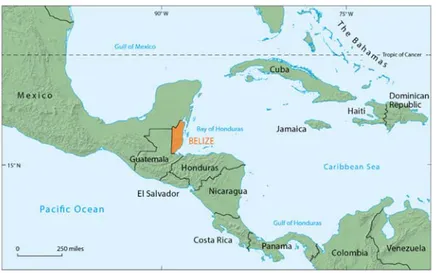
1The British Honduras (now Belize) located in Central America (Fig. 2.1) was, during its colonial period, initially a forest territory. During the 17th and 18th centuries, a number of Europeans, most of them British subjects, moved to the so-called “settlement”, which developed around the cutting of logwood, then mahogany and sapodilla, exploited for its gummy sap known as “chicle”. The country only officially became a British colony in 1862; it acquired “self-government” in 1964 and full independence in 1981.
Forest exploitation required specific governance of land and inhabitants. This governance was organised around particular means of labor (first slavery, then gangs made up of male workers), relations to space (cutting was carried out in areas viewed as wild, far from roads and towns)2 and time (logging was seasonal, in temporary camps), and social relationships featuring British
1 My thanks to Eric Léonard for his careful proofreading; any errors and
shortcomings are definitely my own. Translated by Anne-Marie Harper and by Esther Buddenhaggen.
2 The infrastructures remained very basic during a long time: “The road from
Belize city to Corozal near the Mexican border was not finished until 1938, and that of San Ignacio close to the western frontier would not been completed until after the Second World War” (Bulmer-Thomas 2012, 306).
domination of inhabitants from diverse backgrounds, all of whom were racialised (slaves, Creoles, Mayas, Garifunas, and so on). Forest entrepreneurs thus appeared as the first agents of the British Empire “in the field”, at the junction between the local companies that extracted wood, and Great Britain, which gleaned the profits. Among them, one company significantly dominated other companies in Belize: the Belize Estate Company (BEC), which logged great quantities of mahogany while maintaining its headquarters in London, where it kept close relations with government departments (i.e. the Colonial Office and other ministries). In the span of a few decades, the BEC accumulated considerable land assets in Belize that it sought to get rid of in the 1930s. The BEC’s lack of interest in these assets can be linked with several factors we shall analyse in this chapter: the decline of the mahogany economy, the internal political situation that was generating some restlessness in the territory and also the increasing competition with US investors that threatened British hegemony in Belize.
Most of these lands were located close to the border with Guatemala. The rearrangements resulting from transfers of property upset the fragile balance between the major stakeholders. These included companies, traders, administrators and politicians acting in different places (Belize, London) and at different levels (locally in the British Honduras settlement, in Great Britain, and internationally). The ensuing debates exposed strategic issues linked to the possession and control of forest areas. In this article, we propose to analyse colonial relations between a set of actors who at a given moment decided on the territory’s future. These relations will be examined through phenomena of land possession and dispossession. Several fields of action and intervention are directly concerned; we have identified three main ones.
The first is related to the institutions and standards that govern recognition of land possession and property. The BEC wanted to sell land for which it did not have title deeds. It therefore played on a register of legitimacy (rather than legality), mobilising a plurality of standards. This approach did not frontally oppose a legal system to a customary system, but rather pointed to slight differences and contradictions in each system and at their intersection. The second domain is that of forest policy, a particularly important aspect of British imperial policy at the time. The first British Empire Forestry Conference took place in London in 1920, followed by four more up to 1947 (Powell 2007). The immense forests of India, Asia, Australia and Africa were the focus of a great deal of attention and experiments (Barton 2001), and Belize, on a smaller scale, was part of this movement. Lastly, the third field that was strongly shaken by the BEC’s potential withdrawal from vast areas of land was that of national sovereignty. In the midst of World War II, at a time when the attitude of the Central American (and Mexican) governments towards Germany was not particularly clear, transferring property in a border zone immediately raised a global security issue: it could facilitate movements across the border and allow territories and people to escape from the control of the Allies in the region. We will see, however, that the British authorities were mostly preoccupied with their loss of power in the face of the inexorable rise of the United States. These three domains implied legal, political and economic action undertaken by stakeholders of varied status (private, public, corporations, individuals, etc.) acting at different scales of
governance, from the local level in Belize to the international arena. They were in fact highly dependent on the economic and geopolitical global changes that occurred from the beginning of the Great Depression until after the Second World War.
The argument begins by presenting the historical background and the main social and political actors before exploring these three fields of action. The analysis is based on archives consulted in Belmopan and London, including 20 years of correspondence between government departments in London (ministries, Colonial Office), the BEC and colonial institutions in Belize. These sources bear testimony to a wide range of actors, including intermediaries— experts, civil servants—for whom we lack precise profiles but who demonstrated a clear desire to influence decisions. By contrast, local inhabitants are remarkably absent from the archives, except towards the end of the period under scrutiny, when the company had to face the resentment of workers. Despite these limitations, the analysis reveals connections between imperial dynamics and local politics of population and space management. While the term “allochthonous” may be applied to British subjects and institutions acting in Belize, the word “autochthonous” is more difficult to use because colonised people came from very diverse geographical and historical backgrounds (see below). The term “popular” may be more appropriate to indicate the subordinate position shared by “common people” in Belize.
A Peripheral Colonial-Imperial Context
The government system in British Honduras followed an imperial-colonial model that may be qualified as hybrid. To begin with, in spite of its designation as such, the British Honduras was not really a “settlement”, although public policies did aim to attract slave labor and later free workers, who were mostly Chinese and Indian. In the eyes of the settlers and government, the settlement was perceived as an empty space, devoid of inhabitants despite the continued presence of some Mayas (natives) and Garifunas3 (who arrived in the
3 The Garifunas are descendants of Amerindians and Africans who escaped
slavery in the 17th century to the Caribbean island of Saint Vincent, where they developed a specific language and culture. At the end of the 18th
early 19th century). Nor was it exclusively a trading post, although the British government was only interested in it for economic reasons. In fact, the imperial power was interested in the territory partly because of its mahogany resources, and partly because of its geographical situation. It was the only continental portion that the British controlled in Central America, from which it had been chased out following the signature of international treaties at the end of the 18th century (Toussaint 1993, Bolland 2004, Hoffmann 2014). The local colonial society, for its part, witnessed few demographical and political changes for a long time. It bears the marks of its slave origins, with a Creole population (descendants of white masters and slaves) representing in the first half of 20th century the majority of a very diverse population that included Mayas, Garifunas, refugees from the Yucatan in the 19th century, descendants of Indian workers and Chinese migrants in the 1860s, etc.
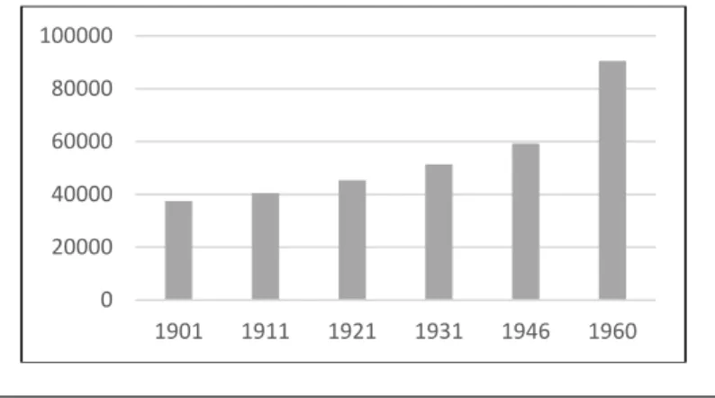
In 1940, the territory of Belize (around 5.7 million acres) was still sparsely populated with a total population of about 50,000 inhabitants, 40% of whom lived in Belize City (Fig. 2.2).
Fig. 2.2–Population of Belize, 1901-19604
century, the British deported them to Roatan Island in Honduras. They then settled on the continent in Belize, Guatemala and Nicaragua. Many of them currently live in the United States.
4 Compilation of official sources (Blue Book, Handbook, Census). Figures
slightly vary depending on the source and even within a single (official) publication. 0 20000 40000 60000 80000 100000 1901 1911 1921 1931 1946 1960
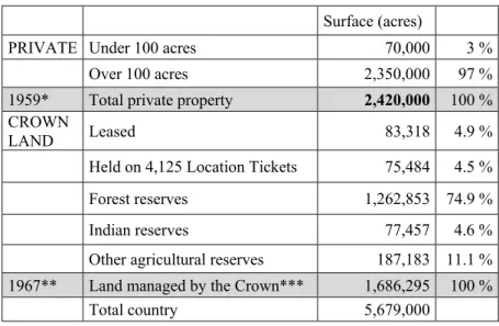
From the end of the 19th century, access to land was regulated by laws and orders that recognised the split of the colony’s land into private lands (slightly under 40 % of the total area) mostly to the north of the country, and Crown Lands in the south (Fig. 2.3). Fig. 2.3–Land distribution in Belize in the 1960s5
Surface (acres)
PRIVATE Under 100 acres 70,000 3 % Over 100 acres 2,350,000 97 % 1959* Total private property 2,420,000 100 % CROWN
LAND Leased 83,318 4.9 %
Held on 4,125 Location Tickets 75,484 4.5 % Forest reserves 1,262,853 74.9 % Indian reserves 77,457 4.6 % Other agricultural reserves 187,183 11.1 % 1967** Land managed by the Crown*** 1,686,295 100 %
Total country 5,679,000
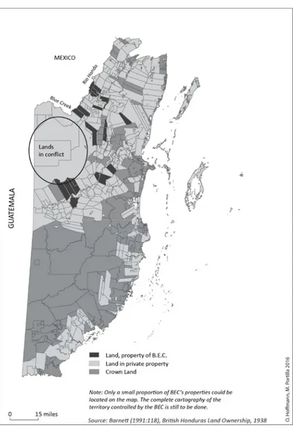
The map below (Fig. 2.4) roughly situates B.E.C. lands, locating the land portions that were disputed during the period 1940-1960 in the western part of the territory, bordering Guatemala. It also shows the division between private land and Crown Land in 1939 (Atlas of British Honduras, 1939, s/ed.).
5 Sources: *Wright et al. 1959, 270; **BARS, Survey Department, Annual
Report 1967; ***The total of the categories mentioned only corresponds to half of the total area of Crown Lands. The other half probably corresponds to the protected areas that were beginning to be created at the time (late 1960s) but also indicates a sub-register and/or multiple registration errors due to the sector’s fledgling institutionalization. Indeed, the 1967 Report indicates 3,347,878 acres for the total surface of Crown Land, which is almost the double of the other figure mentioned in the same report.
The history of the BEC goes back to the early 19th century with the first acquisitions of land by the settlers James Hyde, James Bartlett and John Hodge and the creation of the British Honduras Company in 1859. In the early days of colonization, land transactions were made according to the “Location Tickets” system that relies on individual agreements between settlers. The first institutionalization came with Superintendent Arthur’s initiative in 1817. The British Government assumed authority over the whole territory. It recognized settlers’ property rights to the land acquired before this date and declared all the remaining surface as “Crown Land”, namely property of the Crown. From this moment until 1872, all transactions were to be registered in a Deeds Registry that nonetheless remained rudimentary. As some contemporaries stressed:
From this date [1817] to 1872 grants of Crown land were regulated simply by instructions conveyed from time to time to the Superintendant, in despatches from the Home Government, and not by legislative enactment […] all grants and leases of land are now effected by the Governor issuing a ʻfiatʼ to the Keepers of Records, who then enter such grant, lease or license in their respective books, and the title is then complete (Bristowe and Wright 1888, 79).
By 1871, the company already played a central role in the colonial political sphere, since it contributed to the vote that established the Crown Colony, putting it under direct control of London instead of Jamaica as had been the case until then (Judd 1998, 133). The company became Belize Estate and Produce Company in 1875. In the 1920s, it drew its power from the fact that mahogany was one of the territory’s main resources, with trade tightly controlled by the authorities. In the 1930s, the BEC owned almost half of the private land in Belize and, crucially, controlled most of the work supply in the forest sector, which in turn dominated the colony’s labor market. The company was involved in a range of activities in diverse logging sectors (mahogany, logwood, chicle gum), processing (including a large sawmill), livestock farming, and other agricultural and commercial activities.
During the first half of the 20th century, the British Honduras economy still primarily relied on timber extraction, which had a strong impact on social practices and landscapes. This activity
followed a strict seasonal pattern. Cutting took place during the rainy season so that the trunks could be transported down waterways. The work teams (named gangs) were hired each year for the logging period and slept in transient camps close to the mahogany trees to be felled. The workers, mostly men, returned home (Belize City) during the dry season, and Christmas became a time of intense festivities in the towns. Few permanent villages were created inland. Farming was initially prohibited for most of the population, in particular slaves, and severely limited for the Mayan farmers that had been “invited” to gather in reserves. All efforts—and all available labor—had to be concentrated on logging. When slavery was abolished in the 1830s and for the same reason, i.e. the need to control the labor required for timber extraction, agriculture continued to be hugely hindered by land concentration that prevented free people and labourers from accessing farmland (Bolland and Shoman 1977). A small-scale farming sector did nevertheless survive in territorial gaps (i.e. between large properties, on their fringes or in very remote areas) and time gaps (i.e. between one felling season to the next), mostly without properly registered title deeds. There was therefore no “farming community” represented by institutions or spokespersons at the colonial, then national territorial level, but only local social groups that continued, despite everything, to undertake small-scale farming whose history is still little known, even refuted (Wilk 2006). The history of Yucateco Mayan farmers in the north, Creoles in the centre, Garifunas in the south, Toledo Mayas and others remains to be written.6
Around 1930, in a context of general recession that affected also the mahogany economy, the BEC needed liquid funds and attempted to sell its assets in Belize:
The Belize Estate and Produce Company survived the depression years because of its special connections in British Honduras and London. Since 1875 various members of the Hoare family had been principal directors and maintained a controlling interest in the company. Sir Samuel Hoare, a shareholder and former director, was
6 These experiences are starting to be recognised and studied by historians
and social movements calling for recognition of these specific small-farmer groups: Creoles (Hyde 2009), Garifunas (Palacio Carlson and Lumb 2011), and Toledo Mayas (Wilk and Chapin 1990) among others.
a former British cabinet member and a friend of Leo Amery, the British secretary of state for the colonies. In 1931, when the company was suffering from the aftereffects of the hurricane and the depression, family member Oliver V.G. Hoare contacted the Colonial Office to discuss the possibility of selling the company to buyers in the United States. (Merrill 1992, s/p).
At the same time, the company was also seeking credit. In both cases (sale and credit), it needed to regularise its property rights for lands it was exploiting in the west of the country at the Guatemalan border, some of them with no official title deeds. These comprised several portions of land spread out over a vast forested area that crossed no roads and included no stable villages. The company called on the British government to help resolve this double issue: to obtain official title deeds and/or get direct help in selling this land to US or British potential buyers.
However, the transaction project met with opposition and mistrust within the British establishment, which feared losing control over the land and, with it, control of the whole colonial territory and its people. The negotiations that ensued (1930-1950) illustrate the unease of economic and political elites faced with a situation that upset the relationships established between the various groups that had been involved in governing the territory and its spaces. The transfer of property would not only lead to a reorganisation of the alliances and hierarchies that had built up around the land issue; it would imply further, far-reaching, changes. In other words, what initially appeared to be a “simple” issue of transfer of land property was in fact enmeshed with local, colonial, imperial, and international politics.7 This situation was at the very heart of the land issue, which
7 On the basis of his analysis of Asian situations, Christian Lund has
identified close connections between property rights, citizenship registers, and institutions holding authority. These connections contribute to the constantly renewed production of the state (Lund 2016). Using a slightly different vocabulary, Jean-Pierre Chauveau points in the same direction (Chauveau 2017). He examines land and territorial dynamics, extending the issue of state authority and state formation to that of rural governance. To do so, he has developed the concept of “nexus”, namely the entwinement of land and political dynamics that contributes to reshaping the main fields of political action: state formation and competition over land control, migration
ought to be considered as an entire set of social relationships concerning the land, and not just as men and women’s relationships to the land (Colin, Le Meur and Léonard 2009). By modifying the content of their property rights (e.g. the object itself or rights of use), owners reorganise all of the components in the bundle of rights that constitute that property (Orsi 2013) and thus the very nature of social relationships associated with exercising those rights. Concerning BEC lands in Belize, the debate on property rights quickly became a major political issue because it both raised issues of sovereignty8 and
involved the control of strategic resources, in this case timber. The geostrategic factor was also significant: the mahogany-rich zones were located at the border with Guatemala, whose government refused to ratify the international demarcation line (Hoffmann 2014).
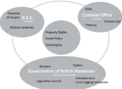
Starting in the early 1930s, the negotiations involved the colonial government, which could not remain impervious to local pressure, British government spheres in London, and the BEC, as shown below in the diagram (Fig. 2.5). Each individual hub was made up of multiple stakeholders that did not always agree with each other.
policies and conflict resolution. Chauveau’s theory is based on an “EFMC nexus” (Etat–state; Foncier–land; Migration and Conflict) that lies at the heart of contemporary rural governance dynamics.
8 On the relationship between property and sovereignty, and more generally
Fig. 2.5–Spheres and stakeholders in BEC negotiations, 1930-1950
In Belize, the colonial authority assumed by the local government represented by a governor and the Legislative Council also acted as a voice for local businessmen (traders and local logging companies), some of which were strongly concerned by the BEC’s local hegemony. The local colonial government also had to consider the opinion of the workers and inhabitants in general at a time of significant social unrest. Located partly in London and partly in the British Honduras, the BEC itself had to manage the interests of its owners and maintain its political networks while working on potential new alliances, in particular in the United States.9 Lastly, in
governmental spheres in London, the BEC affair was followed by Colonial Office specialists, in particular members of the Colonial Development Advisory Committee (CDAC, created in 1929) and
9 The BEC “was influential in the UK through its shareholders, and at least
officials of the Treasury and the Forest Policy Department.10 Even
just taking those who intervened directly and left a record in the archives, we can see the significant fragmentation identified by Georges Balandier in his work on the colonial situation:
Colonial society is not perfectly homogenous; it has its factions and its clans (the “administrators”, the “privates”, the “military men”, the “missionaries”, according to the wording used in French territories) that are more or less closed one to the other, or in competition (Administration-Mission and Administration-Trade oppositions are common) (Balandier 1951, 27, trad. A.-M. Harper).
In this multi-layered match, the BEC attempted—usually successfully—to impose political, economic and legislative measures that worked in its favour. It thus anticipated a major political shift, namely the end of British hegemony in this region. We may even say that it played a direct part in it, in so far as it focused on direct negotiations with US investors rather than British ones. In any case, the BEC had an important role in redefining property rights and the legality of land claims in the settlement.
Property Rights and Appropriation: Plural Norms
In the 1930s, during the great depression, the BEC’s political power in Belize was unstable. The company was facing growing discontent from its workers out in the forest camps and in the town. In Belize City, demonstrations and strikes showed resistance from workers and their families against the methods imposed by the BEC, including the “advance and truck system”, a payment method that10 This surveillance took place despite the fact that British Honduras was not
a priority for London. Overall, the budget for colonial affairs had been very tight for a long time. Although the Colonial Development Act of 1929 recommended carrying out development operations in the colonies, it was not until after the Second World War that the empire, already weakened, really put money into its colonies (Constantine 1984, 236). In 1924-25, the annual aid to the local colonial administration in British Honduras was one of the lowest, along with Dominica, Mauritius and Saint Helena (Ibid., 237). It increased during the 1930s with the funding of loans for infrastructures, several of which, as we shall see, were in fact destined for the BEC.
systematically put workers in debt and made them totally dependent on the company.11 Given this context, and finding itself in financial
difficulties following the 1929 crisis and plummeting international prices for mahogany and chicle, the BEC was keen to sell its assets, or part of them, especially those located in the west of the country, which were still rich in mahogany. An initial buyer (Bidwell) was rejected for lack of financial guarantees. The BEC then turned to the American company Mengel, which also owned land over the Mexican border (194,000 acres) where it had been exploiting chicle and mahogany since the early 20th century.12
At that point, a legal issue arose when the company recognised that it was not in possession of title deeds for most of its property. The lands in question were covered in forest sometimes dense with mahogany. They were adjacent to and in parts geographically overlapping with Crown Land. The BEC therefore entered into a double negotiation with the Crown. On the one side, the company asked the government to recognise its property rights, which it considered as acquired on some portions, even in the absence of official documents. On the other side, it asked to swap portions of BEC land that were distant from each other with Crown Land portions held by the government that were adjacent to its own. The exchange would allow both parties to assemble a vast, contiguous property.
The negotiation initially centred on the geographic characteristics of the lands, all of which posed problems, i.e. their extent (the areas were not precisely known, and until today there is no national cadastre that covers the whole country), quality (in this case the
11 This system was spread throughout the region and consisted in advancing
pay to the workers for the next wood-cutting season, and then discounting their expenses realized in the company’s stores. The workers would usually spend more than they were paid; they remained indebted to the company and bound to work with it, year after year. In that way, the company kept an economically captive labour force from one season to another.
12 On the Mexican side, the Rio Hondo lands, which came under the national
domain, were leased for set periods and objectives (chicle, mahogany). The largest plot was attributed to the Stanford Manufacturing Company in 1905 and covered 475,000 acres. In 1910, the biggest lessees were, in addition to the same Stanford Manufacturing Company: J.E. Plummer, Mengel y compañía, Banco de Londres y México (Chenaut 1989, 39).
supposed quantity of mahogany), location (international frontier zones were not clearly defined yet, despite a convention signed with Guatemala in 1860 mentioning “a straight line from the rapids of Gracias a Dios to Garbutts Fall”13), and legal status (absence of title
deeds). The arguments exchanged were accompanied by a considerable production of maps that were copied, proclaimed as lost then found again, sometimes contradictory, and sometimes unsigned and undated and therefore judged to be unreliable, which thus cast doubt among administrators in London (“if the map is wrong…” worried one civil servant in 193514). Before even mentioning a
cadastre or land register, the debate focused on the production of “land knowledge” that was inexistent in administrations at the time. The subject of the dispute was not the reality of the possession, but rather its terms and conditions.
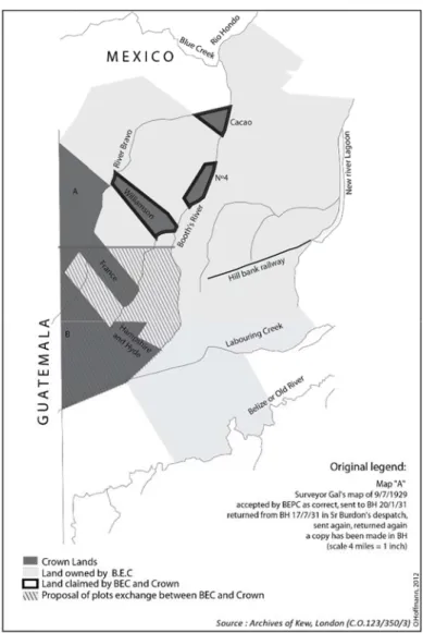
Following geographic identification, on the map, of the portions of land concerned by the future transaction, the company proposed exchanging certain Crown land parcels with some of its own land portions (Fig. 2.6). However, most of the latter had incomplete or imprecise deeds or no official title deeds at all. Their possession was claimed using arguments from different systems of legitimacy.
13 As shown in a 1867 map by Crown surveyor Faber (Hoffmann 2014, 50). 14 Colonial Office (C.O.) 123/350/3.
Fig. 2.6–Debated lands between Crown and BEC, 1919-193715
15 Map elaborated by Odile Hoffmann on the basis of original maps located
In some cases, when it was possible to formalise property rights, the company based its territorial legitimacy on formal legality by presenting a deed correctly registered with the territorial authorities of British Honduras; the property was thus guaranteed by the imperial-colonial institution and recognised by the social communities that it claimed to represent (the settlers and merchants). In other cases, the company claimed the same legal validity but could not provide written proof, alleging it had been lost or destroyed (plots “France” and “Williamson” on the map, Fig. 2.6). The company thus called on testimonies from neighbours, aiming to achieve a socially-recognised legitimacy and on the right derived from “quiet and undisturbed possession” of land according to the procedures established for this purpose in the law (Bolland and Shoman 1977, 72 and following). In a third type of case, the company did not claim to hold title deeds but instead asserted legitimate possession through its historic usage of the particular lands and the investments it had made there, e.g. a road or a section of railroad, or any other land improvement (plot “Hampshire and Hyde”, Fig. 2.6). The mejoras (“improvements”) argument was later extended to the notion of public good. The legitimacy of possession was supposed to be clear from the collective advantages that the so-called owner brought to the community. In the case of BEC this involved jobs and wealth brought by the timber business to the colonial society as a whole. The right of property would thus be “naturally” granted to the promoters of the colonial company due to its social function. Lastly, a fourth case occurred when the company recognised that it had neither deeds nor even arguments to establish its property rights on a plot, but instead proposed to regularise the situation by paying sums amounting to five years of overdue land taxes (plots “Cacao” and no. 4, Fig. 2.6). Without taking the list any further, we can see that the arguments combined standards that fall under very different types of legitimacy: “traditional” and “modern”, oral and written, local (linked to the territory) and global (derived from the colonial government). Such claims were supplemented with economic and political arguments in an entrenched set of rationales that reflect the power games between the parties involved (Colin, Le Meur and Léonard, 2010).
For eight years, negotiations on exchanging land parcels were carried out at the highest level between the directors of the BEC and the Secretary of State in London, sometimes in confidential letters that bypassed the colonial government in British Honduras and even the Colonial Office. They ultimately turned to the BEC’s advantage with the signature of an Agreement in 1937. This agreement endorsed almost all of the BEC’s demands, including the priority granting of concessions to exploit mahogany on Crown Lands. It definitively clarified land property rights in the western part of the colony, authorised the exchange of plots, thus opening the way for possible land-sale transactions on market conditions, as the company had sought.
The negotiators were aware of the explosive potential of flaunting treatment so clearly in favour of the BEC in British Honduras. Indeed, the BEC had a great deal of opponents within the colony: workers, as well as other traders and forest entrepreneurs, and the local colonial government itself, which had in fact expressed its resentment and attempted several times to prevent an agreement particularly favourable to the BEC. It even referred to the negotiations as a “farce”.16 It was nevertheless obliged to follow
orders from London and even had to pay land-surveying expenses established in the agreement (3,000 USD) despite the opposition of its Executive Council.17 The agreement was signed in London by
W. F. Gowers, acting as “Crown Agent for the Colonies” representing the British Honduras government, and the company directors18. This clarification of property rights made a sale possible.
16 “In such circumstances the settlement which has at least been arrived at
after long negotiation would be little more than a farce […] I am resolutely opposed to any proposal which would give the Company a privileged position” (6 March 1936, confidential from Governor British Honduras to S/S Colony).
17 C.O. 123/355/2.
18 “Between The Crown Agents for the Colonies acting for and on behalf of
the Government of British Honduras of the one part and the Belize Estate and Produce Company Limited of the other part” (C.O. 123/3615/2). In 1931 the BEC Board of Directors included Captain ERD Sir Samuel Hoare and his brothers Oliver Hoare and Richard Hoare, along with P.E. Whiting. In 1938 the Directors were: H. Barnett, Chairman; Edward O’Bryen Hoare,
The potential buyer was Mengel. Since it was a North American company, the Crown and the British Honduras colonial government had to agree to the transfer of property. Reservations focused on two major aspects, i.e. forest management and the empire’s territorial sovereignty.
Transfer of Property, Regulation, and Forest Policy
The controversy regarding the potential transfer of BEC properties to entrepreneurs less well known to the administration became part of a global debate on forest policy. This debate involved supporters and opponents to regulation in Great Britain and the broader British Empire at the time. The Colonial Office’s argument was quickly laid down: the government feared that, with the transfer of property, buyers would only be interested in overexploiting wood (mahogany) without making investments. It even mentioned “cliques of profiteers”, “destructive exploitation” and a “faction of traders” that should be treated with suspicion. The implication was that they were not “real” foresters, partners of the British government and its imperial forestry policy. The government had considerable experience of negotiating with the BEC and feared losing its capacity to intervene with new owners.The call for regulation also seemed to prevail on site in Belize. The local government claimed to fear that a foreign company with a considerable, even disproportionate, territorial and financial footing would totally eradicate all forest management policies.19 Supported
by its local Executive Council, the government suggested conditioning the issue of title deeds on exploitation that ensured the renewal of logged trees and the protection of saplings. It would grant a “title in fee simple” (full and unconditional private ownership) ten years after having authorised cutting on a given portion of land provided that the beneficiary—here the BEC or its buyers—had not
O.V.G. Hoare; P.E. Whiting, Managing Director; Alfred Sawyer, Secretary (C.O. 123/374/5).
19 “Acquiescence by the Government would be a negation of its forest policy
and would stultify the maintenance of a forest organisation”, wrote Oliphant, a Forestry Conservator in British Honduras in 1930 (C.O. 123/331/4, 1929-30).
overexploited the forest and had not felled mahogany trees (or cedars) with a girth of under 90 inches.20 It also took on the views of
forest technicians, who produced a major report in 1942 in which they recommended regulating cutting, in particular of mahogany.21
However, the report dismissed any idea of intervention and, in the case of the BEC, suggested leaving the company to manage its relations with sub-contractors.22
In addition to measures to prohibit or restrict the extraction of forest resources, the regulation policy recommended by the authorities claimed to intervene on what would later be called land-use management, in particular through land taxes. The local colonial government insisted on the fact that an efficient land tax would bring resources to the territory and at the same time act as an instrument to control wood cutting and land management. This was all the more strategic given that the international status of territorial boundaries was not stable yet, as we shall see in the following section. Yet when in 1931 the colonial administration attempted to increase land tax, the BEC and other major forest owners simply refused to pay (Petch 1986, 1007).
By the end of the 1930s, the anti-regulation clan appeared to be gaining ground, and in 1941, the Colonial Office aligned itself with the arguments put forward by the BEC itself (its directors Samuel Hoare and P.E. Whiting), with a totally free-market logic of self-regulation: according to them, interventionism was not indispensable in terms of forest policy because a strictly economic attitude was sufficient to prevent over-cutting of the forests. In their opinion, the mahogany market did not drive over-cutting and, in any case, the scant available labour would prevent it from happening.23
20 C.O. 123/335/6, 1931-1932. 21 C.O. 123/382/7.
22 “Any arrangements with the contractors might well be left to the
Company to make in the ordinary way of business” (Robertson report, 19-2-1942, C.O. 123/382/7).
23 “The attitude of the American company in not wishing to spoil property
for which they were paying a considerable sum of money […] economic considerations alone would prevent over-cutting […] there was no market for very much larger supplies of mahogany. […] with a seasonal trade and the limited labour force of British Honduras, no very serious over-cutting could take place”. Letter of 29 July 1941 (folio 22) marked “secret” from the
The sale of BEC land finally took place in 1942. The buyer (with 90 % of the shares) was a British citizen, Albert Gliksten, one of the directors of Gliksten Investment and Property Trust Limited, a British company he owned jointly with his brother Stanley. Gliksten, who was born in 1898, had experience in the processing and trading of timber and was familiar with British Honduras since he had lived there for eighteen months.24 He was enthusiastic about his new
acquisition and moved with his wife to Belize, where he set to modernising the company and making new experiments (e.g. tests to process and industrialise lemongrass, modernisation of animal rearing, exploitation of secondary timber after felling large mahogany trees). He was in step with the imperial forestry policy. The balance between the BEC (now owned by Gliksten25), the
British Honduras government and the authorities in London was however upset when Albert Gliksten suddenly died in 1952. His brother Stanley, who took over from him, did not continue to invest in Belize and sold off his assets in several operations, marking the end of the BEC’s forest hegemony in Belize.
Transfer of Property and National Sovereignty:
The Colony’s Role in the Empire
The potential sale of a major British company to North American investors (as Bidwell and Mengel, for instance) raised the issue of sovereignty. For London, the arrival of a new (American) owner of the BEC would mark a break in the organic connection between the Empire, its territory, and the company, and see the latter two move a step closer to the United States26. In addition, it would feed into an
Colonial Office to J. Hunter, Governor of British Honduras (C.O. 123/382/6).
24 Letter of 19 January 1942 from Whiting to C.O. (C.O. 123/382/7). 25 “Mr Oliver Hoare called to see the Secretary of State last week and
explained that the BEC is now controlled by Mr Albert Gliksten, a Director of Gliksten Investment and Property Trust Limited, who has acquired 90 % of the shares. The sale has been completed.” (January 20th, 1942, C.O. 123/382/6)
26 “The BEC would sever their connection with the Colony, thus completing
Americanisation phenomenon that was already well under way, as Governor Alan Burns pointed out when he declared in 1935 that the people in the colony were “more American than British”.27 These
sovereignty issues entailed geopolitical and economic factors, as well as domestic policy.
The first problem was the fear of seeing a foreigner at the heart of the border conflict with Guatemala. Border control was a constant cause of concern for Great Britain. As a reminder, territorial boundaries had only been established at the end of the 19th century with Mexico (Tratado Spencer-Mariscal in 1893) and were still not determined with Guatemala. Here as elsewhere, along with military control, border control involved a policy of settling and occupying land. In a country as scantly populated as late 19th century British Honduras, the colonial authorities had imagined a policy of “Indian reserves”, one of whose aims was to stabilise populations in frontier zones (Wainwright 2003; Hoffmann 2015). Half a century later, the issue had not been solved and was still relevant in the 1940s. If the BEC were to sell its border lands to an American, the territorial disputes with the Guatemalan neighbour would hold no more secrets for the new owner, which might take advantage of the situation to the detriment of the Colony and its reputation.28
The same argument was put forward, but this time to underline the sale’s positive potential for the economic development of the country. Relations between Belize (and Great Britain) and Guatemala were so bad—as Guatemala still did not accept the frontier’s definition despite the 1860 Convention—that it seemed impossible to imagine that a British company might ever pursue an economic project involving both sides of the border. The Americans could be better placed to negotiate with Guatemala the opening of a railway in the Guatemalan forest regions of Peten, for example. In other words, the economic interests of the British territory would be better defended by American entrepreneurs. However, this argument was immediately refuted by A. Burns, Governor of British Honduras from 1934 to 1939 and Assistant Under-Secretary of State for the
27 Quoted by Assad Shoman 2009, 80.
28 “There is also a disagreable and discutible (discreditable) boundary
dispute which a foreign holder might exploit with disastrous results to the credit of the colony” (letter dated 10 December 1931, C.O. 123/335/6).
Colonies at the time of his writing. He pointed out that the Guatemalan President Ubico (1931-1944) was strongly opposed to any communication project between Belize and Guatemala, whether involving the British or the Americans.29 This opposition was in fact
confirmed several months later by a letter from the British Legation in Guatemala (J. H. Leche) to the Foreign Office in London on the same topic.30
Yet sovereignty was not just a geopolitical affair. Reticence to see the company transferred to North American interests was worsened by Great Britain’s apprehension at losing control of the strategic resource that mahogany represented for British industry. The sale of the BEC to an American firm would mark the end of Great Britain’s self-sufficiency in quality mahogany timber. At that time, wood was used in the aviation industry on a global market that was almost exclusively controlled by six North American companies. In the eyes of opponents to the sale, the Americans’ objective in purchasing the BEC would be to reorganise the global mahogany market, either by eliminating a potential competitor through buying the company and stopping all activity in Belize, or by consolidating their monopoly. In both cases, Great Britain would lose its independence.31 However, once again, nothing was stable,
and a report commissioned several years later by the British government tempered and even contradicted this interpretation. The report reveals that the Americans did not wait for the sale of the BEC to make headway and rapidly dominate the local timber market. According to this report dating from 1943, along with the BEC three American companies were operating in the colony.32 They were
29 C.O. 123/382/6, 1941.
30 Ubico cancelled the Puerto Barrios-Belize flight route (two flights a
week), even though aeroplanes owned by Aerovías de Guatemala (whose main shareholder was the president’s wife) flew over the British territory every day to transport chicle extracted in Peten to the port of Puerto Barrios for export. Protests by the Foreign Office received no reply (21 May 1942, C.O. 123/382/7).
31 “In any case, it appears undesirable as a matter of long-term policy that
the supplies of aircraft mahogany should be entirely in their [i.e. American] hands.” (C.O. 123/379/4, 1940).
32 The Weis-Fricker Mahogany Company, the I.T. Williams & Company
supplied by local contractors who obtained their permits to cut down mahogany from the British Honduras government as independent entrepreneurs but were in fact financed by big companies. The three American companies even provided the British Ministry of Supply with mahogany for aviation.33
Financial transactions between the BEC and American interests were not new. Back in 1938, the BEC had signed agreements with the American company Wrigley for the production of chicle. In 1943, in the midst of Second World War, the buyer of BEC, Gliksten, went to the United States to discuss with the Board of Economic Warfare possibilities of selling off his wood in the United States. This negotiation did not particularly shock civil servants working at the Colonial Office in London. For some of them at least, the issue of sovereignty was not necessarily at the forefront in handling the colony’s future. They rather saw the colonial government’s role as watching over the country’s economic development by protecting the interests of local entrepreneurs and traders in the face of the greed of major timber companies, whether British or American.34
Up to the end of the 1920s, the BEC, thanks to its control of the forests and its strong presence in the west of the Colony, appeared to be the main agent of British sovereignty in the region. In the 1930-40s, changing modes of land appropriation led to perturbations in three main domains: in the geopolitical field, the fact that the new owners were not so close to the British government as were the previous Board directors could lead to British loss of control of the land bordering Guatemala; at the geostrategic level, British industry would lose its autonomous supply of mahogany; and in domestic policy, the colony’s development began to depend on new actors. After the Second World War, authorities in London appeared to be
The latter’s mahogany production was the same as that of the BEC in 1941 (6 million square feet).
33 This ministry previously dealt with the BEC but was not satisfied and
preferred to trade with the Americans. It is also worth remembering that the US was Britain’s vital ally during the Second World War.
34 “I think it is the duty of the British Honduras Government to protect the
local timber interests as far as possible from being squeezed out by big business interests whether British or American” (R.H. Burt, 5th of June 1943, C.O. 123/382/7).
more preoccupied with economic profitability than with defending British supremacy in British Honduras. A territorial vision of sovereignty made way for political pragmatism.35 The threatening
“other” no longer took the shape of North American rivals, but came from inside, when forest workers and a disgruntled population began undermining the colony.
In the early 1930s, three major phenomena contributed to shake the colonial order: the 1929 Great Depression, the decline of the mahogany economy, and the terrible 1931 hurricane that destroyed a large part of the installations in Belize City. These events led to extreme poverty against which people rebelled with demonstrations and riots. In 1934, the first strike against the BEC took place in Belize City’s sawmill, with A. Soberanis at its head. The movement was organised by the Labor and Unemployed Association (LUA), a Labour Union that sowed the bases of what became the People’s Committee, then the People’s United Party (PUP). This party headed the social struggle for independence and achieved its main goal with the Declaration of Self-Government in 1964. In some way, it can be said that the 1930s mark the emergence of modern politics in Belize (Bulmer-Thomas 2012) with the increasing organization of labour and the beginning of a democratic discussion.
Conclusion
The decade of the 1940s in Belize saw the final chapter of an imperial model of forest governance (Barton 2001). Ultimately, British hegemony was undermined by American interests without any transfer of property rights between citizens from either country. This hegemony took the form of control over mahogany trade circuits and maritime transportation, namely the financial and
35 Eric Léonard, upon reading the first version of this text, pointed out that it
would be interesting to establish the chronology of arguments regarding international relations during the same period between Great Britain, the United States, and Nazi Germany and its potential allies. The choices were not the same at the height of the Great Depression, in a context of protectionism, and during the Second World War, when Great Britain was closely dependent on US aid. It may be no accident that everything started moving in 1942-1943, just as the United States formally joined the conflict.
technical devices structuring the market. Land and wood property certainly remained strategic, but more to ensure the advantages of a British oligarchy vis-à-vis its own government than to defend the interests of the country vis-à-vis the exterior. On the international scene, Great Britain no longer occupied the dominant place from which it had built its empire up to the 1920s.
The governance of resources may have involved a co-production of the colonial space between actors located in London (Colonial Office, Treasury Office, Ministry of Supply), Belize (Governor, Legislative Council, traders, BEC) and on the ground (inhabitants, workers). However, the interplay of alliances was never stable. The Colonial Office sometimes appeared to be in a dominant position and at other times dependent on BEC directors. In the external sphere, the Americans and the British were either political rivals but economic allies, or political allies but economic rivals.
This case study illustrates the way colonial space was constructed and disputed at the same time, and not only imposed from above. By “colonial space” we mean firstly a political space, i.e. a space of daily internal interactions between local actors, which also involved broader connections with the United States and Central America. This political space only existed because of the strategic resource at its core, which during decades was the forest resource. The ecological space (forest land) was indeed inherently political (Escobar 2008). A third kind of space was involved in the production of colonial space. It is the cartographical or cadastral space that organised and legitimised space occupation, as we can see with the maps produced by the BEC and other British colonial actors to claim land property rights in British Honduras (Hoffmann 2014)36. These
three kinds of space together constitute what geographers have conceived as “spatial technologies” to describe territorial practices used by the British Empire in other colonial territories such as Malaya (Malhi 2011) or Vancouver (Rossiter 2007).
Despite this great diversity of situations and strategies, one thing remained constant: the extreme arrogance of the BEC and its directors’ conviction that they were in possession of a pre-eminence
36 I thank Didier Guignard and Iris Seri-Hersch for suggesting the
that was sufficient to justify all their demands.37 This would be an
example of what Rossiter, in his study of Vancouver Island, calls an imperial geographical discourse (Rossiter 2007). Vancouver Island was a British colonial territory that had similarities with British Honduras. It was also a forested territory presented as an “empty” or almost empty settlement.38 It became a colony in 1858 with no treaty
or consideration for native populations and was subject to disinterest from London in terms of local administrative affairs. The forest landholders reigned as masters, just as they did in British Honduras. In this respect, Rossiter (2007) argues that a “geography of possession” was embedded in imperial culture and disseminated as a set of discourses that may be qualified as “imperial geographical imaginations”. In a highly moralistic vision, these imaginations differentiated civilised areas from wild ones; the former were the fruit of colonisation settled by white people and exploited for their timber resources; the latter were inhabited by native and neglected people. Only the civilised areas—both lands and individuals that exploited them—deserved having rights.39 Just as the supremacy of
the colonising, white nation was “presented as rooted [fondée] in history and nature” (Balandier 1951, 25), land possession in a colonial context was put forward as being legitimate in itself. This perception permeated all social, economic and political life. Before the Second World War, land appropriation in British Honduras was at the centre of a nexus woven around relations to established power, imperial forestry policy and issues of territorial and economic sovereignty (on the notion of nexus, see Chauveau 2017). It was this
37 As witnessed by this disillusioned comment from one of the BEC
directors, Samuel Hoare, concluding one of his numerous petitions: “It is not a controversy between capital and labour, stagnation and progress, it is a controversy between a small community, mostly of money lenders and rum sellers, and the representatives of the only real resources that the Colony possesses.” (C.O. 123/333/12- 1930-1931)
38 Similarly to the Mexican forest land that neighboured British Honduras in
the southern Yucatan whose colonisation has been studied by Macías and Aarón (ed.) 2004, Villalobos 2005.
39 “The institution of forestry in the colony relied upon a conception of
property rights that turned on the identification of civilized and savage space, holding that only particular kinds of labour and land improvement warranted claims of ownership” (Rossiter 2007, 770).
“knot” between the above-mentioned fields that changed after the war. Change did not affect one field more than the other, or one after the other, but rather one field through the other. This process ultimately led to the overall transformation of social hierarchies and the challenging of the colonial situation.
Bibliography
Atlas of British Honduras. 1939. s/ed.
Balandier, Georges. 1951. “La situation coloniale. Approche théorique.” Cahiers internationaux de sociologie, vol. 11: 44-79. Barton, Gregory. 2001. “Empire Forestry and the Origins of
Environmentalism.” Journal of Historical Geography 27, no. 4: 529-552.
Bristowe, Lindsay W., and Philipp B. Wright. 1888. The Handbook
of British Honduras for 1888-89, comprising Historical, Statistical and General Information concerning the Colony.
Edinburgh and London: William Blackwood & Sons.
Bolland, Nigel. 2004 (first edition in 1988). Colonialism and
Resistance in Belize: Essays in Historical Sociology. Belize City:
Cubola.
——— and Assad Shoman. 1977. Land in Belize, 1765-1871. Kingston: University of the West Indies.
Bulmer-Thomas, Victor. 2012. The Economic History of the
Caribbean since the Napoleonic Wars. Cambridge: Cambridge
University Press.
Chauveau, Jean-Pierre. 2017. “Le nexus État, foncier, migrations, conflits comme champ social.” Critique Internationale, no. 75 (April-June): 9-19.
Chenaut, Victoria. 1989. Migrantes y aventureros en la frontera sur. Mexico City: SEP-CIESAS.
Colin, Jean Philippe, Pierre-Yves Le Meur and Eric Léonard (eds.). 2009. Les politiques d'enregistrement des droits fonciers. Du
cadre légal aux pratiques locales. Paris : Karthala-IRD.
Constantine, Stephen. 1984. The Making of British Colonial
Development Policy, 1914-1940. London: Frank Cass.
Escobar, Arturo. 2008. Territories of Difference. Place, Movements,
Life, Redes. Durham: Duke University Press.
Hoffmann, Odile. 2014. British Honduras: The Invention of a
Colonial Territory. Mapping and Spatial Knowledge in the 19th Century. Belize: Cubola-IRD.
———. 2015. “Políticas territoriales y exclusiones étnicas en Belice: un siglo de transformaciones en tierras maya.” Revista de
Estudos e Pesquisas sobre as Américas, Universidad de
Hyde, Ritamae Louise. 2009. “Stoan Baas” People: En
Ethnohistorical Study of the Gales Point Manatee Community of Belize, MA History and Archeology, UWI-Mona Campus.
Jacob, Jean-Pierre and Pierre-Yves Le Meur. 2010. Citoyenneté
locale, foncier, appartenance et reconnaissance dans les sociétés du Sud, Paris: Karthala.
Judd, Karen. 1998. “In the Name of the People: Populist Ideology and Expatriate Power in Belize.” In The White Minority in the
Caribbean, edited by Howard Johnson and Karl S. Watson,
133-158. Kingston: Oxford, Princeton: Ian Randle Publishers, James Currey Publisher and Markus Wiene Publisher.
Lund, Christian. 2016. “Rule and Rupture: State Formation through the Production of Property and Citizenship.” Development and
Change 47, no. 6: 1199-1228.
Macías Zapata, and Gabriel Aarón (eds.). 2004. El vacío imaginario.
Geopolítica de la ocupación territorial en el Caribe oriental.
México: CIESAS.
Malhi, Amrita. 2011. “Making Spaces, Making Subjects: Land, Enclosure and Islam in Colonial Malaya.” The Journal of
Peasant Studies 38, no. 4: 727-746.
Merrill, Tim (ed.). 1992. Belize: A Country Study. Washington: GPO for the Library of Congress, 1992.
http://countrystudies.us/belize.
Moore, Sally. 1973. “Law and Social Change: The Semi-Autonomous Social Field as an Appropriate Subject of Study.”
Law & Society Review 7, no 4: 719-746.
Orsi, Fabienne. 2013. “Elinor Ostrom et les faisceaux de droits: l’ouverture d’un nouvel espace pour penser la propriété commune.” Revue de la régulation, no. 14 (Autumn). http://regulation.revues.org/10471.
Palacio, Joseph, Carlson Tuttle and Judith R. Lumb. 2011. Garifuna
Continuity in Land: Barranco settlement and Land Use 1862 to 2000. Caye Caulker, Belize: Producciones de la Hamaca.
Petch, Trevor. 1986. “Dependency, Land and Oranges in Belize.”
TWQ 8, no. 3 (July): 1002-1019.
Powell, Joe M. 2007. “‘Dominion over Palm and Pine’: The British Empire Forestry Conferences, 1920-1947.” Journal of Historical
Rossiter, David A. 2007. “Lessons in Possession: Colonial Resource Geographies in Practice on Vancouver Island, 1859-1865.”
Journal of Historical Geography, no. 3: 770-790.
Shoman, Assad. 2009. Historia de Belice. El surgimiento de una
nación centroamericana. México: UNAM-CIALC.
Sutherland, Anne. 1998. The Making of Belize: Globalization in the
Margins. Westport, CT: Bergin and Garvey.
Toussaint Ribot, Mónica. 1993. Belice: una historia olvidada, México: Instituto Mora-CEMCA.
Villalobos, Martha. 2005. El bosque sitiado. Asaltos armados,
concesiones forestales y estrategias de resistencia durante la guerra de castas. México: Ciesas-Porrua-Inah.
Wainwright, Joel. 2003. Decolonizing Development: Colonialism,
Mayanism, and Agriculture in Belize. University of Minnesota:
PhD thesis.
Wilk, Richard. 2006. Home Cooking in the Global Village: Belizean
Food from Buccaneers to Ecotourists. Belize City: The Angelus
Press, London: Berg Publishers.
——— and Mac Chapin. 1990. “Ethnic Minorities in Belize: Mopan, Kekchi and Garifuna.” SPEA Reports, no. 1: s/p.
Wright, A. C. S., D. Romney, R. Arbuckle and V. Vial. 1959. Land
in British Honduras: Report of the British Honduras Land Use Survey Team. London: Colonial Research Publications 24.