HAL Id: halshs-00410669
https://halshs.archives-ouvertes.fr/halshs-00410669v2
Submitted on 16 Oct 2009
HAL is a multi-disciplinary open access
archive for the deposit and dissemination of
sci-entific research documents, whether they are
pub-lished or not. The documents may come from
teaching and research institutions in France or
L’archive ouverte pluridisciplinaire HAL, est
destinée au dépôt et à la diffusion de documents
scientifiques de niveau recherche, publiés ou non,
émanant des établissements d’enseignement et de
recherche français ou étrangers, des laboratoires
Claude Grasland
To cite this version:
Claude Grasland. SPATIAL ANALYSIS OF SOCIAL FACTS: A tentative theoretical framework
de-rived from Tobler’s first law of geography and Blau’s multilevel structural theory of society. Handbook
of Quantitative and Theoretical GeographyorAdvances in Quantitative and Theoretical Geography,
Faculty of the Geosciences and Environment of the University of Lausanne, pp.000-046, 2010.
�halshs-00410669v2�
SPATIAL ANALYSIS OF SOCIAL FACTS
A tentative theoretical framework
derived from Tobler’s first law of geography and Blau’s multilevel structural theory of society
C. GRASLAND
Université Paris Diderot UMR 8504 Géographie-cités
This document presents an attempt to build a theoretical framework for the spatial analysis of social facts, derived from Tobler’s first law of geography (‘Everything is related to everything else, but near things are more related than distant things’) and Blau’s theory of macro sociology and multilevel structural analysis. At individual level four basic times of position and interaction are defined (geographical/sociological and discrete/continuous). It is then necessary to discuss the effects of scale aggregation and time dynamics on the elementary levels of position and interaction. This part is illustrated by examples about airflows between world cities in 2000 and euro coins diffusion across borders between 2002 and 2007.
KEYWORDS
Theory, Social Science, Geography, Sociology, Spatial Analysis, Social Morphology, Durkheim, Simmel, Blau, Tobler.
INTRODUCTION
In friendly tribute to Waldo Tobler and in memory of Peter M. Blau (1918-2002)
This document presents an attempt to build a theoretical framework for the spatial analysis of social facts, derived from Tobler’s first law of geography (‘Everything is related to everything else, but near things are more related than distant things’) and Blau’s theory of macro sociology and multilevel structural analysis. Waldo Tobler’s first law of geography is defined by “everything is related to everything else, but near things
are more related than distant things” [88]. This law was formulated in 1969 and many authors claims it is not still valid in a global world where distance in general - and physical distance in particular - are less and less important for the understanding of economic, political and social dynamics. Following Tobler, I argue that focusing on a “space of flows” rather than a “space of places” as it is proposed by many authors in their research on Global City [2,72,19] does not mean that physical distance has to be excluded from spatial interaction models, on the contrary. Moreover, I proposed to demonstrate that the distinction between “places” and “flows” is a kind of nonsense if we adopt the perspective that distance is not independent from flows.
The Association of American geographers has recently precisely organized a special session on Tobler’s first law in 2001 and published the results in AAAG in 2004, with six contributions [1, 32, 50, 54, 79, 83] and a reply of Waldo Tobler himself [87]. Some of the authors are critical and consider Tobler’s first law is nothing more than “unlawful relation and verbal inflation” [79] and can be explained by a specific step in the history of sciences [1]. Other authors are very positive but do not really discuss the law and use rather it as a justification of their own scientific activity of geographers, for example in the field of Geographical Information System [32] or Physical Geography [54]. But only two authors [50, 83] examine how Tobler’s first law could be used as a way to build bridges between Geography and other Social Sciences, in particular sociology.
Based on my previous research, in particular [34], I propose to demonstrate here that Tobler’s first law provides the theoretical basis for a specific research field called spatial analysis of social facts, which could be located at the border between Geography and Sociology. As noticed by many specialist of human geography [68, 43], spatial analysis was for too long confined to the study of objects and paid insufficient attention to the behavior of individuals and groups. The study of the spatial behavior of individuals and groups is a subject that has been largely overlooked in the other social sciences, though it is the very core of the specific contribution that geography could potentially make to the social sciences generally : ‘Social
science deals with behavior and good theory is about behavior. Since all behavior occur in spatial contexts, what then distinguishes the work of human geographers from that of social scientists more generally? […] As all geographers know -though, curiously, many refuse to acknowledge- the spatial arrangement of things usually affect behaviors. The core of spatial analysis to the behavioral geographers is the analysis of behavior in its spatial context’ [68].
In the first section of this chapter, I present firstly an analysis of Tobler’s first law of geography in connection with other works published by Tobler at the same period of his career, in particular the inversion of gravity model that make possible to link positions, distances and interactions. I demonstrate that the inversion of gravity model modify completely the point of view on gravity model as distance can be an output rather than an input of the analysis. What is important in gravity model is not its capacity to predict flows but its capacity to link structures and interactions. As a personal complement to Tobler, I develop the importance of barriers that are related to discrete attribute of spatial position (e.g. belonging to a political unit) and can be sometimes more relevant for explanation that quantitative attributes related to continuous attributes of location like coordinates.
In the second section, I present Blau’s macro sociological theory of social structure that is a theoretical attempt to link social positions and social interactions through the concept of distances and opportunities. The formal analogy between the approach of Blau and Tobler make possible to derive a generalized framework of analysis of social facts, at the border of Geography and Sociology. I demonstrate how the axioms and theorems proposed by Blau for the analysis of social integration can be easily transposed to geographical parameters of position that can be either quantitative (distance) or qualitative (belonging) and are formally equivalent to the distinction made by Blau between graduate social parameters (e.g. income) and nominal social parameters (e.g. religion).
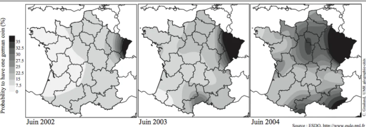
In the third section, I focus on my personal contribution about the elaboration of a theoretical framework for the analysis of social facts that integrate the previous discoveries made by Blau and Tobler in a wider perspective. I examine in particular the difficulties to combine parameter of social and geographical position in the same explanatory model and I discuss how the analysis of a particular situation as to be integrated in a wider perspective in terms of scales of aggregation (emergence, determination) and time dynamics (memory, anticipation). These theoretical considerations are illustrated by recent research results on the diffusion of euro coins in Europe, which is considered as a proxy of global mobility. This example proves that the proposed theoretical framework can be applied on concrete situations and that both sociological and geographical factors can be nicely combined in the explanation of international mobility.
FROM TOBLER’S FIRST LAW TO GRAVITY MODELS AND THEIR INVERSE
Tobler’s first law of geography
Looking at the contributions published by AAAG on Tobler’s first law of geography, I was very surprised to observe that most contributor’s focused on the famous isolated sentence (“Everything is connected to everything, but near things are more related to each other than distant things”) without exploring its relations with the article where it was published, the article published at the same time period and the following works
of Tobler. It is not so surprising if we consider that, out of some very famous paper like “Push Pull migrations lows” [24] or “Geographical filters and their inverse” 86], many publication of Tobler are difficult to read as they was unpublished preliminary version or purely grey literature. When I organized a seminar on Tobler’s work with C. Cauvin in 2002, it was very difficult to realize a complete compilation of his paper and the 4 volumes that we was able to summarized did finally not cover all his bibliography. Invited to this seminar, Waldo Tobler could fill some of our gaps in its bibliography but not all. And we were finally very surprised that such an initiative of collecting the complete works of Waldo Tobler has not been engaged in the USA before we did it in France.
Tobler’s first law was published in the paper entitled “A computer Movie Simulating Urban Growth in the Detroit Region” in the review of Economic Geography in 1970. In this relatively short paper of 7 pages, the main concern is the elaboration of a model of population forecast by computer simulation, which is a very near from actual cellular automat procedures and other dynamic model like SIMPOP 71. The first law of geography appears in its complete form only at the third page but the first part (“everything is related to everything”) is formulated much earlier in the second paragraph of the introduction, with a clear position in favor of a positivist and structural approach of social life: “As a premise, I make the assumption that everything is related to everything else. Superficially considered this would suggest a model of infinite complexity; a corollary inference is that social systems are difficult because they contain many variables; numerous people confuse the number of variable with the degree of complexity. Because of closure, however, models with infinite numbers of variable are in fact sometimes more tractable than models with a finite but large number of variables” 88. Tobler clearly consider that a scientific approach implies to write simple models able to capture a large part of the reality, rather than trying to cover every dimension. Moreover, the simplest models are the most general and are therefore likely to be transposed from one field of research to another. About his model, Tobler comments: “The model recognizes that people die, are born and migrate. It does not explain why people die, are born and migrate. Some would insist that I should incorporate more behavioral notions (…). My attitude, rather, is that since I have not explained birth, death or migration, the model might apply to any phenomenon which has these characteristics, e.g. people, plants, animal, machines (which are built, moved, destroyed), or ideas. The level of generality seems inversely related to the specificity of the model” 88.
My own practice of Tobler’s work has led me to the personal feeling that the key of Tobler’s first law cannot be found in this paper which is rather a claim in favor of scientific geography but not really a demonstration of the law, at least for the second part (near things are more related to each other than distant things). It is rather in two other papers published at the same period that we can find a clearer demonstration of the interest of a symmetric approach of positions and interactions through distance, which is for me the major contribution of Tobler to theoretical geography. To support my assumption that linking position and process is the core of Tobler’s contribution and the key of interpretation of its first law, it is important to remind also that the paper Geographical Filter and their Inverses was published in 1969, one year before the first law, and focused precisely on the theoretical problem of discovering processes through the analysis of forms: ‘If one assumes that geographical processes operate at various scales, then a filtering by scales could separate processes. The Fourier interpretation of scale is the wavelength, or, equivalently, the form of the spread function. Large-scale processes can thus be separated from small-scale processes as a preliminary step in geographical analyses. Some examples follow’86]. This was really a research program that was defined here and the publications of the following years were therefore clear attempts to propose empirical validations in various fields.
In the paper published in 1970 and entitled “Geobotanical Distance between New Zealand and Neighboring Islands” 89], Tobler presents for the first time an empirical application of the inversion of gravity model and demonstrate how it is possible to derive positions from interactions and how, more generally, it is possible to link the analysis of flows and dissimilarities. In this work realized with natural scientists, Tobler appears has first author (against alphabetic order) and this fact demonstrates clearly that he realized the core of the demonstration. Briefly said, the paper demonstrate how it is possible to propose a simulation model of diffusion of Botanic species between the islands of new Zealand and to estimate what was the effect of distance on this diffusion. Even if we ignore the initial location of species, it is possible to make assumption on it through an inversion of gravity model. Of course, the model does not fit very well with reality as it is based on Euclidean distance, but further complexity can be added and anyway it is sufficient to demonstrate
that near things are more related to each other than distant things. Contrary to the common opinion, Tobler does not believe that the concept of distance can be reduced to its basic geometrical component. But he claims that the simplest model should be firstly applied before to propose more sophistical versions based on residuals. This is very clear in this paper where the authors write: “Model-building is useful not only because it may allow predictions but also because it identifies areas for further research by making assumptions explicit (…) Although the existing model cannot explain all distributions, one-third of the floristic variation between New Zealand and neighboring islands is explained by island location and size alone, demonstrating the importance of spatial arrangement in plant geography”.
One year later, in 1971, Tobler published with S. Wineburg in Nature what we consider as his most fascinating realization. Entitled “A Cappadocian Speculation” [90], this very short paper proceeded to a secondary analysis of archeological data and tried to determine the location and the name of unknown cities mentioned on the cuneiform tablets found by Hrozny near the village of Kültepe in 1925. The author notice immediately in the introduction that “This is theoretical geography in the sense of Bunge, which is conditional on several assumptions.” Contrary to previous researchers that had tried to analyze the relation between cities mentioned on the tablets through historical approach or linguistic approach, Tobler focus immediately on geographical distances that he proposes to estimate through an inversion of the gravity model assumption: ‘On a purely random basis, one would expect the names of large towns to occur more
frequently than the names of small towns. The total expectation is thus that the interaction between places depends on the size of the places and the separation between the places. This rather obvious result has been verified in a large number of societies and for many phenomena. Specifically, we expect the interaction to increase as the places get bigger, and to decrease as they are farther apart. Many functions satisfy such a requirement. For social interaction the most common formulation is the so-called gravity model:
Iij = k Pi Pj / d2ij
Where Iij is the interaction between places i and j; k is a constant depending on the phenomena; P, is the population of i; P is the population of j; and d is the distance between places i and j ‘[90]. Of course, we
ignore what is the size of the cities and the flows between them, but we can propose an estimation of these variables: the size of cities is estimated by the frequency of quotations on the tablets and the flows are derived from the common citation of names. It is now possible to extract the distance by transforming the previous equation in:
dij = (k. Pi Pj / Iij)1/2
But distance is only an intermediate step of the research as the real goal is to link the names of the unknown cities mentioned in the tablets with archeological spots that was discovered in the region. To fulfill this objective, Tobler proposed to use a trilateration method in order to derive the positions of cities from their distance and to produce a map of hypothetical position as some name of cities were known and related to precise locations in space. The final result was the famous map presented in Figure 1.
One more time, Tobler use Euclidean distance as basic reference of the analysis but he claims that it is not an obligation and that the model proposed here could be extended to different situations: “Distance may be
in hours, dollars, or kilometers; populations may be in income, numbers of people, numbers of telephones and so on; and the interaction may be in numbers of letters exchanged, number of marriages, similarity of artifacts or cultural traits and so on” [90].
In our opinion, the most important discovery of Tobler in 1970-71 is not the efficiency of the gravity model (it was established before), neither the importance of simplicity in scientific model (it was a very common thought in this period). The crucial discovery of Tobler is the fact that positions and interactions can be analyzed in a symmetrical way through the concepts of movements and accessibility. From this point of view, the common distinction proposed by M. Castells 19 and followers [2, 23, 72, 85] between the so-called ‘space of places’ and ‘space of flows’ is a kind of nonsense. What does really matter is to define what are the relevant geometries for a common description of both positions and interactions. A real criticism of Tobler rely probably more on the choice of his favorite geometry (Euclidean, continuous) than in the ignorance of the importance of flows. But we have seen that Tobler’s always claim that they are no reason to limit the analysis of relations between flows and structure to the case of Euclidean distance. From this point of view, Tobler’s idea are fully compatible with the network society and we have no reason to reject Tobler’s first law on the basis of more and more complex forms of accessibility taking the form of network. As an example derived from my presentation at the ECTQG 2007, we can compare the position of main airports according to Euclidean distance and to airflows distance (derived from an inverse gravity model).
Figure 2 : Predicted positions of 100 world cities according to euclidean distance and air flows in 2000.
What I want to illustrate with this two figures is the fact that the interesting scientific question is not to produce an artificial opposition between places and flows but, on the contrary, to propose various representations of places according to various types of flows by means of various types of distances. The map of Euclidean distances between cities is interesting for a given set of flows that are related to physical proximity. For example, the explosion of a nuclear plant power like Chernobyl has much to do with Euclidean distance, even if winds can introduce some anisotropy. If a nuclear problem appears in Toronto, we will obviously use the map (a) based on Euclidean distance to estimate the danger for neighboring cities and consider that Chicago is more likely to be concerned than Paris. But if we are interested in the propagation of a disease by means of air flows, it is certainly more relevant to use a distance based on the frequency of air flows as the one presented on map (b). In this map, the distances are derived directly from the flows through the inverse of a double constraint model. The proximity of cities reveals here the existence of small worlds of interconnected cities that are more connected than expected according to a random network [42]. We are exactly in the situation of the “Cappadocian Speculation” but the tablets has been replaced by the number of flights between airport and are something like what could be analyzed by an archeologist of the future making assumption on the location of cities according to the discovery of a manuscript describing air connections in 2000.
The justification of spatial and territorial interaction models in a social sciences perspective
Starting from Tobler’s perspective of joint analysis of positions and flows, the status of the gravity model appears completely different as it is no more a deterministic model but a tool for the analysis of society that can be analyzed both in classical and inverse forms. To precise this point, it is firstly necessary to remind some basic evidences on the theoretical justification of the decrease of interactions with distance and to complete what Tobler consider as obvious in his publications. At this point, we will introduce a more personal touch by considering not only continuous measure of distance (measured in time, kilometer, cost, energy) but also discrete forms of distance related to common belonging to a geographical area. In our publications and academic teaching courses, we propose to use the term “spatial interaction” for general effects of distance measured in a mathematical continuous form and to specify “territorial interaction” when we want to measure the discontinuous effect of a partition of space.
One remarkably persistent misconception is the claim that applying Newton’s law of universal gravitation to human movement is the main justification for the use of spatial interaction models. While it is undeniable that it has played a major part in their historical development, from Ravenstein and Reilly to Stewart and Zipf, the analogy should serve primarily as the starting-point rather than the end point of any theoretical inquiry into the role of geographical positions in the development of relations between individuals or groups. This is hardly the place for a comprehensive historical survey of the various stages in the development of models of social interaction. Still, it is worth noting that, in parallel with the refinement of instruments of formalization and modelization of flows at a macroscopic level, several theoretical currents have sought to provide an account of the concrete actions and processes that determine the spatial mobility at the level of individuals or small groups and which explain the emergence of regulations at the higher aggregate level constituted by places. At the same time, the empirical applications carried out at different levels and in different territorial or institutional contexts have tended to make more complex the basic hypotheses of the gravitational model and to refine it significantly with the addition of other variables besides the simple effect of Euclidean distance (linguistic barriers, political borders, infrastructure networks, time or cost of relation, etc.).
In my view, there are three broad categories of hypotheses that are liable to provide the theoretical foundation for models of spatial interaction (effect of distance) and models of territorial interaction (effect of belonging to the same grid). The following outline of these categories will be based on the specific case of migrations.
Justification by the economic theory
relation and the cost of moving. Irrespective of the specific kind of cost incurred (monetary, psychological, temporal), the migrant is assumed to be a rational being seeking to optimize the relation between the benefits provided by mobility and the cost of mobility. If the opportunities of mobility situated at different points in space offer the same benefits for the migrant, she will merely seek to minimize the function of use constituted by the cost of moving. In theory, every migrant ought therefore to choose the destination involving the lowest cost, i.e. the closest destination. But because the migrant is in competition with other agents, there is an imbalance between offer and demand of mobility for some destinations. Because of such competition, he/she may therefore have to opt for a destination that involves a higher cost or to abandon all hope of moving if the cost involved is higher than the predicted benefits. The regulation between offer and demand should produce a balance resulting in a decrease of the probability of a relation according to the cost of moving. Formalized thus, the economic explanation does not prejudice the nature of the cost of moving and its relation to the geographical situation of individuals. An additional hypothesis is therefore required to change the economic determinant (the cost of moving) into a geographical determinant.
In the case of models of spatial interaction, I submit the hypothesis that the costs of moving borne by the migrant are proportional to a given distance that is presumed to include a range of pressures bearing on the decision of mobility. Thus, in the case of a change of address, the choice of a remote destination implies a monetary cost (the cost of moving), a psychological cost (the rupture of social relations with individuals in the original location), a relational cost (the time involved in moving from the original location to the destination, if the migrant decides to make periodic returns), etc. Most of the distances that determine the overall cost of relation are variously correlated with Euclidean distance, which is the main justification for the efficiency of predictions obtained by means of the gravitational models, even the simplest ones.
The same hypotheses are equally applicable to a model of territorial interaction where the cost is dependent not on the number of kilometers effectively covered but on clearing limits of territorial grids. This is especially apparent in the case of trade flows where crossing a political border entails tax payments (monetary cost) and a waiting period that may vary at the border in question (temporal cost). But the same principle applies to the mobility of individuals. A person moving to another area or country is often forced to carry out a number of administrative formalities that entail a range of costs (temporal, physical, and financial), not to mention the psychological cost if the territorial grid in question is a particular territory or an inhabited space to which the individual is particularly attached.
My empirical research on internal migration in multinational countries (Belgium, Czechoslovakia, and Cameroon) demonstrated many times that territorial interaction effects are sometimes complementary to spatial interaction effects 14. And in any case, they should both introduce simultaneously in the model in order to control their relative contribution to explanation. Barriers are not residual of gravity models based on distance but alternative forms of analysis of reality that implies the existence of discontinuities in social and spatial organizations.
Justification by means of the theory of information flow
The economic account of geographical interaction is all the more relevant since it does not reduce the notions of cost and utility to a mere monetary equivalence and since it also includes in its definition other factors such as time, attractiveness, habit, etc. A number of recent studies in spatial economics have tried to formalize subjective distances by showing that they are the product of a learning process and that they are thereby subject to more or less important intervals in relation to the distances that a homo economicus needs to consider.
Hägerstrand’s theory of the field of spatial information usefully complements the economic account by focusing on the information received by or made available to agents that is relevant to their opportunities of destination. The traditional economic paradigm presupposes that every agent is a rational and well-informed being, and assumes that an agent is fully aware of the cost and benefits of every relation that she is liable to forge. In practice the paradigm remains unverified. Any material flow is accompanied and preceded by counter-flows of information that enable agents to make a rational choice between several destinations
though in a context of limited information.
Hägerstrand’s central hypothesis is that the probability of material relation between two individuals or groups depends on the quantity of information circulating between these individuals or groups. For example, the theory helps to provide an account of the process of self-maintenance of long-distance migratory channels. The settlement of the first migrants generates a flow of information between the point of origin and the destination, which facilitates the arrival of new migrants, who in turn will generate a still greater flow of information, and so on.
In the case of models of spatial interaction, it is the hypothesis of a deterioration of information in relation to the given distance that helps to account for the decrease of probabilities of relation as a result of distance. An individual seeking to change address is far better informed about their migratory opportunities in their immediate environment than they would be in a distant environment. Within their immediate environment, they may benefit from local relays (parents, friends, newspapers, classified advertisements...) that facilitate their decision. In a more distant environment, they will incur a variety of costs in order to acquire information about their destination. Faced with two equivalent opportunities (such as two jobs with the same income), the agent will often choose the closer option because more information will be available and a number of uncertainties will presumably be removed, thus enabling the agent to act with full knowledge of the facts.
To a certain extent Hägerstrand’s theory of information flow accounts for the decrease of probabilities of relations with distance. But it applies just as much (if not still more so) to models of territorial interaction. Indeed, Hägerstrand [44, 45] was the first to articulate the notion of a barrier that prevents the propagation of innovations and information flow. Obstacles to relations, whether physical (mountain range, lakes, rivers), political (borders, administrative limits) or social (linguistic barriers, socio-cultural discontinuities), often result in a decrease of information exchanges between inhabitants located on either side of such barriers. The effects of such barriers on information flow are numerous. Examples of barriers that prevent the complete circulation of messages between two territorial entities include super-absorbing barriers, which destroy the message and the sender, absorbing barriers, which merely destroy the message, and reflexive barriers, which return the message to its point of origin without destroying it. Cases of hermetic barrier are comparatively rare. Permeable barriers that allow for a transmission of some of the messages according to their permeability are far more frequent.
In short, the effect of barriers is both the concentration of information within territorial grids and the correlative weakness of information exchanges between territorial grids. In practice, this means that at an equal distance, an agent will have at their disposal more information pertaining to the opportunities of relation with the inhabitants of their own territorial grid than with those located in different territorial grids. The agent will therefore tend to privilege such relations, even if a higher cost is thereby incurred. Furthermore, if a territorial limit is an obstacle to the acquisition of information (for example as a result of linguistic barriers), the migrant will devote more energy to the acquisition of information related to opportunities of mobility in their new environment. The economic paradigm and the paradigm of information flow thus tend to complement and strengthen one another in the justification of the hypothesis pertaining to models of territorial interaction.
Justification by the sociological theory of interposed or grouped opportunities
Among the many criticisms leveled at the application of models of spatial interaction to the study of social relations, one of the most significant objections concerns the nature of the distance used to describe probabilities of relations. Most models of spatial interaction use a continuous measure of distance designed
to reflect the impact of the cost of moving on the decision to develop a relation. The use of a function of decline of the probability of relation is the same for all the inhabitants or, at the very least, there is an average behavior that describes mobility continuously in relation to distance.
However, the hypothesis is only valid if the opportunities for relations are distributed evenly in space, i.e. if every agent has at their disposal an equal number of short, medium and long-range relations. This is not generally the case, which means that individuals situated in areas offering a low potential for relations are often forced either to incur greater costs or to reduce their mobility. Nevertheless, it is obvious that when mobility constitutes a response to a minimum need for relations, it is the first solution rather than the second that will tend to be adopted.
The solution provided by the sociologist S. Stouffer [80, 81] in order to bypass this difficulty is to alter the role of distance and to use it merely as an ordinal criterion allowing an agent to classify opportunities for relations. Generally speaking, the agent classifies their potential destinations in relation to the benefit/cost ratio, and then examines them sequentially. The probability of forging a long-distance relation does not therefore depend on the absolute value of this distance but on the number of opportunities in a more immediate environment. As the number of interposed opportunities (situated at closer range) increases, the possibility that the migrant will already have obtained satisfaction and decided against examining distant opportunities becomes ever more probable.
Stouffer’s solution is illustrated by the example provided in Figure 3. Two individuals situated at points A and B purchase their bread in either one of two bakeries situated in 1 and 2. If we were to apply gravitational logic strictly, we would have to say that the individual located at point B has a greater probability of using bakery 1 than the individual located at point A, because she is located twice as close to the bakery. But the individual located at point B has at her disposal a closer opportunity for a relation and if she decides to minimize the cost of moving, she will opt for bakery 2. By contrast, the individual located at point A has no alternative at her disposal; bakery 1 is the closest bakery to her house (no interposed opportunities). Unless she chooses not to eat bread, she will therefore agree to incur a higher cost of moving. Thus, contrary to predictions made on the gravitational model, the person situated at point A is more likely to use bakery 1 than the person located at point B, if the two agents adopt a strategy that aims to minimize distance. In fact, if ordinal distance is used instead of direct distance (ranks of opportunities), the behavior of the agents is in keeping with the logic of the spatial interaction model.
Figure 3 : The case of the two bakeries
Thus Stouffer’s model helps to improve models of spatial interaction and to make them more realistic by demystifying the role of distance. The decrease of probabilities of relation as a result of distance does not necessarily correspond to a mechanical effect but may be interpreted by means of a psychological hypothesis of behavior. Indeed, Stouffer’s critique mainly pertains to gravitational modeling (simple constraint of preservation of all the flows) but it does not target the double-constraint models of the kind devised by Wilson or Tobler. The latter incorporate competition for destinations, thus helping to predict
situations of the kind illustrated in Figure 3. Indeed, if we assume that every inhabitant uses a single bakery and that every bakery has just one customer (a double constraint of preservation of the total flows that are emitted and received), the most likely situation from the point of view of the minimization of mobility costs is that resident A uses bakery 1 and resident B bakery 2.
Stouffer’s model therefore validates the hypotheses of spatial interaction models and undermines the objection that they project mechanistic models onto the spatial behavior of individuals. However, what remains to be shown is the validity of the hypothesis of the agents’ behavior that underlies Stouffer’s theory. Models of spatial interaction posit that agents organize opportunities of relation according to distance, which is presumed to reflect the cost of forging relations. This amounts to having recourse to the economic paradigm, which we previously demonstrated was equally applicable to models of territorial interaction. It also amounts to assuming that the agent is fully informed of the entire range of opportunities of relation and that her classification takes account of the full range of relevant information.
However, as we saw previously with Hägerstrand’s model, the agent need not necessarily have at her disposal the exhaustive range of relevant information, and so the organization of opportunities that serves as a basis for her choice may be founded on partial or incomplete information. All other things being equal in relation to distance, the agent may have the use of more complete information related to the opportunities for relations situated within her own territorial grid than information pertaining to the opportunities for relations in different territorial grids. The agent’s classification may therefore be a function not merely of distance but also of territorial affiliation, which may cause her to adopt a behavior that is both spatial and territorial. The migrant may also deliberately choose to prioritize territorial affiliation as a criterion of choice of destination. It is thus possible to conceive of forms of embedded classification in which a migrant decides (1) to migrate if possible within their affiliation grid and (2) to opt for the closest destination, all other things being equal in relation to affiliation.
In the example of the two bakeries, it is conceivable that it is children who purchase the bread and that their parents are keen for them not to have to cross any roads. The decision rule established by the parents is thus an embedded choice that consists (1) in crossing as few roads as possible (territorial effect) and (2) in choosing the nearest bakery, all other things being equal in terms of the number of streets which have to be crossed (spatial effect). In this case, the inhabitants of residence B will choose bakery 1, which, despite being further, has the advantage of being located in the same block of houses (territorial grid) and does not entail having to cross a street (territorial limit). For the inhabitants of residence A, whoever purchases the bread will have to cross at least one street, and it may even be necessary to go to bakery 2, since the inhabitants of residence B, who are nearer, will more readily make use of the opportunities (bread loaves) located in bakery 1.
Other studies, particularly those by A.S. Fotheringham 30] have sought to enrich Stouffer’s theory of intermediary opportunities with the concept of grouped opportunities. The models of spatial interaction based on the impact of masses and distance do not always take account of the spatial autocorrelation of such masses, i.e. the fact that there are areas at a higher level than the grid under study in which opportunities are either grouped or dispersed. Yet the migrant moving to a distant destination does not merely take account of the opportunities on offer at the destination but also considers those that she will be able to reach around the destination at the cost of a limited displacement. The consideration of groups of opportunities therefore presupposes an alteration of the basic hypotheses pertaining to the two-dimensional (rather than one-dimensional) character of geographical space. The most promising solution seems to reside in the elaboration of embedded models that study interactions between locations at different aggregate levels, thus allowing for the inclusion of concentrations of opportunities for relations at different levels.
The statuses of the theoretical hypotheses upon which the models of geographical interaction are based extend well beyond the fact of a simple analogy with Newtonian physics. And it seems difficult to overlook, at least as a hypothesis, how they might influence the constitution of social networks at different levels. In conclusion, I would insist on the fact that the division of spatial analysis between analysis of location and analysis of interaction is certainly useful for pedagogical reasons (I follow generally the division proposed in the two volumes of the manual published by Pumain & Saint-Julien 58, 59 for teaching at license degree) but it can be also an obstacle for deep understanding of linkage between positions, distances and
interactions (I try generally to introduce an integrated approach at the level of master degree).
LINKING TOBLER’S FIRST LAW OF GEOGRAPHY WITH BLAUS’S MULTILEVEL STRUCTURAL ANALYSIS
The paradigm of multilevel structural analysis and macro sociological theory of social structure elaborated by the American sociologist P.M. Blau (1918-2002) provides in our opinion a useful theoretical framework for the analysis of the impact of territorial grids and of geographical proximities more generally on the constitution of relations or networks at different levels of social reality [7,10,11]. While it can hardly be said to overlook the individual determinants of social interaction, Blau’s work focuses more specifically on effects of structure and context, i.e. the mid-level analysis of social forms of association or integration [46,74]. To this extent, Blau’s perspective is an extension of Durkheim’s work on social integration and social morphology but introduces also Simmel’s ideas on crosscutting circle. Although Blau does not explicitly envisage the role of the geographical proximity of individuals as a factor of social integration[29, 53], given some readjustments his theory and its central concepts are sufficiently broad to be applicable not only to the study of the impact of sociological positions but also to the study of geographical positions.
Blau’s work is therefore especially pertinent in the present context because it is based on a distinction between quantitative and qualitative variables of sociological positions, which is analogous to the distinction used in my own work between distance and barrier effects 34 for the description of geographical positions or interactions. This study will therefore presently examine how Blau’s theory might be extended by considering, in addition to the two kinds of position commonly used by sociologists, two other positions aimed at describing the geographical properties of the location of individuals or groups that interact within a given society.
The present analysis refers mostly to a synthesizing article of 1993 10. This paper is one of the last publications of Blau (at the age of 75) and can be considered as a summary of the part of its work devoted to structural analysis of society. It is more or less equivalent to Chapter 1 of his final book published in 1994 11. We refer also to earlier paper where Blau elaborated the first version of a macro sociological theory of social structure 6, 7.
Four elementary types of geographical and sociological positions
Blau’s structural analysis begins by defining a multidimensional space by way of describing the social position of individuals according to a range of properties known as structural parameters. According to 10 , structural parameters belong to either one of two elementary kinds that may combine to form more complex combinations.
(1) Nominal parameters pertain to the qualitative attributes of individuals and define social categories such as ethnic group, religious affiliation, professional activity, etc. The degree of differentiation of nominal positions is a reflection of the heterogeneity defined by Blau in the simplest sense of the term as the probability that two members of a given population belong to different groups.
(2) Graduate parameters refer to quantitative attributes, i.e. continuous distributions of differences of resources and statuses such as income, education, etc. that serve to define social strata. The degree of differentiation of graduate parameters reflects inequality, defined at its most basic as the coefficient of variation (or Gini index) of differences between levels.
Applied to the study of geographical positions, Blau’s distinction overlaps with the distinction made in my own work and discussed in the previous section between territorial parameters and spatial parameters of location.
(3) Territorial parameters pertain to qualitative variables of the location of individuals such as their affiliation with different territorial grids, which operate an exhaustive partition of space and society. Every individual belongs to one or several territorial grid; the status of these parameters is formally equivalent to the status of the nominal parameters defined by Blau. In its paper of 1977 on ‘Macro sociological theory’ Blau include ‘places’ as a particular case of nominal parameter and proposes some specific theorems related to the effect of place location and distance. But he does not consider as useful to distinguish this parameter of other categorical variables like sex or religion, even if it recognizes that they produce specific effects on social integration and organization of heterogeneity and inequalities.
(4) Spatial parameters refer to quantitative variables of location such as a system of coordinates including latitude (X) and longitude (Y). This two-dimensional space may be characterized by a metrics with the usual properties of mathematical distance (identity, symmetry, triangular inequality). Note the significant difference with Blau’s level variables; insofar as spatial parameters commonly operate in pairs (a system of coordinates with a metrics) and, in most cases, they are not oriented. Admittedly there may be cases where the spatial configuration of positions is one-dimensional (such as location on a highway or on a hill) or oriented (distance from the town-center). But these are particular situations and the more general case, which the remainder of this study will examine, is the two-dimensional space characterized by a Euclidean metrics devoid of any particular orientation. It is also important to notice that some geographical distances cannot be directly derived from system of coordinates by metrics and are related to network organization (e.g. accessibility by road in time). But it is not necessary, in our opinion, to introduce a third category for this situation as it can be considered as a network location that can produces quantitative measure of distances (time, cost…) that is the formal property of interest here. We have also seen in previous section that, following Tobler’s first law of geography, we can reverse the gravity model and transpose network distances into metrics by multidimensional scaling (eventually with some lose of information).
Figure 4 : Four types of sociological and geographical position with areas of uncertainty
MATHEMATICAL PROPERTIES NOMINAL / QUALITATIVE
(-> Heterogeneity) Area of uncertainty
GRADUATE / QUANTITATIVE (-> Inequality) SO C IET AL PR OPE R T IES SOCIOLOGICAL POSITIONS
(-> Social distances) Social category
(ex. religion)
(ex. Cast, social
class or professional category) Social level (ex. income) Area of uncertainty
(ex. nationality) (ex. ethnical Group) (ex. distance from a center)
GEOGRAPHICAL POSITIONS
(-> Geographical
distances) Territorial location
(ex. administrative units)
(ex. position in
urban network) Spatial location
(ex. latitude, longitude)
Parameters of sociological position will be used to refer to the attributes of individuals that are theoretically independent of their location at the earth’s surface or that are not at the very least directly altered in the short term by the movement of an individual in space. By contrast, parameters of geographical position refer to the attributes of individuals that serve to describe their present location at the earth’s surface and that undergo complete or partial modifications every time an individual moves. The distinction is not a straightforward one and will require further refinements in due course with the more explicit consideration of
the time scales that underlie the suggested definition. Indeed, the past geographical position of an individual (such as their birthplace) is often liable to become a parameter of sociological position, i.e. a lasting attribute of an individual (ethnic identity, nationality). But this particular point would require a more extensive account well beyond the limits of the present study.
The four types of positions thus defined primarily constitute a formal conceptual framework capable of clarifying a whole range of models and hypotheses. But they only define a partial schema (what, for instance, of economic or historical positions) containing many areas of uncertainty (Figure 4). While a number of attributes may be easily assigned to one of the four categories of propositions outlined above, other attributes are more difficult to assign unambiguously. A whole range of categorical (qualitative) sociological variables refers implicitly or explicitly to a hierarchy (casts, social or professional categories) and may also be interpreted as level variables. Similarly, in geography, the notion of neighborhood may refer either to a common affiliation with the same territorial grid (a person living in the same neighborhood or commune) or to a criterion of geometrical proximity or temporary accessibility (a person living less than 5 km or 10 minutes away). The distinction between sociological and geographical positions is no clearer. Thus, nationality tends towards the realm of sociology (an attribute that is independent of spatial location) in the case of rights of kinship, while it will tend to function as a geographical concept in the case of territorial rights. The distance from a symbolic place of social life (church, monument, sanctuary, town center) often relates to both types of sociological and geographical categories. Note also that ethnic identity may be viewed as implying all these categories, which it incorporates to varying degrees... An excellent discussion of the danger of fuzzy ethnic categories as compared to objective census categories (like administrative province of birth) is presented in the analysis of the role of the political capital Yaoundé in the building of Cameroon state by 12. A comparative analysis of internal migration an regional integration in multi-national states (Belgium, Cameroon, Czechoslovakia) 13,14 reveals also how it is difficult to isolate the respective effects of physical distance, administrative borders, linguistic regions and inherited historical divisions. Though imperfect, the four provisional categories outlined above may help to refine and widen the content of Blau’s theory. The focus will now turn to the principal axioms, theorems and corollaries of the theory and to an examination of the implications of the theory for the study of sociological and geographical positions.
Positions, distances and reductions of relation opportunities
The fundamental hypothesis of Blau’s structural theory is that positions constitute structures that have a weak determining effect on the relations forged by individuals 10. This weak determinism implies that the structure in question may not necessarily exert a direct pressure on individual choices (by ruling out certain relations or making others compulsory), but exerts rather an indirect pressure based on the restriction of opportunities for relations resulting from differences of position and the correlative increase of sociological or geographical ‘distances’ between individuals [36]. This point is crucial for the connection we propose to establish with Tobler’s first law of geography. As Tobler, Blau is not directly interested in the analysis of structures but on the analysis of the relation between structures and interaction through the intermediate but crucial concepts of distances and opportunities. Therefore they are not subject to the classical criticism of structuralism as they do not try to explain structure by structure but try rather to link macroscopic emerging social and geographical organization with interactions that take place between social units at local level 16, 22. But it does not mean that this approach refers only to individual determinations, on the contrary. The precise nature of the psychological or sociological mechanisms determining this restriction of opportunities for relations between geographically or sociologically ‘distant’ individuals varies greatly: internalization of norms, lack of information, preferences, material or immaterial cost, budget-time restriction, etc. But such mechanisms do not strictly speaking constitute the object of structural analysis, which focuses less on the individual determinants of relations than their aggregated result. The object therefore is to examine how the structure of positions (distance(s) between the full range of individuals or groups that constitute a society) determines the structure of interactions (relation(s) between individuals or groups constituting a given society) according to a specifically probabilistic approach.
However, the primary focus of Blau’s structural theory is not to isolate the impact of a specific position (a specific distance), but rather to study the global consequences of the compatibility or incompatibility of the various positions that individuals occupy simultaneously. Therefore the primary focus of his analysis is the internal structure of the multidimensional space of positions. Blau formulates the hypothesis that the internal structure to a certain extent determines tendencies for integration or anomie within a given society. His theory is thus situated in a direct line of descent from both Durkheim’s social morphology 27, 28 and Simmel’s geometry of social life 76, 77, 78. Simmel draws a distinction between societies founded on concentric social circles where the affiliations of individuals are based on successive inclusions within ever-widening groups, and societies founded on crosscutting social circles in which individuals participate simultaneously in different categories of affiliation that do not include the same members. For Simmel, the former case corresponds to traditional societies, whereas the latter is characteristic of modern societies displaying a high degree of social complexity.
Note that Simmel’s distinction concerning social circles is directly applicable to the case of territorial grids. The administrative divisions within a given state may thus abide by a strict interlocking, with each grid containing a finite number of N-1 grids corresponding to Simmel’s concentric social circles. But it may also be the case that the state uses specific grids for every control issue or for every problem that it has to resolve. In this case, there is no embeddings but rather a partial overlapping between different grids.
Nonetheless Blau’s primary focus are crosscutting social circles because they are more frequent in the societies which he studies, notably the large American metropolis in which individuals tend to belong simultaneously to ethnic, religious or professional groups defining systems of positions that operate more or less independently of one another and which seldom overlap 8,73. Still his theory is just as applicable to concentric social circles, which Blau analyzes indirectly through his study of the percolation of heterogeneity within the various organizational strata of social life. The theory is based on two propositions that may be viewed as axioms and that constitute the premise for a series of theorems [7, 10, 11]:
Axiom 1: the probability of a relation between two individual depends on the number of
opportunities for contact between them.
Axiom 2: the proximity of two individuals within the multidimensional space of social positions
increases the number of opportunities for contact.
From the point of view of a geographer, the two axioms clearly define a system of models of individual interaction in which the hypotheses correspond exactly to the gravity models of spatial interaction used in geography at a more global level. Models of spatial interaction may be viewed as an aggregated articulation of Blau’s theory in the specific case where the position of an individual is described solely in terms of their spatial location. The number of relations between two locations is proportional to the product of their respective populations (a consequence of axiom 1 at the level of population aggregates); the intensity of relations between two locations decreases in accordance with the distance that separates them (reduction of axiom 2 to the case of the geographical position of the individuals constituting the population aggregates). Not necessary to add that this two axioms are more or less equivalent to Tobler’s first law of geography as the axiom 1 implies that ‘everybody individual is related to every individual’ with more or less opportunities and axiom 2 can be written as ‘near individuals are more related than distant individuals’.
Blau’s first theorem
The first theorem inferred by Blau from his two basic axioms is that the probability of inter-group relations is a direct function of the heterogeneity of the population in question. On the face of it, the first theorem has very little use given that it merely appears to articulate the notion that the macroscopic diversity of a given population has an impact on the diversity of relations potentially forged between the members of the population. However, the underlying idea is that the processes of segregation that may disrupt the development of relations between individual members of different groups are even less likely to appear as social groups are numerous and of similar size. The idea also rests on the assumption that individuals wish
to have a minimal number of opportunities of forging relations to make their choice and that, when they are unable to find a satisfactory number of such opportunities within their own group, they are more willing to consider opportunities for relations with other groups. More generally, the value given to an opportunity for a relation is presumably not a parameter that operates independently of the social context in which relations are forged. What this implies is that the microscopic rule for the evaluation of opportunities for relations between groups depends in some cases on the macroscopic structure of the society in question and of the geographical context of the locations where such relations are forged.
Blau’s first theorem pertaining to the impact of qualitative position variables is directly applicable to the domain of political geography, where it has often been used to describe the impact of the number and population of administrative units composing a given state. As the number of constitutive elements of a state increases and remains of roughly equal size, so the degree of autonomy of the latter is potentially reduced in relation to central power. The disintegration of the administrative grid multiplies the opportunities for relations between two individuals located in different territorial grids and reduces in the same proportions the probability that social relations are structured or concentrated within the same territorial unit. Therefore it reduces in theory the risk of one of the territorial grids being erected into an autonomous political entity liable to oppose the power of the central state and to claim its independence as explained by C. Raffestin 62 and empirically validated by M.C. Maurel 47,48,49 and V. Rey 63,64 in the case of socialist countries. More generally, the multiplication of territorial grids increases the relative weight of relations that may be subject to the control of central power (such as a declaration of change of address). The degree of territorial fragmentation, defined as the probability that two inhabitants are located in different territorial grids, is thus formally equivalent to the social heterogeneity defined by Blau concerning categorical variables. In the context of a political theory of the kind devised by Ratzel 62, this degree of territorial fragmentation operates as a measure of global territorial integration, which measures the degree of coalescence of territorial segments and is equivalent to the social integration defined by Durkheim as the degree of coalescence of social segments [27,28].
Blau’s second theorem
Blau’s second theorem states that the development of inequalities within a given population increases the probability of relations between partners at different levels. An ostensibly paradoxical suggestion, the theorem is based on the same observation as the first theorem, namely that the diversity of social levels (a quantitative attribute) implies an excessive restriction of opportunities for relations if partners choose only to foster relations with individuals at a similar level. However, Blau’s theory [7, 10, 11] is incomplete because it does not examine the highly diverse forms of social inequality, particularly in view of the existence of discontinuities in the distribution of social levels (Figure 5).
Figure 5 : Three theoretical situations of distribution of social levels according to a given criterion (income, education, etc.)
According to this theorem, a society that includes two moderately different middle classes (situation B) is less unfair but probably far more closed than a society consisting of a continuum of individuals at different levels (situation A). In situation B, every individual will have many opportunities for relations with individuals at the same level, whereas in situation A an individual will need to develop relations with other individuals at different levels if she is to have a sufficient number of opportunities. However, Blau’s argument is not altogether convincing since we might easily conceive of a situation C in which levels are highly differentiated (variation coefficient comparable to the variation coefficient of situation A) but where there are discontinuities in terms of distribution (as in situation B). Differences of level may not therefore necessarily result in an increase of relations between partners at different levels. The result is a situation that is comparable to situation B if the number of opportunities is adequate in every group separated by discontinuities of the higher and lower groups. It would appear therefore that Blau’s second theorem applies specifically to unimodal strata distributions and is more debatable in the case of multimodal distributions. The theorem is still worth applying at a social level. Note also that the more a given population is concentrated in space around a limited number of poles, the more likely it is that long-distance relations will be forged between the inhabitants of this space.
By analogy with the situation of the various strata described above, in situation A the probability of two spatially-distant individuals actually meeting is probably smaller than in situation B. In the first case, every individual situated at a given location will have enough opportunities if they gradually widen their circle of spatial relations. With the exception of individuals in marginal positions (within the space under study), the rule describing the average distance of contact is isotropic. In the second case, every individual is located within the field of a common density gradient that incites them to move to the point of maximum density by way of finding the maximum number of opportunities for relations. The spatial structure therefore potentially favors relations between distant individuals who may nonetheless be subject to a common field of attraction (the town-centre in the case of a town). The most challenging case to interpret is Situation C because the existence of multiple cores provides a large number of opportunities for close-range contacts. On the other hand, individuals who wish to have a number of opportunities higher than the size of the population core of which they are a member are forced to establish relations at a greater distance than in the two previous cases because of the presence of interstitial voids (discontinuities). The result is a situation where there are strong analogies between the theories articulated in geography pertaining to the organization of urban networks (‘Rhenan’ and ‘Parisian’ models) and the distinction drawn in sociology by Granovetter 36 between strong ties that create heavily redundant relation networks (near relations) and weak ties enabling the development of the previous networks (near relations). At a more global level, we have demonstrated in different papers that the spatial distribution of population and wealth can be measured in terms of potential at different scales of neighborhood, providing a good description of macroscopic economic inequalities and flows of migrants and invests that are related to the gradients of this structure Erreur ! Source du renvoi
introuvable., Erreur ! Source du renvoi introuvable..
Figure 6 : Three theoretical situations of distribution of spatial location of individuals
Blau’s third theorem
Blau’s third theorem postulates that the number of relations between groups varies directly as the degree to which differences of social position function independently [7,10,11]. Conversely, the degree to which relations are confined within the same groups varies directly as the degree to which differences between positions are correlated. This central theorem is premised on the assumption that the multiplicity of independent factors determining opportunities of relation weakens their effect. An individual may wish to foster a relation with another individual from the same ethnic background, with a similar level of income, belonging to the same religion, or sharing the same political views. But if these criteria are weakly correlated within the society in question, the individual will necessarily have to sacrifice one of them unless she accepts a significantly reduced number of opportunities. The individual will therefore have to forge relations with individuals belonging to other groups defined by a range of different criteria. The third theorem is still only valid if we take account of the effects of the independence of the various social positions at the level of the entire population. As with the first theorem, we need to start from the idea that the norms governing relations between different social groups are not individual determinants that function independently of the global context of society. Therefore the systemic effect of the impossibility of applying the entire range of norms governing relations between particular positions (effects of specific barriers) is the emergence of a new global norm based on the weakening of all the norms described above. In other words, a series of independently and randomly distributed discontinuities eventually re-establishes a form of continuity within society.
The same reasoning applies to the study of geographical positions, where it can be shown that a series of discrete obstacles (barriers) eventually defines a continuous distribution of relations (distance) by virtue of their combination. The process may be construed metaphorically as one that involves the closure of a homogeneous plain and by predicting its effect on the relations between individuals situated within the plain (Figure 7). The cost of displacement is essentially a function of the number of obstacles that need to be overcome, with the cost of the trajectories between two obstacles presumed to be minimal. Clearing the obstacle reduces the opportunity for a relation by a factor of two.
Figure 7 : The multiplication of discontinuities re-introduces continuity
At the beginning of the process of closure (t1), the first barrier causes a major discontinuity within the space in question; relations tend presumably to be concentrated within each territorial grid. But the emergence of a barrier that is orthogonal to the previous barrier (t2) causes a reduction in the number of opportunities for relations within each new territorial grid and proportionally increases the opportunities for relations with the inhabitants of contiguous territorial grids. As new barriers that are orthogonal to the previous barriers are established (t3, t4, t5), the weight of opportunities for infra-grid relations becomes minimal and the opportunities for relations with the immediately contiguous territorial grids are reduced in turn. At the end of the process (t6), the opportunities for relations may be entirely described with the help of the measurement of rectilinear distance, which takes no account of the presence of different barriers and depends only on the spatial position of individuals. There has therefore been a gradual shift from logic of territorial relation (the interaction between individuals depends on their affiliation with different spatial partitions) to logic of spatial relation (the interaction between two individuals depends on a decreasing and almost continuous function of the distance between them). In mathematical terms, the demonstration can be made as follow:
The rectilinear distance (or Manhattan distance) between two position (xi,yi) and (xj,yj) is defined by:
It is immediately apparent that the first term is proportional to the number of barriers crossed latitudinal and the second term is proportional to the number of barriers crossed longitudinally. When there is a high quantity of randomly distributed barriers, the distance is therefore proportional to the total number of barriers crossed on the path between i and j
If every barrier Bk produces a division by k of the opportunities for relations, the function that gives the
opportunity of relation between two locations i and j can be derived as follows:
Assuming that all the barriers have an equivalent effect (1 = ... k ...= N = ), the result is an estimate of
the opportunities for relations that depends only on an exponential function of the rectilinear distance:
This result ought to be applicable to the more general case of Euclidean distance if the direction of the barrier lines is random and does not automatically follow the trajectory of the longitudes and latitudes. But I have not been able to provide the formal mathematical demonstration of this hypothesis.
Blau’s theorems in relation to the percolation of social heterogeneity
However, the most significant consequences of Blau’s structural theory for geography and the study of territorial grids pertain less to the first three theorems (described in different ways) than to their consequences for the analysis of social forms at different aggregate and observational levels.
Blau argues that the integrating effects of social heterogeneity, social inequality and the absence of correlation between social positions are all the more marked since they appear at every organizational level of social life [7, 10, 11]. Because differences that appear at the level of individuals necessarily have an impact at the level of groups or social classes, the main problem is to measure the highest level of the percolation of differentiations within the different levels that constitute any given society. If for instance the object is to study the potential for relations between two groups of students (white/black, men/women) in a given university, then we will need to take account not merely of the relative frequency of each group within the institution, but also of these relative frequencies respectively in each of the disciplines, subject areas and seminar groups within the university. Every level corresponds to specific opportunities for relations (on campus, in the secretary’s office of a given department, in the lecture hall, within classrooms) that reduce opportunities for relations. Heterogeneity at one level (50% of students from every group in the entire university) may indeed conceal a perfect homogeneity across all or part of the lower levels (segregation according to subject matter, seminar groups, etc.).
Blau’s analysis of heterogeneity percolation is applicable to a strictly sociological hierarchy of different organizational levels. Schwartz 73 applied directly Blau’s theoretical framework when he studied the percolation of social heterogeneity with a survey of 29,000 Californian students in 1360 classrooms, 362