HAL Id: hal-01424929
https://hal.inria.fr/hal-01424929v3
Submitted on 13 Jun 2017
HAL is a multi-disciplinary open access
archive for the deposit and dissemination of
sci-entific research documents, whether they are
pub-lished or not. The documents may come from
teaching and research institutions in France or
abroad, or from public or private research centers.
L’archive ouverte pluridisciplinaire HAL, est
destinée au dépôt et à la diffusion de documents
scientifiques de niveau recherche, publiés ou non,
émanant des établissements d’enseignement et de
recherche français ou étrangers, des laboratoires
publics ou privés.
Distributed under a Creative Commons Attribution| 4.0 International License
resolution satellite image time series using Gaussian
mean map kernels
Maïlys Lopes, Mathieu Fauvel, Stéphane Girard, David Sheeren
To cite this version:
Maïlys Lopes, Mathieu Fauvel, Stéphane Girard, David Sheeren. Object-based classification of
grass-lands from high resolution satellite image time series using Gaussian mean map kernels. Remote
Sensing, MDPI, 2017, 9 (7), pp.Article 688. �10.3390/rs9070688�. �hal-01424929v3�
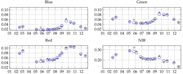
Object-based classification of grasslands from high
resolution satellite image time series using Gaussian
mean map kernels
Mailys Lopes1*, Mathieu Fauvel1, Stéphane Girard2and David Sheeren1
1 Dynafor, University of Toulouse, INRA, INPT, INPT-EI PURPAN, 31326 Castanet Tolosan, France; mailys.lopes@inra.fr, mathieu.fauvel@ensat.fr, david.sheeren@ensat.fr.
2 Team Mistis, INRIA Rhône-Alpes, LJK, 38334 Montbonnot, France; stephane.girard@inria.fr.
* Correspondence: mailys.lopes@inra.fr; Tel.: +33-534-32-39-27 Academic Editor: name
Version June 12, 2017 submitted to Remote Sens.
Abstract:This paper deals with the classification of grasslands using high resolution satellite image
1
time series. Grasslands considered in this work are semi-natural elements in fragmented landscapes,
2
i.e., they are heterogeneous and small elements. The first contribution of this study is to account for
3
grassland heterogeneity while working at the objectlevelby modeling its pixels distributions by a
4
Gaussian distribution. To measure the similarity between two grasslands, a new kernel is proposed
5
as a second contribution: the α-Gaussian mean kernel. It allows to weight the influence of the
6
covariance matrix when comparing two Gaussian distributions. This kernel is introduced in Support
7
Vector Machine for the supervised classification of grasslands from south-west France. A dense
8
intra-annual multispectral time series of Formosat-2 satellite is used for the classification of grasslands
9
management practices, while an inter-annual NDVI time series of Formosat-2 is used forold and
10
younggrasslands discrimination. Results are compared to other existing pixel- and object-based
11
approaches in terms of classification accuracy and processing time. The proposed method shows
12
to be a good compromise between processing speed and classification accuracy. It can adapt to the
13
classification constraints and it encompasses several similarity measures known in the literature. It is
14
appropriate for the classification of small and heterogeneous objects such as grasslands.
15
Keywords: Supervised classification; SVM; Gaussian mean map kernels; kernel methods; object
16
analysis; grasslands.
17
1. Introduction
18
Grasslands are semi-natural elements that represent a significant source of biodiversity in farmed
19
landscapes [1–4]. They provide many ecosystem services such as carbon storage, erosion regulation,
20
food production, crop pollination, biological regulation of pests [5], which are linked to their plant and
21
animal composition.
22
Different factors impact on grassland biodiversity conservation. Among them, the age of a
23
grassland (i.e, the time since last ploughing/sowing) is directly related to its plant and animal
24
composition. Old "permanent" grasslands, often called semi-natural grasslands, hold a richer
25
biodiversity than temporary grasslands [2,6–8]. Indeed, they had time to establish and stabilize their
26
vegetation cover, contrarily to temporary grasslands which are part of a crop rotation. Additionally,
27
agricultural management of grasslands (i.e, mowing, grazing, fertilizing, reseeding...) influences their
28
structure and composition [9–12]. Management is essential for their biodiversity conservation because
29
its prevents from the woody establishment. Conversely, an intensive use constitutes a threat for this
30
biodiversity [12,13]. Therefore, it is important to know the age of a grassland and to identify the
31
management practices in order to monitor their effect on biodiversity and related services. But these
32
factors are defined at different temporal scales: over the years for the age of a grassland, and during a
33
vegetation season (i.e., a year) for the management practice.
34
Usually, ecologists and agronomists characterize grasslands at the parcel scale through field
35
surveys. However, these surveys require important human and material resources, the knowledge of
36
the assessor and a sampling strategy, which make them expensive and time-consuming [14]. They are
37
thus limited in spatial extent and in temporal frequency, limiting grassland characterization to a local
38
scale and over a short period of time.
39
Conversely, remote sensing offers the possibility to provide information on landscapes over large
40
extents, thanks to the broad spatial coverage and regular revisit frequency of satellite sensors [15]. In
41
this context, satellite images have already appeared to be an appropriate tool to monitor vegetation
42
over large areas with a high temporal resolution.
43
In the remote sensing literature, grasslands have relatively not been studied much compared to
44
other land covers like crops or forest [16]. Most of studies focusing on grasslands have agronomic
45
applications, such as estimating biomass productivity and growth rate [17–19] or derivating biophysical
46
parameters likeLeaf Ara Index(LAI),Fraction of Photosynthetically Active Radiation(fPAR) and
47
chlorophyll content [20–24]. Studies having biodiversity conservation schemes such as assessing plant
48
diversity and plant community composition in a grassland are usually based on ground spectral
49
measurements or airborne acquisitions at a very high spatial resolution [25–31]. However, such
50
acquisitions are time-consuming and expensive and thus they do not allow for continuous monitoring
51
of grasslands over the years.
52
Using satellite remote sensing images, grasslands have been studied a lot at a regional scale with
53
medium spatial resolution sensors (i.e., MODIS, 250m/pixel [17,18,32]), where the Minimum Mapping
54
Unit (MMU) is at least of hundreds of meters. This scale is suitable for large, extensive, homogeneous
55
and contiguous regions like steppes [33], but not for fragmented landscapes which are usually found
56
in Europe and in France particularly [34,35]. These fragmented landscapes are made of a patchwork
57
of different land covers which have a small area [35]. In these types of landscapes, grasslands can
58
be smaller (less than 10,000m2) than the pixel resolution [36] (see Figure1for a graphical example).
59
As a consequence, pixels containing grasslands are usually a mixture of other contributions, which
60
can limit the analysis [37,38]. As examples, Poças et al. [39] had to select large contiguous areas of
61
semi-natural grasslands in a mountain region of Portugal to be able to use SPOT-VEGETATION data
62
(1-km resolution). Halabuk et al. [40] also had to select only one MODIS pixel per homogeneous
63
sample site in Slovakia to detect cutting in hay meadows. A 30-m pixel resolution is still not sufficient
64
for grassland characterization. Indeed, Lucas et al. [41] and Toivonen and Luoto [42] showed that it
65
was more difficult to classify fragmented and complex elements [43], like semi-natural grasslands, than
66
homogeneous habitats, using Landsat imagery. Price et al. [44] classified six grassland management
67
types in Kansas using six Landsat images, but the accuracy of the classification was not satisfying (less
68
than 70%). Therefore, to detect small grasslands in fragmented landscapes, high spatial resolution
69
images are required [36,45,46].
70
(a) (b)
Figure 1.Digitalized grasslands (in red) from the dataset used in this study on (a) a Sentinel-2 image (10m pixel resolution) and (b) a MODIS image (250m).
For high spatial resolution images (about 10m/pixel), few intra-annual images are usually
71
available for a given location [47]. However, Buck et al. [48] concluded that three RapidEye images per
72
year were not enough to detect the mowing practices in grasslands. It was confirmed by Franke et al.
73
[49]who classified grassland use intensity into four categories: Semi-natural Grassland, Extensively
74
Used Grassland, Intensively Used Grassland and Tilled Grassland. They increased the classification
75
accuracy when increasing the number of RapidEye images from three to five scenes. Additionally,
76
Schmidt et al. [50] concluded that about seven to ten images, depending on the vegetation index used,
77
are a good tradeoff between the amount of satellite data and classification accuracy of grassland use
78
intensity.Some works report results with few images per year, such as Dusseux et al. [51], but they
79
worked on LAI. In their study for mapping grassland habitat using intra-annual RapidEye imagery,
80
Schuster et al. [52] concluded the more acquisition dates used, the better the mapping quality.
81
Given the heterogeneity of grasslands in fragmented landscapes, their phenological cycle and the
82
punctuality of the anthropogenic events (e.g., mowing), dense high spatial resolution intra-annual time
83
series are necessary to identify the grassland management types [36,52–54]. Moreover, to discriminate
84
semi-natural grasslands from temporary grasslands, inter-annual time series are necessary. Until
85
recently, satellite missions offering high revisit frequency (1-16 days) had coarse spatial resolution
86
(i.e., NOAA AVHRR - 1km, MODIS - 250/500m). Conversely, high spatial resolution missions did
87
not provide dense time series and/or were costly (i.e., QuickBird, RapidEye). For these reasons
88
and compared to crops, grasslands differentiation through Earth observations is still considered as a
89
challenge [52]. However, new missions like Sentinel-2 [55], with very high revisit frequency (5 days)
90
and high spatial resolution (10 meters in four spectral channels, 20 meters in six channels) provide
91
new opportunities for grasslands monitoring over the years in fragmented landscapes [54] at no cost,
92
thanks to the ESA free data access policy. For instance, the high spatial resolution is assumed to make
93
possible the identification of grassland-only pixels in the image and several pixels can belong to the
94
same grassland plot. Hence, the analysis can be done at the objectlevel, not at the pixellevel, which is
95
suitable for landscape ecologists and agronomists who usually study grasslands at the parcel scale [56].
96
Thus, object-oriented approaches are more likely to characterize grasslands ecologically [57,58]. Yet, a
97
lot of works consider pixel-based approaches without any spatial constraints [17,42,44,48,49,52,59].
98
At the objectlevel, grasslands are commonly represented by their mean NDVI [18]. But such
99
representation might be too simple since it does not account for the heterogeneity in a grassland.
100
Sometimes, distributions of pixels as individual observations are still better than the mean value
101
to represent grasslands, as in [54]. Lucas et al. [41] used a rule-based method on segmented areas
102
for habitat mapping but it did not work well on complex and heterogeneous land covers. Esch et
103
al. [60] also used an object-oriented method on segmented elements then represented by their mean
104
NDVI. These methods based on mean modeling do not capture well grasslands heterogeneity. Other
105
representations can be found in the literature, taking standard deviation and object texture features as
106
variables [61], but they were not applied to time series. In our knowledge, these methods do not use
107
the high spatial and the high temporal resolutions jointly. Moreover, all these studies used vegetation
108
indices as a variable, although it has been shown that classification results are better when using more
109
spectral information [35,62].
110
To deal with the high spatio-spectro-temporal resolutions new satellite sensors are now offering,
111
dimension reduction is usually performed through the use of a vegetation index such as NDVI [50,52,63,
112
64], PCA [65] or spectro-temporal metrics [35,66]. But a large amount of spectro-temporal information
113
is lost with these solutions. Franke at al. [49] developed an indicator of the spectral variability of a pixel
114
over the time series, the Mean Absolute Spectral Dynamics, but its efficiency was assessed using a
115
decision tree algorithm. Decision trees are usually not recommended because they tend to over-fit the
116
data [67]. Therefore, the high spatio-spectro-temporal resolutions have not really been addressed in
117
the literature of remote sensing classification. Indeed, such time series bring new methodological and
118
statistical constraints given the high dimension of data (i.e., number of pixels and number of spectral
119
and temporal measurements). Dealing with more variables increases the number of parameters to
estimate, increasing the computation time and making the computation unstable (i.e., ill-conditioned
121
covariance matrices...) [68,69]. Hence, conventional models are not appropriate if one wants to use
122
all the spectro-temporal information of time series with high spatial and temporal resolutions. Thus,
123
classifying grasslands with this type of data is still considered as a challenge [52].
124
In the present study, we introduce a model suitable for the classification of grasslands using
125
satellite image time series (SITS) with a high number of spectro-temporal variables (e.g., Sentinel-2
126
data). Two temporal scales are considered in this work: (i) an inter-annual time series of three years to
127
discriminateoldgrasslands fromyounggrasslands and (ii) an intra-annual time series to identify the
128
management practices. Note that in this work, the objects are not found from segmentation [38] but
129
from existing dataset in a polygon form.
130
The first contribution of this study is to model a grassland at the objectlevelwhile accounting
131
for the spectral variability within a grassland. We consider that the distribution of the pixel spectral
132
reflectance in a given grassland can be modeled by a Gaussian distribution. The second contribution
133
is to propose a measure of similarity between two Gaussian distributions that is robust to the high
134
dimension of the data. This method is based on the use of covariance through mean maps. The
135
last contribution is the application of the method toold and younggrasslands discrimination and of
136
management practices classification, which are non common applications in remote sensing. Moreover,
137
in our knowledge, mean maps have not yet been used on Gaussian distributions for supervised
138
classification of SITS at the objectlevel.
139
In the next section, the materials used for the experimental part of this study are presented.
140
Then the methods, including the different types of grassland modeling and the measures of similarity
141
between distributions are introduced in section3. Following that, we experiment theproposed
142
methodson the classification of a real dataset in section4. Finally, conclusions and prospects are given
143 in section5. 144 2. Materials 145 2.1. Study site 146
The study site is located in south-west France, near the city of Toulouse (about 30km), in a
147
semi-rural area (center coordinates: 43◦2703600N 1◦802400E, Figure2). This region is characterized by a
148
temperate climate with oceanic and Mediterranean influences. The average annual precipitation is
149
656mm and the average temperature is 13◦C. The north of the site, closer to the urban area of Toulouse,
150
is flat, whereas the south-west of the site is hilly. The eastern part corresponds to the Garonne river
151
floodplain and this location is dominated by crop production. Within this study site, livestock farming
152
is declining in favor of annual crop production. Grasslands are mostly used for forage or silage
153
production. Some grasslands, located in the south-western part of the area, are pastures for cattle or
154
sheep. The extent of the area is included in the satellite image extent (Figure2) and is about 24×24km2.
155
2.2. Satellite data
156
Time series of Formosat-2 were used is this experiment. Formosat-2 has four spectral bands with
157
an 8meter spatial resolution: B1 "Blue" (0.45 0.52µm), B2 "Green" (0.52 0.6µm), B3 "Red" (0.63
-158
0.69µm), B4 "Near Infra-Red (NIR)" (0.76 - 0.9µm). The extent of an acquisition is 24km×24km. The
159
images were all acquired with the same viewing angle. They were orthorectified, radiometrically and
160
atmospherically corrected by the French Spatial Agency (CNES). They were provided by the Center
161
for the Study of the Biosphere from Space (CESBIO) in reflectance with a mask of clouds and shadows
162
issued from the MACCS (Multi-sensor Atmospheric Correction and Cloud Screening) processor [70],
163
in the frame of the Kalideos project.
164
For the inter-annual analysis, we used all the acquisitions of the consecutive years 2012 (13
165
observations), 2013 (17 observations) and 2014 (15 observations) (Figure3 and Figure S1 in the
166
supplementary materials). The acquisitions of year 2013 and of year 2014 were used separately for the
167
classification of management practices.
168
To reconstruct the time series due to missing data (clouds and their shadows), the Whittaker
169
filter [71] was applied pixel-by-pixel on the reflectances in each spectral band for each year
170
independently. The Whittaker filter is a non-parametric filter which has a smoothing parameter
171
that controls the roughness of the reconstructed curve. It has been successfully applied to smooth
172
NDVI time series in the literature [72–75].The smoother was adapted for unequally spaced intervals
173
and accounted for missing data (see [62] for a detailed description of the method). The smoothing
174
parameter was the same for all the pixels. It was equal to 105for year 2013 and to 104for 2012 and
175
2014, after an ordinary cross-validation done on a subset of the pixels for each year. An example of
176
smoothing on a grassland pixel is provided in Figure4. This pixel is hidden by a light cloud during
177
one image acquisition (red cross). Notice that the smoothing is done at the cost of under-estimating
178
the local maxima of the temporal profile.
179
03 05 07 09 11 03 05 07 09 11 03 05 07 09 11
2012 2013 2014
Figure 3.Formosat-2 acquisition dates in 2012 (green dots), 2013 (blue dots) and 2014 (red dots) used in this experiment. 01 02 03 04 05 06 07 08 09 10 11 12 0.02 0.04 0.06 0.08 0.10 Blue 01 02 03 04 05 06 07 08 09 10 11 12 0.02 0.04 0.06 0.08 0.10 Green 01 02 03 04 05 06 07 08 09 10 11 12 0.02 0.04 0.06 0.08 0.10 Red 01 02 03 04 05 06 07 08 09 10 11 12 0.20 0.30 NIR
Figure 4.Example of time series reconstruction (blue dots) with Whittaker smoother for a pixel of a grassland in the four spectral bands. The black crosses correspond to the original 2013 Formosat-2 time series and the red ones correspond to missing/noisy data due to the clouds. The x-axis represents the month of year 2013 and the y-axis is the reflectance.
For the intra-annual time series, we used all the spectral information. Therefore, the smoothed
180
time series associated with each of the four spectral bands were concatenated to get a unique time
181
series per pixel. For the inter-annual time series, as using all the spectral bands would result in a too
182
large number of variables to process, we worked on the NDVI, computed from the red and NIR bands.
183
2.3. Reference data
184
2.3.1.Old and young grasslands
185
In this study, "old" grasslands are 14 years old or more, whereas "young" grasslands are less
186
than five years old. The French agricultural land use database (Registre Parcellaire Graphique) was
187
used to extract the grasslands depending on their age. It registers on an annual basis the cultivated
188
areas declared by the farmers in a GIS. Grasslands are declared as "permanent" or "temporary".
189
Permanent grasslands are at least five years old, whereas temporary grasslands are less than five
190
years old (Commission Regulation EU No 796/2004). For every plot declared as a grassland in 2014,
191
its age was computed from the previous years declarations. We kept only the grasslands which
192
were at least 14 years old in 2014 ("old"), and the grasslands which were less than 5 years old in
193
2014 ("young"). A negative buffer of 8 meters was then applied to all the polygons to eliminate
194
the edge effects (Figure 5). Then they were rasterized using the GDAL command gdal_rasterize
195
(http://www.gdal.org/gdal_rasterize.html) to obtain the pixels inside each grassland. Only the
196
grasslands having an area of at least 1,000m2were kept to ensurea minimum number of 16 pixels to
197
represent each grassland. In the end, there were 59oldgrasslands (at least 14 years old) and 416young
198
grasslands (Table1), for an average area of about 26,600m2.
199
(a) (b)
(c) (d)
Figure 5.False color Formosat-2 images of the same grassland on two close dates (June and October) in 2013 and 2014 with the same color scale. (a) 2013-06-06, (b) 2013-10-27, (c) 2014-06-05, (d) 2014-10-23. The blue line represents the polygon limits of the grassland.
Table 1.Composition of theold and younggrasslands dataset.
Class Nb of grasslands Nb of pixels
Old 59 31,166
Young 416 129,348
Total 475 160,514
2.3.2. Management practices
200
The information of the agricultural practices performed in the crops are not featured in the
201
land use database. Therefore, this dataset comes exclusively from field data. As mentioned in the
introduction, ground data is difficult to obtain in ecology since field work is fastidious. A field survey
203
was conducted in May 2015 to determine the past and current management practices of 52 grasslands
204
by interviewing the farmers or grasslands’ owners. The practices remained stable for the years 2013
205
and 2014. Four management types during a vegetation cycle were identified: one mowing, two
206
mowings, grazing and mixed (mowing then grazing). We eliminated the type "two mowings" of the
207
dataset because of its under-representation (only three grasslands).
208
The management types were used as classes for the classification (Table2). The grasslands were
209
digitalized manually after field work. A negative buffer of 8 meters was then applied to eliminate the
210
edge effects, before rasterizing the polygons. The average grasslands surface area is about 10,000m2.
211
The smallest grassland is 1,632m2(which represents 25 Formosat-2 pixels) and the largest is 47,111m2
212
(735 pixels) (Figure6).
213
Table 2.Grassland management types and composition of the dataset.
Class Nb of grasslands Nb of pixels
Mowing 34 6,265 Grazing 10 1,193 Mixed 8 1,170 Total 52 8,628 0 200 400 600 800 0 5 10 15 ni Number of grasslands
Figure 6.Histogram of grasslands size in number of pixels ni. The red line corresponds to the number of spectro-variables d=68 in 2013.
3.Methods
214
3.1. Grassland modeling
215
In this work, each grassland giis composed of a given number niof pixels xik∈ Rd, where k is the
216
pixel index such as k ∈ {1, ..., ni}, i∈ {1, . . . , G}, G is the total number of grasslands, N=∑Gi=1niis
217
the total number of pixels, d=nBnTis the number of spectro-temporal variables, nBis the number of
218
spectral bands and nTis the number of temporal acquisitions. In the experimental part, when working
219
on the intra-annual time series of 2013 using the four spectral bands, d=4×17=68. In 2014, d=
220
4×15=60. When working on the inter-annual times series using NDVI, d=1× (13+17+15) =45.
221
With each grassland giare associated a matrix Xiof size(ni×d)and a response variable yi∈ Rwhich
222
corresponds to its class label.
223
In the following, two types of grassland modeling are discussed, at the pixelleveland at the
224
objectlevel. A more informative objectlevelmodeling is then proposed.Then, similarity measures are
225
discussed.
3.1.1. Pixellevel
227
The representation of a grassland at the pixellevelhas been used a lot in the remote sensing
228
literature [17,42,44,48,49,52,59]. The grassland can either be represented by all its pixels or by one pixel
229
when the spatial resolution of the pixel is too coarse, see for instance [39,40]. In this representation,
230
a sample is a pixel. Therefore, with each xikis associated the response variable yi of gi, but xikis
231
processed independently of all other xik0of gi. However, this representation usually leads to aberrant
232
classification results (e.g., salt and pepper effect) [38], which are not expected when working at the
233
grasslandlevel.
234
3.1.2. Objectlevel
235
At the objectlevel, the mean vector µiof the pixels belonging to giis generally used to represent
236
gi. It is estimated empirically by:
237 ˆµi= 1 ni ni
∑
l=1 xil. (1)In this case, a vector ˆµi ∈ Rdand a response variable y
i ∈ Rare associated with each grassland.
238
This representation might be limiting for heterogeneous objects such as grasslands since the
239
spectro-temporal variability is not encoded. To illustrate this bias, Figure7shows on the left the
240
set of pixels values in the NIR band for two grasslands (a and b). From this figure, it can be seen that if
241
the mean vector captures the average behavior, higher variability can be captured by including the
242
variance/covariance (middle and right plots). The figure shows that the first and second eigenvectors
243
of the covariance matrix capture well the general trend in the grassland and the main variations due to
244
different phenologic behaviors in the grassland. This information cannot be recovered by considering
245
the variance feature only: covariance must also be included.
246
In this study, to account for the spectro-temporal variability, we assume that the distribution of
247
pixels xiis, conditionally to grassland gi, a Gaussian distributionN (µi,Σi), whereΣiis the covariance
248
matrix estimated empirically by:
249 ˆ Σi= 1 ni−1 ni
∑
l=1 (xil− ˆµi)(xil−ˆµi)>. (2)In this case, we associate with each giits estimated distributionN (ˆµi, ˆΣi)and a response variable
250
yi ∈ R. The Gaussian modeling encodes first and second order information on the grassland by
251
exploiting the variance-covariance information. It is worth noting that if we constraint ˆΣi =Id, the
252
identity matrix of size d, for i∈ [1, . . . , G], the Gaussian modeling is reduced to the mean vector. In the
253
following,N (ˆµi, ˆΣi)is denoted byNi.
254
3.2. Similarity measure
255
3.2.1. Similarity measure between distributions
256
For classification purposes, a similarity measure between each pair of grasslands is required.
257
With pixel-based or mean modeling approaches, conventional kernel methods such as Support Vector
258
Machine (SVM) with a Radial Basis Function (RBF) kernel can be used since the explanatory variable
259
is a vector. However for a Gaussian modeling, i.e., when the explanatory variable is a distribution,
260
specific derivations are required to handle the probability distribution as an explanatory variable.
261
Many similarity functions generally used to compare two Gaussian distributions (e.g.,
262
Kullback-Leibler divergence [76], Jeffries-Matusita distance which is based on Bhattacharyya
263
distance [77]) require the inversion of the covariance matrices and the computation of their
264
determinants. For a conventional multivariate Gaussian model, the number of parameters to estimate
02 03 04 05 06 07 08 09 10 11 12 0.2 0.4 02 03 04 05 06 07 08 09 10 11 12 0.2 0.4 02 03 04 05 06 07 08 09 10 11 12 0.2 0.4 (a) 02 03 04 05 06 07 08 09 10 11 12 0.2 0.4 02 03 04 05 06 07 08 09 10 11 12 0.2 0.4 02 03 04 05 06 07 08 09 10 11 12 0.2 0.4 (b)
Figure 7. Examples of 2013 time series evolution in the NIR reflectance band of Formosat-2 for a grassland of management practice (a) "mowing" and (b) "grazing". The x-axis is the month of the year. The y-axis is the NIR reflectance value. The plot on the left shows the evolution of all the pixels in the grassland and the temporal mean of these pixels in red. The plot in the middle shows the temporal mean in red, the temporal mean+0.2×the first eigenvector in blue and the temporal mean−0.2×the first eigenvector in black. The plot on the right shows the temporal mean in red, the temporal mean +0.2×the second eigenvector in blue and the temporal mean−0.2×the second eigenvector in black.
for each grassland is d(d+3)/2(d parameters for the mean vector and d(d+1)/2 parameters for the
266
symmetric covariance matrix). In the case where d is large, the number of parameters to estimate can
267
be much larger than the number of samples, making the inverse problem ill-posed. This issue is faced
268
in this study because grasslands are small elements of the landscape. They are characterized by a
269
number of spectro-temporal variables which is about of the same order as the number of pixels ni(see
270
Figure6). Therefore, most of the estimated covariance matrices are singular and their determinants are
271
null. Hence, conventional similarity measures used for moderate dimensional Gaussian distributions
272
are not suitable for high dimensional Gaussian distributions. In the following, we propose to use
273
mean map kernels and we introduce a derivation of mean map kernels to weight the influence of the
274
covariance matrix.
275
3.2.2. Mean map kernels between distributions
276
Mean map kernels are similarity measures which operate on distributions [78]. They have
277
been used in remote sensing for semi-supervised pixel-based learning in [79]. In their work, the
278
authors define the similarity between two distributions piand pjas the average of all pairwise kernel
279
evaluations over the available realizations of piand pj(i.e., pixels that belong to grasslands gior gj). It
280
corresponds to the empirical mean kernel [79, eq.(8)]:
281 Ke(pi, pj) = 1 ninj ni,nj
∑
l,m=1 k(xil, xjm), (3)where niand njare the number of pixels associated with piand pjrespectively, xilis the lthrealization
282
of pi, xjmis the mthrealization of pjand k is a semi-definite positive kernel function.
It is possible to include prior knowledge on the distributions by considering the generative mean 284 kernel [78]: 285 Kg(pi, pj) = Z Rd Z Rd k(x, x0)ˆpi(x)ˆpj(x0)dxdx0. (4) Note that eq. (3) acts on the realizations of piwhile eq. (4) acts on its estimation. When dealing with a
286
large number of samples, the latter can drastically reduce the computational load with respect to the
287
former.
288
In our grassland modeling, piand pjare assumed to be Gaussian distributions. In that case, if k is
289
a Gaussian kernel such as k(x, x0) =exp(−γ
2kx−x0k2), eq. (4) reduces to the so-called Gaussian mean
290 kernel [80]: 291 KG(Ni,Nj) = exp −0.5(ˆµi−ˆµj)T ˆΣi+Σˆj+γ−1Id −1 (ˆµi−ˆµj) |Σˆi+Σˆj+γ−1Id|0.5 , (5) where γ is a positive regularization parameter coming from the Gaussian kernel k and| · |stands for
292
the determinant.
293
This kernel is not normalized, i.e., KG(Ni,Ni) 6=1, but the normalization can be achieved easily:
294 ˜ KG(Ni,Nj) = KG(Ni,Nj) KG(N i,Ni)0.5KG(Nj,Nj)0.5 = KG(Ni,Nj)|2 ˆΣi+γ−1Id|0.25|2 ˆΣj+γ−1Id|0.25. (6) With respect to the Kullback-Leibler divergence (KLD) and the Jeffries-Matusita distance (JMD),
295
the Gaussian mean kernel introduces a ridge regularization term γ−1Idin the computation of the inverse
296
and of the determinant [81]. Thus, the Gaussian mean kernel is more suitable to measure the similarity
297
in a high dimensional space than KLD and JMD. The value of γ tunes the level of regularization. It is
298
tuned during the training process as a conventional kernel parameter.
299
However, in the case of very small grasslands, two problems remain. The first lies in the ridge
300
regularization: in this case, so low γ values are selected that it becomes too much regularized and it
301
deteriorates the information. The second problem is that the estimation of the covariance matrix has
302
a large variance when the number of samples used for the estimation is lower than the number of
303
variables. Therefore, the covariance matrix becomes a poorly informative feature. In the following, we
304
propose a new kernel function that allows to weight the covariance features with respect to the mean
305
features.
306
3.2.3. α-Gaussian Mean Kernel
307
Depending on the level of heterogeneity and the size of the grassland, the covariance matrix could
308
be more or less important for the classification process. We propose a kernel including an additional
309
positive parameter α which allows to weight the influence of the covariance matrix, the α-generative
310 mean kernel: 311 Kα(p i, pj) = Z Rd Z Rd k(x, x0)ˆpi(x)(α −1) ˆpj(x0)(α −1) dxdx0. (7)
When piand pjare Gaussian distributions, k is a Gaussian kernel and the normalization is applied,
312
the expression gives rise to the α-Gaussian mean kernel:
˜ Kα(N i,Nj) = exp −0.5(ˆµi−ˆµj)Tα(Σˆ i+Σˆj) +γ−1Id −1 (ˆµi− ˆµj) |α(Σˆi+Σˆj) +γ−1Id|0.5 |2α ˆΣi+γ−1Id|0.25|2α ˆΣj+γ−1Id|0.25. (8) The proof is given in the appendix. It is interesting to note that particular values of α and γ lead to
314
known results:
315
1. α=0: In this case, eq. (8) reduces to the Gaussian kernel between the mean vectors. It becomes
316
therefore equivalent to an object modeling where only the mean is considered.
317
2. α=1: It corresponds to the Gaussian mean kernel defined in eq. (6).
318
3. α→ +∞: We get a distance which works only on the covariance matrices. It is therefore equivalent
319
to an object modeling where only the covariance is considered.
320
4. γ → +∞ and α = 2: The α-Gaussian mean kernel simplifies to a RBF kernel built with the
321
Bhattacharyya distance computed betweenNiandNj.
322
This proposed kernel thus includes several similarity measures known in the literature.
323
Furthermore, new similarity measures can be defined by choosing different parameters configuration.
324
The α-Gaussian mean kernel (αGMK) is therefore more flexible since it can adapt to the classification
325
constraints:
326
• Whether the heterogeneity of the object is relevant or not,
327
• Whether the ratio between the number of pixels and the number of variables is high or low.
328
4. Experiments on grasslands classification
329
In this section, the experiments for grassland classification are detailed. We first introduce the
330
seven competitive methods, then the classification protocol is described and we finally present and
331
discuss the results.
332
4.1. Competitive methods
333
Several existing pixel-based and object-based classification methods using SVM are presented
334
below. They are compared to assess the effectiveness of the proposed object-based method which relies
335
on the weighted use of the covariance matrix, αGMK, for the classification of grasslands.
336
4.1.1. Pixel-based and mean modeling
337
These conventional methods use a RBF kernel.
338
• PMV(Pixel Majority Vote): The pixel-based method was described in section3.1.1. It classifies
339
each pixel with no a priori information on the object which the pixel belongs to. In order to
340
compare to other objectlevelmethods, one class label is extracted per grassland by a majority
341
vote done among the pixels belonging to the same grassland.
342
• µ(mean): The distribution of the pixels reflectance of giis modeled by its mean vector µi(see
343
section3.1.2).
344
4.1.2. Divergence methods
345
These methods are based on a distance D between two Gaussian distributions. They are used in a
346
Gaussian kernel such as KD(Ni,Nj) =exp(− D2
ij
σ ), with σ>0:
347
• HDKLD(High Dimensional Kullback-Leibler Divergence): This method uses the Kullback-Leibler
348
divergence for Gaussian distributions with a regularization on covariance matrices such as
349
described in [82].
• BD(Bhattacharyya Distance): This method uses the Bhattacharyya distance in the case of Gaussian 351 distributions: 352 B(Ni,Nj) = 1 8(ˆµi−ˆµj) > ˆΣi+Σˆj 2 −1 (ˆµi−ˆµj) +1 2ln | ˆ Σi+ ˆΣj 2 | |Σˆi|0.5|Σˆj|0.5 .
Small eigenvalues of the covariance matrices are shrinked to the value 10−5 to make the
353
computation tractable [83].
354
4.1.3. Mean map kernel based methods
355
These methods are based on mean map kernels presented in section3.2:
356
• EMK(Empirical Mean Kernel): This method uses the empirical mean map kernel of eq. (3) and it
357
is pixel-based.
358
• GMK(Gaussian Mean Kernel): This method is based on the normalized Gaussian mean kernel
359
(eq.6).
360
• αGMK(α-Gaussian Mean Kernel): This method is based on the proposed normalized α-Gaussian
361
mean kernel (eq.8).
362
Figure8illustrates the relationships between the different methods. The characteristics of each
363
method are synthesized in Table3.
364
For memory issues during the SVM process, the number of pixels processed for theold and young
365
grasslands classification was divided by 10 for the two methods based on pixels (PMV and EMK).
366
Only 1 pixel out of 10 was kept per grassland.
367 g Pixel PMV Object Realizations EMK Moments µ Σ N BD GMK HDKLD αGMK
Figure 8. Contribution of the proposed method in grassland analysis for supervised classification.
αGMK consists in a general modeling of the grassland at the objectleveland it encompasses several
known modelings. The underlined methods are tested in this study.PMV, EMK and µ are not based on Gaussian modeling while the others are.
Table 3.Characteristics of the methods used in this study.
Method PMV EMK µ HDKLD BD GMK αGMK
Level Pixel Object Object Object Object Object Object
Expl. variable xik xik µi Ni Ni Ni Ni
Kernel RBF RBF RBF KHDKLD KB K˜G K˜α
Parameters σ, C σ, C σ, C σ, C σ, C γ, C γ, α, C
4.2. Classification protocol
368
We compared the efficiency in terms of classification accuracy and processing time of all the
369
presented methods by classifying the two grassland datasets on inter-annual and intra-annual time
370
series (section2).
371
For each method, a Monte Carlo procedure was performed on 100 runs. For each run, the dataset
372
was split randomly into training and testing datasets (75% for training and 25% for testing), preserving
373
the initial proportions of each class. The same grasslands were selected for a given Monte Carlo
374
repetition regardless of the method.
375
During each repetition, the optimal parameters were tuned by cross-validation based on the best
376
F1 score. Table4contains the parameters grid search for all the methods. Note that a wide grid was
377
searched for the parameter α of αGMK to further analyze the distribution of selected values. The
378
penalty parameter C of the SVM process was chosen empirically and fixed to C =10, after running
379
several simulations. The classification accuracy for each repetition was assessed by the F1 score
380
computed from the confusion matrix. The overall accuracy (OA) was computed but it is not presented
381
here, because it does not reflect well the accuracy of the classification since unbalanced datasets were
382
used.
383
In order to compare each pair of methods, a Wilcoxon rank-sum test was processed on the pair of
384
distributions of the 100 F1 scores.This nonparametric test is designed for two independent samples
385
that are not assumed to be normally distributed [84]. It tests if the two samples are drawn from
386
populations having the same distribution.
387
The kernels and the SVM were implemented in Python through the Scikit library [85].
388
Table 4.Parameters tested for each method during cross-validation.
Method Parameters values
Inter-annual analysis Intra-annual analysis
PMV σ∈ {20, 21, . . . , 210} σ∈ {2−17, 2−16, . . . , 2−10} EMK σ∈ {20, 21, . . . , 210} σ∈ {2−18, 2−17, . . . , 2−10} µ σ∈ {20, 21, . . . , 210} σ∈ {2−18, 2−17, . . . , 2−10} HDKLD σ∈ {210, 211, . . . , 220} σ∈ {215, 216, . . . , 225} BD σ∈ {20, 21, . . . , 210} σ∈ {210, 211, . . . , 218} GMK γ∈ {20, 21, . . . , 210} γ∈ {2−17, 2−18, . . . , 2−10} αGMK γ∈ {20, 21, . . . , 210} γ∈ {2−18, 2−17, . . . , 2−13} α∈ {0, 0.1, 0.5, 1, 2, 5, 10, 15, 20, 25, 50} α∈ {0, 10−3, 10−2, 10−1, 0.3, 0.5, 0.7, 0.9, 1, 2, 5, 10, 15, 20, 25} 4.3. Results 389
4.3.1.Old and younggrasslands: inter-annual time series
390
Figure9sums up theold and younggrasslands classification results for each method over the
391
100 repetitions as a boxplot of F1 scores. The Kappa coefficients can be found in Figure S2 in the
392
supplementary materials. Since the cross-validation was not based on the Kappa coefficient, the results
393
are discussed in terms of F1 scores.The method reaching the best scores is αGMK with a F1 average of
394
0.71 followed by PMV and GMK with an average of 0.69.
395
Table5contains the Wilcoxon rank-sum test statistics between each pair of methods. It tests
396
the null hypothesis that the two sets of observations are drawn from the same distribution. The
397
null hypothesis is rejected if the test statistics is greater than 1.96 with a confidence level of 5%
398
(p-value < 0.05). In this case, it accepts the alternative hypothesis that values in one population are
399
more likely to be larger than the values from the other.The two best methods, αGMK and PMV are not
400
significantly different. But αGMK is significantly better than all the other methods, whereas PMV is
401
not significantly different than the mean map methods (EMK and GMK). The worst method is HDKLD
402
with a mean F1 of 0.59.
PMV EMK µ HDKLD BD GMKαGMK 0.4 0.6 0.8 F1
Figure 9.Boxplot of F1 score repartitions for the classification of theold and younggrasslands. The line in the box stands for the median whereas the dot stands for the mean.
Table 5. Absolute value of Wilcoxon rank-sum test statistics on F1 score for theold and young grasslands classification. ** indicates the results are significantly different, i.e., p-value < 0.05.
Method PMV µ HDKLD BD EMK GMK αGMK PMV - 3.52** 8.66** 4.83** 1.93 0.98 1.32 µ - 7.48** 1.76 1.55 2.28** 4.80** HDKLD - 5.68** 8.26** 8.65** 9.77** BD - 3.23** 3.95** 6.09** EMK - 0.94 3.35** GMK - 2.42** αGMK
-In terms of processing load and time, the pixel-based methods are clearly the most demanding.
404
Indeed, processing the 160,514 pixels was not possible with SVM, so we had to reduce the number
405
of samples. These issues are not faced with object-oriented methods. The fastest methods are µ and
406
HDKLD, but they did not reach acceptable classification accuracies. The best method in terms of ratio
407
accuracy/processing time is αGMK. It is appropriate for processing a large number of grasslands.
408
4.3.2. Management practices: intra-annual time series
409
The classifications accuracies for management practices are shown in Figure10(F1 score) and in
410
Figure S3 in the supplementary materials (Kappa coefficient)for year 2013 and for year 2014.
411
In terms of classification accuracy, methods based on divergences (BD and HDKLD) provided
412
the worst results. Pixel-based methods, mean modeling method and mean generative kernel methods
413
provided similar results in terms of F1 score, except for PMV which was significantly worse than the
414
others for the year 2013. αGMK provided the highest values in 2013 (average F1 of 0.65) but it was not
415
significantly better than the others for this dataset. Indeed, due to the very low number of grasslands
416
composing this dataset, confusion matrices were quite similar whatever the method. It is therefore
417
difficult to compare the methods efficiency in this configuration.
418
Nevertheless, this dataset makes possible the comparison in terms of processing times, because
419
the same spectral information was used for all the methods. Figure11illustrates the training processing
420
time relative to the one of PMV versus the average F1 score for each method. In terms of computational
421
time, the pixel-based methods required the largest processing times. BD was also very long, mainly
422
because of the shrinkage procedure. Mean modeling was the fastest, followed closely by HDKLD.
423
αGMK and GMK were equivalent in terms of computational times. For this configuration with a low
424
number of grasslands, the mean modeling was the most efficient in terms of accuracy/processing time
425
ratio.
PMV EMK µ HDKLD BD GMK αGMK 0.2 0.4 0.6 0.8 1 F1 PMV EMP µ HDKLD BD GMK αGMK 0.2 0.4 0.6 0.8 1 (a) (b)
Figure 10.Boxplot of F1 score repartitions for classification of management practices using time series of year (a) 2013 and (b) 2014. The line in the box stands for the median whereas the dot stands for the mean. 0 0.2 0.4 0.6 0.8 1 0.5 0.55 0.6 0.65 µ αGMK PMV HDKLD BD EMK GMK Relative time to PMV F1
Figure 11.Relative training processing times to PMV and average F1 of each method for intra-annual time series of 2013.
It is worth noting that the times series of 2014 produced higher classification accuracies(maximum
427
F1 average of 0.73 for GMK)than the time series of 2013(maximum F1 average of 0.65 for αGMK).
428
4.4. Discussion
429
The purpose of this work was to develop a model suitable for the classification of grasslands from
430
dense inter- or intra-annual SITS and robust to the dimension of the data. The proposed method based
431
on a weighted use of the covariance, namely αGMK, was compared to several competitive methods.
432
4.4.1. Methods efficiency
433
The methods efficiency are discussed for theold and younggrasslands classification,since the
434
results provided with the other dataset are not significantly different, mostly because of the small
435
dataset size.
436
The divergence methods (BD and HDKLD) provided the worst results, showing that they are not
437
robust enough to a high dimensional space.
438
Although they provided results close to the best results, pixel-based methods (PMV and EMK)
439
are the most demanding in terms of computational time and they do not scale well with the number of
440
pixels. Indeed, they have to process N pixels instead of G grasslands with GN. Therefore, we had
to reduce the number of pixels used for the classification. Using them on a large area might be difficult,
442
as theold and younggrasslands dataset showed.
443
Representing grasslands by the estimated distribution of their set of pixels decreases the
444
complexity during the SVM process. Therefore, objectlevelmethods offer a lower computational load
445
when compared to empirical mean kernels and pixel-based methods.
446
The mean generative kernel methods performed significantly better than the mean-only method
447
(µ). Among them, αGMK performed better than GMK. It was also one of the most stable methods.
448
In this context, including the covariance information helps to discriminate grasslands. However,
449
if the dimensionality is not properly handled, it deteriorates the process (e.g., BD and HDKLD). In this
450
case, it is preferable to use the mean values only. αGMK offers the possibility to weight the influence
451
of the covariance information compared to the mean. As a result, it provided better results than the
452
mean modeling and than GMK, since it encompasses both.
453
It is furthermore interesting to analyze the optimal values of the weightening parameter α found
454
during the cross-validation and the average of associated F1 scores (Figure 12). The highest F1 scores
455
were reached for high values of ˆα. The worst F1 scores were obtained with ˆα<2 and the value ˆα=0
456
was never selected. It shows the importance of the covariance information in grasslands modeling: the
457
heterogeneity in a grassland must be accounted for and it is not entirely well represented by the mean
458 only. 459 0.1 0.5 1 2 5 10 15 20 25 50 0 5 10 15 20 25 ˆα ˆαcount 0.6 0.65 0.7 A verage F1
Figure 12.Bar plot of ˆα values chosen by cross-validation and the average of associated F1 scores (red dots) for the classification ofold and younggrasslands using αGMK. NB: The value ˆα=0 was never selected.
4.4.2. Grassland modeling
460
Following on from the methods discussion, the choice of modeling grasslands pixels distribution
461
by a Gaussian distribution makes sense in this context. It is particularly well appropriate for
462
semi-natural grasslands, which are very heterogeneous, contrary to crops or annual "artificial"
463
grasslands which can be assimilated to crops.
464
However, modeling grasslands by the mean only produced equivalent results to the methods
465
based on Gaussian modeling for the classification of management practices,contrary to the old and
466
young grassland discrimination. Indeed, management practices are supposed to be uniform at the
467
grassland scale. Therefore the mean appears to be sufficient for this application, contrary to theold and
468
younggrasslands discrimination, which requires capturing more variations between the grasslands.
469
The best modeling might be different depending on the application. Moreover, some grasslands are so
470
small that the covariance matrix is too badly estimated.
471
In the proposed kernel, this modeling was made flexible by regularizing the weight given to the
472
covariance matrix. αGMK benefits from its high level of adaptability in front of the object configuration:
473
no choice has to be made between a Gaussian or a mean modeling since the method encompasses both.
It also includes several objectlevelmethods known in the literature. However, this is at the cost of one
475
more parameter to tune. Therefore, the classification process takes more time than GMK for instance.
476
Above all, although it is the first application of generative mean kernels in remote sensing
477
classification, the α-Gaussian mean kernel proved its efficiency and stability in these experiments.The
478
results suggestit is appropriate for grasslands classification.
479
4.4.3. Acquisition dates
480
For the management practice classification, using time series of 2014 produced better results
481
than using 2013. It might be explained by the acquisition dates in the time series. Although 2014
482
has less images, more clear images were acquired during Spring compared to 2013 which has a
483
lack of acquisitions in April and May (Figure3). Indeed, many studies showed that the best season
484
to discriminate grasslands is during the growing season [36,49,53,54]. Spring is the period of the
485
vegetation cycle where the management practices begin. Therefore, it is easier to differentiate the
486
practices during this period. It might thus affect the accuracy of the classification of year 2013.
487
It is not shown in this experiment, but using only one or two years of acquisitions to discriminate
488
old from younggrasslands did not produce sufficient classification accuracies. This is the reason
489
why three years of data were used. Old "permanent" grasslands are supposed to have a more stable
490
phenology over the years than the young "temporary" grasslands which have been recently sown
491
(less than five years) [6]. Theyounggrasslands phenology is closer to crops in their very first years.
492
We suppose this makes possible their discrimination with inter-annual SITS. However, the optimal
493
number of years needed to discriminate these types of grasslands could constitute a research topic.
494
In general, the results could also be enhanced by removing some winter images which can have
495
a negative influence on the entire annual time series [40]. However, the scope of this study was to
496
develop a method which is able to use a given time series, without having to process a date selection.
497
4.4.4. Grassland typology
498
On the whole, the classification did not reach high accuracies (F1 maximum average of 0.73 for
499
management practices and of 0.71 forold and younggrasslands classification). This can be explained
500
by the unbalanced dataset with under-representation of grazing and mixed grasslands in the first
501
application and under-representation ofoldgrasslands in the second one.These classes obtained the
502
lowest producer and user accuracies (cf. Tables S1 and S2 in the supplementary materials) because
503
of their limited number of samples for training the models.The methods should be tested on a more
504
balanced dataset of grasslands classes.
505
Moreover, as many times emphasized, semi-natural grasslands (which are present in these
506
datasets) are characterized by their high level of heterogeneity. Therefore, there might be a large amount
507
of intra-class variability because of grasslands diversity. The discrimination might be improved by
508
using more distinct classes: intensively used grasslands against extensively used grasslands, artificial
509
(monospecific) grasslands against semi-natural grasslands for instance.
510
4.4.5. Comparison with existing works
511
In our knowledge, only the work of Möckel et al. [86] relates to the classification of grasslands age
512
using remote sensing data. They reached a Kappa value of 0.77 in classifying three different grassland
513
age-classes. However, they used airborne hyperspectral data from a single date. Their recommendation
514
was to use multitemporal data to improve the classification or to use satellite hyperspectral data to
515
monitor grasslands over wider areas. Our study was based on using multispectro-temporal satellite
516
data, but our proposed method would also work with hyperspectral data.
517
As described in the introduction, few studies have been carried out on the analysis of semi-natural
518
grasslands using high spatio-spectro-temporal resolutions SITS. Usually, methods were pixel-based
519
and they were applied on a few images or on a precise date selection to avoid dealing with the high
dimension of data [42,44,49]. Schuster et al. [52] successfully classified grassland habitat using 21
521
RapidEye images on a pixel basis, but there was no mention of the processing times.
522
At the objectlevelusing a time series, grasslands were often represented by their mean NDVI,
523
such as in [60], who noticed the difficulty to discriminate grasslands from crops because of mean
524
seasonal NDVI similarities. The closest configuration might be the work of Zillman et al. [35], who
525
used an object-based analysis and spectral reflectances combined with seasonal statistics of vegetation
526
indices for mapping grasslands across Europe. The seasonal statistics were particularly relevant in the
527
classification, because they captured well the spectral diversity of the grassland phenology. The use of
528
these metrics could be considered for discriminating grassland management practices which impact on
529
the phenology. The authors also concluded that the object-based analysis improves the classification
530
compared to a pixel-based classification. However, the objects were determined by segmentation.
531
4.5. Prediction of management practices on the land use database grasslands
532
To show the efficiency of αGMK, we classified all the grasslands from the French agricultural land
533
use database (RPG) covered by the Formosat-2 time series to predict their management practice in 2014.
534
All the plots declared as grasslands in 2014, i.e., "permanent grassland" and "temporary grassland"
535
regardless of their age, were selected. After applying a negative buffer of 8m and rasterizing the
536
polygons, we removed the plots representing less than 10 Formosat-2 pixels. In the end, there were 797
537
grassland plots covered by the extent of Formosat-2 for a total of 252,472 pixels.
538
The multispectral SITS of 2014 was used. The SVM was trained on the whole field data
539
(section 2.3.2) using the same grid search as in the experiments. The parameters chosen after
540
cross-validation based on F1 score were ˆα=5 and ˆγ=2−15. Then, the model was used to predict the
541
management practices of the 797 grasslands of the land use database.
542
The classification accuracy could not be assessed since the true labels of the grasslands are not
543
known. However, as described in the study site, a spatial distribution of the classes could be expected.
544
Indeed, grazed and mixed grasslands should be found in the south-west of the site, whereas more
545
mown grasslands should be in the north.
546
An extract of the classification result is shown in Figure13. It represents the classified grasslands in
547
their raster format. As expected, most of the grazed and mixed grasslands are located in the south-west
548
of the image, whereas the north of the image is mostly composed of mown grasslands. Therefore,
549
αGMK was very likely able to classify with an acceptable accuracy the grasslands management
550
practices without any a priorigeographicinformation. However, specific care should be considered, as
551
not all the possible management practices were predicted. For instance, grasslands mown twice or
552
unused grasslands were not in the training dataset, but it does not mean these managements do not
553
exist in the rest of the data. The method deserves to be tested with an exhaustive grassland typology
554
to produce more detailed grasslands maps.
555
In terms of processing times, the proposed method is able to classify 800 grasslands, representing
556
more than 250,000 pixels, at the objectlevelfrom a high spatial resolution SITS within a few seconds
557
on a conventional personal computer.
558
5. Conclusion
559
This study aimed at developing a model for the classification of grasslands using satellite image
560
time series with a high number of spectro-temporal variables. A grassland modeling at the object
561
levelwas proposed. To deal with grasslands heterogeneity, their pixels distribution was modeled by
562
a Gaussian distribution. Then, to measure the similarity between two grasslands, i.e, two Gaussian
563
distributions, a kernel function based on mean maps was introduced, namely the α-Gaussian Mean
564
Kernel. The proposed method was compared to existing pixel-based and object-based classification
565
methods for the supervised classification of grassland using inter- and intra-annual SITS. The Gaussian
566
mean kernels provided the highest classification accuracies, showing that the covariance information
Figure 13. Extract of the management practices classification of the grasslands from the French agricultural land use database (RPG) in 2014. The background is a May, 2014 Formosat-2 image in the NIR channel.
must be accounted for. In terms of processing times, the object-based methods were much faster than
568
pixel-based methods.
569
Several contributions have been made in this work. The first lies in the grasslands pixels
570
distribution modeling at the objectlevel. A flexible kernel was proposed to encompass both Gaussian
571
and mean modeling of grasslands, so no choice has to be made between these two modelings. It can
572
therefore be used on homogeneous objects such as artificial grasslands, or on very small objects, as well
573
as on heterogeneous semi-natural grasslands. The second contribution is that this kernel is suitable for
574
high dimensional data in a small ground sample size context. It enables the use of all the multispectral
575
data instead of a single vegetation index or the use of a long time series. Also, it can be used on a
576
whole time series without dates selection. Indeed, this new kernel offers very low computational load.
577
It can therefore be applied on a large dataset. With this kernel, we were able to process and to classify
578
more than 250,000 pixels on a conventional personal computer within a few seconds. Even if it is the
579
first application of generative mean kernels in remote sensing classification, the αGMK proved its
580
efficiency and stability in these experiments. It is a good compromise between processing speed and
581
accuracy for the classification of grasslands.
582
The αGMK deserves to be tested on a larger dataset with more balanced classes. Seasonal statistics
583
could be used to improve the representation of grassland phenology. These ideas will be considered in
584
the future. This method was designed to deal with the dense SITS which will be provided by Sentinel-2
585
and to efficiently produce maps from this type of data. Other applications of the method are still
586
possible (e.g., small and heterogeneous objects such as peatlands, urban areas...).