Case Studies on Route 1: How the Perceived Identity of Local Commercial Strips Affects Zoning
by
Lily Baum Pollans B.A. Urban Studies Barnard College, 2001
SUBMITTED TO THE DEPARTMENT OF URBAN STUDIES AND PLANNING IN PARTIAL FULFILLMENT OF THE REQUIREMENTS FOR THE
DEGREE OF
MASTER IN CITY PLANNING
AT THE
MASSACHUSETTS INSTITUTE OF TECHNOLOGY JUNE 2005
© Lily Baum Pollans. All rights reserved.
The author hereby grants to MIT permission to reproduce and to distribute publicly paper and electronic copies of this thesis document in whole or in part.
Signature of Author: ---Depa Certified by: ---MASSACHUSETTS INSTITUTE OF TECHNOLOGY
JUN 2 8 2005
LIBRARIES
rtment of Urban Studies and Planning June 19, 2005
/
Tfry S. Szold Adjunct Associate Professor of Urban Studies and Planning,/I A Thesis Suoervisor
Accepted by: --- ---- D- Fr-- ---Professor of the Practice of Urban Studies and Planning
Case Studies on Route 1:
How the Perceived Identity of Local Commercial Strips Affects Zoning
Lily Pollans
Submitted to the Department of Urban Studies and Planning
on May 19, 2005 in Partial Fulfillment of the
Requirement for the Degree of Master in City Planning
Abstract:
Designers, planners, and new urbanists have often argued that highway strips, replete with big box retail and countless strip malls, are essentially placeless. It has also been argued that generic local zoning is largely to blame for existence and persistence of strips. While there may be some truth to these claims, every strip exists within a city, or town, or municipality, and has a unique relationship with that place. This thesis explores Route 1 through Dedham, Saugus and Peabody, MA to highlight that far from being interchangeable landscapes, the Route 1 strip varies from town to town, bearing distinctive marks of each town's approach to controlling it. These cases illustrate that a key variable in how heavily towns will rely on zoning to shape and control strip development is whether or not they view their strip as part of the town rather than as an outside entity. This thesis argues that, while it is true that variation between strip landscapes stems from zoning, the strip formula is not that simple: the way in which the towns write and implement their code derives from the perceived identity of each Route 1 strip, ultimately affecting the appearance of that strip.
Advisor: Terry S. Szold, Adjunct Associate Professor, Department Urban Studies and Planning Reader: Greg Morrow, Lecturer, Department of Urban Studies and Planning
Acknowledgements
To Fred Berroni, Ellen Burns, Mary Carfagna, Jean Delios, Katy Galinas, Janet Leuci, Arthur Noonan, Mike Parquette, Dan Shapiro, Joe Viola, and Peter Zahka, I thank you for taking time to share your experiences with me. Your words are the heart of
this thesis.
Thank you to Terry Szold and Greg Morrow for your patience and your unwavering efforts to steer me in the right direction. Thank you also to Mark
Schus-ter for setting me off on the right foot.
Karen and Solana, thanks for introducing me to the
matrix, for editing and pep-taking, and for listening to my midnight rants. Margs, this thesis would be
nowhere if it weren't for your comma revolution. Thacher, thank you for your tireless last minute
Table of Contents
Chapter 1: Introduction 9
1. Definitions 11. Case Studies
Ill. Scope and Limitations of Research
IV. Importance of Research V. Chapter Summary Chapter 2: Methodology 17 1. Introduction II. Phase 1 Ill. Phase 2 IV. Conclusion
Chapter 3: Background and Literature Review 23
1. Introduction
II. The Suburban Strip Ill. Strip Zoning
IV. Perceived Identity of Place V. Conclusion
Chapter 4: Existing Conditions and Zoning 33
1. Introduction H1. Zoning Regulations Ill. Existing Conditions IV. Zoning Implementation V. Conclusion
Chapter 5: Role of Perceived Identity 45 1. Introduction 11. Dedham Ill. Saugus IV. Peabody V. Conclusion Chapter 6: Conclusion 61 Bibliography 69
Appendix A: Demographics Table 75
Chapter 1: Introduction
Some sentimentalists will claim that Route 1 is America, that our great country
would be nowhere if not for strip zoning. - Bella English, Boston Globe Staff Writer,
The model of the human habitat dictated by zoning is a formless, soulless, centerless,
demoralizing mess. It bankrupts families and townships. It causes mental illness. It disables whole classes of decent, normal citizens. It ruins the air we breathe. It corrupts and deadens our spirits. - James Howard Kunstler, Home from Nowhere2
My interest in Route 1 stems from childhood cartrips
from Boston to Essex through Saugus, Lynnefield, Peabody and all the way up to Topsfield where Route 1 becomes a rural, two-lane New England road. As a child, I was thrilled by the kitschy signage and absurd sculpture. The roadside, filled
with fiberglass cacti, castles, and building facades that look like ships, is so rich with narrative and
imagery that it seemed to me that someone had
built this world entirely for my amusement.
Now, as a student of the built environment, I understand that this strip and others like it across the country are the subject of much contention and debate. As I have become aware of increasing
dialogue about the nature of strip development,
the remnants of this childhood fascination have
transformed into a broader interest in these
roadside environments, and their relationships to the towns in which they reside.
The quotes above introduce some of the recent discussion of contemporary strip development.
Both authors point to zoning as the source of the
form of commercial strip development. Much of
the recent literature treats strip zoning as a single,
simple phenomenon. Curious about whether
this was really the case, I planned to investigate
the degree to which dimensional requirements in commercial strip developments were predictors
for the actual appearance of the existing strip. I
expected that each town's strip would be similar
to the next town's, and that the codes in the three
towns I had selected would be comparable.
However, as I progressed in my research, I found that the formula was not as simple as I had imagined. Not only are the roadsides different in appearance
from town to town, but I also found significant variation in how much each town's zoning code attempts to regulate. Mounting evidence that strip development is in fact quite different from town to
town led me to wonder about the different kinds of
relationships that individual towns had with their strips. Does the way that communities feel about
to use zoning, ultimately affecting the amount of influence each town's zoning code has over its built
strip? More specifically, does the way in which town
officials and regulators perceive the identity of
Route 1 in their town affect the way towns write and
implement their zoning code, ultimately affecting
the appearance of their strips?
Simply, yes. Each of the three towns studied
here has a unique relationship with the regional highway that passes through it, and the attitudes
of town representatives are unmistakable variables contributing to how much each town uses zoning to control its strip. The case studies presented in
Chapters 3 and 4 will illustrate that while the stories
unfold differently, there is a pattern: towns that
view Route 1 as a part of the town use zoning more
aggressively to try and bring the image of the Route I strip into congruence with the image of the town;
towns that see Route 1 as something separate from the town do not rely on zoning heavily, since they
primarily view zoning as being appropriate only for development within more central parts of town.
I. Definitions
Before moving on I will provide some clarifying
definitions for the terms in the question and thesis statement above.
Firstly, I would like to define strip districts and strip
development. Dolores Hayden defines the strip as
''an arterial road lined with automobile oriented
uses." The term originated in the 1 920s, and has been called many things including the hot dog
trail and ribbon development.1 I use these terms to broadly encompass the modern iteration of this typology of development including both "strip malls"
and large scale commercial and retail development,
or big box, designed to be both experienced and
accessed from a car. Strip districts generally refer to the clusters of strip development that occur within
zoning districts designated at edges of regional
highways for this kind of development.
By perceived identity, I am referring to how regulators, town officials, and town planners view the identity
of the Route 1 strip. Even more specifically, I am
using perceived identity as a phrase to express how closely these regulators, officials, and planners link the image of Route 1 to the identity of the town as
a whole - i.e. do they see the Route 1 strip and the
town as the same; do they see Route 1 and the town
as completely separate entities, sharing nothing
but a tax base?
In terms of Zoning, for the purposes of this paper I
have focused on the dimensional requirements and
implementation mechanisms that pertain to the districts surrounding Route 1. By implementation of the zoning regulation, I am referring to the
mechanisms through which the codes are enforced
by town bodies, for example the strength of a site
plan review or the ease by which special permit
granting authorities dole out special permits. In
mean how specific their dimensional requirements are; how many individual measurements they
attempt to regulate; the degree to which the town has discretionary control over development approvals;
in other words, how much overall control over the physical environment the town assumes through
their zoning code.
II. Case Studies
This thesis will be based on the in depth study of the zoning code in three Route 1 cities and towns
in Massachusetts: Dedham, Peabody, and Saugus. All three towns share a bisecting regional highway and complimentary strips of highway development. Route 1 has cut through all of these towns since
they were unincorporated settlements, meaning that none of the towns suffered traumatic changes
due to the creation of the road. In addition to the
their locational and historical similarities, these
towns proved ideal case studies, because they are all very different places, with different planning resources, and notably different demographics (see Appendix A for a comparative table of basic town demographics). The different demographics, size and socio-economic composition of the towns serves to emphasize that the importance of the role
of perceived identity is consistent across different
kinds of cities and town. Also, the differences between the towns help to highlight each strip's uniqueness, and the similarities provide a strong basis by which to compare each town's relationship
with its Route 1.
Route 1, once known as the Boston Post Road, was
first trod by a horseman sent out of New York City to deliver the first official monthly post to Boston.
It took him two weeks to make the journey. About 100 years later, Benjamin Franklin set out in a horse and carriage with an odometer strapped to its wheel, and drove a stake into the ground every mile between Boston to New York, in order to convince users of the postal service that the per mile charge was fair.2 As time wore on, Route 1 stretched its
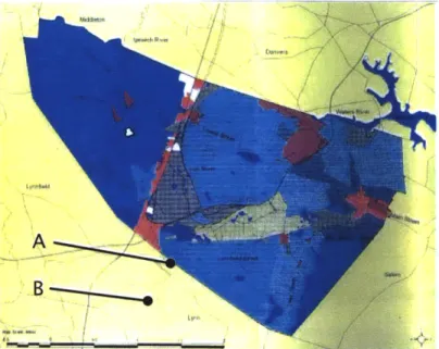
A *---.- -_-_Route 1
Figure 1: Boston area map showing case study town (Source: compiled by author with MIT GeoData).
sinews both northward and southward following a course laid by local roads along its path, ultimately
running the entire length of the eastern seaboard,
Maine to Florida. While each of the following
towns grew around this road, they have dealt very
differently with its presence.
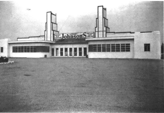
Dedham: Dedham was first settled by colonists
in the late seventeenth century. It remained a
predominantly agricultural community for the next two hundred years. During the nineteenth century, a full-fledged manufacturing industry began to grow
Figure 2: This Howard Johnson's on Route 1 in Dedham shows the style of
build-out prior to the 1 950s. (Source: Dedham Historical Society).
on Dedham's two major rivers, and the town began
exporting spun cotton, wool, wire, paper, carriages,
and other goods. The town was first built out as modest housing for mill workers' families. Even
though much of the town remained agricultural,
Dedham's basic form and character was established
during this period. By the early twentieth century,
most of Dedham's agricultural land had been converted to residential uses, and as an increasing number of Dedham residents commuted to Boston via the Post Road, Dedham began to see the early
build out of its highway strip.
The stretch of Route 1 running south of Boston,
through Dedham, is now formally known as the
Boston-Providence Highway. The building pattern was firmly established during the 1 950's when the
first large scale retail located there, but as early
as 1935, the roadside showed signs of the form it
would later take.3 The skeleton of large parcels,
large buildings, and large parking lots, officially
codified in Dedham's 1963 master plan, persists today. In the early 1 990s, however, a coalition of interests including the town planning board and community members began to push the Route 1
landscape as a central issue when the process of revising the town's master plan began.4
Dedham currently has a town meeting structure of
government. The town meeting consists of 170
elected members, and this body is predominantly
responsible for adopting zoning changes and
five-member Board of Selectmen, which are elected
by the town meeting, draft and approve policy and
legislative changes in the town. The town also has a strong and active four-member planning board,
selected through open elections. The planning board is responsible for maintaining and updating the town master plan and for approving all site plan and subdivision plans. Dedham also has a zoning board of appeals, and a design review board whose members are selected by the Board of Selectmen. Dedham employs one part-time planner, who has been on the job in Dedham since the early 1 990s. Before he was hired, the town relied solely on town meeting and the planning board to make most
important planning decisions.
Saugus: The town of Saugus, much like Dedham,
was established early as an agricultural settlement. It remained sparsely populated until the Industrial Revolution when industries such as the famous Saugus Iron Works, stonequarries, and otherrelatively heavy industries opened up shop. Also similar to Dedham, Saugus began to evolve into a commuter
suburb in the early twentieth century. Until this time, Route 1 was little more than a dirt path. But,
by the beginning of the 20th century, development
around the road had grown substantially enough
that the State Highway Department recommended turning the road into a state highway. I The road was paved in 1922, designated as Route 1 in 1925,
and widened to its current dimensions in 1953. Because Route 1 was the primary north-south route
between Boston and Maine, it was well traveled, even in its early days. By the time of the road widening,
the roadside was already built out with highway oriented businesses such as motels, convenience
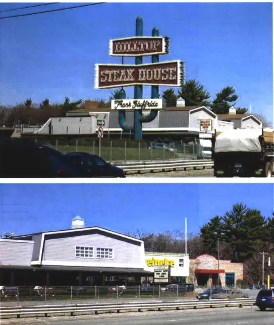
stores, and diners. Most of Route 1 Saugus' most famous landmarks were built in the 1 960s and 70s, including the Hilltop Steakhouse's fifty foot cactus.6
Saugus, like Dedham, is run with a town meeting
structure. The Saugus five-member Board of Selectmen, for approving all permits and special
permits, for selecting the town manager, and for appointing members to town boards and committees
Figure 3: "Landmark's Decisions" cartoon charicature's Sau-gus Route 1 icons. (Source: Gathering Memories).
including the planning board and zoning board of
appeals. The board members are elected for two-year terms in general town-wide elections. The Saugus town meeting is comprised of fifty elected members, and is responsible for approving all town budgets, and drafting and adopting policy and legislative changes, including changes to the
zoning by-law. The town has periodically hired a director of community development, but does not currently keep a planner on staff.
Peabody: Peabody's early settlement history
parallels that of Saugus. It was officially
incorporated as a town in 1866, under the name of
South Danvers. In 1868, South Danvers changed its name to Peabody, and became a city. Due to its prime location along three prominent rivers, Peabody soon became a regional manufacturing center, producing glassworks, pottery, cotton, wool and glue; the main industry was leather, endowing Peabody with the nickname, leather city.7
While Route 1 Peabody shares its history with Route
1 Saugus, one primary difference distinguishes
the two to this day. Several mobile home parks in Peabody located along Route 1 during the
mid-twentieth century. By the time the city wrote its first zoning code in the 1 950s, the parks were well-established uses, and have been both permitted
uses and vocal constituencies ever since.
Because Peabody is a city, rather than a town, its
governmental structure is different than in Dedham
and Saugus. The city is run by an elected eleven-member City Council that has legislative decision-making power, including adopting any changes
to the zoning by-law. Peabody City Council also
selects the nine-member planning board and the
five-member zoning board of appeals; the planning
board oversees the subdivision of land, and the
zoning board oversees applications for variances
and special permits, but ultimately both serve only
advisory positions to the city council. The City also
has a community development department with
a full-time staff including four full-time planners.
The Department oversees the maintenance of the master plan, drafts zoning changes, and oversees housing development.
While the path of Route 1 has been etched through all of the case study towns for almost as long as the towns have been incorporated, their strips were developed long after the towns' centers. For the most part the zoning along the strips was written, if not to actively attract the kind of development that
exists there now, then as a suitable envelope for
modern auto-oriented development that the towns hoped would provide stable economic growth. In the late 1 950s, many towns in the Boston metropolitan were experiencing such unprecedented residential
growth that fiscal and infrastructure strains resulted;
these towns often adopted pro-development policies, including converting land from residential
to strip commercial zones along major arterials
such as Route 1 .8 These towns all share this common history and common road, making them
good samples of similar places that have evolved remarkably different strips.
Ill. Research Scope and Limitations
This thesis ties perceived identities of strip districts
to how those strips are governed by zoning code.
The first thing to note is that I only conducted interviews with planners and city officials. There are number of other groups whose interests and perceptions are equally relevant to how towns make decision, including citizens, business owners, and
non-profit groups, that I did not incorporate into the
research for this thesis. Therefore, the argument presented here is restricted to how public sector
officials perceive the identity of strip districts, and
how their perceptions influence the use of zoning code.
This research uncovers a number of correlated
questions that are not within the scope of this argument. Most prominently, as mentioned above, this thesis will not examine the possible roots of the different identities assigned to Route 1 by
each town. While there are qualitative differences between the composition of the towns' planning boards, overall population demographics, planning budgets, and development history, this thesis will focus on the results of the identifications, rather than these potential causes.
Additionally, this thesis is not intended to argue
about the quality of the resulting developments in
the study towns, and therefore, I will spend little
time assessing the developments by any criteria other than how well they respond to the criteria
set out in their respective zoning codes and master plans. Furthermore, because the research is focused
only on the parts of the zoning codes that relate to
Route 1, I cannot make assertions about zoning as
a whole, or about any of the towns' approach to zoning as a whole.
IV. Importance of this Research
This research contributes to an ongoing discussion
about suburban sprawl and suburban strips in particular. This paper uncovers a subtlety about strips and their regulation that is not present in
the current scholarship about strip development. Ideally, this revelation of complexity within
strip environments and the towns in which they
reside will prompt further research into better ways of approaching the reform of existing strip developments.
V. Chapter Summary
Chapter 2: Methodology. Before delving in to the content of the literature review and case study
chapters, this chapter describes how I conducted my research and analysis. The chapter explains the choices I made in terms of how to conduct interviews and who to talk to; how I located additional sources; how I analyzed those sources; and ultimately, the caveats associated with each of my choices.
Chapter 3: Background and Literature Review. This chapter will briefly outline the most important
literature regarding suburban strips, zoning, and
the perceived identity of place. The review focuses on New Urbanist literature that typically argues
that suburban strips are essentially built out representations of bad zoning. This chapter sets
up the discussion in Chapters 3 and 4, that seek to
find a subtlety in the relationship between zoning,
town and strip that is not addressed within the New Urbanist dialogue.
Chapter4: Existing Conditions and Zoning.Chapter 4 lays the foundation for Chapter 4 by illustrating that, contrary to the New Urbanist position, there is significant variation in physical and regulatory environments between the studied strips. I take
the reader on a tour of the existing conditions of Route 1 in Dedham, Saugus and Peabody and then
outline the relevant zoning by-law in each of the
towns. I then compare how well the code predicts the build out in each town. I conclude the chapter
by exploring some of the reasons for the variation
that stem from the dimensional requirements and
the manners in which the towns enforce those
requirements.
Chapter 5: The Role of Perceived Identity. The preceding discussion leads to the final step in answering the question of this thesis. Is the variation revealed in Chapter 4 related to the way that these
communities perceive their strip? Chapter 5 probes
the relationship between the perceptions of public
officials and how the towns use zoning in their strip districts. The chapter argues that in each of the
case study towns, the ways in which public officials view their strip influences the decisions they make
Chapter 2: Methodology
1. Introduction
In order to answer the question of whether and
how perceived identity of strip districts effects how
strips are regulated, I broke my research into two distinct sections of questioning and analysis. The first phase, encapsulated in Chapter 4, establishes that these three strips differ from one another both
in built landscape and in how they are regulated
by their respective towns. I use photographs
to illustrate the current conditions of the three commercial strips. In order to understand how the strips are regulated, I relied primarily on the most recent version of each town's zoning code; I focused on the dimensional and use requirements
that govern highway development areas, and the implementation measures that the code provides for those districts. I gathered information from
interviews with local officials, planning board members, and planners in each town.
The second phase is a deeper analysis of the way Route 1 and its accompanying development is
perceived by the towns it passes through, and how
that perception has influenced each town's decisions about regulating the roadside. This portion of the investigation involved establishing a connection
between how town officials view their strips and the
variation in zoning approaches explored in Phase 2.
Because the nature of my thesis question is complex and qualitative, I relied primarily on three sources
of information in order to bolster my findings from
any given source. The three sources are interviews,
published planning documents, and local and
regional press coverage. Each source provided its own benefits and challenges. Below, I will discuss in depth how I selected and analyzed my sources
for the first and second phases of my research.
1I. Phase
1
in order to make a compelling case for real variation between strip districts for Phase 1, I relied primarily
on an examination of actual zoning by-law and on my own observation of the physical strip environments
in each town.
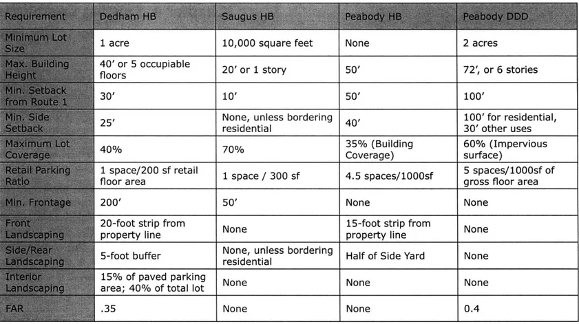
Zoning By-Law: I relied on the most recent version of each town's zoning by law in order to illustrate
the regulatory differences from town to town. In
order to make the most effective and concise
case, I decided to only do detailed comparisons of
dimensional requirements in the zoning districts abutting Route 1. A table illustrating the comparison is included in Chapter 4. Not only was it important to illustrate the differences in how much each town's zoning attempts to regulate, it was also important to illustrate that they way each town's enforcement differs. Therefore I relied on the text of the by-law, and the expertise of my interview
subjects (discussed further below) to gather an
understanding of each town's site plan and design
review processes.
Observation: After establishing that each town has a very different regulatory framework for its stretch of strip, I wanted to illustrate that these approaches
lead to very different outcomes in physical build
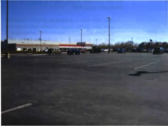
out. To do this, I drove up and down Route 1 through each town, photographing various site conditions, building orientation, landscaping, and parking features. A selection of these photographs
accompanies the description of each town's strip in Chapter 4.
Ill. Phase 2
Developing a sense for each town's officials' perceptions of Route 1 and connecting those
perceptions to how each town uses strip zoning was a more complicated task than researching for Phase
1. I relied on three basic sources for information:
personal interviews, planning documents, local press.
A. Interviews
Identifying and contacting interviewees: The most informative and important source for this research were the interviews I conducted. Due to
time constraints and the scale of this project, I
elected to focus my research on the perceptions of local planners and officials, rather than on a wider cross-section of individuals involved in decision-making along Route 1. My initial goal was to
interview several individuals from each town, and to try and interview people in the same position
in each town. I identified twenty people over the three case-study cities and towns; this list included
planning board and zoning board of appeals
members, town-meeting members, city councilmen, selectmen, staff and planners. I contacted all twenty
individuals, and ultimately interviewed eleven town
planners, representatives, and officials, during a
total of fourteen interviews. Although the response
rate was not ideal, supporting information from my
other sources (discussed below) helped to reinforce
triangulation was most important in Peabody, where
I was only able to interview two city planners.
Interview method and structure: I elected to use
a free-form interview technique for several reasons. I wanted to develop an understanding of how the
interview subjects perceived Route 1 in their own
language, to understand their individual priorities, and to get a sense of their individual relationship to the road. Therefore it was important that the interviewees responded to open-ended questions. Because many of the individuals I interviewed are part-time employees, volunteers, or elected
officials, I felt that I would achieve better response
rate through direct contact and conversation, rather than a written survey with open ended questions
that could be more time consuming than an oral interview.
Initially, I developed a central set of questions that I intended to ask each interview subject.
However, after conducting the first two interviews,
it was clear that once I had described my topic and question, many subjects would talk about what they felt comfortable talking about, regardless of
the questions I asked. As most subjects felt more
comfortable in a conversational setting rather than a structured setting, I shifted to a more free-form interview structure. Therefore, while I still attempted
to cover my central questions in each interview, there was a large degree of variation in the material and topics covered interview to interview.
Because of the informal structure of my interview method, I elected to take notes from each interview, rather than recording or transcribing them. This allowed me to engage more openly in conversation
with my interview subjects. I took notes during the
interviews, documenting the questions I asked that were not initially part of my central set of questions, and taking notes on all of their answers. When a
subject made a comment that was particularly salient, I transcribed it directly.
Analyzing findings: I conducted interviews both over the phone and in person. I took notes by hand, in order to maximize the conversational nature of the interaction. After each interview, I typed my notes from the interview, and began to catalogue the responses of each subject according to the central themes I discuss in the body of this thesis.
I probed the results of each interview to determine
each individual's priorities forRoute 1, and then each
individual's perception of: the role of Route 1 in the community; the role of zoning in shaping Route 1 development; the role of zoning implementation in
shaping Route 1 development; and the connection between the perceived role/identity of Route 1 and the town's approach to strip zoning. In some cases these questions were explicitly answered by the
interview subjects, and in other cases, the subject
discussed these questions in the context of specific developments, or in response to other questions. (For a summary matrix of all interviews, please see
Appendix B.)
Strengths/weaknesses of method: This free-form, open-ended question interview method allowed me to derive the vocabulary for my thesis from what I learned in the interviews, rather than imposing my own framework on each interview subject. However, this process also heightened the degree of subjectivity necessary in analyzing and comparing the content of the interviews.
B. Planning Documents
Gathering sources: In terms of planning documents,
I relied on published plans and analysis documents
from each of the three cities and towns. All three case study municipalities had recent planning documents that I was able to analyze.
Analyzing findings: I used a similar method for
analyzing planning documents as I used for the interviews. I read the documents in the interest of determining: the overall focus of each document on the Route 1 area; the expressed or implied attitude or perception about the identity of Route 1 in the town; and how the documents address (or did not address) zoning on Route 1. (A summary matrix of these documents can be viewed in Appendix B).
Strengths/limitations of source: The primary limitation of the documents is that they tell a very specific story about the values of its authors, but not necessarily about the values of town as whole. However, because this research is primarily focused on the perceptions and views of town officials and
planners, planning documents are a good, stable source for information about the attitudes of this group.
C. Local and Regional Press
Gathering sources: In order to gather a sample of articles, I first conducted broad searches through
periodical archives. These searches returned a
broad spectrum of articles pertaining to Route 1 in each case study town, but ultimately did not provide a bulk of relevant articles.
After these initial searches, I conducted searches through press clippings files in local libraries and planning office archives and I also received a number of clippings from my interview subjects. My access to press sources was limited by the resources of the town. Dedham and Saugus Libraries both maintain extensive clippings files, and planners and officials in both towns maintain their own archives which they generously shared. In Peabody, however, neither the library nor the planning office maintains a clippings file, thus limiting my access to local press resources in Peabody.
Analyzing findings: The press sources tended to provide supporting and background information rather than central evidence for my arguments. Nevertheless, I used a similar method for analyzing the press sources as I used for the planning
documents and interviews. I categorized the
or editorial articles, and then in both cases assessed what the expressed or implied attitude about Route
1 was; whether or not the articles shed light on the relationship between the presented attitudes and zoning; and ultimately whose attitudes, opinions,
or perceptions were being expressed. (Please see
Appendix B for a summary of my findings from
press sources).
Strength/limitations of sources: Exploring local
and regional press coverage of Route 1 in Dedham, Saugus and Peabody provided me with some background insights into both how Route 1 is perceived within each town, and how it is perceived
by outsiders. In addition, many of the articles
that I came across contained quotes and stories about officials and planners who I was not able to interview directly. While these sources could not
provide the same level of certainty about content
as a direct interview, they did provide additional
insight, and access to stories that did not surface in other sources. However, because I did not locate
an exhaustive group of all articles on Route 1 for each town, I cannot say the articles I found are representative of all articles. Also, it is possible
that the articles I gathered from individuals' collections were biased in support of the view of
the individual. Nevertheless, the articles were an
important resource for understanding context
and background. In most cases they served to
bolster my analysis from interviews and planning
documents, and therefore served to deepen both my understanding of the range of issues at hand,
and my research overall.
IV. Conclusion
Once I had catalogued the content of the interviews,
documents, and articles, distinct trends emerged within each town. These trends comprise the
thematic content of the case studies presented in
Chapters 4 and 5, and form the basis of my thesis
argument. In drafting the case study stories, I
selected representative quotes from each of my source bodies to illustrate these trends.
Chapter 3: Background and Literature Review
U.S. Highway 1 is in fact one of the most sensationally ugly roads in America... JBJackson, Landscape in Sight'0
1. Introduction
Early fascination with the strip was evidenced in the writings of critics, architects, and designers. As stated byJB Jackson, the strip's
"potentialities for trouble - esthetic, social,
economic - are as great as its potentialities
for good, and indeed it is this ambidexterity
which gives the highway and its margins so much significance and fascination. But how are we to tame this force unless we understand it and even develop a kind of love for it? And I do not believe that we have really tried to understand it as yet. For one
thing, we know little or nothing about how
the roadside development, the strip, came
into being, nor about how it grows."9
These questions that Jackson poses in 1958 have rarely been addressed head on by other writers in the half century since. In fact, much of what puzzled Jackson about the contradictions and mystery of
the strip still eludes even the brightest planners. While there is little literature specifically about
zoning in commercial strip districts and none about
perceived identity and zoning, there are significant bodies ofwork devoted to understanding the physical and formal effects of various kinds of regulation in suburban areas, the design of commercial strips, and how issues like perception can influence
policy-making. The following chapter will survey the three
significant strains of literature that contribute to an ongoing discussion, started by authors like Jackson
to carve a niche for the central argument of this thesis.
II. The Suburban Strip
Recent books by Grady Clay and Dolores Hayden,
following in the exploratory tradition of JB Jackson, have sought to find the right language and
Figure 1 (Above): An "Edge Node" (Source: Jim Wark photo from A Field Guide to Sprawl); Figure 2: Image of the Vegas Strip (Source: Learning from Las Vegas).
and how important it is to develop better ways keep up with it.
Thirty years ago, Robert Venturi, Denise Scott Brown
and JB Jackson first began to critically examine the nature of the highway strip. Learning From Las
Vegas is the first real attempt to understand the strip on its own terms. Venturi and Brown distill from the Las Vegas strip a vocabulary of commerce, attraction, competition, and a unique logic. Within this "architecture of persuasion" a co-dependent relationship between the highway and the strip development is conceived and cemented."
JB Jackson picks up on the questions that Venturi
and Brown raise. In an attempt to explain the
growing incoherence and questionable taste of
much highway development, Jackson proposes the
following:
"At present the average highway resort -motel, drive-in movie, restaurant, ornightclub
- has been put up by the owner with no sort of guidance but his own limited experience
and taste, or at best by a building contractor. The display signs are usually the product of an industrial firm knowing nothing of the
location of the public... The landscaping is done by the local nurseryman, and the planning, the location, the relationship to
the neighbors and to the highway is little more than an adjustment to local zoning
department. We need not be astonished at
the results."12
In this early critique, Jackson makes the first
stab at strip zoning. The attitude encompassed in this passing comment by one of the first true observers of the strip is echoed again and again
in more recent criticism. Many authors argue that
the landscapes photographed in Hayden's book are
literally built out versions of bad zoning, and that to
stop the proliferation of such unfortunate design, we must abandon zoning as a regulatory tool. This
suggestion, as previously noted, is based on the assumption that strip development and regulation is a singular, uncomplicated phenomenon. The following section examines the literature about
strip zoning in order to highlight these trends.
Ill. Strip Zoning
By the late 1 960s, planning textbooks had identified
the shortfalls of zoning as a comprehensive
planning tool, noting for example that zoning
was not suited towards creating aesthetically
pleasing environments. An interesting source
for professional attitudes about zoning as a tool is planning text book chapters written at a time
when the urban renewal movements of the 1950s had shed some doubt on the efficacy of centralized
planning efforts.
One central 1968 book, Principals and Practice
of Urban Planning, provides good insight into the
critical thinking about zoning during the 1 960s.
As a starting point in his "Zoning" chapter, Robert
M. Leary begins by recognizing the confusion
between "planning" and "zoning." In the early days
of comprehensive planning efforts, many towns simply created zoning maps and expected that to
be enough to ensure healthy future growth. Leary
identifies three main concerns about how this tendency to replace planning with zoning would influence development patterns in the future:
"1. There will be a tendency for development
to be frozen in the existing pattern; 2. Wholly
unexpected results may be produced, frequently of
a very undesirable nature; 3. The ordinance may
require amendment to such an extent, on behalf of
individual property owners, that no comprehensive
pattern of development in the city can result."13 This prescient argument provides a useful grounding for understanding what has happened to some degree
in all three case studies examined later.
In large part, the use of zoning in lieu of planning
has been attributed to the federal Standard City Planning Enabling Act of 1928 which led to most state enabling acts. The "Act left many planners and public officials confused about the difference between a master plan and a zoning ordinance, so that hundreds of communities adopted 'zoning plans' without having created comprehensive
plans as the basis for zoning."" It was not until
1954, with the passage of the Housing Act that the federal government began to require local
governments to develop comprehensive plans
in order to be eligible for various pots of federal money." This lag between enabling zoning and
encouraging comprehensive planning is at least in
part responsible for the lack of vision and direction in many early zoning codes.
More interesting than Leary's assessment about the dangers of replacing planning with zoning, is
his evaluation of the "deficiencies" found in many
municipalities' original zoning codes. While Leary
notes that the initial ranking of uses as higher and lower (single family being the highest use, to be protected from all lower uses) was no longer
predominant at the time he wrote the article,
his deficiency-list shows a distinct bias toward
completely segregated use areas. For instance:
"7. Non-conforming uses [in residential areas] are
regulated in a manner that tends to perpetuate them rather than lead to their eventual elimination;" or "9. Some commercial uses such as gas stations
or funeral homes are allowed in residential districts;" and finally, "15. Neighborhood business district regulations are not designed to minimize
any adverse effects of business use upon abutting
residential areas."16
At the same time as demonstrating a concern for the purity of the residential enclave, Leary does suggest that some mixed uses make sense given the proper circumstances. For instance if industry does not produce negative effects such as smoke,
dust, noise, unattractive areas, there is no reason that residences cannot exist nearby. Similarly, if
enough parking is provided, then there is no reason that neighborhood shops and residences cannot exist side by side, or one on top of the other.17
Leary's article was written in 1968, around the same
time that the zoning codes for the three case study
towns addressed in this paper were either written or revised. The slight inconsistencies, such as mixed messages about segregating uses, visible within his discussion were largely accepted by planners in his day - explaining much of the peculiarity we will see later in examining this old code.
Although much of his thinking appears a bit dated,
Leary is one of the few authors, of his time or ours, who deals comprehensively with zoning in both
residential and commercial areas. According to
Leary, the biggest problem regarding commercial
zoning at the time of his article was the allotment of too much space for commercial zones. He
argues that this phenomenon tended to cause slums and abandoned properties when property owners converted residences to commercial spaces
expecting higher returns only to find no market for their new spaces. Leary argues that this practice
led to undervalued properties that attracted little or no attention, since once converted to commercial,
they couldn't be converted back into residential.8
While Leary indicates significant concern about the placement and concentration of commercial
facilities, however, he shows no concern about
the physical layout of such centers.19 At this point
in the larger conversation about the efficacy or
of how zoning could be used as a tool to control
the appearance, organization, or function of a commercial area.
In "Zoning," a similar article to Leary's but published
in 1978, Frank S. So reiterates many of the same concerns and trends. He too makes a half-hearted
argument that the hierarchy of zoned uses has
broken down, suggesting that "zones are now
mutually exclusive - residences can generally no longer be built in commercial or industrial areas
because they can potentially cause (economic) harm to factories or warehouses." 20 Despite the lapse of
time, however, So reiterates Leary's concern about
underused commercial spaces to note that "No one,
by the way, has solved the bugaboo of many cities
-the old linear or strip commercial area, that remnant
of the age of the streetcar, which is deteriorating
"121 hi
and is packed with vacancies. In his article, So
discusses strips in more urban locations than the
strips discussed in this thesis, but nevertheless
his suggestion that no one has yet developed a
zoning strategy to help reform commercial strip development is still relevant.
This concern about the adaptability or reformability
of strip development has been picked up by contemporary critics of the suburban environment
and channeled into a more precise attack on the
underlying concept of use-segregation. Alex Krieger argues in his "Since (and Before) Seaside" in Duany and Plater-Zyberk's Towns and
Town-Making Principals, that in addition to a cultural
tendency to spread outward and a deep love of the automobile, planning regulation - namely zoning
and legislation like the 1 960s Federal New Town Program - promotes suburban sprawl. He states
quite directly that "our planning tools - notably our zoning ordinances - facilitate segmented, decentralized suburban growth while actually
making it impossible to incorporate qualities thatwe associate with" picturesque New England towns.22 This argument, while quite accurate in many ways, establishes a trend of discussing suburban zoning
as a uniform force in shaping development from
place to place.
In the past decade, several other well-known authors and planners have sharpened and expanded Krieger's criticism of suburban land use regulation and growth policies to create a
conceptual basis for new urbanism. Much has been written about suburban residential development
and suburban office development to draw attention
to specific design consequences of standard land
use regulations. Michael Southworth and Eran
Ben-Joseph's 1995 article "Street Standards and the Shaping of Suburbia" draws a clear, empirical
connection between the typical street standards promulgated by federal mortgage insurance
policy and by industry publications. The article highlights street standards created for developers taking advantage of FHA mortgage insurance. The
standards included a standard eighty-foot right of way that provided room for the street to expand
as the neighborhood grew. These standards
were adopted by nearly all subdivision developers
sought to comply in order to be assured mortgage
insurance.23 The FHA standards became the model for most local subdivision control regulation resulting in practically whole sale buy-in to the federally developed standards. Southworth and Ben-Joseph argue that "the rigid framework of
current street standards has resulted in uniform,
unresponsive suburban environments."2
In a similar article, Richard Willson uses a series of
case studies to argue that "parking policy is a key element of the context for travel choices and urban
form."2
s The typical parking ratio is four spaces
per thousand square feet of office space - this ratio
is derived from industry publications like the ULI Office Development Handbook. However, a series of
studies conducted through the mid- to late-1 980s
indicated that most office developments show peak
demand levels of between two and three spaces per
thousand square feet. The result is: "there is a lot of unused parking in the suburbs."26
The case studies surveyed in Willson's article all showed peak parking usage well below the amount
of parking supplied. Willson's main point is an
economic argument that because"... parking typically was oversupplied and provided at no direct cost to tenants or their employees" there is no incentive to seek alternate means of transportation.27 However, his study clearly establishes that "when ajurisdiction adopts high parking requirements, it is enacting
a form of growth control,"2" that encourages low
density development, but is not clearly addressed
in policy debates about growth control or urban design. This article comes closer than any of the preceding to establishing an empirical connection between written zoning code, and its physical outcome.
Much of this literature, while focusing on suburban
residential and office development, has ignored the
commercial strip. James Howard Kunstler, author
of the much-publicized and oft-quoted Geography
of Nowhere, wrote a subsequent book called Home
from Nowhere - a more technical analysis of the
roots and consequences of American suburban
form - including the strip. The basic thrust of
Home from Nowhere is that zoning is responsible for all bad suburbs:
"If you want to make your community better, begin at once by throwing out your zoning laws.. .the place that results from zoning is suburban sprawl. It must be
understood as the product of a particular
set of instructions. Its chief characteristics are the strict separation of human activities (or uses), mandatory driving to get from one use to another, and huge supplies of free
parking."29
In fact, not only does zoning result in un-sensibly
segregated uses,
zoning is a formless, soulless, centerless, demoralizing mess. It bankrupts families and townships. It causes mental illness. It disables whole classes of decent, normal
citizens. It ruins the air we breathe. It corrupts and deadens our spirits."30
Kunstler takes the discussion of the ills of zoning
regulation, the empirical exploration by Southworth,
Ben Joseph, and Willson and brings it to bear on
commercial strip areas. But the argument is
essentially the same - requirements for setbacks
and scale render the strip into an "anti-place."31 He suggests that most strip-mall locations are simply
built out expressions of code requirements, and
he notes that strip use segregation magnifies their design quandaries, because no other typology is allowed to co-exist there.
While he is one of the few authors to take on both
residential and commercial districts, as well as both
use and dimensional requirements, Kunstler says
little about what should be done with our existing environments. He has latched on the new urbanism
cannon, without providing ideas for how small towns with few resources for planning can adapt
their existing physical and regulatory landscape to
be something better than what it is. His position is
almost so hopeless, that it is hard to imagine that anything short of leveling much of the American
landscape and starting from scratch would be enough to make it better. Nevertheless, Kunstler has become a central figure in the emerging consensus
that zoning is largely responsible for the physical form of contemporary suburban development.
And, like Krieger, Kunstler presents the strip and
strip zoning without the subtlety encapsulated in
actual places and zoning codes.
Despite the call to abandon zoning, much of the New Urbanist system is still dependent on very stringent
regulation. The next step, "transect planning," is a
model devoted to eliminating traditional Euclidean
zoning altogether. Andr6s Duany and Emily Talen's
2002 article, "Transect Planning," outlines their new
concept. Building on the work of Ian McHarg in Design with Nature, transect planning applies the framework of ecozones to the town plan. Instead of creating districts based on uses, the transect
plan makes use of "form-based codes" that create zones based on dimensional requirements that
facilitate certain uses and activities, and plans for a continuum of densities that can accommodate all
uses. The transect town begins with an urban core at its center that is characterized by the highest
densities and radiates outwards with decreasing densities until it reaches rural preserves and
reserves.33
Transect planning is based on the omnipresent
presumption in this literature that the cause of
sprawl is Euclidean zoning, and that by moving away from uniform use district zoning, the problem of sprawl can be solved. While transect
planning presents an interesting alternative for
new greenfield development, it does not address
the existing variation and zoning subtleties within existing suburban areas, and does not present a viable way to make existing places greener or more efficient. 4
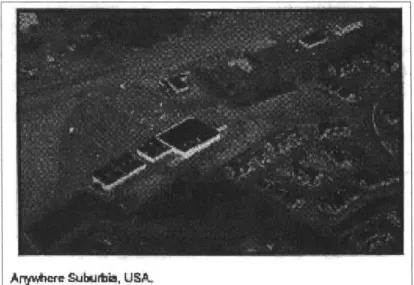
Not everyone buys the Duany model however. Tony Nelessen's work with visual preference surveys has
provided alternative model to complete zoning
code overhauls. Nelessen uses visual preference surveys to identify community preferences for the style and form of new developments. Nelessen begins to tap into the place identities that
individuals perceive in places they like and dislike.
He uses the preferences that derive from those
perceptions, to help communities convert their existing zoning into code that encourages more favorable development. Nelessen's work begins to
Arywher Suburtb, US&
Figure 3: "Anywhere Suburbia, USA" Even Nelessen treats
sprawl as a uniform, identity-less phenomenon. (Source: Vi-sions for a New American Dream.)
forge a connection between an understanding of zoning and an understanding of the way that people
perceive and identify real places. The final section
of this chapter will explore this connection between
perceived identity and place regulation in the work
of Nelessen and others.
IV. The Perceived Identity of Place
In his book, Visions for a New American Dream,
Nelessen critiques suburban sprawl and proposes
a new way to plan for denser, pedestrian-oriented,
more traditional suburban towns. While Nelessen,
like most other authors on suburbia, treats suburban
sprawl, particularly suburban strip development as a
uniform environment, his trademarked approached to planning begins to unveil the importance of local communities perceptions about place, and makes
the link between how those perceptions can be captured to change zoning strategies (see Figure 3). Nelessen uses a survey in which respondents rate images of a variety of places based on what they
like best. Visions reports that typically the images showing traditional neighborhoods and town
centers receive the highest ratings, and arterial road bordered by strip malls typically receive the lowest
rating. Nelessen then argues that by comparing what a community's zoning code actually would allow to the images that people found most appealing can help catalyze zoning changes that favor denser more traditional development."
perception and regulation that, unlike Duany's transect planning, can be tailored to individual
places and circumstances.36 However, he is in
the business of shaping preferences and actively
working to use them to manipulate local zoning
codes. Other strains of literature have worked to
highlight more closely the concepts of place identity
and perceived identity and how these perceptions shape policy. The social science literature about place identity defines the term similarly to the way
I have defined perceived identity for this thesis: the
connection between the image of physical setting
and an individual's identity.37 While this thesis looks at the connection between the image of physical setting and a town's identity, looking at place identity provides informative background, as
ultimately even when looking at a town's identity, it is individuals perceiving that identity and making
decision about how to shape it.
Dolores Hayden's Power of Place; Urban Landscapes
as Public History, a work that explores this question of place identity, advocates for intensified scholarship to uncover socially inclusive landscape histories because unless people feel that a place is linked with their personal or cultural identity, it will
be difficult to motivate them to preserve historic
development. Rather than working to figure out
how to harness people's perceptions of place as Nelessen does, Power of Place highlights the historic
connection between perceived place identity and
action.
Like Hayden's work, several environmental
psychologists have picked up on the connection
between place identity and policy action. Misse Webster-Herber's "Underlying Concerns in
Land-Use Conflicts - The Role of Place-Identity in Risk
Perception," links place identity to risk perception
to illustrate that the level of an individual's aversion to certain land uses will be strongly rooted in how closely they identify with the place that they live.38
The work of Hayden, Nelessen, and Webster-Herber makes concrete steps towards connecting the way people perceive place to the decisions people make
about regulating place.
V. Conclusion
Not all authors and practitioners have taken the approach that all of suburban development is homogenous. In Building Suburbia, yet another
groundbreaking book about the American suburbs,
Dolores Hayden
"highlights the complex relationships
between real estate entrepreneurs and a wide range of suburban residents and workers... [and] explores the interplay of the natural and
built environments, considers women's and children's lives as well as men's, discusses working-class houses and yards as well as
"139
affluent ones...
Hayden convinces her readers that there are many
suburbias. While championing this rare notion
of diversity of suburbia, Hayden focuses almost exclusively on residential developments. Even the
early work of Venturi and Brown, JB Jackson, and others treats suburbia, and the strip in particular as
a singular landscape that is replicated throughout
North America. Hayden's vision of multiple histories and subtlety where others see only endless "seas
of parking" has not yet filtered into the common understanding of strip commercial development.
New Urbanist literature has come closest to
developing an understanding of the forces that
shape the commercial strip. The New Urbanist
writers, however, have concluded - based on an assumption that suburban strip development is simple and homogeneous - that zoning is ultimately
and uniformly to blame for the physical form of
most suburban development. Even while they
channel early warnings from planners like Leary,
they treat zoning like an independent force that has
the power to form landscapes on its own. Because
of this, the New Urbanist writers have suggested that until municipalities hang their zoning out to dry
and adopt a new method of regulation, either form-based codes, or transect planning, or something
not yet thought of, then our cities and suburbs
are at the mercy of long-outdated zoning codes,
written by misguided planners twenty, thirty, even
fifty years ago.
Nelessen, Hayden, and Webster-Herber, though
writing in many different fields, argue that the way
people feel and think about places ultimately has an
impact in how they make decisions about regulating
those places. The following chapters represent an
attempt to illustrate that each suburban strip is
unique; while zoning can have predictable results in given situations, each town's strip zoning is a
product of many considerations, including the community's perception of what its strip is and what it could be. Ultimately, these perceived identities
represent a driving force that has a measurable
impact on how towns use zoning as a regulatory tool to shape development in their strip districts.