HAL Id: tel-01271644
https://tel.archives-ouvertes.fr/tel-01271644
Submitted on 9 Feb 2016HAL is a multi-disciplinary open access archive for the deposit and dissemination of sci-entific research documents, whether they are pub-lished or not. The documents may come from teaching and research institutions in France or
L’archive ouverte pluridisciplinaire HAL, est destinée au dépôt et à la diffusion de documents scientifiques de niveau recherche, publiés ou non, émanant des établissements d’enseignement et de recherche français ou étrangers, des laboratoires
Cooperative Mobile Robots Optimal Mapping and
Navigation
Daji Tian
To cite this version:
Daji Tian. Cooperative Mobile Robots Optimal Mapping and Navigation. Automatic. Ecole Centrale de Lille, 2014. English. �NNT : 2014ECLI0016�. �tel-01271644�
No
d’ordre : 2 5 6
´
ECOLE CENTRALE DE LILLE
TH`ESE
pr´esent´ee en vue d’obtenir le grade de
DOCTEUR
Sp´ecialit´e : Automatique, g´enie informatique, traitement du signal et des images par
TIAN Daji
Master of Engineering of Beijing University of Aeronautics and Astronautics (BUAA) Doctorat d´elivr´e par l’´Ecole Centrale de Lille
Optimisation de la Cartographie et de la Navigation des Robots Mobiles Coop´eratifs
Soutenue le 18 d´ecembre 2014 devant le jury :
M. Pierre BORNE Ecole Centrale de Lille Pr´esident
M. Noureddine ELLOUZE Ecole Nationale d’Ing´enieurs de Tunis Rapporteur M. Dumitru POPESCU Universit´e Polytechnique de Bucarest Rapporteur
M. Abdelkader EL KAMEL Ecole Centrale de Lille Directeur de Th`ese
M. Olivier COLOT Universit´e de Lille 1 Examinateur
Mme. Shaoping WANG Beihang University, Chine Examinateur
Serial No
: 2 5 6
ECOLE CENTRALE DE LILLE
THESIS
Presented to obtain the degree of
DOCTOR
Topic : Automatic control, computer engineering, signal and image processing by
TIAN Daji
Master of Engineering of Beijing University of Aeronautics and Astronautics (BUAA) Ph.D. awarded by Ecole Centrale de Lille
Cooperative Mobile Robots Optimal Mapping and Navigation
Defended on December 18, 2014 in presence of the committee :
M. Pierre BORNE Ecole Centrale de Lille President
M. Noureddine ELLOUZE Ecole Nationale d’Ing´enieurs de Tunis Rapporteur M. Dumitru POPESCU Universit´e Polytechnique de Bucarest Rapporteur
M. Abdelkader EL KAMEL Ecole Centrale de Lille Directeur de Th`ese
M. Olivier COLOT Universit´e de Lille 1 Examinateur
Ms. Shaoping WANG Beihang University, Chine Examinateur
Th`ese pr´epar´ee au Laboratoire d’Automatique, G´enie Informatique et Signal L.A.G.I.S. - UMR 8219 - ´Ecole Centrale de Lille
´
I dedicate my dissertation work to my family. A special feeling of gratitude to my loving parents, TIAN Jinshun and ZHANG Yingchao whose words
of encouragement and push for tenacity always ring in my ears.
I dedicate this work and give special thanks to my wonderful girlfriend LIU Lingshan for being there for me throughout the last two years of the
doctorate program, and being very helpful and comforting. You have been my best cheerleader.
I also dedicate this dissertation to my many friends and workmates who have supported me throughout the process.
I will always appreciate all they have done, especially ZHENG Tian and YU Yue for helping me to develop my technical skills, XIA Chen for many
academical communications during the process, and LIU Bing, SUN Qi, LIU Yihan as helpful workmates and best friends in my life.
At last, great thanks for everyone who supported me and are supporting me and will support me forever!
Acknowledgements
The PhD work presented in this thesis has been realized in Ecole Centrale de Lille, at ”Laboratoire d’Automatique, G´enie Informatique et Signal” (LAGIS), from September 2011 to December 2014. I am extremely grateful to China Scholarship Council (CSC) who financed this work.
First and foremost I offer my sincerest gratitude to my PhD supervisor, Prof. Abdelkader EL KAMEL, for his continuous support of my PhD study and research, for his patience, motivation, enthusiasm, and immense knowl-edge. His guidance helped me in all the time of research and writing of this thesis. I could not have imagined having a better tutor and mentor for my PhD study. He has provided his supervision, valuable guidance, continuous encouragement as well as given me extraordinary experiences through out the work. A special acknowledgement should be shown to Prof. Shaop-ing WANG, who always supported my thesis work durShaop-ing these three yeas with her helpful suggestions and discussions. My thanks to both Prof. EL KAMEL and Prof. WANG for having involved me in their research coop-eration project and giving me this opportunity to study in France.
Besides my supervisor, I would like to thank Prof. Pierre BORNE for his kind acceptance to be the president of my PhD Committee, as well as Prof. Noureddine ELLOUZE and Prof. Dumitru POPESCU, who have kindly accepted the invitation to be reviewers of my PhD thesis, for their encouragement, insightful comments and hard questions. My gratitude to Prof. Olivier COLOT, for being the examiner of my thesis and for their kind acceptance to take part in the jury of the PhD defense.
FLEURY, Christine YVOZ, and Brigitte FONCEZ have helped me in the administrative work. Many thanks go also to Patrick GALLAIS, Gilles MARGUERITE, Jacques LASUE, for their kind help and hospitality. Spe-cial thanks go to Christine VION, Martine MOUVAUX for their support in my lodgement life at the dormitory ”De Vinci”.
My sincere thanks also goes to Dr. ZHENG Tian and Dr. YU Yue, for offering me the useful advices during my study in the laboratory as well as after their return to China.
I would like to take the opportunity to express my gratitude and to thank my fellow workmates in LAGIS: XIA Chen, LIU Bing, SUN Qi and LIU Yi-han for the stimulating discussions, for the hard teamwork, and for all the fun we have had in the last three years. Also I thank my friends in Beihang University: ZHANG Hongchang, DU Yu, ZHANG Wan. In particular, I am grateful to Prof. WANG Shaoping for enlightening me the first glance of research. They have given me support and encouragement in my thesis work.
Last but not least, I convey special acknowledgement to my family for sup-porting me to pursue this degree and to accept my absence for three years of living abroad: my parents TIAN Jinshun and ZHANG Yingchao, for giving birth to me at the first place and supporting me spiritually throughout my life. So as to my girlfriend LIU Lingshan, without whom I cannot finish my work in time. It is her who has always been supporting me by my side for the last two years. Thanks for everybody!
Abstract
In this Ph.D., we will present firstly an efficient single robot exploration method, then a decentralized cooperative exploration strategy for a team of mobile robots equipped with range finders. A two dimensional map of the explored area is built in the form of a pixel figure. This is expanded by the robots by using a randomized local planner that automatically realizes a decision between information gain and navigation cost. The coverage of the exploration has been defined as the visited area by at least one robot. In our work, the map is reconstructed using a least-mean square method to reduce the errors of the sensor data.
Intelligent control is playing a more and more important role when deal-ing with Autonomous Mobile Robots in unstructured, unknown or partly unknown environments. In dividing the overall task into subtasks, the in-telligent controller allows reducing the robots task complexity. But the fusion of different behaviors with different objectives may cause contradic-tion in the procedure and alter the stability of the system. Therefore, the issue of behavior coordination mechanisms is crucial in order to realize the non-collision safety-ensured movements. A method integrated by behav-ior coordination and command fusion is proposed. A new approach with five basic behaviors, which are respectively Route Following, Target Go-ing, Wall FollowGo-ing, Obstacle Avoiding and Deadlock DisarmGo-ing,for mobile robot navigation are discussed.
Player/Stage is an open-source software project for research into robotics and sensor systems. Its components include the Player network server and the Stage robot platform simulators providing a hardware abstraction layer to several popular robot platforms. Player is one of the most popular robot interfaces in research and post-secondary education. We mainly use
Player/Stage simulation to test our algorithms in mono-agent/multi-agent exploration, map reconstruction and robot navigation. All these results show that the proposed approaches are effective and can be applied in real robots.
Declaration
I herewith declare that I have produced this paper without the prohibited assistance of third parties and without making use of aids other than those specified; notions taken over directly or indirectly from other sources have been identified as such. This paper has not previously been presented in identical or similar form to any other English or foreign examination board. The thesis work was conducted by TIAN Daji under the supervision of Prof. Abdelkader EL KAMEL.
Lille,
Contents
List of Figures xi
List of Tables xv
Abbreviations xvii
1 introduction 1
1.1 Issues of robotic exploration . . . 2
1.2 Motivation . . . 3
1.3 Robot exploration in an unknown environment . . . 4
1.4 Multi-robot approach . . . 4
1.4.1 Advantages . . . 5
1.4.2 Disadvantages . . . 6
1.5 Navigation while new obstacles presented . . . 7
1.6 Contribution . . . 8
1.7 Plan of the thesis . . . 8
2 State of art 11 2.1 Heralds . . . 12
2.2 Assortment by assumption . . . 13
2.2.1 Environment and initialisation . . . 14
2.2.2 Characteristics of the robots . . . 14
2.3 Assortment by objectives . . . 16
2.3.1 Minimisation of the exploration time . . . 16
2.3.2 Minimisation of the energy . . . 16
CONTENTS
2.4 Assortment by identifying area to explore (target) . . . 18
2.4.1 Frontier approaches . . . 19
2.4.2 Next Best View approaches . . . . 19
2.4.3 Utility methods . . . 20
2.4.4 Other approaches . . . 21
2.5 Assortment by assigning targets . . . 22
2.5.1 The nearest frontier . . . 22
2.5.2 Greedy algorithm . . . 23
2.5.3 Greedy on the utility of frontiers . . . 23
2.5.4 Hungarian method . . . 24
2.5.5 Optimal assignment . . . 24
2.6 Assortment by communication mode . . . 25
2.6.1 Without communication . . . 25
2.6.2 Indirect communication . . . 27
2.6.3 Explicit communication . . . 27
2.6.4 Centralised approaches . . . 28
2.7 Conclusion on the state of art . . . 29
3 Robot exploration 31 3.1 Single robot method . . . 32
3.1.1 Frontier-based exploration . . . 32
3.1.2 Frontier detection . . . 33
3.1.3 Navigation to frontiers . . . 34
3.1.4 Recording the explored area . . . 34
3.1.5 Proposed exploration algorithm . . . 35
3.2 Multi-agent approach . . . 36
3.2.1 Problem setting . . . 39
3.2.2 Cost function . . . 41
3.2.3 Computing utilities of frontier cells . . . 43
3.2.4 Target point selection . . . 44
3.2.5 Coordination with limited communication range . . . 45
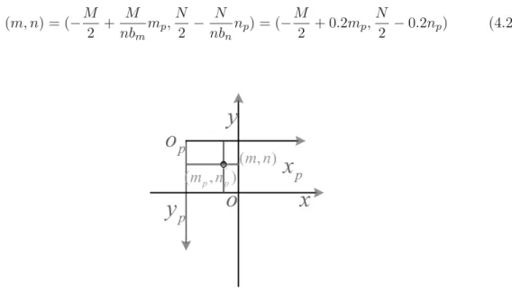
CONTENTS 4 Map reconstruction 47 4.1 Map representation . . . 49 4.1.1 Cell Decomposition . . . 49 4.1.2 Coefficient to choose . . . 49 4.2 Data collection . . . 50 4.2.1 Reference transformation . . . 50 4.2.2 Safety navigation . . . 51
4.3 Map reconstruction algorithm . . . 53
4.4 Conclusion of the map reconstruction . . . 55
5 Robot navigation 57 5.1 The introduction of the five behaviors . . . 58
5.1.1 Route Following (RF) behavior . . . . 59
5.1.2 Target Going (TG) behavior . . . . 60
5.1.3 Wall Following (WF) behavior . . . . 60
5.1.4 Obstacle Avoiding (OA) behavior . . . 61
5.1.5 Deadlock Disarming (DD) behavior . . . . 62
5.2 Implementation of the five behaviors . . . 62
5.2.1 Path planning . . . 62
5.2.2 Wall Following and Obstacle Avoiding . . . 63
5.2.3 How to find a Deadlock . . . 64
5.2.4 How to disarm the deadlock . . . 66
5.3 Behavior coordination and command fusion . . . 67
5.4 conclusion of the robot navigation . . . 68
6 Experimental results 71 6.1 Real robot: Robotino R . . . . 71
6.2 Simulator: Player/Stage . . . 73
6.2.1 Player . . . 73
6.2.2 Stage . . . 75
6.2.3 Simulation model in Player/Stage . . . 76
6.3 Exploration . . . 77
6.3.1 Recorded area . . . 81
CONTENTS 6.4 Navigation . . . 83 6.4.1 Test of behaviors . . . 83 6.4.2 Navigation tests . . . 83 6.5 Performance analysis . . . 86 7 Conclusion 89 7.1 Synthesis of the contribution . . . 89
7.2 Perspectives . . . 90
List of Figures
1.1 Examples of using AMRs to explore hostile environments to humans . . 3
2.1 Local and global strategy (Rekleitis et al.,1997) . . . 18
2.2 Sensor-based random graph exploration in simulation (Franchi et al.,2009) 19
2.3 Evaluation of a candidate position as frontier of exploration target. The visible area outside the explored areas is evaluated by ray radiating from the candidate position (Gonz´alez-Banos and Latombe,2002) . . . 20
2.4 Graph based on the discretization of Voronoi (Gossage et al.,2006). The triangle represents the robot, the squares are the unexplored nodes and disks are explored nodes. The dotted lines show the perception of the robot. . . 21
2.5 Segmentation of the environment with K-means algorithm, with K equal to the number of the robots (Puig et al.,2011). . . 22
2.6 Implicit coordination: three robots leave the explored corridor in the lower part of the figure, and separate in a balanced way before the cross-ing. The frontiers are in red, and the robot are in blue. Each robot goes to its nearest frontier. . . 22
2.7 Illustration of the assignment of the frontiers with the greedy algorithm. The robot-frontier couple are assigned by the order of the cost from the lowest to the highest. . . 23
2.8 Comparison of two ways for robot 1 moving to point a and robot 2 to point b (Burgard et al.,2005) . . . 25
2.9 A proto-typical deployment experiment for a 100-node network (Howard
LIST OF FIGURES
2.10 Example of GPA/GEA construction. Top: The GPA of robot 4 con-sists of robots 1, 3, 4, and 7: robot 1 is still moving toward its target point,while robots 3, 4, and 7 are stationary. The perception areas of the robots (prospective in the case of robot 1) overlap in pairs. Bottom: Once the LSR have been computed, only robots 3, 4, and 7 belong to the GEA of robot 4 since their LSRs overlap in pairs (Franchi et al.,2009). 29
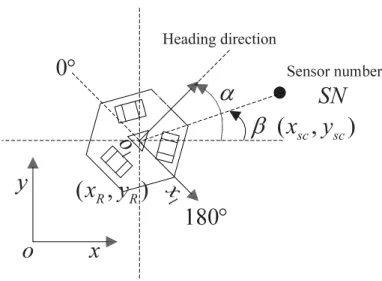
3.1 Schema for the calculation of the sensor number SN . . . 35
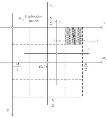
3.2 Reference transformation from the image to the matrix . . . 37
3.3 Obstacle encountering region . . . 38
3.4 Detection zone of minimum distance . . . 39
3.5 Algorithm of exploration . . . 40
3.6 When the robot encounters an obstacle, it will choose a non-visited di-rection to continue its way, but in this situation, we can only choose the green arrow pointed direction . . . 41
3.7 Perception range of the Robotino R in simulation . . . . 42
4.1 Determination of p for cell decomposition . . . 50
4.2 Reference transformation between the image and the real world . . . 51
4.3 Process for the robot navigation . . . 52
5.1 Relationship between the 5 behaviors. . . 59
5.2 Determination of p0 in the simulation. . . 65
5.3 Determination of p0 in experimentation . . . 66
5.4 Passability of the deadlock . . . 67
5.5 Virtual Wall method for deadlock disarming behavior . . . 68
5.6 Vector schema of the 5 behaviors. . . 69
6.1 Robotino R in the laboratory . . . . 72
6.2 Robotino R simulation model . . . . 76
6.3 Map reconstruction using Algorithm I (higher part) . . . 78
6.4 Map reconstruction using our algorithm (higher part) . . . 78
6.5 Map reconstruction using Algorithm I (lower part) . . . 79
6.6 Map reconstruction using our algorithm (lower part) . . . 79
LIST OF FIGURES
6.8 Map reconstruction using our algorithm (central part) . . . 80
6.9 Map reconstruction comparison . . . 81
6.10 Record of the explored area . . . 82
6.11 Three robots exploration in the simulation . . . 83
6.12 Respective reconstruction of the three robots . . . 84
6.13 Map reconstruction from the three robots . . . 85
6.14 Test for the Wall Following behavior . . . 85
6.15 Test for the Deadlock Disarming behavior . . . 86
6.16 Test for the failed navigation(blocked in the unstructured obstacle) from Huq et al.(2006) . . . 86
6.17 Test for the successful navigation . . . 87
6.18 Comparison of the exploration trajectory between the proposed and ex-isting algorithm . . . 87
7.1 Exemples d’utilisation de robots pour l’exploration d’environnements hostiles aux humains . . . 92
7.2 Algorithme d’exploration monorobot . . . 96
7.3 Construction de la carte d’une zone explor´ee . . . 97
List of Tables
5.1 The Combined Membership Function for RF behavior. . . 60
5.2 The Combined Membership Function for TG behavior. . . 60
5.3 The Combined Membership Function for WF behavior. . . 61
5.4 The Combined Membership Function for OA behavior. . . 61
5.5 The Combined Membership Function for DD behavior. . . 62
6.1 The parameters of the Robotino R’s size. . . . 76
6.2 The parameters of the Robotino R’s size in our simulation. . . . 77
6.3 Comparison of the existing algorithm to the proposed algorithms (RT = Real Time) . . . 88
Abbreviations
AMR - Autonomous Mobile Robot AUV - Autonomous Underwater Vehicle GPS - Global Positionning System
1
introduction
Contents
1.1 Issues of robotic exploration . . . 2
1.2 Motivation . . . 3
1.3 Robot exploration in an unknown environment . . . 4
1.4 Multi-robot approach . . . 4
1.4.1 Advantages . . . 5
1.4.2 Disadvantages . . . 6
1.5 Navigation while new obstacles presented . . . 7
1.6 Contribution . . . 8
1.7 Plan of the thesis . . . 8
Exploring an environment has always been a fundamental problem in mobile robotics. It consists, in the most difficult cases, to discover an unknown environment or having been modified during the exploration and build a representation for the area. The resulting map is generally necessary for the robots to perform some more complex task autonomously, as exploration is how robots map new territory to discover characteris-tics. While exploring, the problem of coverage arises, which is how the robots move in the environment to observe exhaustively the whole area of the environment. Therefore this is a sub-problem of exploration. Coverage is complete when the entire environment is observed.
Exploring unknown environments requires the resolution of three sub-problems: the localisation of one or more robots, the map reconstruction of the observed area and the coverage in the discovery of an unknown space. In this thesis, we are interested
1. INTRODUCTION
in resolving all the three sub-problems. More precisely, we seek a strategy to allow multiple robots to map all visible parts of the environment as quickly as possible, then we need to get a map for the targeted navigation. In this context, the use of several robots has many advantages because it allows to increase the efficiency of time and accuracy of the coverage. However, as we will show below, the gain is determined by the level of cooperation between robots, which means the multi-agent performance is not always better, and we need to set a strategy for robotic teamwork. Therefore, implementation of a strategy of cooperation is essential for an efficient multi-robot mapping.
1.1
Issues of robotic exploration
With the development of the recent robotic technology, the robots in the controlled environment from the industrial domain come into being: they can perform more com-plicated tasks as long as we put more powerful motor, more precise sensors, more skillful mechanical arms, more durable battery etc. on them. Among these tasks, exploring environments may lead to the map building, the localisation problem and the identifi-cation of objects. After exploration, these maps can then be used by other robots in order to perform other tasks or serve human for the inaccessible, dangerous or hostile area. Many examples of applications exist, some of which are shown as following (in Figure 1.1).
Exploring unknown environment is very useful for remote environments such as Mars (Figure 1.1(a)), for search and rescue after some disasters for inspection of haz-ardous areas as radioactive zones (Figure 1.1(c)) and more generally for hostile en-vironments such as underground mines (Figure 1.1(b)) and underwater environments (Figure 1.1(d)). Many applications of robotic exploration are also found in city, indus-trial buildings or house surveillance. There is also internet applications such as Google Maps, which started offering virtual tours of buildings such as historical monuments or shopping centers.
1.2 Motivation
(a) Self-portrait from Curiosity (Rover) by combining photos via its arm camera on Mars
www.nasa.gov/missionpages/msl/news/msl20121211b.html
(b) A mining robot, called Groundhog, in action at a Pennsylvania coal mine
a www.cs.cmu.edu/∼mmap/
(c) A radio-controlled iRobot PackBot is shown opening a door at the Fukushima Daiichi power plant in Japan after the accident. (Tokyo Elec-tric Power Company via AP)
(d) AUV Eagle Ray which can produce maps of the seafloor to more than 2134m (7000 feet) deep
oceanexplorer.noaa.gov/10year/media/10 eagleray.html
Figure 1.1: Examples of using AMRs to explore hostile environments to humans
1.2
Motivation
The robotic exploration is a widely studied topic since the early days of mobile robotics, because it is considered one of the emblematic problems of mobile robotics. Research has focused primarily on exploration for one single robot (see section2.1). The minia-turization of robotic components and their reduced costs nowadays allow the effective deployment of fleets of robots, to perform all the tasks by multi-agent robot activity as a real advantage. Thus, multi-agent robotic exploration has been the objective for much work due to its numerous advantages compared to one single robot: mainly in terms of efficiency and robustness (see section 1.4). However, the existing approaches
1. INTRODUCTION
are centralised and they rely a lot on communication between robots. The bandwidth of wireless communication devices is limited, which is the reason why these approaches do not pass to a large number of robots yet.
Therefore, the main motivation of this work is to propose a decentralised and dis-tributed approach which naturally limits communications to enlarge the robot number. The objective is to improve the performance time in current multi-agent exploration approaches by limiting their computational costs. Indeed, multi-agent systems are generally composed of simple robots, inexpensive and usually with a low computing capacity on board.
The experimentation and validation of the proposed approach are performed both in simulation and in actual robot. The context of this thesis is to map a structured environment and locate objects completely autonomously (without human intervention) and in a constrained time.
1.3
Robot exploration in an unknown environment
In this context, we are interested in exploring finite space by deploying a set of au-tonomous mobile robots with observation capabilities allowing them to establish a local map of the environment and to be located in the mentioned area. In practice, this is possible by equipping robots with a distance sensor (rangefinder for example) and using an external localisation system (ex. GPS for outdoor terrestrial environments) or SLAM algorithm. To enable cooperation between robots, it is essential to provide them with means of communication. We will see later that this communication can not be perfect in practice (inherent losses in wireless communications).
The problem we are dealing with can be formulated as assigning each robot an area to explore in order to expand the knowledge possessed by the robot fleet in the unknown environment. The evolution of the map implies continuous reallocation of robots to explore newly identified area, so this is a dynamic problem.
1.4
Multi-robot approach
1.4 Multi-robot approach
1.4.1 Advantages
Our choice to study a multi-robot approach is based on the many advantages for ex-ploration, among which are mainly the robustness of the algorithm, the decentralised and distributed approach, the fast exploration speed and the accuracy of the map. robustness A robot may be subject to failures due to a malfunction of the batteries,
motors, electronic cards or other components. It can also be blocked against an obstacle, or simply be lost. Their effects are the stoppage of a robot, the permanent loss of communication or total shutdown. In one single robot case, this usually means the failure of the mission and the need to repair the robot in order to continue the task. However, in multi-robot situation, loss of one or more robots does not cause the failure of the current mission, the remaining operating robots can still continue to work. Moreover, if a robot is blocked in a danger zone but continues to operate, it may prevent other robots from that kind of danger. Decentralised and distributed approach From the point of view of robustness, a
centralized approach of coordination and/or of collection/viewing of data puts the success of the mission on a single component. In comparison, a decentralized system has no node more important than others and the loss of one node does not affect the success of the mission. From the perspective of the calculation, distribution of problem to multiple nodes is more efficient and provides better scalability. The use of a distributed method of computing maps leads to greater computational efficiency and less memory usage. Indeed, all the robots does not need to visit and build an accurate map of the entire environment. However, the problem is global, it must have information to know which areas are being explored and which directions remain to be explored.
Fast exploration speed Using multiple robot can divide the exploration problem into several regions assigned to different robots. This simultaneous exploration of different areas allows multiple robots to explore each zone sequentially and to discover the environment faster than a single robot. We will see that the number of robots to be implemented depends on the kind of environment explored. For example, exploring a single long corridor from one end to the other does not require more than one robot, because additional robots cannot do more work
1. INTRODUCTION
than following the first robot. The benefit of adding robots is not systematic, on the contrary, potential interference and collision between robots may increase the exploration time.
The theoretical maximum gain of the exploration time using n robots, rather than one, is n. The theoretical exploration time with n robots is equal to the best exploration time with one single robot divided by n. However, the maximum gain will be achieved if and only if when all the n robots always observe different parts of the environment during the entire process. In reality, it is highly possible that they sometimes observe the same areas, then there will be some overlapped information. Although at this moment, multiple robots do not provide more information at the exploration, their contributions of information can improve the accuracy of the map of these already explored areas. In practice, the gain depends on the topology of the environment and the initial position of the robots. Accuracy of the map As indicated above, the greater the amount of information gathered on the map is, the better accuracy of the reconstructed map we will get. Also, if the robots cooperate to localise themselves, this accuracy will be greater. For example, the robots may mutually observe and locate each other more precisely by triangulation or trilateration. The need to use these techniques depends on the precision of the multi-agent localisation information and the de-sired accuracy of the reconstructed map.
1.4.2 Disadvantages
The use of a multi-robot method also has a limited number of drawbacks described below.
More coordination work The navigation of multiple robots in an environment re-quires a lot more of coordination because robots may visit the same areas and interfere each other, or even collide between themselves. The collision avoidance or resolution of interlock between the robots can cause detours during exploration. Complication of the system Mapping with multiple robots is more complex. Using the same type of sensor can cause interference distorting the observations. Fur-thermore, one robot observing another working robot can map it as an obstacle
1.5 Navigation while new obstacles presented
as part of the environment. If the mapping is distributed, the loss of a robot may lead to the loss of information collected by this robot. The loss of communica-tion with a robot may result in the need for other robots to re-explore the area discovered by the failed robot.
Global mapping problem A multi-robot system requires the construction of a global map of each robot to identify the remaining areas to explore, which requires matching the local map of each robot, and combining the global one. If robots start from the same area, the identification of a common reference and maps matching process are quite simple. In the absence of a common reference, we need to identify the transformations between the local map reference of each robot. There are some existing techniques for matching maps (Birk and Carpin, 2006). The result of an erroneous combination due to poor matching, can severely distort the resulting maps and block robots which may be either lost (not knowing their position) or blocked (all paths are virtually blocked).
From the above discussion, we can clearly see that it is reasonable to use the multi-agent approach to solve the problem, because important advantages of multi-robot approach justify its choice for exploration, while disadvantages can be reduced to min-imum by using a good exploration strategy.
1.5
Navigation while new obstacles presented
The exploration is to discover the environment with one or more sensors mounted on robots. Robots may not physically cover the whole environment, but must move in order to observe the entire environment and thus construct a complete map.
The environment and the robots are not modifiable parameters, they are supposed mostly fixed in the conjecture. Given the problem, we seek the best exploration strategy. However, the environment is unknown, so the strategy must be generic enough to be applied to all types of environments. The environment is static, which means that it does not change over time. For one robot, only the other robots are the moving obstacles. There is an optimal number of robots to an environment for rapid exploration while avoiding conflicts between robots. If the environment is unknown, the number
1. INTRODUCTION
of robots should be maximum or selected based on an estimation of the area of the environment.
1.6
Contribution
The multi-robot exploration requires a strategy of good cooperation between robots. The main contribution of this thesis is a strategy with good performances in total exploration time compared to the existing strategies. It is based on the relative position of a robot to a boundary compared to other robots. Thus, each robot moves towards the boundary which is in better position for itself. A variant of this strategy is also proposed. It is to assign borders to different robots using greedy algorithm, taking into account the position criterion to determine which part of boundary will be affected to which robot.
Implementations of these proposed strategies are very efficient. They are based on synchronized propagation of the wave front from the boundaries. These synchronized propagation significantly reduce the cost of computing distances between robots and the boundaries for task assignment.
We also propose a framework for implementation of these strategies on real robots. Several contributions have been implemented within this framework:
- an frontier based exploration strategy using a group of robots,
- an two dimensional map reconstruction method not depending on landmark, - a reactive navigation based on an A* algorithm path planning in two dimensions
in a partially known environment using fuzzy control method,
- a software architecture allowing each robot to operate independently during the exploration and simulating the process.
1.7
Plan of the thesis
This thesis consists of six chapters.
Chapter 1 has been introduced as a general presentation of the problem.
Chapter 2 presents the research context of the multi-robot exploration by describing the state of the art in this domain. In this chapter, the existing approaches are presented
1.7 Plan of the thesis
in different aspects related to the objectives of exploration, to the working hypotheses and to the exploration methods.
In Chapter 3, we will firstly study the mono-robot activity in exploration, then carry out the algorithm from one single robot to multi-robot cooperation.
Chapter 4 presents the image processing class in c++, combining the local map of each robot to the global map using the triangulation to minimise the error, and augment the accuracy of the reconstructed map.
Chapter 5 describes the situation when the robot re-enters the explored area, even if there is new modifications (ex. new obstacles presented), it can still achieve its goal efficiently using the command fusion and fuzzy control method.
In the Chapter 6, we will show the experiment result, both in simulation and in real world, to present the advantages and disadvantages of our algorithm.
2
State of art
Contents
2.1 Heralds . . . 12
2.2 Assortment by assumption . . . 13
2.2.1 Environment and initialisation . . . 14
2.2.2 Characteristics of the robots . . . 14
2.3 Assortment by objectives . . . 16
2.3.1 Minimisation of the exploration time . . . 16
2.3.2 Minimisation of the energy . . . 16
2.3.3 Maximisation of the precision . . . 17
2.4 Assortment by identifying area to explore (target) . . . 18
2.4.1 Frontier approaches . . . 19
2.4.2 Next Best View approaches . . . . 19
2.4.3 Utility methods . . . 20
2.4.4 Other approaches . . . 21
2.5 Assortment by assigning targets . . . 22
2.5.1 The nearest frontier . . . 22
2.5.2 Greedy algorithm . . . 23
2.5.3 Greedy on the utility of frontiers . . . 23
2.5.4 Hungarian method . . . 24
2.5.5 Optimal assignment . . . 24
2.6 Assortment by communication mode . . . 25
2.6.1 Without communication . . . 25
2. STATE OF ART
2.6.3 Explicit communication . . . 27
2.6.4 Centralised approaches . . . 28
2.7 Conclusion on the state of art . . . 29
The multi-robot exploration attracts a great deal of attention for the reasons cited in the introduction 1.2. In this chapter we will present the main existing approaches for the exploration in the unknown environment and we will classify them according to the objectives, assumptions and methods to use.
2.1
Heralds
The robotic exploration is an active domain of scientific research since the beginning of robotics in the middle of the 20th century. For example, Bristol Turtles, invented by W. G. Walter in 1949, behave like an animal able to explore its environment randomly in avoiding obstacles and to look for light sources. The history of robotic exploration of unknown environment is related to the problem of reconstructing maps in robotics. Indeed, it is easier for a robot to explore an already visited environment with a map and vice versa it is difficult for a robot to imagine the map without exploring the environment. In the middle of 1980s, the development of robotic cartography (as grids
(Moravec and Elfes,1985), convex polygons (Chatila and Laumond,1985) or segments
(Crowley, 1985)) helped to lead the exploration to unvisited area. Simultaneously, the
development of behavior-based robotics (Brooks, 1986) has achieved to fulfill a task too complex for computers of that time to calculate (exploration and mapping) by the interaction of several simple but intelligent behaviors.
Due to the inaccuracy of sensors and their inadequate acquisition speed, for a long time, there are many problems for localisation and mapping. Topological maps
(Kuipers,1978) help to solve this problem, which model the scene by the nodes of a
graph and the paths between them by edges. The pioneering work (Kuipers and Byun, 1991) proposes to explore the hallway in combining reactive navigation behaviors on one hand, and on the other, identify and recognise the distinctive places (such as intersections). Their robot builds a topological map, in which the nodes are distinctive places. Each unvisited direction of the node is added to an agenda of exploration. The robot removes the direction of its agenda when it leaves the node in the corresponding
2.2 Assortment by assumption
direction or when it reaches the node from this direction. When his agenda is empty, the robot has finished exploring its environment.
In the early 1990s, the technological development of the hardware, communication and their increased availability stimulated an increasing interest in multi-robot ap-proaches. Early researches using a multi-robot approach were purely reactive, because the map was constructed retrospectively from information collected by the robots. For example, the approach (L´opez de M`antaras et al.,1997) uses small low-cost robots that explore the environment so randomly (turning ±45◦ or ±90◦ at random moments or
when they detect an obstacle). Robots return to their starting points using the reverse path (with less loops) after some time of exploration. The map is constructed using sensory information of the robot back to the starting area. This may be noisy, so a filtered map is constructed by combining the near walls. Their map only includes the orthogonal walls. The work (Duckett and Nehmzow,1997) shows that the robots using the wall-following technique explore faster than a random exploration. Their environ-ment has unique unambiguous and recognisable landmarks by robots. The constructed map gives only the position of these landmarks.
Yamauchi (1997) offers one of the first approaches that directs the robots to the
unexplored areas, introducing the concept of frontier. In this approach, robots build a common grid map, in which the cells are empty, occupied or unexplored. Robots are attracted to the frontier cells (empty cell adjacent to an unexplored cell) and update the global grid with the new information. The robots move towards the frontiers and thus collect new information on the unexplored zones of the environment. The successive and exhaustive exploration of frontiers lead to the full exploration of the environment The multi-robot exploration has been discussed by the objectives, assumptions and different methods generating many models and architectures for very different systems. These approaches can be classified into five types in the following sections.
2.2
Assortment by assumption
In this section, we will discuss the different assumptions on the environment and on the technical characteristics of robots (sensors and communications) for the multi-robot exploration.
2. STATE OF ART
2.2.1 Environment and initialisation
The environment influences the whole exploration strategy (objectives, coordination, communication and identification of targets). We have mainly two type of environment: indoor and outdoor environments. Indoor environments are structured while outdoor environments have more empty spaces. The outdoors localisation is more difficult because there are fewer landmarks (Panzieri et al., 2002). To remedy this problem, outdoor robots are often equipped with a system of external localisation such as a Global Positioning System (GPS). With indoors and many other environments (for example, submarine, extraterrestrial, etc), the GPS is not available.
As we have seen in the introduction, in order to collaborate, robots have to identify the collected information. For this, the robots can use a common reference. When the robots start from a same area, it may have a common reference or define one. If they start from different areas without common reference, matching their respective local map can be done by finding the transformation between their local reference (for example, with the approach (Birk and Carpin, 2006) with occupancy grid), the use of common landmark, unique and unambiguous, or by observing the relative positions between the robots. The relative positions may be obtained by mutual observation with, e.g., color markers.
2.2.2 Characteristics of the robots
The computing power also influences the choice of the strategy (Argyros et al.,2002). Strategy too expensive in calculation on a robot with respect to its capabilities requires pauses to calculate the next destination and the means to achieve it. The autonomy of the robot depends on the onboard energy and the consumption. On communication between the robots, several characteristics must be taken into account: the available bandwidth, range and reliability.
Sensors of the robot The nature of the sensors influences the cooperation strategy and the choice of targets to be assigned to robots (Beom and Cho,1995). Precision and range can determine the objective, so if one single robot can map quite accurately with the desired resolution, then the approaches seeking to maximize accuracy will not be useful. The range of the sensors must be adapted to the extent of the free zones of the environment. When the environments are small
2.2 Assortment by assumption
enough to observe a position discriminating detail features of the environment, the localisation will be simpler. It is more difficult to obtain accurate metric information in large open environments without a wide-range sensor. Finally, the sensor noise also affects the mapping method. If it is desired to create a three-dimensional map, it is necessary to have the appropriate sensors to acquire 3D information. There are many characteristics for sensors: accuracy, resolution, acquisition rate, amount of data generated, etc. Each of these characteristics directly influence the methods of exploration, localisation and mapping.
Quantity of communicated information The amount of communicable informa-tion between robots directly influences the choice of method of coordinainforma-tion
(Dudek et al., 1995). Indeed, the bigger the number of robots is, the larger
amount of exchanged information there will be, particularly if communications are based from robot to robot. In the entire networks, the bandwidth is limited, a strategy based on the communication of large amounts of information between robots will therefore not be applicable to a large number of robot. Thus, for scaling up of a large number of robots, it is necessary to use a strategy based on an exchange of restricted information.
Range of the communication Some techniques use rendezvous for confirmation of reference coordinate. This requires the abandonment of the current actions
(De Hoog et al., 2010; Roy and Dudek, 2001), and other techniques constrain
robots to stay within communication range (Vazquez and Malcolm,2004), which limit the dispersion of the robots in the environment and limit their exploration to different areas. Some robots must then play the role of relay to maintain a chain between all robots (Le et al.,2010).
Reliability of the communication To account for the instability of wireless com-munications, the approaches based on the autonomous decision of the robot is preferable. In fact, if a robot is waiting for a communication to decide his next target or the next way point, but the information is lost, the robot will wait until the resumption of communications (Dudek et al.,1995).
2. STATE OF ART
2.3
Assortment by objectives
Exploration is defined as the discovery of an unknown environment, the objectives of the multi-robot exploration can be different depending on the applications. For example, to look for objects, persons in the fire accident, exploration will focus primarily on larger areas with better coverage to increase the probability of finding objects faster. However, for surveillance, it will explore the entire environment several times (Calisi
et al.,2007). In other scenarios, the construction of an accurate map is desired without taking the exploration time into account, which is particularly true for robots using very noisy sensors.
2.3.1 Minimisation of the exploration time
Among the approaches that seek to minimize the exploration time, we can find two types of methods: those who try to cover the largest area in the unknown environment quickly and those who try to complete the exploration as soon as possible. The first insists on quick exploration of larger areas by priority; completeness intervening only at the end of the exploration as a secondary objective. The second method may, for example, try to explore the areas to avoid the return to the same region later. A problem similar to the complete coverage issue is the patrol of repeating the coverage in minimizing the time between visits to the same area (Rekleitis et al.,2001). It is a related problem which is usually addressed to the robots by providing them a map. If they do not know the map, the first time will be spent on its creation (of the map) and therefore the exploration. Coverage also means the static problem of the computation of the robots’ configurations which allow the observation of the largest possible area (for example Renzaglia et al. (2009)). However, the latter problem is further away from the problem we address because it does not consider the total exploration of the environment.
2.3.2 Minimisation of the energy
Robots are equipped with a limited amount of energy. It is therefore important to limit the consumption for the exploration of large environments (Mei et al.,2006). However, the use of the engines is generally the main source of energy consumption; in which
2.3 Assortment by objectives
case the energy consumed is proportional to the distance and also proportional to the exploration time.
2.3.3 Maximisation of the precision
The goal is to build the most accurate map using several robots. Two approaches are distinguished to achieve this goal.
The first is to improve the accuracy of the localisation and thus improve the precision of the map by localising the robots between each other. The approach (Rekleitis et al., 1997) covers the environment with a robot who stops and observes another moving one, the inside of the triangle formed between the point at which the first robot stopped, the departure point and the arrival point of the moving robot is marked as free. Exploration is performed locally by dividing the free space into stripes (see Figure2.1(a)). Globally, these stripes are connected using a line of sight strategy between robots based on the corners in the form of acute angles (see Figure 2.1(b)). Thus the authors show that the exploration with multiple robots is faster and more accurate than the method with only one robot. This approach does not consider the limited communication distance between robots and a robot can only observe another moving robot. Rekleitis et al. (2001) use the cooperation between robots capable of measuring their relative distances and angles: one or several robots stop and observe the movement of another robot. In this system, half of the robots in the fleet moves while the other half observes the position of the moving robots. Static robots are better localised and can transmit more precisely observed positions to the mobile robots. Robots alternate between these behaviors to advance in the environment. However, this approach has a big disadvantage because half of the fleet is always in the pause at any time, which greatly slows down the progression of exploration.
The second approach is to use the SLAM (Simultaneous Localization and Mapping) method with exploration. SLAM is a technique to construct a map of the environment while localising the robot in this map. This is done repetitively at every observa-tion. These approaches are with one single robot but can be applied as multi-robot. For example, Makarenko et al. (2002) changes between exploration and return to the already-known areas in order to reduce uncertainty. Feder et al.(1999) propose to guide the robot to the landmarks to reduce uncertainty. Finally, approaches such as Active SLAM force the robots to return to visited areas with a greater degree of certainty
2. STATE OF ART
(a) Division in bands of a large storage space (b) Triangulation like exploration of an unknown environment
Figure 2.1: Local and global strategy (Rekleitis et al.,1997)
when the uncertainty of their location exceeds a certain threshold. In Stachniss et al. (2005), the closed loop (confirmation of the hypothesis that the robot has returned to an already-visited zone) continues while the uncertainty is higher than a certain threshold, before the exploration of new areas.
The approaches aiming to increase the accuracy of the map require abandoning the task of exploration in order to better localise the robots. Later, we will focus on the task of exploration. This requires the allocation of targets to robots so that they can discover the environment. The following section describes the different methods of identification of targets.
2.4
Assortment by identifying area to explore (target)
During exploration, identification of targets is strongly linked to the dimension of the representation of the environment (2D, 3D) and its type (topology map, occupancy grid, triangulation). Here we describe briefly the major target identification families. We will see in more detail to identify them later.
2.4 Assortment by identifying area to explore (target)
2.4.1 Frontier approaches
The frontiers are areas of interest for exploration, which delimit the known and unknown areas. The assignment of robots to the frontiers requires that they coordinate so that the distribution of robots to the frontiers is the most appropriate (presented in Section 2.5). The frontiers are defined as a set of contiguous cells. With a representation of the map in the form of grids, the identification of frontier is done by grouping the neighbor frontier cells into one single frontier (Balakirsky et al., 2007). Approaches based on a topological representation of the map identify a frontier by a topological node, as shown in Figure2.2.
These approaches, like these based on the utility (see in the section 2.4.3), focus on guiding the robots separately to the nearby frontiers.
Figure 2.2: Sensor-based random graph exploration in simulation (Franchi et al.,2009)
The approach based on frontier is relatively easy to carry out efficiently.
2.4.2 Next Best View approaches
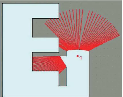
Gonz´alez-Banos and Latombe(2002) sample probabilistically the environment near the
2. STATE OF ART
the evaluation of a candidate position. This method is impractical in multi-robot because it requires sampling several positions to evaluate. This process is already time-consuming for one single robot, not to speak the complexity of the combinatorial analysis for the sampled positions. Furthermore,Holz et al.(2010) estimate that mono-robot this approach is less effective in exploration time than frontier-based approaches.
Figure 2.3: Evaluation of a candidate position as frontier of exploration target. The visible area outside the explored areas is evaluated by ray radiating from the candidate position (Gonz´alez-Banos and Latombe,2002)
2.4.3 Utility methods
The utility concept, originally proposed by Simmons et al. (2000), is defined as the difference or ratio between the cost and the gain of information associated with an ob-servation. It reduces for example the exploration of neighbor frontiers to those already assigned, as it only provides little information. Actually, a robot that observes a fron-tier also observe its neighborhood. Thus, the utility of a fronfron-tier exploration is inversely proportional to its distance from the assigned frontiers. The utility of the frontiers is reduced if they are visible (not separated by an obstacle and with a distance less than the perception radius) assigned from the border. If the frontiers are close enough, only
2.4 Assortment by identifying area to explore (target)
one robot can explore them in one single observation. The utility method provides a better distribution of robots in the environment than the frontier-based approaches with no grouping neighbor frontier cells.
2.4.4 Other approaches
Approaches ofWurm et al.(2008) andGossage et al.(2006) discretise the map partially constructed in Voronoi cells and assign the frontier cells to robots. Figure2.4illustrates the construction of topological graph based on Voronoi discretization. The nodes of the topological map are the nodes associated to the Voronoi cells. Robots are assigned to the unexplored cells. These methods are close to the methods using the utility and grouping frontier cells because they also avoid assigning multiple robots to the neighbor frontiers.
Figure 2.4: Graph based on the discretization of Voronoi (Gossage et al., 2006). The triangle represents the robot, the squares are the unexplored nodes and disks are explored nodes. The dotted lines show the perception of the robot.
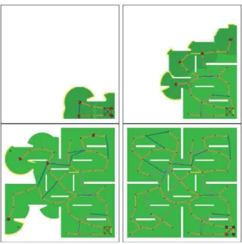
The approach of Puig et al. (2011) performs a segmentation of the environment with the K-means algorithm as many zones as robots. Therefore, one zone will be explored by one robot. Figure 2.5 shows the segmentation. This method distributes the robots in the environment for faster exploration. Its disadvantage is that it needs to know the size of the environment before exploration. It does not take the topology of the environment into account, which will pose a lot of problems if the environment is structured as one robot will eventually visit the zone assigned to another robot before being able to access the zone that has been assigned to itself.
2. STATE OF ART
Figure 2.5: Segmentation of the environment with K-means algorithm, with K equal to the number of the robots (Puig et al.,2011).
2.5
Assortment by assigning targets
The target can be assigned to the robots using different exploration methods, and we may summarise as below.
2.5.1 The nearest frontier
For one single robot, the method proposed by Yamauchi (1997), assigning the nearest frontier to the robot, is the most efficient method among the frontier-based method (see (Holz et al.,2010)).
Figure 2.6: Implicit coordination: three robots leave the explored corridor in the lower part of the figure, and separate in a balanced way before the crossing. The frontiers are in red, and the robot are in blue. Each robot goes to its nearest frontier.
2.5 Assortment by assigning targets
Yamauchi(1998) extends this method for the multi-robot case, and each robot goes
to its nearest frontier. In the process, if the partially constructed map is shared, the implicit cooperation will be carried out (see the figure 2.6). However, it is limited, because the robots may choose the same frontiers, with no advantage by their number.
2.5.2 Greedy algorithm
The Greedy algorithm tries to optimize the total cost of exploration by setting the pair robot-frontier with the minimum cost at each iteration. As iteration is performed on the robot, the equilibrium distribution of the robots on the frontiers is ensured. This algorithm is usually applied in a centralised manner. However, each robot, if it has the travel costs of all robots to each frontier, can run the algorithm until we obtain the distribution of the exploration. Figure2.7shows an allocation of the frontiers with greedy algorithm. Most frontier allocation approaches are based on this algorithm (Burgard et al.,2005), (Simmons et al.,2000) and (Zlot et al., 2002).
Figure 2.7: Illustration of the assignment of the frontiers with the greedy algorithm. The robot-frontier couple are assigned by the order of the cost from the lowest to the highest.
2.5.3 Greedy on the utility of frontiers
Burgard et al. (2005) use the greedy algorithm by adding a criterion of importance
at each frontier. Indeed, the algorithm is similar to greedy algorithm with updating the criterion after each assignment. The purpose of this approach is to minimize the exploration time by taking into account simultaneously the cost to reach the target and its ratio compared to the information gain (Burgard et al.,2002). The general principle of the algorithm is as follows:
2. STATE OF ART
1. initialise the utility of each frontier to 1;
2. find the robot-frontier couple having the maximum utility-cost difference and assign the robot to the corresponding frontier;
3. reduce the utility of all the frontiers in function of their distance to the previously assigned frontier (the nearer the robot is to the frontier, the smaller the utility will be);
4. go back to the second step if there is the robot without frontier.
This method gives better distribution of the robots, but may be difficult to decen-tralise, because the assignment of a robot will affect that of another. Moreover, the assignment of all the robots must be done simultaneously, which will pose a problem of synchronisation.
2.5.4 Hungarian method
The Hungarian method (Kuhn,1955) is an optimal algorithm for task assignment. It runs directly on a cost matrix. It finds optimally the minimisation of the sum of the exploration cost of each task. Its complexity is O(n3) where n is the maximum number
between the number of robots and the number of frontiers. It is suitable for assigning frontiers to the robots and has often been used for multi-robot exploration (Ko et al.,
2003; Wurm et al.,2008).
2.5.5 Optimal assignment
The minimisation of the sum of the cost by the greedy and Hungarian algorithm do not allow the optimal assignment of the robots on the frontiers (see Figure2.8). To obtain better results, it is necessary to list the solutions because it is always a competitive problem.
When the number of robots is small (less than ten), it is capable to generate all the possible combinations robot/frontier and determine which is optimal. When the number is more and more important, the utilisation of the second algorithm inBurgard
et al.(2005) is preferable, which consist of a random research combined to a local opti-misation method. However, the number of the robots must stay reasonable, depending on the calculation power of the central computer; according to the authors, this method
2.6 Assortment by communication mode
calculates the assignment of twenty robots in seconds and more than a minute for forty robots.
(a) Robot 1 tries to avoid robot 2 in the beginning, which takes longer time for robot 2 to finish the exploration task
(b) Robot 1 goes straight without con-touring the robot 2 at first place, which reduces the trajectory of robot 2
Figure 2.8: Comparison of two ways for robot 1 moving to point a and robot 2 to point b (Burgard et al.,2005)
Evidently, the implementation of these methods of target assignment can be carried out without communication between the robots. So the following section will describe the communication methods.
2.6
Assortment by communication mode
The first robots incapable to communicate their coordination between robots are dif-ficult to carry out a cooperative algorithm for exploration. The technological advance of the wireless communication allows developing better coordination strategies that we are going to study in this section.
2.6.1 Without communication
Communication is essential to ensure the completeness of coverage. Random explo-ration and wall following methods (see section 2.1) do not use communication but there is no cooperation between robots and they can not determine whether the explo-ration is completed. In practice, the method ofL´opez de M`antaras et al. (1997) uses a communication between robots which intersect to avoid losing data gathered by robots which do not return to the starting point. For the environment coverage,Howard et al. (2002) use a technique based on potential fields (Khatib,1986). These fields push the robots between each other and the obstacles. A motor schema (Arkin,1989) is used
2. STATE OF ART
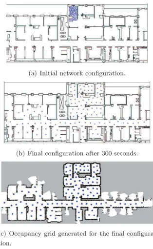
to generate an action in function of the potential fields in which the robot is placed. The only assumption of the approach is that robots can perceive the distance and the angle of obstacles and robots around by their sensors. Starting from the same zone, the robots are dispersed into the environment to maximize the coverage (see Figure 2.9). These methods do not build map simultaneously or construct map afterwards. They are not very effective for exploration, in fact, it is necessary to guide the robots to the unexplored zone. To do this in collaboration, the communication is essential. Robots that do not communicate have to explore the entire map respectively to determine if the exploration is completed.
(a) Initial network configuration.
(b) Final configuration after 300 seconds.
(c) Occupancy grid generated for the final configura-tion.
Figure 2.9: A proto-typical deployment experiment for a 100-node network (Howard
2.6 Assortment by communication mode
2.6.2 Indirect communication
Approaches with no direct communication between robots are based on the markers of the environment, for example, with digital pheromone (Glad et al., 2009) by using markers and tags. The environment which is often a graph in the form of a cell grid, robots leave marks containing a value in visited cells. The exploration is done with ant agents (very simple agents with very limited perception). For example, LRTA* methods (Learning Real-Time A*) (Korf, 1990) and Node counting (Wagner et al., 1999) use the same strategy: agents head to the neighbor cell with the lowest value. These algorithms differ on how to update the values of the markers. LRTA* guide the robots to the nearest unexplored cells in a similar manner (Yamauchi, 1998). With the Node counting algorithm, each cell of the environment maintains the number of times the cell has been visited by a robot, robots thus head to the nearest cell the most previously visited. Koenig et al. (2001) prove that LRTA* guarantees the exploration of the environment in polynomial time while Node counting method has a complexity in exponential time. These approaches are easy to simulate but difficult to implement in robots. Furthermore, the agents do not build maps but fill a grid; they can not check if exploration is completed (limited perception and no memory).
2.6.3 Explicit communication
The explicit communication of information and of data between the robots can use different forms. In fact, the robots can explicitly exchange information on the environ-ment, which allows them to coordinate implicitly. And they can directly exchange the coordination information:
Share the map/Implicite cooperation In (Yamauchi, 1998), the coordination is implicit, because it does not use the exchange of the message for coordination between the robots, which leads to the construction of the global map. The robots share the collected local information in order that each of them produces a similar map, providing a list of similar frontiers. Each time one robot carries out an observation, it broadcasts the result to the entire fleet. There is no communication for the explicit coordination of the robots. It is a distributed system, where each robot decides its going direction autonomously.
2. STATE OF ART
Explicit communication for the coordination An explicit communication between several robot leads to the development of a number of methods, the principles of which are explained as below.
Auction system The auction systems operate in two stages: first an auction phase based on communication either between robots or with a central server will be carried out, followed by a phase of assignment. Assignment of fron-tiers generally uses the same principle as Greedy algorithm. In practice, each robot emits a auction on each frontier, and it wins a frontier for which it has the best auction. Zlot et al.(2002) and Chaimowicz et al.(2002) developed a distributed method where robots who discover a frontier are auctioneers for it, other robots bidders.
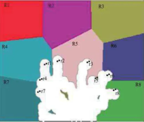
Strategy by groups of robots In the approach of Franchi et al. (2009), co-operation is carried out by sharing a topological map of the environment. The robots autonomously choose their target but coordinate when targets or paths are in conflict. The coordination between robots is obliged when the inter-distance between their target is less than two times the radius of perception. Coordination is then made from the chain of robots satisfying the criterion of inter-distance as follows: during the coordination phase, the robots stop their movement, synchronise and decide in this subgroup of coor-dination strategy. If the paths to the target are in conflict, a group leader is elected and resolves the conflict by assigning targets or leaving some robots stopped. Figure2.10 shows a group of robots coordinating.
2.6.4 Centralised approaches
Many approaches use a central unit to collect information from each robot, build the partial map, calculate the cost for each robot and finally distribute tasks to each robot
(Wurm et al.,2008). Thus, communication is centralised to the single and unique leader
robot. During exploration, leadership can be attributed to different robots.
Other approaches distribute a part of the calculation. Thus,Simmons et al.(2000) propose an approach based on frontier exploration and a simple auction system. Each robot evaluates the benefit of exploring each frontier by determining the travel cost and
2.7 Conclusion on the state of art
Figure 2.10: Example of GPA/GEA construction. Top: The GPA of robot 4 consists of robots 1, 3, 4, and 7: robot 1 is still moving toward its target point,while robots 3, 4, and 7 are stationary. The perception areas of the robots (prospective in the case of robot 1) overlap in pairs. Bottom: Once the LSR have been computed, only robots 3, 4, and 7 belong to the GEA of robot 4 since their LSRs overlap in pairs (Franchi et al.,2009).
the estimation of the next ratio compared to the information gain. It sends then an auction on the frontiers, evaluated at a central agent who, once bids of all robots receive, assigns the frontiers to robots in a greedy manner, avoiding the overlapping of coverage of each robot. Stachniss et al. (2008) use the same kind of approach but provide a priori information on the topology of the environment which allows to take the type of area to explore (corridor, room, etc) into account. Note that these approaches are partially centralized but they have the same fault with a centralized approach because they contain a centralisation point which can be a source of system failure.
2.7
Conclusion on the state of art
The multi-robot exploration was discussed with different objectives: accuracy of the constructed map, maximum coverage and complete exploration in a minimum time.
2. STATE OF ART
Whatever the objective we are looking for, we have seen that to develop an effective exploration strategy, we have to consider the sensor range and communication range between robots. Centralized strategies enable efficient exploration through efficient co-operation, but they are difficult to apply with a large number of robots. The approaches with no communication or indirect communication allow the cooperation but can not build map, and can not guarantee the completeness of exploration. Strategies based on explicit coordination induce a communication cost which does not allow to apply with a large number of robots. The implicit coordination proposed byYamauchi (1998) is a good compromise between communication and cooperation, but its performance is far below the approaches using explicit coordination. In this thesis, we are interested to complete exploration of environments in a minimum time and we propose a strategy based on implicit coordination, with a performance similar to the approaches of explicit coordination.
The above problem is very rich in variants and constraints. In the next section we specify the problem statement and its variants.
3
Robot exploration
Contents
3.1 Single robot method . . . 32
3.1.1 Frontier-based exploration . . . 32
3.1.2 Frontier detection . . . 33
3.1.3 Navigation to frontiers . . . 34
3.1.4 Recording the explored area . . . 34
3.1.5 Proposed exploration algorithm . . . 35
3.2 Multi-agent approach . . . 36
3.2.1 Problem setting . . . 39
3.2.2 Cost function . . . 41
3.2.3 Computing utilities of frontier cells . . . 43
3.2.4 Target point selection . . . 44
3.2.5 Coordination with limited communication range . . . 45
3.3 Conclusion of robots exploration . . . 46
The Exploration problem can be modeled as the travelling salesman problem (TSP) or the shortest watchmen route problems. Since the original art gallery problem is non-deterministic polynomial completeAggarwal (1984) and always requires complete knowledge about the environment. As a matter of fact, mapping is an incremental pro-cess. Since the ranges of the sensors (ex. sonar or laser) are limited, measurements are inaccurate, and errors may occur along the process, that is why map building is usually performed by taking several measurements of environments at different positions and