Architecture as a Stage for Play and Self Expression: An Intervention of Public Open Space in Istanbul, Turkey
Rukiye Devres
Bachelor of Science in Art and Design, Massachusetts Institute of Technology
Cambridge, MA May 1993
SUBMITTED TO THE DEPARTMENT OF ARCHITECTURE
IN PARTIAL FULFILLMENT OF THE REQUIREMENTS FOR THE DEGREE
MASTER OF ARCHITECTURE
AT THE
MASSACHUSETTS INSTITUTE OF TECHNOLOGY
FEBRUARY 1996
@ Rukiye Devres 1996. All rights reserved.
The author hereby grants to M.I.T permission to reproduce and to distribute publicly paper and electronic copies of
:us rTS IN- ''U TZ
OF TECHNOLOGY
MAR 2
0
1996
LIBRARIES
this thesis document in whole or in part.
Signature of the Author ,
Rukiye D vres, Department of Architecture January 12, 1996
Certified by
Jan Wampler, Professor of Architecture Thesis Supervisor
Accepted by
Ann Pendleton-Jullian, Assistan rofessor of Architecture Chairman, Departmental Comittee on Graduate Students
Figure 1. my Parents
To my Parents, my Brother, Mlle Marie Therese Dubuis, Aunt Necmiye Sagan, and my Teachers.
Architecture as a Stage for Play and Self Expression:
An Intervention on Public Open Space in Istanbul, Turkey
by Rukiye Devres
Submitted to the Department of Architecture on January 12, 1996 in partial fulfillment of the requirements for the degree of master of Architecture.
ABSTRACT
People of all races, cultures and religious backgrounds share the need for public places which allow for human interaction and self expression. Unfortunately, in Istanbul, a city of twelve million people where public space has historically been associated with the mosque, historical precedents for secular public places such as this do not exist. Since the decline of the role of religion in social and governmental settings, the mosque courtyard has become primarily a place for ablution, and has lost its quality for gatherings. Yet, today, the city fabric has not changed to accommodate for the space which the mosques provided long ago. As a result, there is a great need for the improvement of public space, and for the making of new public gathering places in Istanbul.
This thesis explores the introduction of a public open space into one of the unused sections of the waterfront in Istanbul, and the site for this project is that of the old loading docks and warehouses located across from the Tophane Museum--the historic Ottoman Artillery.
The proposed plaza is located at a crossing of many transportational and recreational paths accentuated by the design. As a result the place becomes a nodal point. Self expression and play are the guiding forces behind the program which revolves around a big pool, full of activities, which recognizes water as the life giver to the city of Istanbul.
Thesis Supervisor: Jan Wampler
Acknowledgments
Jan Wampler. Your kind understanding of people's problems in today's world, and your
support for them in your architecture and your teachings is what has inspired me and has made you who will always have my highest respect. Thank you for helping me see a bit more clearly, and for helping me grow stronger and more patient.
John Myer. I am most thankful for the sincere patience and clear guidance you have
shown to me not only this term but in all the projects I have entertained in your company.
Nasser Rabbat. Even at short notice, thank you for always giving me your undivided attention when I needed it most.
Krzysztof Wodiczko. Thank you for your support, enthusiasm and guidance. Hasan-Uddin Khan and Jaehoon Lee. It would not have been the same without
your support and helpful understanding.
Charlotte Williams, I could not have done it without you!
Barbara Brady, your support and help with all aspects of this project meant a lot to me.
my fellow friends on the third floor, Bundit, Melanie, Nina, Scott, Soo, can you imagine my model without the existing buildings, and your hard crits? Neither can I!
my studio friends who kept me from going insane on my project--not theirs! my thesis mates, we made it, congrats....
and Cem who took care of me and fed me when I was sick and desperate about how to finish this thesis on time.
Thank you Rukiye 4
TABLE OF CONTENTS
A b stract...3
Introduction...7
Background on Plazas...11
Piazza San Marco...12
Piazza Navona...14 Ortakoy ... 15 Beyazit ... 18 Background...21 S ite ... . .. 27 Site Intervention...37 The Concepts... 40
The Plaza Proposal...53
The Mde ...Mo e...65
Conclusion...77
Illustrations...81
Bibliography ... 87
INTRODUCTION
do d d 44 4# 4 ma I d 4 10 4 4 4 4 4 4 mumman 4 4 4 d d 4 d dd go A 4~ 4a 4 41 ISTANBUL CITY PLANFigure 2. Istanbul City Plan IsoooOmeuc
4 a
This thesis supports the idea that all people, everywhere need public open space. Such places can be used for different purposes, but this project explores an urban plaza as a place for play, self exploration and
expression--as these are basic human needs. For this investigation, I picked a city and an area which is in great need public spaces.
Istanbul is a city where public open spaces have historically been characterized by the mosque courtyard and garden. The map in figure 2 shows the number of old mosques in the area of the Golden Horn and in the rest of the city. Their multitude reflects the density of public space that was available to the residents of the Ottoman city through the role of the mosque and religion. But, since 1923, when the Turkish Republic was founded by Ataturk, the role of religion changed and these mosque courtyards lost their importance. Most mosque courtyards are no longer considered by the men of the community as places for gathering and discussing of political and social events. In Turkey, such matters have been completely separated from religion, and with the new Republic, women and men have equal rights. Yet, new public spaces replacing the role of the mosque courtyard have not been introduced into the urban fabric of the modern city. Public
intersections and squares which were present before, have now become parking lots and are congested with car traffic. Fortunately, in the last
Figure 3. The New Gardens on the banks of The Golden Horn
photo from Les Treso d['Istanbual by Aksit
decade, out of need for public space, people have transformed some ferryboat landings into tiny plazas in order to accommodate cafes for the flow of people who inhabit the waterfront everyday. Also, in the 80s, Mayor Dalan built a system of small linear parks along the waterfront of the Golden Horn and the Bosphorus. These parks, illustrated on figure 3, are more like a series of small gardens and have tried to alleviate the need for public open spaces in the city. Yet, they lack a great deal of definition, and
they do not suffice; they certainly do not work like urban plazas. In spite of the Mayor's efforts to bring life back to the dilapidated sections of the waterfront, public open space is lacking in the city of Istanbul, and this is due to the fact an alternative to the space which was provided by the mosque courtyard and gardens has not been woven into today's urban fabric.
The investigation for this thesis started by questioning the problem of this grand city and looking at the possibilities for introducing a
vocabulary of new urban plazas into a city with no precedents for secular public open places. The challenge is defining the physical quality of one
BACKGROUND ON PLAZAS
To provide background on the quality, form, size and use of public places, two Italian plazas and two successful public spaces in Istanbul were studied. What differentiates these plazas from this project is the intervention of the new plaza into an old setting. Showing the success of public spaces
and the need for them justifies a modem interpretation of the plaza and its insertion into modem cities.
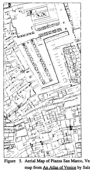
Piazza San Marco
The idea of this project was inspired by this famous plaza. The magnitude of the space and the stage-like feeling it evokes for the inhabitants
of the plaza is important to the quality of space explored in this thesis. The theater-like setting and the generosity of contained space is so successfully crafted here, that it is crucial to understand the simplicity of the space and the physical freedom it provides to its "inhabitants" in terms of the activities which occur in it. Thin long buildings surround the plaza on three sides, and the San Marco Church provides a large stage setting on the northeast side. There are small cafes and shops on the ground floor of the buildings, but the use of the buildings does not carry the significance which the plaza carries. Concerts, performances, displays, casual strolls and
Figure 5. Aerial Map of Piazza San Marco, Venice
many other activities fill the plaza and the architecture around is just the faithful keeper and the "scene."
A most important reference for this investigation, Piazza San Marco is situated on a large site, by the water. In many ways, its location and size evoke much of the same feeling as the site chosen in Istanbul; therefore, the specific size, form, and activities of this plaza are particularly relevant to this thesis.
The plaza measures approximately ninety meters by forty meters in the widest area and is paved completely. When the waters of Venice rise, water seeps up through the pavements on the plaza, turning it into a kind of ''water plaza."
The vertical landmark of this area, much like the minaret of the mosques and the clock tower situated on the site of this thesis project, the campanile is the marker of this place for people approaching from sea or land. Its imposing vertical presence couples with the steeples and the cupolas of the little towers and the Church to act as the guardians of the plaza. In addition, the Palace of the Dodges and the waterfront are part of the backdrop to this beautifully conceived space through which many people
pass everyday. Figures 5 and 6 show the plan and aerial view of Piazza
San Marco, respectively.
Figure 6. Aerial-hoto of Piazza San Marco, Venice,
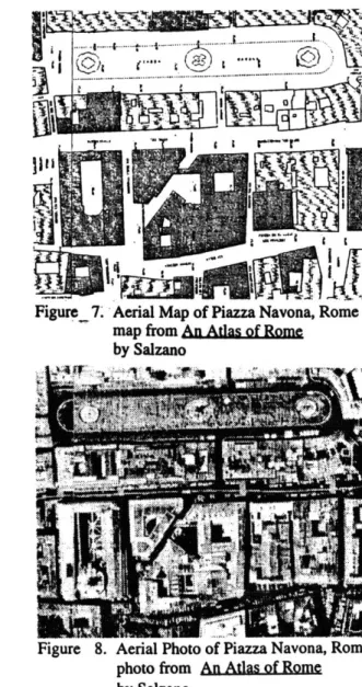
Piazza Navona
The old civic and commercial nature of this plaza and its current use for recreation, exhibition and performances is relevant to this thesis. The fountains' dominant presence enhance the beauty and the public recreational aspects of this plaza, while making a reference to the past when men, women and children mingled around the fountains and the market which took place next to them.
Again, the size and use of this piazza also provides a good
reference. The piazza measures one hundred and thirty meters by twenty six meters; but, unfortunately, car traffic uses part of this space on the periphery. Surrounding the plaza, there are cafes and shops all around, and
though the beautiful buildings house a mixture of government offices, consulates and residences, their use is not so important to the plaza. The
plaza is important because of the activities and the people it welcomes, and the architecture is important because it contains the space and celebrates it. Figures 7 and 8 show the plan and the aerial view of the plaza as it stands today.
Figure,7. Aerial Map of Piazza Navona, Rome map from An Atlas of Rome
by Salzano
Figure 8. Aerial Photo of Piazza Navona, Rome photo from An Atlas of Rome
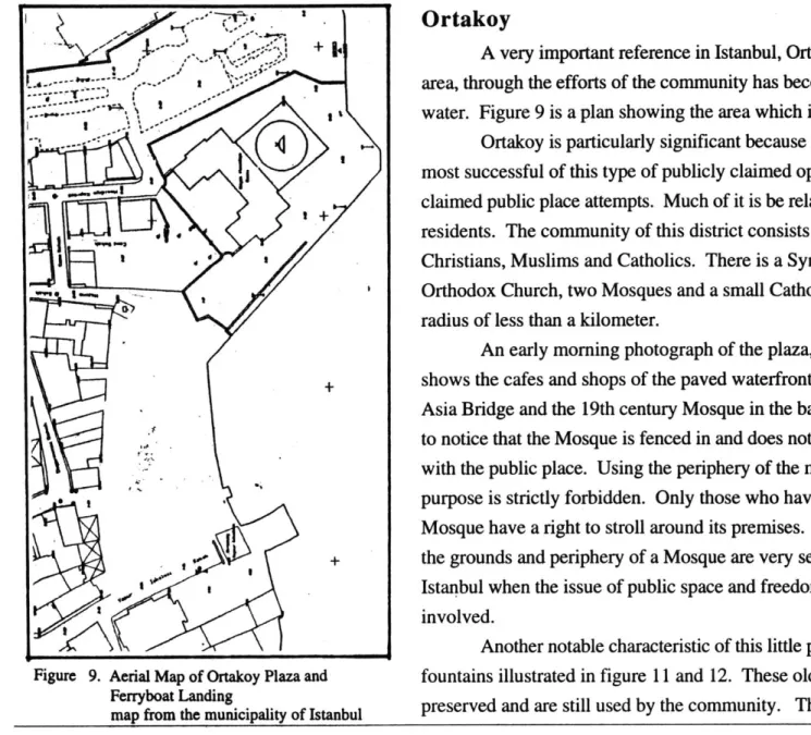
Ortakoy
A very important reference in Istanbul, Ortakoy's ferryboat landing
-. , area, through the efforts of the community has become a small piazza on the
O
~water. Figure 9 is a plan showing the area which is an active place today.
Ortakoy is particularly significant because it is the first, largest and most successful of this type of publicly claimed open spaces in Istanbul. claimed public place attempts. Much of it is be related to the variety of the residents. The community of this district consists of Jews, Orthodox Christians, Muslims and Catholics. There is a Synagogue, a Greek Orthodox Church, two Mosques and a small Catholic Church within a radius of less than a kilometer.
An early morning photograph of the plaza, shown on figure 10, shows the cafes and shops of the paved waterfront with the first Europe-Asia Bridge and the 19th century Mosque in the background. It is important to notice that the Mosque is fenced in and does not share its waterfront area
with the public place. Using the periphery of the mosque for recreational
purpose is strictly forbidden. Only those who have "business" in the Mosque have a right to stroll around its premises. This clearly shows that the grounds and periphery of a Mosque are very sensitive subjects in Istanbul when the issue of public space and freedom of activity are involved.
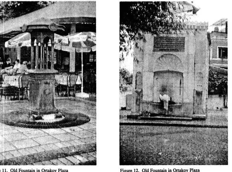
Another notable characteristic of this little plaza is that of the two
Figure 9. Aerial Map of Ortakoy Plaza and fountains illustrated in figure 11 and 12. These old fountains have been
Ferryboat Landing peevdadaesilue ytecmuiy hi rsnemr h
public space as an old square and an intersection of paths, because that is where fountains were situated in old days. This gives the plaza a sense of memory and tradition relative to the fountain, and to the past uses of this space which related to the public.
Beyazit
Figure 13. Aerial Map of Beyazit Meydani map from the municipality of Istanbul
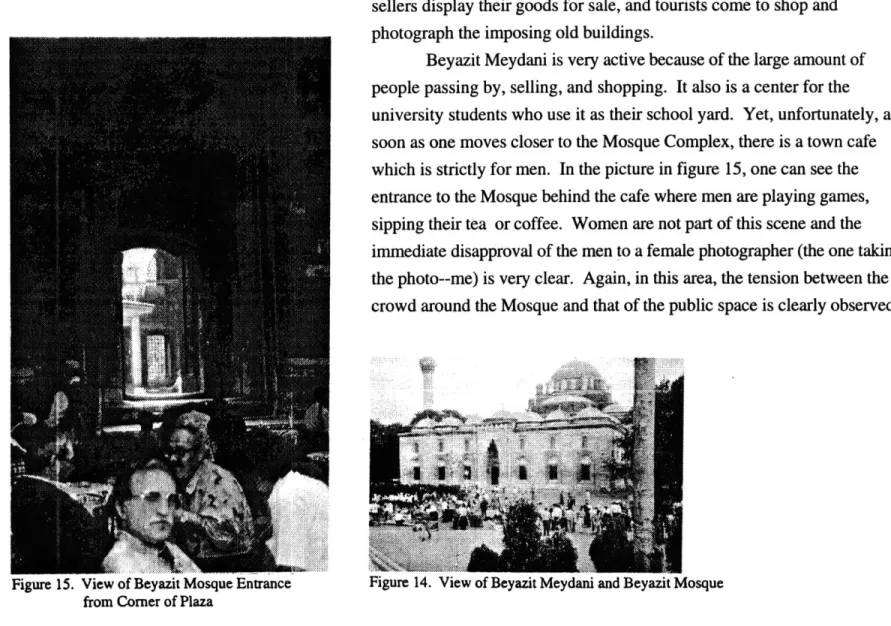
Another widely used public space in Istanbul is the Beyazit Meydani. The map on figure 13 shows the general area and figure 14 shows a portion of the square with the old Beyazit Mosque in the
background. This space is surrounded by the buildings of the University of Istanbul and the Beyazit Mosque Complex. In old days, this space served
the Mosque, but today it is a large, paved, "in between" space where street sellers display their goods for sale, and tourists come to shop and
photograph the imposing old buildings.
Beyazit Meydani is very active because of the large amount of people passing by, selling, and shopping. It also is a center for the university students who use it as their school yard. Yet, unfortunately, as soon as one moves closer to the Mosque Complex, there is a town cafe which is strictly for men. In the picture in figure 15, one can see the entrance to the Mosque behind the cafe where men are playing games, sipping their tea or coffee. Women are not part of this scene and the immediate disapproval of the men to a female photographer (the one taking the photo--me) is very clear. Again, in this area, the tension between the crowd around the Mosque and that of the public space is clearly observed.
Figure 15. View of Beyazit Mosque Entrance from Corner of Plaza
BACKGROUND
'Ye~Ah~
- a4
Figure 16. Map of Istanbul the 1950s
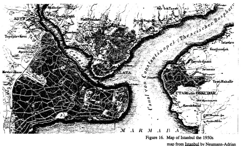
Istanbul was the capital city of two empires: Byzantine and Ottoman. Geographically, the modern city sits on the banks of the Bosphorus, which is the straight dividing Europe and Asia. On the European side, the land is again divided in two by a narrow inlet which forms the historic peninsula of the Seraglio Point and the Galata district across from it (see figure 16). For one entering the city by water, the Golden Horn physically, visually, and historically marks a very impressive gateway.
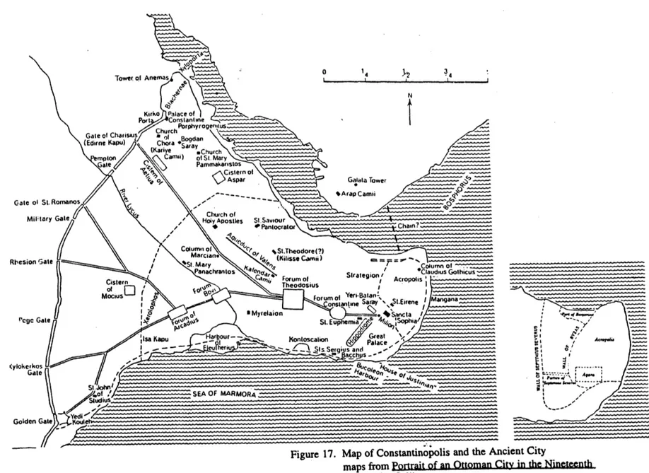
Unfortunately, little evidence remains of the first settlements, but, early colonists seem to have been fishermen and tradesmen who settled in the Galata area. They had a harbor along the Golden Horn with two adjoining open spaces. Later, as shown on figure 17, the center for the Acropolis, temples, theaters, and other structures were built on the present site of the Topkapi Palace.
In 330 A.D., Constantine brought the capital of the Roman Empire to Byzantium, and the city became known as Constantinople--Constantine's city. He, in turn made a master plan for the city, and reinforced its walls . Again the inlet of the Golden Horn was the harbor, and the main entrance to the City. During the reign of the Ottoman empire, the place of the harbor
Gate ol St.F
Miltary
Rt'esion GateSt. Mary >,lnmsse L~amn _=___=__-_umn of_
Panachraos nClaudius Gothicus
Cistern '"/Forum of Acropolis
Of Theodosius
Mocus Forum of Yeri-Batan Mangana
onstantne Saray St.Eirene I angana
k \II o Myrelaion -... Sanca
rg e St. Eup ma Sophia/ Harour s --p rat- p as (y____oke___ a -- a Aae . o,)SEA OF MARMORA - ____ Studiusgusan Yed -- --- -Golden Gate ._
Figure 17. Map of Constantinopolis and the Ancient City
maps from Portrait of an Ottoman City in the Nineteenth Cenury by Celik
never changed. Galata was rented to the Genovese and the Venitians as a trading post, and the inner part of the Horn housed the Sultan's navy (Summer-Boyd and Freely, 1983, p. 45).
Trading made the Galata Quarter wealthy and the area grew into a large and diverse neighborhood which survived many fires. However, a series of large fires during the mid 1800s destroyed much of the urban fabric, and the area of Pera and Galata were rebuilt in a regularized,
rectangular pattern which can still be observed today in the preserved parts of the district. In 1850, the first bridge which linked Galata to the Eminonu on Seraglio Point was built. As a result of this physical connection,
communication improved, both sides of the bridge prospered, and the city started to grow towards the North, along the banks of the Bosphorus. Naturally, Galata became ever more central (Summer-Boyd and Freely,
1983, p. 56).
Unfortunately, in the beginning of the 20th Century, the Golden Horn started accommodating the growing need for industrial land around the city. As a result, this area which is the center, the heart, of the city became an industrial zone, and soon after, the waters of the Horn turned
into a toxic cesspool. Galata and beyond fell from grace.
In the early 1980s a visionary mayor moved all of the industries to the outskirts of Istanbul, and transformed certain areas of the waterfront into small parks for recreational activities. But, his proposal did not reach as far as Galata, which had become the main commercial port for Istanbul, and the waterfront was invaded by warehouses, customs, and government
buildings which stood like a wall between the people and the water. This barrier destroyed public activity around the fountains and mosques, and the
neighborhood was lost to increasing decadence. Today, Galata is a "mini port," and in spite of the main commercial port being moved to the Asian side, warehouses and useless buildings still block the waterfront of the old district. The historic fagade of Galata is no more.
Galata has an incredible view of the old city, the new city, Asia, Europe, the cross-continent bridges, the Bosphorus, the Marmara and the Golden Horn. It houses beautiful historic buildings, is very central, and is a major water stop for domestic ferrys. Commuters and residents
continuously travel the streets and the limited open areas of the waterfront. Yet, it has become a run down, old place which yearns for a better life.
THE SITE
Figure 19. Photograph of Fishermen by the Galata Quay Figure 18. View of Galata from Beyazit
The specific area chosen for the project used to house the custom warehouses for the city's old port. These are currently being moved to the vicinity of the new Port, and it is not certain if the municipality will declare this portion of land zoned for tourism; but, for now, this long strip of waterfront is left functionless and undefined. Figure 21 shows the back and figure 22 shows the front of a warehouse on the site.
The Galata quarter is historically very rich and quite beautiful. Its views and access to the Bosphorus, the Golden Horn, and old Istanbul are unique. Figure 22 and 23 show the heights of the old quarter with its ancient observatory, the famous Tower of Galata, in the background. Unfortunately, the buildings are now dilapidated, and the industrial and commercial business related to the old port has kept public interest away. Although the area is a major landing spot for domestic maritime lines and city ferryboats, the neighborhood has not been appropriate for general public interaction. Figure 24 shows the quay in the fifties, and figure 25
illustrates it as it is today. From the photos, one can clearly observe the flux ..
of people that go through this area everyday. Aside from the action provided by the ferry dock, there are a variety of other activities such as
sailing, touring and fishing. Figure 20. Photograph of Back of Warehouse on
Figure 21. Photograph of Front of Warehouse
on the Site
Recently, in an effort to embellish the area, small public gathering areas, cafes, and restaurants have sprung up. People living in the area have pushed for the relocation of the industry and some of its related businesses. Yet the quarter is still a misfit in the waterfront fabric and needs to regain an identity.
Right now, Galata is completely isolated from the rest of the coast along the Bosphorus leading up to the black sea. A big part of the problem is the long stretch of land where the warehouses sit parallel to the water. They are closed to public access and create a wall between the district
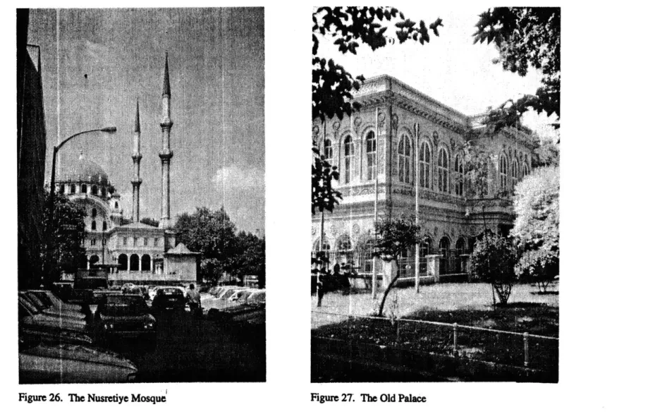
activities and the water. They also disconnect the old Ottoman Artillery, the beautiful mosques, and the small buildings from the sea and the district. This is unfortunate, because the Artillery Museum and the old fountain just float in an area of the site with no specific purpose or use to the community. The Nusretiye Mosque complex shown on figure 26, and the small Palace
shown on figure 27 suffer from the same problem.
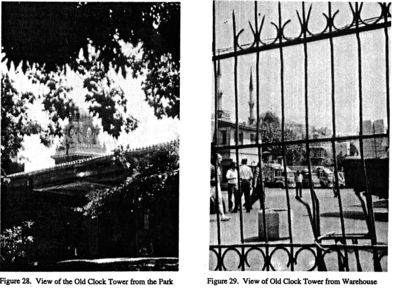
In addition, as seen on figure 28 and 29, there is an 19th century Clock Tower trapped between the warehouses on the site. It is inaccessible and can only be seen from a few rather awkward locations. In the early
1900s, the sea used to come to the front of the Clock Tower and also the fronts of the Nusretiye Mosque and the Kilic Ali Pasa Mosque and Complex as illustrated on figure 30. One can also see the Artillery to the right of the Mosque. Today, there is still a green space behind the warehouses where the Mosque, Palace and Artillery stand. Figure 31 is a view of the area taken from the Galata Tower showing the old buildings, the green space and
Ebb4I
Figure 22. View of Galata Tower from the Neighborhood Figure 23. Watercolor View of Galata Tower from Stairs image from Les Tresors d'Istanbul by Aksit
Figure 24. Watercolor View of Galata Quay.
image from Las Tresors d'Istanbul by Aksit
Figure 25. The Quay of Galata
Figure 30. Illustration of Kilic Ali Pasa Mosque in 1580
illustration from Istanbul by
Neumann-Adrian
Figure 32. View of Street Adjacent to Site
Figure 31. View of Site from Galata Tower
the warehouses. In figure 32 one can see the major road which cuts through the green strip, separating the artillery from the site. Figure 33 documents the undefined green space immediately behind the warehouses.
THE SITE INTERVENTION
AND PROPOSED w OVERLAYED
Figure 35. Conceptual Sketch,
The intervention proposed in this thesis is the introduction of a public plaza into the area of the old Navy warehouses. This plaza serves the function of providing a public space, while also bringing water into the site and making connections between land and water, and people and water activities. The master plan at the city scale requires the rediging of most of the infilled area from the back of the Nusretiye Mosque to the waterfront, and the making of a canal from the front of the Mosque all the way down,
behind the warehouses to the little cove next to the Mimar Sinan University. Figure 34 shows the relationship of the existing condition to the proposal.
The plaza gives definition to the site and funnels natural public energy into the area and into a powerful urban space. Articulating the site as such provides links between large landmarks upstream and downstream which have been long disconnected from the Galata Quarter at the city scale.
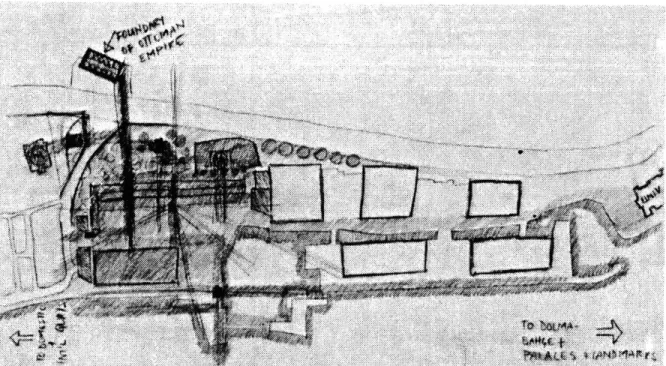
Connections at the district scale are even more important and figure 35 is an
early sketch attempting to establish a relationship between the nearby historic buildings and the plaza. As a result of such an intervention, the urban fabric on both sides of the site would fine-tune and integrate itself into the neighborhood.
The reintroduction of water into the site, and the introduction of a long pedestrian dock for ferryboat access brings people physically closer to the water and the activities it offers. Also, a marking tower at the end of the
dock starts to create a dialogue with the old Kiz Kulesi--the ancient lighthouse--situated across the Bosphorus. Coupled with the Kiz Kulesi and the Sarayburnu--Seraiglio Point--Tower, the dock tower defines an area of entrance and exit to the Golden Horn and the Bosphorus straight. It adds to the landmarks that define the waterways. As a result, the plaza becomes the missing landmark connecting the Golden Horn to the rest of the
European coast of the Istanbul. The city plan on page 7 shows the site as the series of landmarks as they appear today in the fabric of Istanbul.
Concepts
Much of the preliminary work involved making a decision about the future of the whole area occupied by the warehouses and where the plaza would be situated in relationship to it. Figure 36 shows an early study model of the whole area. The plan involves digging up much land in front of the mosque and the Clock Tower to help bring water back into the site as it used to be in the 1900s--see figure 35a. In the process, one warehouse and a few other small buildings have to be taken down. Exposing the mosque and the tower to the seafarers has two advantages. The site is broken down into discernible pieces. First of all, this allows the plaza and the important buildings to stand out . And second, the relationship of water to land becomes much more intimate and efficient.
Creating a small channel between the cove by the university and the larger cove in front of the Mosque allows the other two warehouses to be separated on an islet until they are designated for new and more appropriate uses for the area. In addition, a small water route accessing the whole area is established from one end of the site all the way to the other end.
Separating that piece opens exciting possibilities for future development of the site, and allows an easier staging for the masterplan. Again, figure 34 on page 37 shows existing situation in comparison to the proposal.
A close up look of the model in figure 37 illustrates the effort to preserve the existing buildings and conceptually lay out the ideas for this
celebration of the old tower and of a new fountain, and the formal effects of the boats and sailboats are all compacted into this early model.
The next model, in figure 38, still attempts to preserve the existing buildings as much as possible but brings the water further into the site to completely expose the mosque. Now, the mosque is used as a backdrop and is visually completely accessible to the plaza while it is not physically in it. This relationship is very important based on the studies of the effects the mosques have in public circles of Istanbul. In the close up of the same model, figure 39, there is a pool in front of the fountain and the columns around are part of a special progression involved with this mass of still water. The idea is that light sail and wave like forms would provide temporary cover over the columns when necessary.
Figure 40 is a later sketch marking a turning point in the
investigation. Because they obstruct the direct connection of the site to the water, the existing buildings are being replaced by a first attempt to create a new and exciting plaza.
Water became increasingly more important in the scheme as a tool to explore play and self exploration on the plaza. Conceptual models defining the plaza were very important. They conveyed the exciting qualities an interactive pool with a series of fountains, walls, and paths can have on a public space. Other preliminary conceptual work studying the site and the pool are documented in figures 41 and 42.
In the next stage of the process, displayed in figure 43, a diagram for the layout of the plaza slowly emerged. The pool has now become the
00 U 40 00
0.
to
Figure 41. Conceptual Model
*
.C A C2
00
Figure 44. Diagrammatic Sketelf
heart of the plaza and is part of the path as well as the place. It has different levels and is backed by a platform looking onto the pool, the sea, and the long dock. Finally, the plaza is diagramatically outlined. The next step is to try and enclose the plaza so that the space does not leak out to the sea. As a result, the blackened areas in figure 44 gain importance and become focal points.
Slowly the placement of the program becomes apparent. In figure
45, the screen and stage are placed behind the pivoting corner of the pool, and the rest of the plaza and the levels in the pool act as informal stages. In an effort to provide continuity and visual connections to the water, the pool extends out towards the street creating a "Z" like form diagrammed in figure 46. The model documented in figure 47 shows the study of the different levels and the pool's relationship to the landscape of the plaza. Much work followed these preliminary steps which led to the proposal of the new plaza.
Figure 46. Diagram of Proposal.
a I
-THE PLAZA PROPOSAL
Figure 48. Overall Photograph of Proposal Model Figure 49. Overall Photograph of Proposal Model Figure 49. Overall Photograph of Proposal Model Figure 48. Overall Photograph of Proposal Model
The proposal is to build a public plaza in the Galata Quay area. The plaza is located across from the old Ottoman Artillery which is a museum today, and between the Kilic Ali Pasa and the Nusretiye Mosques, in the place of the old, dilapidated warehouses. The proposed plan is shown on
figure 50 and the district plan illustrates these changes on figure 34, on
page 37.
The plaza would be framed by an auditorium, exhibition space, and a commercial building which would provide cafes and shops along with the outdoor activities. Underneath the long commercial building and the
auditorium, there is a large parking lot which would help support the
increasing need for parking in the area. The set of use diagrams in figure 51 show the existing and proposed conditions. The impact of taking away the industrial port section and reconfiguring the site by inserting the plaza is very clear; the effort is to create connections. First, between the ferryboat landing on the waterfront of the plaza and the bus stops by the street, next to the park. And second, between the Artillery museum, the university and the rest of the city. Figure 52 shows set of transportation diagrams linking the water traffic to the streets via the bus stops on the proposal. Additionally, this plaza would be a great connector of paths between the Fine Arts
FERY
GROUND FLOOR PLAN Figure 50. Site Plan
University, Mimar Sinan, and the living quarters of the Galata area, as well as between the Museum and the old Mosques, the old Fountain and the old Palace.
The presence of the plaza opens up this section of the waterfront for people's use. The plaza becomes a center with the auditorium which services the institutions in the area and the exhibit space which puts the old buildings by the site on a permanent display along with new work which would be installed there at different times. That provides the endangered, little, existing park in which all these pieces already sit, a strong use and
definition in the urban context. Figure 53 shows the set of open space
diagrams reflecting the changes in the amount of connected public space in the area as result of this proposal.
The plaza itself contains a large pool with platforms at different
levels , and little niches and corners to be used for different purposes such
as reading, meeting a friend, gathering in groups, playing with water, and washing hands among other activities. The pool acts as a reference to the old custom of having fountains at intersections of paths, and in public areas
such as small gardens and the courtyards of the Mosques. It brings a new use and definition to an old prop.
Combined with the pool and plaza there is a formal stage which breaks down into informal stages. The stage is accompanied with a large, double sided screen which can be watched from the plaza as well as from
KEY fV COMMERCIAL Ei RESIDENTIAL 0 INSTITUTIONAL N HISTORIC D OPEN SPACE Bl PARKING a industrial
KEX 12 PRIMARY ROAD 9 SECONDARY ROAJD * TERTIARY ROAD 0 PEDESTRIAM ROAD 9 FERRYBOAD WATERWAY
li
\
Figure 52. Transportation Diagram PROPOSED
Figure 53. Open Space Diagram 59
the sea. This screen would be used for community events, lectures, movies, performances, advertising, and other activities associated with the plaza.
Another important aspect of this plaza is the shape of the roofs of the
proposed buildings. Looking at the roof plan illustrated in figure 54, one
can observe two types of roofs. One is the flat roof with the service shaft protruding at the top. This gives the buildings a boat like silhouette which
blends in with of the ferryboats. Sections C and D shown in figures 57 and
58 illustrate this relationship. A good example for this kind of water
architecture is also seen in Genoa, Italy. The second roof type is a wavelike form which floats over the buildings and can be experienced by the people
in the plaza. Sections A and B shown in figures 55 and 56 illustrate this
relationship. This type of form also works quite well with the domed architecture of the surrounding historical buildings and dialogue with them. Also, the curved shape of the roofs distinguish the plaza from the rest of the surrounding fabric and mark the site from a distance as a landmark along the water.
ROOFPLAN
us ETame
Figure 54.. Roof Plan
1"- 6 SECTION A
Figure 55. Section A
I"= 16 SECTION B
-16 SECTION C
Figure 57. Section C
r. W SECTION D
The Model
Figure 50, on page 55, shows a detailed plan of the proposal at
ground level. There are four points of entry from land and then, access from the sea to the plaza. Two entries are on the ground; one coming along the waterfront, from the quays of Galata, and the second form the park area by the street--where the Nusretiye Mosque and the old palace are located. The other two entrances step up to platforms between the auditorium and the commercial building, and in between the commercial building. These look onto the pool and the stage. All four of these entrances also provide visual access from the neighborhood to the plaza. Model photographs illustrate
some of the approaches. Figure 59 is the view from the street, and figure
60 is an aerial view of that same area. Figure 61 is the view approaching
the auditorium and commercial building from the overpass bridge linking the plazas to the Artillery Museum. The.next figure--62--shows the center of the plaza, and figures 63 and 64 illustrate the approach from the sea.
The next two figures--65 and 66--show the plaza and the pool from above. And, on figures 67 and 68, one can see the whole length of the model from the end of the dock all the way up to the Artillery Museum.
I
Figure 60. Aerial Model Photo of Park and Exhibition Area
a
Figure 61. View of Plaza From Artiey
Figure 63. View of Waterfront
Figure 64. View of Waterfront - M
Figure 65. Aerial View of Plaza an Pool
Figure 67. View of Ferryboat Dock
Figure 68. View of Plaza and Bridge to Artillery Museum
--CONCLUSION
PLAZA
There is a great need for new public open places in cities of Muslim culture and Istanbul is one of them. In the urban setting, this need can be
alleviated by the introduction of plazas into the urban scape. Yet, it is very important that these plazas be introduced at already existing public nodes and crossings, because those are the natural areas needing more open space and relief in the built fabric. People adopt such areas for recreation even if they are properly provided. That results in a poor and unstructured growth of the public realm.
Therefore, in order to give coherence to the public realm and a progression of open space for people to inhabit, public space should be carefully crafted and inserted into the city. Plazas should provide human contact and interaction, freedom of activity and self expression. Such places should be secular and open to people of different disciplines, backgrounds, and philosophies.
Space should be introduced in conjunction with a program and surrounding buildings which provide related activities to the plaza and to the district. Yet, the program of the buildings is only important at the ground floor--and sometimes the second floor--and should provide continuity, but the flexibility of activities in the plaza is the most important criteria. It helps if these activities partially lack in the city. In turn, the plaza becomes a center for communities, and urban relationships improve.
/
-- 4. Cr
(1
F
7
c
St
Illustrations
Figure 1. My Parents
Figure 2. Istanbul City Plan, p. 7
Figure 3. The New Gardens on the banks of The Golden Horn, p. 9 Figure 4. A Mosque Garden in Eyup, Istanbul, p. 11
Figure 5. Aerial Map of Piazza San Marco, Venice, p. 12
map from An Atlas of Venice by Salzano Figure 6. Aerial Photo of Piazza San Marco, Venice, p. 13
photo from An Atlas of Venice by Salzano Figure 7. Aerial Map of Piazza Navona, Rome, p. 14
map from An Atlas of Rome by Salzano Figure 8. Aerial Photo of Piazza Navona, Rome, p. 14
photo from An Atlas of Rome by Salzano
Figure 9. Aerial Map of Ortakoy Plaza and Ferryboat Landing, p. 15 map from the municipality of Istanbul
Figure 10. View of Ortakoy Plaza and Mosque, p. 16 Figure 11. Old Fountain in Ortakoy Plaza, p. 17 Figure 12. Old Fountain in Ortakoy Plaza, p. 17 Figure 13. Aerial Map of Beyazit Meydani, p. 18
map from the municipality of Istanbul
Figure 15. View of Beyazit Mosque Entrance from Corner of Plaza, p. 19 Figure 16. Map of Istanbul the 1950s, p. 20
map from Istanbul by Neumann-Adrian
Figure 17. Map of Constantinopolis and the Ancient City, p. 23
maps from Portrait of an Ottoman City in the Nineteenth Century by Celik
Figure 18. View of Galata from Beyazit, p. 27
Figure 19. Photograph of Fishermen by the Galata Quay, p. 27 Figure 20. Photograph of Back of Warehouse on the Site, p. 28 Figure 21. Photograph of Front of Warehouse on the Site, p. 29 Figure 22. View of Galata Tower from the Neighborhood, p. 30 Figure 23. Watercolor View of Galata Tower from Stairs, p. 30
image from Les Tresors d'Istanbul by Aksit Figure 24. Watercolor View of Galata Quay, p. 31
image from Les Tresors d'Istanbul by Aksit Figure 25. The Quay of Galata, p. 31
photograph from Istanbul by Neumann-Adrian Figure 26. The Nusretiye Mosque, p. 32
Figure 27. The Old Palace, p. 32
Figure 28. View of the Old Clock Tower from the Park, p. 33 Figure 29. View of Old Clock Tower from Warehouse, p. 33
Figure 30. Illustration of Kilic Ali Pasa Mosque in 1580, p. 34 illustration from Istanbul by Neumann-Adrian Figure 31. View of Site from Galata Tower, p. 34
Figure 32. View of Street Adjacent to Site, p. 35 Figure 33. View of Park in the Site, p. 35
Figure 34. Map of Existing and Proposed conditions, p. 37 Figure 35. Conceptual Sketch, p. 38
Figure 35a.Illustration of Nusretiye Mosque in the 19th Century, p.40 illustration from XIX Yuzyil Beyoglusu by Cezar Figure 36. Conceptual Model, p. 41
Figure 37. Close-up of Figure 36, p. 43
Figure 38. Conceptual Model , p. 44
Figure 39. Close-up of Figure 38, p. 45 Figure 40. Conceptual Sketch, p. 42 Figure 41. Conceptual Model, p. 46 Figure 42. Close-up of Figure 41, p. 47 Figure 43. Diagrammatic Sketch, p. 48
Figure 44. Diagrammatic Sketch, p. 49 Figure 45. Diagrammatic Sketch, p. 49
Figure 46. Figure 47. Figure 48. Figure 49. Figure 50. Figure 51. Figure 52. Figure 53. Figure 54. Figure 55. Figure 56. Figure 57. Figure 58. Figure 59. Figure 60. Figure 61. Figure 62. Figure 63. 84 Diagram of Proposal, p. 50
Diagrammatic Model of Plaza Landscape Only, p. 51 Overall Photograph of Proposal Model, p. 53
Overall Photograph of Proposal Model, p. 53 Site Plan, p. 55
Use Diagrams, p. 57
Transportation Diagram, p. 58 Open Space Diagram, p. 59 Roof Plan, p. 61
Section A, p. 62 Section B, p. 62 Section C, p. 63 Section D, p. 64
Model Photo of Site Approach from Street, p. 66 Aerial Model Photo of Park and Exhibition Area, p. 67 View of Plaza From Artillery, p. 68
View of Plaza and Stage, p. 69 View of Waterfront, p. 70
Figure 64. View of Waterfront, p. 71
Figure 65. Aerial View of Plaza an Pool, p. 72
Figure 66. Close-up View of Pool, p. 73 Figure 67. View of Ferryboat Dock, p. 74
Figure 68. View of Plaza and Bridge to Artillery Museum, p. 75 Figure 69. Sketch of Pool, p. 77
Figure 70. Conceptual Sketch of Plaza, p. 79 Figure 71. Ortakoy Ferryboat Landing, p. 89
photo from Les Tresor d'Istanbul by Aksit All photographs-by author unless specified otherwise.
Bibliography
Adelsen, C. "Saving Istanbul" in Architectural Review. Vol. 163. NO 974., April 1978.
Al Sayyad, Nezar. Cities and Caliphs: Genesis of Arab Muslim Urbanism. New York: Greenwood Press, 1991.
Aksit, Ilhan. Les Tresor d'Istanbul. Aksit Kultur ve Sanat Ajans Ltd. Sti., 1993.
Alamuddin, Hana S. Waterfront Developments in the Middle East Case Study: The Golden Horn Project, Istanbul. Turkey. MIT Thesis, 1987.
Arseven, Celal Esad. Eski Galata ve Binalari. Celik Gulersoy Vakfi Istanbul Kutuphanesi Yayinlari Sehir Monografisi: 1. Istanbul. Sefik Matbaasi, 1989.
Berk, Ilhan. Pera. Anadolu Yayincilik A. S.: Adam Yayinlari. 1990. Bierman, Irene A., Rifaat A. Abou-El-Haj, Donald Preziosi, eds. The Ottoman City and Its Parts: Urban Structure and Social Order. New Rochelle, NY: A.D. Caratzas, 1991.
Celik, Zeynep. Portrait of an Ottoman City in the Nineteenth Century. University of Washington Pess. Seattle, 1986.
Cerasi, M. M. "Open Space, Water, and Trees in Ottoman urban culture in the 18th-19th Centuries." Journal of the Islmic Environmental Design Research Center. A.A.R.P.N.O.2. Water and Architecture. Ed. Atillio Petruccioli.
Cezar, Mustafa. XIX Yuzyil Beyoglusu. Istanbul: Guzel Sanatlar Matbaasi, 1991.
Critchlow, K. Islamic Patterns: An Analytical and cosmological Approach. Thames and Hudson. N.Y.C., 1984.
Deleon, Jak. Ancient District on the Golden Horn. Gozlem Gazatecilik Basin ve Yayin A. S.
Goodwin, Godfrey. A History of Ottoman Architecture. Thames and Hudson Ltd. London, 1992.
Hourani, A. Stern. The Islamic City: A Colloquium. Oxford: Cassirer,
1970.
Lapidus, Ira, ed. Middle Eastern Cities: A Symposium on Ancient,
Islamic, and Contemporary Middle Eastern Urbanism. Berkley and Los Angeles: California University Press, 1969.
Neumann-Adrian. Istanbul. Verlag C. J. Burcher GmbH. Munchen,
1986.
Salzano, Eduardo. An Atlas of Rome: the form of the city on a 1:1000 scale photomap and line map. Princeton Architectural Press, 1989. Salzano, Eduardo. An Atlas of Venice: the form of the city on a 1:1000
scale photomap and line map. Princeton Architectural Press, 1990. Summer-Boyd, Hillary and Freely, John. Strolling Through Istanbul. A
Figure 71. Ortakoy Ferryboat Landing.