DOI 10.1007/s11869-015-0315-x
Modelled NO 2 tropospheric columns at different resolutions versus OMI satellite data: analysis of a 1-year
BOLCHEM simulation over Europe
Lakhdar Aidaoui · Alberto Maurizi · Abbes Azzi
Received: 11 July 2014 / Accepted: 7 January 2015
© Springer Science+Business Media Dordrecht 2015
Abstract Model simulations of tropospheric NO
2vertical column density are performed using the online-coupled BOLCHEM model. Model output is compared to ozone monitoring instrument (OMI) data from the Tropospheric Emission Monitoring Internet Service (TEMIS) over Europe for the year 2007. European hot-spots (Po Valley and BeNeLux) are simulated at finer resolution and anal- ysed separately, along with the area of Gibraltar. Standard statistical analysis reveals good model performances, even in highly polluted regions, with spatial correlation 0.90 for the whole of Europe, 0.74 for the Po Valley, 0.85 for BeNeLux and 0.79 for Gibraltar. Seasonal analysis shows some dependency on time, with lowest scores in winter, when the satellite product also suffers weaker statistical sig- nificance due to the presence of clouds. The increase in resolution is found to affect the spatial correlation more the Po Valley (+23 %) than in BeNeLux (+5 %). This difference is likely to depend on the very different meteorology of the two hot-spots.
L. Aidaoui
Laboratoire de D´eveloppement en M´ecanique et Mat´eriaux, University of Djelfa, Djelfa, Algeria
e-mail: [email protected] A. Maurizi ()
Institute of Atmospheric Sciences and Climate, Consiglio Nazionale delle Ricerche,
Bologna, Italy
e-mail: [email protected] A. Azzi
Laboratoire Aero-Hydrodynamique Navale, Facult´e de G´enie M´ecanique, Universit´e des Sciences et de la Technologie d’Oran (USTO), Oran, Algeria
e-mail: [email protected]
Keywords Tropospheric NO
2column · Emission hot spots · BOLCHEM model · Model resolution effect · OMI sensor
Introduction
Evaluation of the spatial and temporal distribution of Nitrogen dioxide (NO
2) concentration in the troposphere has attracted much interest from the scientific commu- nity, from both monitoring and modelling points of view.
NO
2is one of the most important atmospheric pollutants due to its effect on human health (see, e.g. Latza et al.
2009), and, specifically, its influence on mortality (see, e.g.
Chen et al. 2012. Furthermore, it plays a basic role in the formation of ground ozone which is know to be harmful, not only for human, but also for ecological health (Fuhrer et al.
1997; Ashmore 2005). As a consequence, it is one of the few pollutants that are regulated by the environmental pol- icy and, accordingly, it is considered to be one of the main indexes of local pollution (Richter et al. 2005; Monks et al.
2009). It also affects the climate by increasing the levels of greenhouse gases (Solomon et al. 1999). A small frac- tion of NO
2is directly emitted while the largest part is a secondary product and derives basically from emitted NO. NO + NO
2constitutes the NOx family. NOx orig- inates from different sources (combustion of fossil fuel, biomass burning, microbiological processes in soil, light- ning, wildfires, etc.) but it is mainly of anthropogenic origin, being the result of high-temperature combustion processes.
As a consequence, the quantification of the NO
2atmo-
spheric level is important for understanding tropospheric
pollution and provides information for air pollution mon-
itoring, modelling and management. Different classes of
properties and also typically limited to one measurement per day (for LEO). Coupled models of atmospheric dynamics and chemistry are used in combination with measurements to obtain further information concerning the spatial and temporal distribution of pollutants (Lalitaporn et al. 2013), forecast pollutant concentrations (see, e.g. Kukkonen et al.
2012, for a recent review ), and perform scenario studies (see, e.g. Colette et al. 2012).
In the last decade, an increasing number of studies have used both model simulations and satellite retrieved data for different purposes. In some cases, the two types of information are used in combination to give a more com- prehensive picture and study specific features as in Curier et al. (2014), where tropospheric NO
2concentration trends during 2005–2010 over Europe were derived from the ozone monitoring instrument (OMI) and LOTOS-EUROS model and compared to reported NOx emissions, or in Wang and Chen (2013), where a combination of model results and satellite data were used to derive surface concentrations of NO
2. However, a large part of the literature deals with model verification using satellite data as a reference, with the assessment of different simulation parameters on the model results. Huijnen et al. (2010) compared the ensem- ble median of the regional air quality (RAQ) models in the Global and regional Earth-system (Atmosphere) Mon- itoring using Satellite and in situ data (GE-MS) Project
1with the tropospheric NO
2vertical column density (VCD) from Dutch OMI NO
2(DOMINO) 1.0.2, for the period July 2008–June 2009, over Europe. The spatial distribution was found to agree well with OMI observations, displaying a correlation of 0.8. A comparative study between OMI obser- vations and CMAQ model simulations of tropospheric NO
2VCD in East Asia (Han et al. 2011) was carried out over seasonal episodes in 2006, to evaluate the accuracy of the NOx emissions over the Korean peninsula, with correlation that ranges from 0.52 to 0.85, depending on the region and season considered. In Zyrichidou et al. (2013), the CAMx model is used to simulate NO
2tropospheric VCD at high- resolution, which were evaluated and compared against both a previous study and OMI measurements over South-eastern Europe. The annual spatial correlation between OMI and the high-resolution model turned out to be 0.6, somewhat improved compared to a previous study (Zyrichidou et al.
2009). When using satellite data for model evaluation, it must be borne in mind that the satellite product itself is the result of an inversion process which, in turn, relies on
1http://gems.ecmwf.int
Fig. 1 Selected regions for analysis: Europe (yellow), Po Valley (red), BeNeLux (blue) and Gibraltar (green), overlapped to average NO2
emission rates sample (unit: mol/m2/h)
model results. In fact, tropospheric vertical column density VCD is the result of direct observation of the bulk radiative effect of the observed quantity at given wavelengths, com- bined with a retrieval algorithm involving the use of a priori profiles derived from model results (Richter and Burrows 2002; Boersma et al. 2007). This is largely discussed when satellite products are compared (see, e.g. Zyrichidou et al.
2013) and taken into account when model performances are verified against satellite data (Zyrichidou et al. 2009;
Yamaji et al. 2014). However, satellite products have become more reliable also as a consequence of the improve- ments in the inversion procedure. Since the mid-nineties, satellite remote sensing has been used to derive tropospheric NO
2content at different atmospheric scales (Schaub et al.
2007; Hilboll et al. 2013; Huang et al. 2013), starting with GOME-1, then SCIAMACHY, OMI and GOME-2. Among these satellite instruments, OMI has a better spatial resolu- tion (13 × 24 km
2at nadir) than GOME (320 × 40 km
2) and SCIAMACHY (60 × 30 km
2), which makes it suitable for use in modelling studies where resolution can be relatively high.
In the present study, the BOLCHEM model (Mircea et al.
2008; Maurizi et al. 2010) is employed to simulate NO
2VCD with the aim of verifying the model’s performances in highly polluted areas affected by different meteoro- logical conditions, using different model resolutions. The DOMINO product v2.0
2(Boersma et al. 2007) will be used for comparison. BOLCHEM started as an online coupled meteorology and composition model (Baklanov et al. 2014) in 2003 (Butenschoen et al. 2003), when this approach was relatively new. It was successfully used in the GEMS Project for operational forecasts of gas-phase pollutants as a mem- ber of the GEMS-RAQ ensemble, for over 1.5 years. In
2http://www.temis.nl/airpollution/no2.html
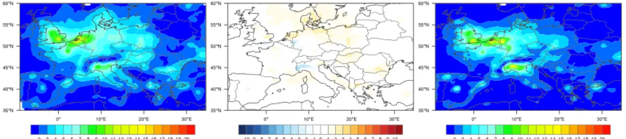
Fig. 2 Annual average of NO2VCD (unit:×1015molecules cm−2) over Europe: model (left), model-satellite (middle) and satellite (right)
the same framework, it was compared indirectly, as part of the GEMS-RAQ ensemble, to satellite-retrieved NO
2VCD (Huijnen et al. 2010) and, directly, with IASI tropospheric O3 columns (Zyryanov et al. 2012). Moreover, an upgraded version (2.0) was also verified in a 10-year experiment against surface data measurements as part of “megaCITY—
Zoom for the Environment” (CITYZEN) project (Colette et al. 2011), showing good skills particularly for NO
2sur- face concentration. This work focuses on two main aspects:
beside the analysis of the general behavior over Europe, one of the main interest is on the ability of the model to capture the NO
2content in the two most polluted European areas (PoValley and BeNeLux). In those highly populated regions, emissions of NOx change rapidly over very fine spatial scale (size of roads). This fact combined with the non-linear nature of NO
2makes the model resolution an important parameter. The evaluation of the effects of resolution change is the second objective of the present work.
Model simulations were performed throughout 2007 (the last year of the 10-year CITYZEN experiment) over Europe and the two main hot-spots therein: the Po Valley and the BeNeLux area. In addition, the area of Gibraltar is also con- sidered since, in the absence of other important pollutant sources, shipping emissions have a major role. Analyses will be discussed on annual and seasonal bases and the effect of resolution will be also addressed.
The manuscript is organised as follows: “Model description and experimental setup” gives an overview of
Fig. 3 Area average of NO2 VCD over Europe (see Fig.1) of the monthly mean tropospheric columns for 2007
BOLCHEM, including the experimental setup. “OMI data”
section provides a short description of the OMI satellite instrument, the retrieval algorithm and the tropospheric NO
2VCD characteristics. The spatial and temporal dis- tribution of simulated and observed NO
2VCD are dis- cussed in “Results and discussion” section, with reference to the effects of model resolution. Finally, in “Conclusions”
section, some conclusions are drawn.
Model description and experimental setup
The BOLCHEM model is an on-line coupled meteorology- composition model (Baklanov et al. 2014). Its meteorolog- ical component is the mesoscale meteorological BOlogna Limited Area Model (BOLAM)
3(Buzzi et al. 1994, 2003), whose dynamics is based on hydrostatic primitive equa- tions. The vertical grid uses a hybrid–terrain-following coordinate system, with variables distributed on a non- uniformly spaced staggered Lorenz (1960) grid. The hor- izontal discretisation uses geographical coordinates on an Arakawa C-grid. The time scheme is split-explicit, forward- backward for gravity modes. The weighted average flux (Billet and Toro 1997) advection scheme is implemented.
Lateral boundary conditions are imposed using a relaxation scheme in order to minimise the wave energy reflection.
As initial and lateral boundary conditions, use can be made of the data from the European Centre for Medium-range Weather Forecasts (ECMWF) or the global forecast sys- tem (NOAA-GFS.
4Hybrid model level data are directly interpolated on the BOLAM grid. Transport (advection and diffusion) of tracers (both passive and reactive) is performed on-line at each meteorological time-step using the mass- conservative WAF scheme (Maurizi et al. 2013) for advec- tion and a “physical” (second-order) horizontal-diffusion, with diffusion coefficient carefully estimated from exper- iments (Tampieri and Maurizi 2007) to account for unre- solved motion. Vertical diffusion is performed using a one- dimensional diffusion equation with a diffusion coefficient
3http://www.isac.cnr.it/∼dinamica/bolam/index.html
4http://www.ncdc.noaa.gov/data-access/model-data/model-datasets/
global-forcast-system-gfs
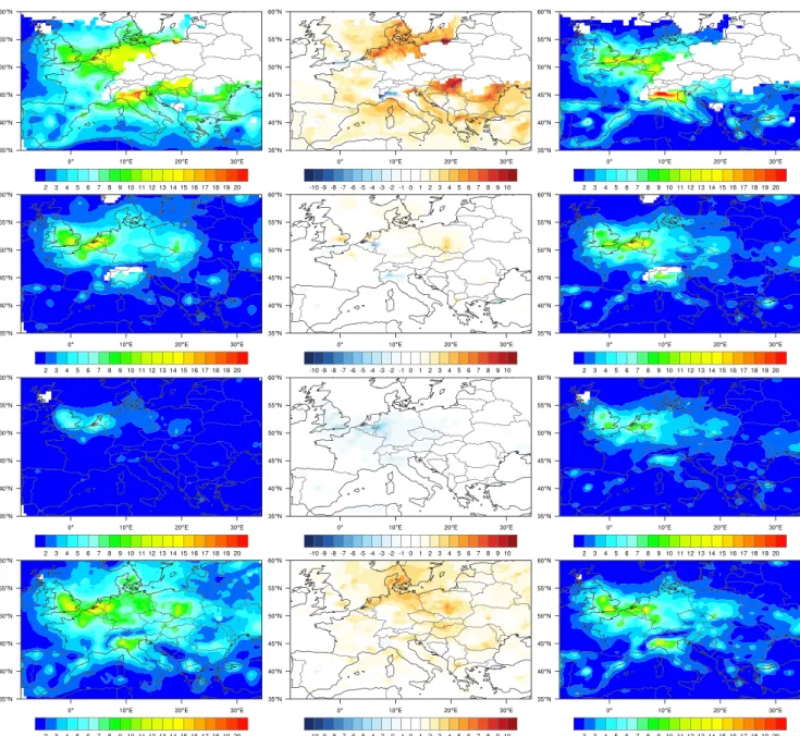
Fig. 4 Seasonal average of NO2VCD (Unit:×1015molecules cm−2) over Europe: model (left), model-satellite (middle) and satellite (right).
Seasons are winter, springer, summer and autumn fromtop to bottom, respectively.White areasfor model and satellite maps represent missing values
estimated by means of an E-l turbulence closure scheme (Zampieri et al. 2005). Dry deposition is computed through a resistance-analogy scheme and is provided as boundary condition to the vertical diffusion equation. Furthermore, vertical redistribution of tracers due to moist convection is parameterised consistently with the Kain-Frisch scheme used in the meteorological component for moist convection.
Transport of chemical species is performed in mass units, while gas chemistry is computed as mixing ratio. Physi- cal/chemical processes are treated separately for gas phase, aerosol classes and generic tracers (e.g. radioactive species, Saharan dust, etc.). The gas phase is treated using the
SAPRC90 mechanism modified to account for secondary organic aerosol precursors. The Aerosol component is mod- elled using AERO3. The model is included in the COST 728/732 model inventory,
5where more technical details can be found.
Model runs were performed over Europe with a horizon- tal resolution of 50 × 50 km
2, and in the two hot-spots (Po Valley and BeNeLux, as defined for the CITYZEN project)
5http://www.mi.uni-hamburg.de/List-classification-detail-view.6156.
0.html?&no cache=1&mvid=2621441
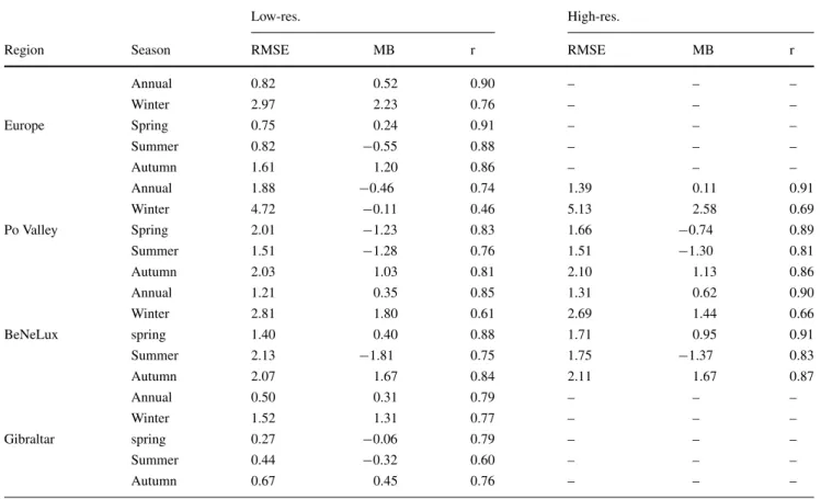
Table 1 Annual and seasonal statistical indices computed over Europe and selected regions
Low-res. High-res.
Region Season RMSE MB r RMSE MB r
Annual 0.82 0.52 0.90 – – –
Winter 2.97 2.23 0.76 – – –
Europe Spring 0.75 0.24 0.91 – – –
Summer 0.82 −0.55 0.88 – – –
Autumn 1.61 1.20 0.86 – – –
Annual 1.88 −0.46 0.74 1.39 0.11 0.91
Winter 4.72 −0.11 0.46 5.13 2.58 0.69
Po Valley Spring 2.01 −1.23 0.83 1.66 −0.74 0.89
Summer 1.51 −1.28 0.76 1.51 −1.30 0.81
Autumn 2.03 1.03 0.81 2.10 1.13 0.86
Annual 1.21 0.35 0.85 1.31 0.62 0.90
Winter 2.81 1.80 0.61 2.69 1.44 0.66
BeNeLux spring 1.40 0.40 0.88 1.71 0.95 0.91
Summer 2.13 −1.81 0.75 1.75 −1.37 0.83
Autumn 2.07 1.67 0.84 2.11 1.67 0.87
Annual 0.50 0.31 0.79 – – –
Winter 1.52 1.31 0.77 – – –
Gibraltar spring 0.27 −0.06 0.79 – – –
Summer 0.44 −0.32 0.60 – – –
Autumn 0.67 0.45 0.76 – – –
Units for RMSE and MB is×1015molecules cm−2
at 10 × 10 km
2, with 40 and 20 vertical sigma-hybrid lev- els for meteorology and chemistry, respectively. The top of chemistry domain is approximately at 500 ˜hPa. Equa- tions are integrated on a rotated-pole coordinate system with a time-step of 400 s. Boundary conditions for the mete- orology were supplied by ECMWF; for tracers, gas and aerosols, climatological boundary conditions were used for the European domain. For the two hot-spots, the boundary conditions were taken from the simulation of the European domain every hour. Emissions prepared for the CITYZEN project by INERIS
6(Colette et al. 2011) were used. This emission dataset was prepared for the 10-year experiment using on official European Monitoring and Evaluation Pro- gramme (EMEP) data (with resolution of 50 × 50 km
2) and spatial distribution based on the GEMS-RAQ emissions (at 10 × 10-km
2resolution). This emission dataset is affected by the typical uncertainty of similar datasets like, e.g. the one prepared with the same spatial resolution in the frame of the “Monitoring Atmospheric Composition and Climate (MACC)”.
76http://www.ineris.fr/
7https://www.gmes-atmosphere.eu/
OMI data
The ozone monitoring instrument (OMI) flies on the NASA/EOS-AURA satellite, providing the possibility of global measurements of the atmospheric NO
2VCDs via measuring direct and backscattered sunlight in the ultraviolet-visible range from 270 to 500 nm (Levelt et al.
2006). The instrument was launched in July 2004 with a Sun-synchronous polar orbit crossing the equator at 13:30 local time. The OMI satellite observes the atmosphere with a spatial resolution of 13 km along track and 24 km across track in the nadir view, with a global coverage in 1 day.
The OMI tropospheric NO
2level 2 data (Dutch OMI NO2, DOMINO v2.0) used in this study for Europe in 2007 are obtained from Tropospheric Emission Monitoring Internet Service (TEMIS) project.
8According to Boersma et al. (2007) and Boersma et al. (2011), the NO
2DOMINO retrieval algorithm is based on three main steps: (i) obtain the NO
2slant column density from OMI reflectance spectra, using differential optical absorption spectroscopy (DOAS);
(ii) estimate and separate the stratospheric and tropospheric contributions to the slant column; and (iii) convert the remaining tropospheric slant column to a vertical column
8http://www.temis.nl
Fig. 5 Annual average of NO2VCD (unit:×1015molecules cm−2) over Po Valley: model (left), model-satellite (middle) and satellite (right), for low-resolution (top) and high-resolution (bottom)
using the tropospheric air mass factor (AMF). Moreover, only satellite measurements with cloud fractions less than 50 % are included in the satellite dataset (van der A et al.
2008).
Further information on the DOMINO v2.0 retrieval algo- rithm is available in Boersma et al. (2011) and the latest updates can be found in the DOMINO product specification document.
9Results and discussion
Comparison of model and satellite data were performed for the whole of Europe with focus on selected regions (Fig. 1) at two different resolutions: 50 × 50 and 10 × 10 km
2. The analysis was performed on annual, seasonal and monthly basis. For the seasonal analysis, conventional sea- sons were used: winter (January, February, December), spring (March, April, May), summer (June, July, August) and autumn (September, October, November). Notice that winter is based on three months of the same year.
Satellite level 2 swath files were regridded on daily basis using the WHIPS
10tool, onto common analysis grids with the same model resolution: 50 × 50 km
2in the Europe and Gibraltar cases and 10 × 10 km
2for the Po Valley and BeNeLux. In the regridding procedure, data with cloud cover larger than 0.2, surface albedo larger than 0.3 and solar zenith angle larger than 85
◦are discarded. This filter produces a mask of valid measurements that is applied also to model results to make the satellite and model datasets fully consistent.
The model output was sampled at the same satellite overpass time over Europe (13:30 UTC). The modelled VCD was computed using the averaging kernel (AK) cor- rected by the ratio between the total and the tropospheric AMF (Eskes and Boersma 2003). Because model simula- tion reach a height of about 500 hPa, the upper NO
2content
9http://www.temis.nl/docs/OMI NO2 HE5 2.0 2011.pdf
10http://www.sage.wisc.edu/download/WHIPS/WHIPS.html
was extrapolated linearly from the upper model value to zero at the tropopause (where O3 exceeds 150 ppb which, above Europe, corresponds to about 200 hPa) (Huijnen et al.
2010). The linear extrapolation to zero is well-supported by the climatological fields used in CITYZEN (Colette et al.
2011) and the analysis about the application of the AK found in Huijnen et al. (2010).
Low resolution: Europe and selected regions
Results of the analysis of annual and seasonal tropospheric NO
2VCD as simulated by the BOLCHEM model and observed by OMI over Europe are reported in Figs. 2, 3 and 4 and Table 1.
In this section, the main features are analysed for the whole Europe and selected regions: Po Valley, BeNeLux and Gibraltar (Fig. 1), at coarse resolution. Yearly and seasonal analyses are also discussed. Figure 2 shows the annual spatial distribution of NO
2VCD over Europe of the DOMINO product (right) and the model output (left), along with the difference between them (middle).
At a first glance, a good agreement between model and satellite can be noticed (Fig. 2). Similar features are displayed by predicted and simulated VCD over highly pol- luted regions (the Po Valley and BeNeLux hot-spots and the largest European cities; Paris, London, Madrid, Barcelona, Rome, etc.). Generally speaking, the model presents a background higher and smoother than the satellite, mainly in winter and autumn. The model underestimates VCD over some large cities (Cologne, Istanbul, Madrid, Milan, Turin), while displaying a weak overestimation over oth- ers (Athens, Barcelona, London, Marseilles, Paris, Rome) and a general overestimation over the Netherlands. Look- ing at the two hot-spots, it can be seen that VCD in the Po Valley is underestimated by the model, while the behav- ior for BeNeLux is less uniform, displaying both over- and under-estimations.
Model underestimation observed in the Po Valley
(Fig. 5 upper panel) can be related to the complex
Alpine topography and its impact on the data retrieval
Fig. 6 Annual average of NO2VCD (unit:×1015molecules cm−2) over BeNeLux: model (left), model-satellite (middle) and satellite (right), for low-resolution (top) and high-resolution (bottom)
(Schaub et al. 2007; Zhou et al. 2009), in addition to inaccu- racies in the emissions inventory. In contrast to this seasonal change observed over Europe, the underestimation in the Po Valley is relatively uniform over time.
In the BeNeLux area (Fig. 6 upper panel), a mixture of slight over- and under-estimation of VCD is observed. The satellite map presents two maxima while the model only has one, missing the maximum observed over the Cologne area.
Fig. 7 Scatter plots between BOLCHEM and OMI NO2
columns:aEurope,bGibraltar at low-resolution,cPo Valley anddBeNeLux at high- resolution.ris the correlation coefficient andSis the slope
Fig. 8 Annual average of NO2VCD (unit:×1015molecules cm−2) over Gibraltar:left(model),centre(difference: model-satellite) andright (satellite)
This is likely to be caused by inaccuracies in the emission database. The effect of finer resolution will be discussed in
“High resolution over Po Valley” and “High resolution over BeNeLux” sections.
Looking at the south-west part of the domain, the ship tracks are more visible in the model map, espe- cially for the Gibraltar area, while the satellite map shows some signs of the North African big cities and indus- trial areas (e.g. Algiers, Oran, S’kikda, Tunis) that are not visible in the model map, clearly reflecting the lack of emissions in the southern part of the simulated domain (North Africa).
Annual and seasonal root mean square error (RMSE), mean bias (MB) and correlation (r) were computed for Europe and specific regions (see Table 1). The spatial cor- relation of the annual maps between OMI DOMINO v2.0 and BOLCHEM is 0.90. The value of the above correlation coefficient is high compared to typical values found in the literature.
Seasonal average maps of VCD are presented and com- pared in Fig. 4, and a statistical analysis is reported in Table 1. Figure 4 is organised in the same way as Fig. 2:
model results in the left panel, satellite observations in the right panel and differences in the middle.
Figure 4 shows a good agreement between model and satellite data with hot-spots and urban polluted patterns similarly distributed in spring and summer, with spatial cor- relation coefficients (Table 1) of 0.91 and 0.88, respectively, and small RMSE and MB.
In autumn and winter, there is a general overestima- tion more pronounced near areas were missing values are present, possibly highlighting some efficiency problem in
the filtering procedure. In particular, the large areas of miss- ing values observed in north-east Europe result from the combination of cloudiness and high surface albedo due to snow cover. Selecting thresholds higher than the “standard ones” would enlarge the missing data areas, thus remov- ing the large overestimation in winter over, e.g. Hungary.
Underestimation is observed in some spots like Madrid, Frankfurt and the English Channel, with a strong maximum in the Po Valley in which, however, high overestimation in winter is observed in pixels adjacent to missing data areas and can be partly remove with more strict thresholds.
Despite this, the spatial correlation over Europe is still high (0.86) in autumn and acceptable in winter (0.76).
Looking at specific regions, it is observed that (Table 1) the correlation is moderately higher for BeNeLux than for the Po Valley and Gibraltar. The correlation is good in the Po Valley, except in winter when the area is frequently covered by clouds. Gibraltar presents also good correlation, except in summer, in contrast to the lowest value observed in winter in the other two regions. Concerning the MB, the annual val- ues, which differ for each area, are unevenly distributed over time, with typically small negative values in spring/summer and high positive values in winter and autumn, except for the Po Valley where even winter values are very small, due to a compensation between the underestimation in the west and the overestimation in the east.
Figure 7 shows the scatter-plots between the BOLCHEM simulated and the OMI retrieved tropospheric NO
2VCD over Europe, Gibraltar for low-resolution (50 × 50 km
2) and the Po Valley, BeNeLux for high-resolution (10 × 10 km
2).
For Europe, most of the data is above the 1:1 line, which reflects the already noted annual overestimation, with the
Fig. 9 Area average of NO2
VCD over Gibraltar (see Fig.1) of the monthly mean
tropospheric columns for 2007 (left panel). In theright panel, relative differences are shown
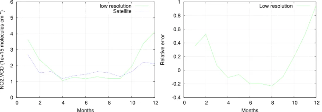
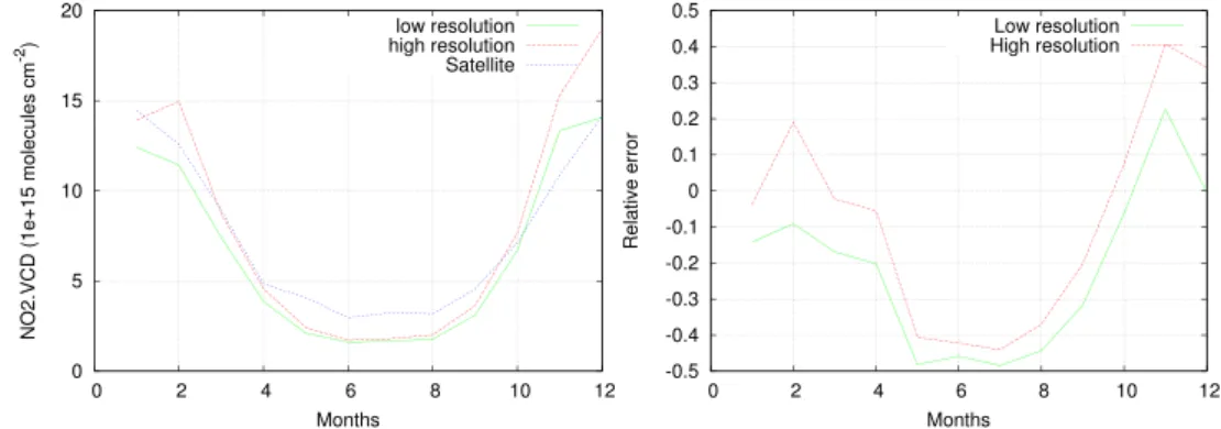
Fig. 10 Area average of NO2
VCD over Po Valley (see Fig.1) of the monthly mean
tropospheric columns for 2007 with different model resolutions (left panel). In theright panel, relative differences are shown
subset of data for north-eastern Europe clearly identifiable, and well above the regression line. Clear overestimation is also apparent in the BeNeLux and Gibraltar scatter-plots.
In the Po Valley, the scatter-plot displays an overestimation for small values and an underestimation for the highest end of the VCD range, which corresponds to the model under- estimation over the highly polluted Milan area observed in Fig. 5.
Despite Gibraltar was not the focus of the CITYZEN project, model simulation cover also that region which is highly affected by shipping emission. Although the domain is located near the boundary and is probably influenced by the boundary conditions, which in the present simulations are climatological, the area is mostly affected by shipping emissions which are present in the emission dataset used for the model simulations and, therefore, the analysis of results can provide useful information.
Figure 8 displays NO
2VCDs for the Gibraltar region, which are lower than in the other selected regions, this area not being affected by very large emissions. VCD values range from 100 to 400 × 10
15molecules cm
−2dur- ing the whole of 2007 for both model and satellite. The lack of emissions in North Africa, already observed when analysing results for Europe, do not seem to play a major role. In general, the most influential sources in the area seem to be the southern Spain cities and shipping emissions.
The model predicts higher values of VCD than the satellite, in agreement with previous findings where a strong model overestimation is observed over the sea in correspondence to shipping routes (Im et al. 2014).
Looking at the annual cycle (Fig. 9), during spring and summer, there is a small difference between the spa- tial average of OMI measured and model simulated NO
2VCDs, ranging from 5 to 8 % in spring and is 18 % in summer. In winter and autumn, a model overestimation is observed.
A more detailed analysis is found in Table 1. The sta- tistical analysis displays a small magnitude of the Mean Bias in spring and summer with − 0.06 and − 0.32 × 10
15molecules cm
−2, respectively. It is worth noting that an unusual seasonal spatial correlation (high in winter and small in summer) appears in the seasonal statistical analysis (Table 1) in contrast to what happens for the other selected regions. It must be borne in mind, however, that this region is not only less affected by large emissions but also presents low cloudiness.
High resolution over Po Valley
In this section, we present a comparison of DOMINO v2.0 with coarse- and high-resolution simulated tropospheric NO
2VCDs from the BOLCHEM model over the Po Valley
Fig. 11 Area average of NO2
VCD over BeNeLux (see Fig.1) of the monthly mean
tropospheric columns for year 2007 with different model resolutions (left panel). In the right panel, relative differences are shown
changes significantly with resolution, are discerned in both the model and satellite such as the high NO
2amounts for Milan and low amounts over the Alps and Appenines.
Model overestimation in Liguria (west of Genoa) and over the Ligurian Sea is observed. Concerning Liguria, the over- estimation is possibly caused by the poor representation of the Maritime Alps barrier between the Po Valley and Ligurian Sea in the meteorological model, allowing for some spurious transport from the more polluted Po Valley area towards the sea. Underestimation is generally reduced except over Milan. The annual spatial correlation is r = 0.91 (Table 1), a clear improvement with respect to the low- resolution correlation (r = 0.74, Table 1).
Figure 10a presents the time series of the monthly mean VCD from OMI satellite measurements and model- predicted values averaged over the Po Valley region. The model is quite successful in capturing the VCD annual cycle, with small absolute differences, except in winter.
Looking at the relative errors, the high-resolution simulated VCD values are larger than the OMI ones by 0 to 35 % during winter time. In summer, there is an underestimation of more than 40 %, enhanced by the low absolute values of VCD. A different picture emerges at coarse-resolution, which displays a better agreement in winter and autumn, with relative errors ranging from 0 to − 0.15 in winter and
− 0.43 to − 0.48 in summer. The bulk effect of increasing resolution is to increase the simulated NO
2VCD by 5 to 30 % for the whole year. This seems to be effective in reduc- ing the error mainly in summer, when the photochemical reactions are dominant.
A good correlation is found for the Po Valley for all sea- sons in the high-resolution experiment (Table 1), higher than those found for the low-resolution experiment (Table 1) with a larger improvement in winter in which the lowest value is found for both resolutions. The mean bias shows variations with season for high-resolution, with the greatest value in winter (2.58 × 10
15molecules cm
−2). This highlights the better agreement between model and satellite observations in cloud-free conditions.
The seasonal statistical analysis in Table 1 demonstrates the positive effect of the high-resolution model in spring and summer and the negative effect during winter and autumn. Table 1 displays high RMSE in winter at both res- olutions. The magnitude of the mean bias decreases with high-resolution from 1.23 to 0.74 × 10
15molecules cm
−2in spring, whereas the same parameter increases from 0.11, 1.03 to 2.58 and 1.13 × 10
15molecules cm
−2for winter and autumn, respectively.
region, the spatial distribution (maxima and minima loca- tions) of NO
2VCDs is not very well captured by the model at low resolutions because model only presents a maxi- mum of VCD while satellites displays two. This picture is slightly improved by the high-resolution that displays a secondary maximum in correspondence to the Rhine-Ruhr area, the main center of European steel production and the big inland port of Duisburg. However, VCD in this area is slightly underestimated at both resolution with a more pro- nounced effect at low-resolution (Fig. 6b, e). On the other end, high-resolution simulation displays larger overestima- tion in areas not affected by large emissions. Moreover, as a general comment, the model always displays a smoothly distributed VCD, unlike the satellite VCD, which is more concentrated in areas of high emissions.
In contrast to the results for the sea in other areas, a large NO
2VCD is observed by both model and satellite between the UK and Belgium, and more generally (see Figs. 2 and 4) in the whole English Channel and south of the North Sea.
This is possibly because, in addition to shipping emissions, a large contribution to the high level of pollution comes from the highly polluted adjacent land areas.
The spatial correlation is improved in high-resolution simulation (Table 1) uniformly over the seasons. The sta- tistical analysis shows that the high-resolution model has positive effects during summer time in agreement with Yamaji et al. (2014). This is more evident in this region than in the Po Valley. According to the relative error plot (Fig. 11b), the high-resolution simulation reduces the error between simulated and measured VCDs by 29 % in summer.
As shown in Table 1, MB displays strong seasonal vari- ations. The RMSE varies slightly, displaying higher values in winter and autumn and lower in spring and summer with only slight variations between high and low resolution.
Conclusions
Simulations of atmospheric pollutants for the year 2007 over Europe with a focus on hot-spots at higher resolu- tion were analysed in order to verify the ability of the BOLCHEM model to reproduce the NO
2vertical column density retrieved from OMI (DOMINO v2.0 product from TEMIS). The analysis was performed on an annual, sea- sonal and monthly basis.
The model turned out to perform well, with statistical
parameters in line with those found in the literature for other
comparison experiments (e.g. Han et al. 2011; Zyrichidou
et al. 2013, Im et al. 2014) with particularly high values of the correlation coefficient. Analysis on a seasonal basis confirms the good BOLCHEM performances, while reveal- ing a difference between the “warm” and “cold” seasons:
in spring and summer, performances are usually better than in winter. However, the statistical significance of winter satellite data is reduced by the low number of observations caused by the presence of clouds and also by increased surface albedo due to snow cover.
Performances in the low polluted region of Gibraltar, where one of the main sources is shipping emissions, is relatively good despite the missing emissions from North Africa and also possibly by the boundary conditions can have a negative influence. At variance with the other anal- ysed regions, the spatial correlation is higher in winter and lower in summer when photochemistry is active.
The analysis of high-resolution simulations over the two main European hot-spots reveals that high-resolution is more effective in the Po Valley, where it increases the spatial correlation more than in the BeNeLux. However, the effect on the other scores is less clear. The increase of correlation is an important signature of the impact of non-linearities in photochemistry. The observed differences between the Po Valley and BeNeLux in response to increasing resolution can be explained by the large differences in meteorology. In BeNeLux, where wind is typically stronger than in the Po Valley and causes more mixing which, in turn, is expected to make the concentrations less dependent on local emis- sions, high resolution does not seem to increase the model prediction. This is confirmed by the differences observed in the seasonal analysis, which shows a positive impact in
“warm” seasons, where photochemistry is more effective, and negative in “cold” ones.
An extended analysis, also involving surface data and ground-based remote sensing with profiling capabilities, would be an interesting step towards understanding both satellite data reliability and model performances with regard to the effect of vertical distribution, which is known to be an important issue for both models and satellites.
Acknowledgments We acknowledge the free use of tropospheric NO2column data from the OMI sensor fromwww.temis.nl. The software used for the production of this article (model development, model run, data analysis, graphics, typesetting) is Free Software. The authors would like to thank the whole free software community, the Free Software Foundation11and, in particular, the Debian Project.12 This is part of the PhD research project of Lakhdar Aidaoui supported by the Ministry of High Education and Scientific Research of Alge- ria. The authors would like to thank Dr. Bianca Maria Dinelli and Dr.
Enrico Arnone for helpful discussion on the analysis of satellite data.
The research leading to these results has received funding from the European Unions Seventh Framework Programme (FP7/2007-2013) under grant agreement no. 212095 (CityZen).
11http://www.fsf.org
12http://www.debian.org
References
Ashmore MR (2005) Assessing the future global impacts of ozone on vegetation. Plant Cell and Environment 28(8):949–964.
doi:10.1111/j.1365-3040.2005.01341.x
Baklanov A, Schlunzen K, Suppan P, Baldasano J, Brunner D, Aksoyoglu S, Carmichael G, Douros J, Flemming J, Forkel R, Galmarini S, Gauss M, Grell G, Hirtl M, Joffre S, Jorba O, Kaas E, Kaasik M, Kallos G, Kong X, Korsholm U, Kurganskiy A, Kushta J, Lohmann U, Mahura A, Manders-Groot A, Maurizi A, Moussiopoulos N, Rao ST, Savage N, Seigneur C, Sokhi RS, Solazzo E, Solomos S, Sørensen B, Tsegas G, Vignati E, Vogel B, Zhang Y (2014) Online coupled regional meteorology chemistry models in Europe: current status and prospects. Atmos Chem Phys 14(1):317–398. doi:10.5194/acp-14-317-2014
Billet SJ, Toro EF (1997) On WAF-Type schemes for multidimen- sional hyperbolic conservation laws. J Comput Phys 130:1–
24
Boersma KF, Eskes HJ, Veefkind JP, Brinksma EJ, van der ARJ, Sneep M, van den Oord GHJ, Levelt PF, Stammes P, Gleason JF, Bucsela EJ (2007) Near-real time retrieval of tropospheric NO2 from OMI.
Atmos Chem Phys 7:2103–2118
Boersma KF, Eskes HJ, Dirksen RJ, van der ARJ, Veefkind JP, Stammes P, Huijnen V, Kleipool QL, Sneep M, Claas J, Leitao J, Richter A, Zhou Y, Brunner D (2011) An improved tropo- spheric NO2 column retrieval algorithm for the Ozone Monitoring Instrument. Atmos Meas Tech 4:1905–1928
Butenschoen M, Maurizi A, Tampieri F (2003) Bolchem 0.9: A 3d pre- diction model of the meteorology and the chemical composition of the atmosphere. Tech. rep. CNR-ISAC, Italy
Buzzi A, Fantini M, Malguzzi P, Nerozzi P (1994) Validation of a Limited Area Model in cases of Mediterranean cyclogenesis: sur- face fields and precipitation scores. Meteorol Atmos Phys 53:137–
153
Buzzi A, D’Isidoro M, Davolio S (2003) A case-study of an orographic cyclone south of the Alps during the MAP SOP. Q J Roy Meteor Soc 129–591:1795–1818
Chen R, Samoli E, Wong CM, Huang W, Wang Z, Chen B, Kan H (2012) Associations between short-term exposure to nitrogen dioxide and mortality in 17 Chinese cities: The China Air Pol- lution and Health Effects Study (CAPES). Environ Int 45:32–
38
Colette A, Granier C, Hodnebrog Ø, Jakobs H, Maurizi A, Nyiri A, Bessagnet B, D’Angiola A, D’Isidoro M, Gauss M, Meleux F, Memmesheimer M, Mieville A, Rouil L, Russo F, Solberg S, Stordal F, Tampieri F (2011) Air quality trends in Europe over the past decade: a first multi-model assessment. Atmos Chem Phys 11:11,657–11,678. doi:10.5194/acpd-11-19029-2011
Colette A, Granier C, Hodnebrog Ø, Jakobs H, Maurizi A, Nyiri A, Rao S, Amann M, Bessagnet B, DAngiola A, Gauss M, Heyes C, Klimont Z, Meleux F, Memmesheimer M, Mieville A, Rouil L, Russo F, Schucht S, Simpson D, Stordal F, Tampieri F, Vrac M (2012) Future air quality in Europe: a multi-model assessment of projected exposure to ozone. Atmos Chem Phys 12(21):10,613–
10,630. doi:10.5194/acp-12-10613-2012
Curier RL, Kranenburg R, Segers AJ, Timmermans RMA, Schaap M (2014) Synergistic use of OMI NO2 tropospheric columns and LOTOSEUROS to evaluate the NOx emission trends across Europe. Remote Sens Environ 149:58–69
Eskes HJ, Boersma KF (2003) Averaging kernels for doas total- column satellite retrievals. Atmos Chem Phys 3:1285–1291.
doi:10.5194/acp-3-1285-2003, 2003
Fuhrer J, Skarby L, Ashmore MR (1997) Critical levels for ozone effects on vegetation in Europe. Environ Pollut 97(1–2):91–106.
doi:10.1016/S0269-7491(97)00067-5
Huang J, Zhou C, Lee X, Bao Y, Zhao X, Fung J, Richter A, Liu X, Zheng Y (2013) The effects of rapid urbanization on the levels in tropospheric nitrogen dioxide and ozone over East China. Atmos Environ 77:558–567
Huijnen V, Eskes HJ, Poupkou A, Elbern H, Boersma KF, Foret G, Sofiev M, Valdebenito A, Flemming J, Stein O, Gross A, Robertson L, D’Isidoro M, Kioutsioukis I, Friese E, Amstrup B, Bergstrom R, Strunk A, Vira J, Zyryanov D, Maurizi A, Melas D, Peuch VH, Zerefos C (2010) Comparison of OMI NO2 tro- pospheric columns with an ensemble of global and European regional air quality models. Atmos Chem Phys 10:3273–3296 Im U, Daskalakis N, Markakis K, Vrekoussis M, Hjorth J,
Myriokefalitakis S, Gerasopoulos E, Kouvarakis G, Richter A, Burrows J, Pozzoli L, Unal A, Kindap T, Kanakidou M (2014) Simulated air quality and pollutant budgets over Europe in 2008.
Sci Total Environ 470–471:270–281
Kukkonen J, Olsson T, Schultz DM, Baklanov A, Klein T, Miranda AI, Monteiro A, Hirtl M, Tarvainen V, Boy M, Peuch VH, Poupkou A, Kioutsioukis I, Finardi S, Sofiev M, Sokhi R, Lehtinen KEJ, Karatzas K, San Jos˙e R, Astitha M, Kallos G, Schaap M, Reimer E, Jakobs H, Eben K (2012) A review of operational, regional-scale, chemical weather forecasting models in Europe. Atmos Chem Phys 12(1):1–87. doi:10.5194/acp-12-1-2012
Lalitaporn P, Kurata G, Matsuoka Y, Thongboonchoo N, Surapipith V (2013) Long-term analysis of no 2, co, and aod seasonal variabil- ity using satellite observations over asia and intercomparison with emission inventories and model. Air Qual Atmos Health 6:655–
672
Latza U, Gerdes S, Baur X (2009) Effects of nitrogen dioxide on human health: systematic review of experimental and epidemi- ological studies conducted between 2002 and 2006. Int J Hyg Environ Health 212:271–287
Levelt PF, van denOord GHJ, Dobber MR, Malkki A, Visser H, de Vries J, Stammes P, Lundell JOV, Saari H (2006) The ozone mon- itoring instrument. IEEE Trans Geosci Remote Sens 44:1093–
1100
Lorenz EN (1960) Energy and numerical weather prediction. Tellus 12:364–373
Maurizi A, D’Isidoro M, Mircea M (2010) BOLCHEM, an inte- grated system for atmospheric dynamics and composition. In:
Baklanov A, Mahura A, Sokhi R (eds) Integrated systems of meso- meteorological and chemical transport models, vol 8. Springer, p 186
Maurizi A, Russo F, Tampieri F (2013) Local vs. external contribution to the budget of pollutants in the Po Valley (Italy) hot spot. Sci Total Environ 458–460:459–465
Mircea M, D’Isidoro M, Maurizi A, Vitali L, Monforti F, Zanini G, Tampieri F (2008) A comprehensive performance evalua- tion of the air quality model BOLCHEM to reproduce the ozone concentrations over Italy. Atmos Environ 42(6):1169–
1185
Monks PS, Granier C, Fuzzi S, Stohl A, Williams ML, Akimoto H, Amann M, Baklanov A, Baltensperger U, Bey I, Blake N, Blake RS, Carslaw K, Cooper OR, Dentener F, Fowler D, Fragkou E, Frost GJ, Generoso S, Ginoux P, Grewe V, Guenther A, Hansson, HC, Henne S, Hjorth J, Hofzumahaus A, Huntrieser H, Isaksen ISA, Jenkin ME, Kaiser J, Kanakidou M, Klimont Z,
Atmospheric composition change global and regional air quality.
Atmos Environ 43:5268–5350
Richter A, Burrows JP (2002) Tropospheric NO2 for GOME measure- ments. Adv Space Res 29(11):1673–1683
Richter A, Burrows JP, Nuß H, Granier C, Niemeier U (2005) Increase in tropospheric nitrogen dioxide over China observed from space.
Nature 437:129–132
Schaub D, Brunner D, Boersma KF, Keller J, Folini D, Buchmann B, Berresheim H, Staehelin J (2007) SCIAMACHY tropospheric NO2 over Switzerland: estimates of NOx lifetimes and impact of the complex Alpine topography on the retrieval. Atmos Chem Phys 7:5971–5987
Solomon S, Portmann RW, Sanders RW, Daniel JS (1999) On the role of nitrogen dioxide in the absorption of solar radiation. J Geophys Res 104:12,047–12,058
Tampieri F, Maurizi A (2007) Evaluation of the dispersion coeffi- cient for numerical simulations of tropospheric transport. Nuovo Cimento C 30:395–406
van der A RJ, Eskes HJ, Boersma KF, van Noije TPC, van Roozendael M, De Smedt I, Peters DHMU, Meijer EW (2008) Trends, sea- sonal variability and dominant NOx source derived from a ten year record of NO2 measured from space. J Geophys Res 113:D04,302.
doi:10.1029/2007JD009021
Wang B, Chen Z (2013) An intercomparison of satellite-derived ground-level NO2 concentrations with GMSMB modeling results and in-situ measurements - A North American study. Environ Pollut 181:172–181
Yamaji K, Ikeda K, Irie H, Kurokawa J, Ohara T (2014) Influence of model grid resolution on no 2 vertical column densities over east asia. J Air Waste Manag Assoc 64:436–444
Zampieri M, Malguzzi P, Buzzi A (2005) Sensitivity of quantitative precipitation forecasts to boundary layer parameterization: a flash flood case study in the western mediterranean. Nat Hazards Earth Syst Sci 5:603–612
Zhou Y, Brunner D, Boersma KF, Dirksen R, Wang P (2009) An improved tropospheric NO2 retrieval for OMI observations in the vicinity of mountainous terrain. Atmos Meas Tech 2:401–
416
Zyrichidou I, Koukouli ME, Balis D, Katragkou E, Melas D, Poupkou A, Kioutsioukis I, van der AR, Boersma KF, van Roozendael M, Richter A (2009) Satellite observations and model simulations of tropospheric NO2 columns over south-eastern Europe. Atmos Chem Phys 9:6119–6134
Zyrichidou I, Koukouli ME, Balis DS, Kioutsioukis I, Poupkou A, Katragkou E, Melas D, Boersma KF, van Roozendael M (2013) Evaluation of high resolution simulated and OMI retrieved tropo- spheric NO2 column densities over Southeastern Europe. Atmos Res 122:55–66
Zyryanov D, Foret G, Eremko M, Beekmann M, Cammas JP, D’Isidoro M, Elbern H, Flemming J, Friese E, Kioutsioukis I, Maurizi A, Melas D, Meleux F, Menut L, Moinat P, Peuch VH, Poupkou A, Razinger M, Schultz M, Stein O, Suttie M, Valdebenito A, Zerefos C, Dufour G, Bergametti G, Flaud JM (2012) 3D evaluation of tropospheric ozone simulations by an ensemble of regional Chemistry Transport Model. Atmos Chem Phys 12:3219–3240. doi:10.5194/acp-12-3219-2012