HAL Id: hal-03135825
https://hal.archives-ouvertes.fr/hal-03135825
Submitted on 9 Feb 2021
HAL is a multi-disciplinary open access
archive for the deposit and dissemination of
sci-entific research documents, whether they are
pub-lished or not. The documents may come from
teaching and research institutions in France or
abroad, or from public or private research centers.
L’archive ouverte pluridisciplinaire HAL, est
destinée au dépôt et à la diffusion de documents
scientifiques de niveau recherche, publiés ou non,
émanant des établissements d’enseignement et de
recherche français ou étrangers, des laboratoires
publics ou privés.
Contrasting tectonically driven exhumation and incision
patterns, western versus central Nepal Himalaya
Peter van der Beek, Camille Litty, Mallory Baudin, Jonathan Mercier, Xavier
Robert, Elizabeth Hardwick
To cite this version:
Peter van der Beek, Camille Litty, Mallory Baudin, Jonathan Mercier, Xavier Robert, et al..
Con-trasting tectonically driven exhumation and incision patterns, western versus central Nepal Himalaya.
Geology, Geological Society of America, 2016, 44 (4), pp.327-330. �10.1130/G37579.1�. �hal-03135825�
327
Contrasting tectonically driven exhumation and incision patterns,
western versus central Nepal Himalaya
Peter van der Beek, Camille Litty*, Mallory Baudin, Jonathan Mercier, Xavier Robert, and Elizabeth Hardwick
Université Grenoble Alpes, Institut des Sciences de la Terre (ISTerre), CS40700, 38058 Grenoble, FranceABSTRACT
Although the Himalayan range is classically presented as cylindrical along strike, segmen-tation of the range in terms of structure, topography, precipisegmen-tation, and erosion patterns is becoming widely recognized. The potential climatic or tectonic controls on these lateral varia-tions remain controversial. Thermokinematic models predict that the geometry of the main Himalayan detachment controls the kinematics, exhumation, and topography of the orogen: where the detachment includes a major crustal ramp, the topography shows a steep gradient that focuses orographic precipitation and exhumation, whereas the topography is gentler and exhumation less focused above a flatter detachment. We test this prediction by comparing the patterns of river incision (specific stream power) and long-term exhumation (from apatite fis-sion track thermochronology) in central Nepal, where a major crustal ramp has been imaged by geophysical methods, with new exploratory data from the remote Karnali River transect in western Nepal, where a ramp is predicted to be absent or minor. Our results show that both exhumation rates and river incision capacity are significantly higher and focused on the crustal ramp in central Nepal, whereas they are lower and the pattern is more diffuse in west-ern Nepal. These differences support a model in which lateral variations in topography and exhumation are controlled by variations in the geometry of the detachment, and imply that along-strike climatic variations in the Himalaya respond to tectonics rather than driving it. INTRODUCTION
The Himalaya has become a key natural lab-oratory for studying the interactions between tectonics, climate, and erosional processes (e.g., Burbank et al., 2003; Wobus et al., 2003; Grujic et al., 2006; Godard et al., 2014). Although the range is commonly presented as cylindrical along strike, it is characterized by significant lateral variations in geological structure (e.g., Yin, 2006), topography (Duncan et al., 2003; Bookhagen and Burbank, 2006), precipitation (Bookhagen and Burbank, 2006, 2010), and exhumation rates (Robert et al., 2011; Thiede and Ehlers, 2013). In particular, segments of the belt that are characterized by a pronounced topographic step between the Lesser and Greater Himalaya, associated with a peak in precipita-tion and focused exhumaprecipita-tion, alternate with segments where the topography increases more linearly to the north, precipitation peaks at lower elevations, and exhumation rates are lower (Duncan et al., 2003; Bookhagen and Burbank, 2006; Robert et al., 2011; Thiede and Ehlers, 2013). The potential climatic or tectonic controls on these spatially variable topographic, precipitation, and exhumation patterns have been widely discussed in recent years but remain controversial (e.g., Wobus et al., 2003; Bollinger et al., 2006; Herman et al., 2010).
In earlier work (see Robert et al., 2009, 2011) we combined apatite fission-track (AFT) ther-mochronology and numerical thermokinematic modeling to suggest that (1) the steep gradi-ent in topography that focuses exhumation and oro graphic precipitation in the central Nepal Himalaya (e.g., Wobus et al., 2003) is sustained by active rock uplift above a major mid-crustal ramp in the Main Himalayan Thrust (MHT; the inter face along which the Indian plate under-thrusts the Himalaya), as invoked by structural studies (cf. Bollinger et al., 2006; Elliott et al., 2016) and imaged by seismic methods (Schulte-Pelkum et al., 2005; Nábelek et al., 2009); and (2) lateral variations in the geometry of the MHT, in particular the presence or absence of a major mid-crustal ramp, may explain the observed topo-graphic and exhumation patterns of the orogen. A growing body of work has corroborated the strong control of the geometry of the plate interface on Himalayan kinematics and patterns of denudation rates, from instantaneous to million-year time scales (Brewer and Burbank, 2006; Herman et al., 2010; Grandin et al., 2012; Coutand et al., 2014; Godard et al., 2014; Scherler et al., 2014; Le Roux-Mallouf et al., 2015; Elliott et al., 2016). However, most of these studies focused on single transects across the orogen, without addressing potential along-strike variations.
Here we test this model by comparing erosion patterns in the Karnali River catchment, in west-ern Nepal, to those in the Trisuli River catchment in central Nepal. Topographic and geodetic data point to an abrupt change in the geometry of the MHT between western and central Nepal, with the major mid-crustal ramp disappearing toward the west (Berger et al., 2004; Harvey et al., 2015). We combine new AFT data from the Karnali catchment with an analysis of erosional stream power (a proxy for incision capacity) of both rivers to determine whether this inferred major difference in the geometry of the plate interface is reflected in patterns of rock exhuma-tion and river incision.
STUDY AREA AND METHODS
Topographic patterns strongly differ between central and western Nepal (Figs. 1 and 2). In central Nepal, a steep gradient in topography occurs just south of the Main Central Thrust (MCT), which separates the high-grade meta-morphic rocks of the Greater Himalaya to the north from lower-grade metasedimentary rocks of the Lesser Himalaya to the south. North of this topographic transition zone is a range of impressive massifs, with numerous summits of >7000 m elevation. In contrast, the topography in western Nepal rises much more linearly, no peaks >7000 m occur west of the Dhaulagiri massif, and both the line of highest elevations and the MCT are shifted north by nearly 100 km (Fig. 1). As a result, the Lesser Himalaya is much wider in western than in central Nepal. In both areas, the Lesser Himalaya encloses a series of Greater Himalayan klippen, of which the Dadel dhura and Kathmandu klippen are the largest.
Practically no thermochronology data have been reported previously from remote western Nepal. We present new AFT data from a transect along the Karnali River. Samples were collected at the valley bottom, close to the main river. Because all samples had to be carried out on foot, and the lithologies of the Lesser Himalaya yield few good-quality apatites, our data set is limited to 10 samples. Sample preparation and
analysis followed standard procedures (see the GSA Data Repository1 for details).
We estimate exhumation rates from the AFT data using a simple one-dimensional (1-D) steady-state model (Willett and Brandon, 2013). This approach provides only a first-order estimate of exhumation rates; a more complete calculation would require a 3-D thermokinema-tic model that takes into account non-verthermokinema-tical exhumation paths as well as surface topography (Robert et al., 2009, 2011; Herman et al., 2010; Coutand et al., 2014). However, we choose a simple 1-D approach here because the current data base is insufficient to firmly resolve the kine matics (Robert et al., 2011).
To better resolve erosion patterns in the area, we complement the AFT data with stream-power analysis of the Karnali and Trisuli Rivers, the two major rivers draining western and cen-tral Nepal. Various measures of stream power provide useful proxies of river incision capacity and potentially rock-uplift rate (e.g., Lavé and Avouac, 2001; Scherler et al., 2014; Harvey et al., 2015). We use the specific stream power, w, defined as w = rw g Q S/W, where rw is water
density, g is gravitational acceleration, Q is dis-charge, S is local river gradient, and W is river width (for details of the analysis and potential uncertainties, see the Data Repository).
RESULTS
Thermochronology Data
Our AFT data from the Karnali transect plot in two groups (Figs. 1 and 2; Table DR1 in the Data Repository): samples collected within a few kilometers of the MCT have young AFT ages, between 1.3 ± 0.3 and 3.3 ± 1.0 Ma. All other samples, collected both within the Greater and Lesser Himalaya as well as the Dadeldhura klippe, have AFT ages between 6.2 ± 0.5 and 8.9 ± 1.5 Ma. We include two AFT ages reported by Sakai et al. (2013) from south of the Dadeld-hura klippe, which are somewhat older, 10.5 ± 0.5 and 14.4 ± 2.2 Ma (the latter sample was collected at >2000 m elevation). Ages decrease gradually to the north, in contrast to the data from central Nepal (Robert et al., 2009), which show a rapid drop in ages across the Kathmandu klippe (Fig. 2).
Stream Power
Calculated specific stream-power values along the Karnali and Trisuli Rivers are shown in Figures 1 and 2. The Karnali River shows 3 distinct peaks in specific stream power, none of which exceed 1000 W m–2. The northernmost
1 GSA Data Repository item 2016101,
supplemen-tary methods and apatite fission-track data, is avail-able online at www.geosociety.org/pubs/ft2016.htm, or on request from [email protected] or Docu-ments Secretary, GSA, P.O. Box 9140, Boulder, CO 80301, USA. Dadeldhura Karnali R. Kathmandu Trisuli R. MFT MBT MCT D A M
Specific stream power (W m-2) ! ( 0 - 30 ! (30 - 75 ! ( 75 - 150 ! (150 - 275 !( ! (275 - 450 450 - 700 ! ( ! ( 700 - 1100 1100 - 1500 ! ( ! ( 1500 - 2500 2500 - 3700 AFT ages (Ma)
" ) 0.4 - 1.2 " ) 1.2 - 2.4 " ) 2.4 - 4.0 " ) 4.0 - 6.4 " ) 6.4 - 10.0 " )10.0 - 14.8 30 ° N 29 ° N 28 ° N 27 ° N 85° E 84° E 83° E 82° E 81° E 70° 80° 90° 20° 30° MCT S N 5 km -5 -15 40 km 0 20 MBT 2000 4000 6000 Elevation (m) Distance from MFT (km) Dadeldhura 2000 4000 6000 0 20 40 60 80 100 120 140 160 180 Distance from MFT (km) 0 40 km 0 20 MBT MCT MFT STD 5 km -5 -15 -25 S N Kathmandu Kathmandu klippe MCT Western Nepal - Karnali transect Central Nepal - Trisuli transect
MBT Dadeldhura MCT klippe Tethyan Himal. Greater Himal. Lesser Himal. Siwaliks 0 0 200 400 600 800 1000 0 100 120 140 160 180 0 3 6 9 12 15 20 40 60 80 0 1000 2000 3000 4000 0 20 40 60 80 100 120 140 160 180 Distance from MFT (km) 0 2 4 6 8 10
AFT age (Ma)
MBT
Specific Stream Power (Wm
-2)
Distance from MFT (km)
0 20 40 60 80 100 120 140 160 180
Figure 1. Apatite fission track (AFT) ages from samples collected along the Karnali River, western Nepal (this study; Sakai et al., 2013) and the Trisuli River, central Nepal (Robert et al., 2009), and specific stream power of these rivers, overlaid on shaded digital topography. Inset shows location within Himalayan range. Major Himalayan thrusts (MCT—Main Central Thrust; MBT—Main Boundary Thrust; MFT—Main Frontal Thrust) are in white; catchment boundaries are in black. Black and white triangles indicate summits over 7000 m and 8000 m elevation, respectively (D—Dhaulagiri; A—Annapurna; M—Manaslu).
Figure 2. Simplified geological structure (lower panels; after Jouanne et al., 2004), topographic swaths (middle panels), projected apatite fission-track (AFT) ages (upper panels; red squares with error bars), and specific stream power (upper panels: dots—individual measurements; shaded area—3-point running average) projected onto north-northeast–south-southwest tran-sects along the Karnali and Trisuli Rivers, Nepal. Topographic profiles show average (thick gray line) and maximum and minimum (thin black lines) elevations in a 40-km-wide swath. Note the different scales for specific stream power and AFT ages for the two transects. MFT— Main Frontal Thrust; MCT—Main Central Thrust; MBT—Main Boundary Thrust; STD—South Tibetan Detachment; Himal.—Himalaya.
peak is quite narrow and coincides with the MCT and the location of the youngest AFT ages; the middle peak is the largest and is located in the southern half of the Dadeldhura klippe, where the Karnali flows through a 2-km-deep gorge; the southern peak corresponds to a series of rapids where the river flows parallel to the strike of the range between two conspicuous hairpin bends in its lower reaches. In contrast, the Trisuli River in central Nepal shows a single major specific stream-power peak of >3600 W m–2, coinciding
with the topographic transition zone. Smaller peaks, with specific stream powers of 800–1100 W m–2, occur at Chongsecun in southern Tibet,
where the river has incised a major landslide deposit, and just downstream of the confluence with the Marsyandi River, where the river flows through a gorge across the Mahabaratha Range before crossing the Main Boundary Thrust.
DISCUSSION AND CONCLUSIONS
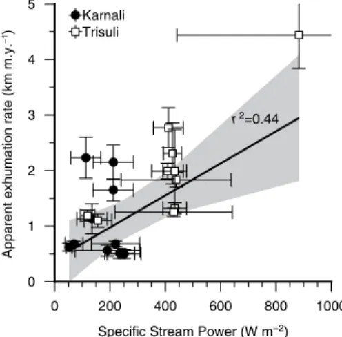
Before comparing the patterns of thermo-chronological ages and specific stream power between western and central Nepal, we need to establish whether these two measures record a similar signal. Because they pertain to exhuma-tion and incision rates on largely different space and time scales, a strong correlation between the two should not be expected a priori (e.g., Vernon et al., 2009; Bermúdez et al., 2013; Abrahami et al., 2016). To test this, we compare inferred local exhumation rates with calculated specific stream power close to the sampling sites (Fig. 3). We find a positive correlation (r2 = 0.44; p =
0.001), suggesting that the two measures are recording the same signal of rock uplift and the erosional response to it, albeit on different time scales. This inference is consistent with the finding that short-term erosion rates in cen-tral Nepal, as recorded by detrital cosmogenic nuclide analysis, mimic the pattern of long-term exhumation rates inferred from thermochronol-ogy data (Godard et al., 2014).
When comparing the data from the two tran sects, the differences between western and central Nepal are conspicuous. AFT ages are sig-nificantly younger and inferred exhumation rates correspondingly higher in the Trisuli transect of central Nepal. This difference is particularly pronounced for the samples collected from the Lesser Himalaya between the (Dadeldhura and Kathmandu) klippen and the Greater Himalaya: AFT ages are 8–6 Ma along the Karnali River, whereas they are only 3–2 Ma along the Trisuli River. Similarly, the specific stream-power trend of the Trisuli River is dominated by a major peak coinciding with the topographic transition zone and the region of youngest AFT ages, whereas the Karnali profile shows a more evenly distrib-uted pattern, with three distinct peaks along the river. Maximum specific stream-power values along the Trisuli River are nearly four times those along the Karnali River.
These differences appear consistent with the different geometries of the MHT in western versus central Nepal as inferred from geo-detic data and topographic patterns (Berger et al., 2004; Harvey et al., 2015). The young thermochronological ages and specific stream-power peak observed along the Trisuli River, at the topographic transition zone between the Lesser and the Greater Himalaya, can both be explained by focused rock uplift and exhuma-tion over a major crustal ramp in the MHT (Lavé and Avouac, 2001; Robert et al., 2009, 2011; Herman et al., 2010). In contrast, the gradually northward younging and generally older AFT ages observed along the Karnali River, combined with the lower values and more diffuse pattern of specific stream power, reflect lower and spa-tially more uniform exhumation and incision rates, consistent with the kinematics imposed by a gently (<10°) dipping detachment without a major ramp (Robert et al., 2011; Coutand et al., 2014). In detail, the peak in specific stream power observed where the Karnali River crosses the southern part of the Dadeldhura klippe could reflect incision in response to recent rock uplift above a newly formed smaller ramp in the MHT in western Nepal, as suggested by Harvey et al. (2015). The current thermochronological data set is insufficient to resolve any long-term exhuma-tional response to movement along this structure. Farther north along the Karnali transect, the young ages in the immediate vicinity of the MCT are not consistent with the kinematics of exhuma-tion above a planar dipping detachment and may suggest the existence of a minor ramp beneath the MCT in western Nepal as well (Harvey et al., 2015). Alternatively, they could record the more complex kinematics of this region, which is affected by an active, west-northwest–striking (i.e., oblique to the orogen) system of right-lat-eral shear zones (Murphy and Copeland, 2005; Murphy et al., 2014; Nagy et al., 2015). This system overprints the MCT zone in the Karnali valley (Mercier, 2014) and may have resulted in localized recent exhumation along this zone. It could also constitute the lateral ramp separating the segments of the MHT with different geom-etries in western and central Nepal.
The strong apparent link between the geom-etry of the crustal-scale detachment underlying the Himalaya and the surface patterns of topogra-phy, exhumation, and incision capacity of rivers, both across and along the orogen, suggests that the primary driver for the lateral variations in these observables is tectonics, with climate play-ing a subordinate role. In the model that emerges, the topography and kinematics of the range are controlled by the geometry of the plate inter-face, lateral variations in which may be due to inherited structures on the underthrusting Indian plate (Gahalaut and Kundu, 2012; Godin and Harris, 2014) or, alternatively, may reflect tran-sient behavior of the accreting Lesser Himalayan
thrust stack, oscillating between frontal accre-tion without a major ramp, and basal accreaccre-tion in the presence of a ramp (Duncan et al., 2003; Mercier, 2014). The topographic steps focus oro-graphic precipitation (Bookhagen and Burbank, 2006, 2010), and thereby the erosional power required to counteract rock uplift above the ramp (where it exists). Our results therefore imply that along-strike climatic variations in the Himalaya respond to tectonically controlled topographic changes, rather than driving them.
ACKNOWLEDGMENTS
This study was supported by the INSU-CNRS Sys-tème Terre program. ISTerre (Institut des Sciences de la Terre) is part of the LabEx OSUG@2020 (ANR10 LABX56; Observatoire des Sciences de l’Univers de Grenoble). We thank Rachel Abrahami for drafting Figure 1, Taylor Schildgen for commenting on an early version of the manuscript, Doug Burbank and Vincent Godard for constructive reviews, and James Spotila for editorial handling.
REFERENCES CITED
Abrahami, R., van der Beek, P., Huyghe, P., Hard-wick, E., and Carcaillet, C., 2016, Decoupling of long-term exhumation and short-term erosion rates in the Sikkim Himalaya: Earth and Planetary Science Letters, v. 433, p. 76–88, doi: 10 .1016 /j .epsl .2015 .10 .039.
Berger, A., Jouanne, F., Hassani, R., and Mugnier, J.L., 2004, Modelling the spatial distribution of pres-ent-day deformation in Nepal: How cylindrical is the Main Himalayan Thrust in Nepal?: Geophysi-cal Journal International, v. 156, p. 94–114, doi: 10 .1111 /j .1365 -246X .2004 .02038 .x.
Bermúdez, M.A., van der Beek, P.A., and Bernet, M., 2013, Strong tectonic and weak climatic control on exhumation rates in the Venezuelan Andes: Lithosphere, v. 5, p. 3–16, doi: 10 .1130 /L212 .1. Bollinger, L., Henry, P., and Avouac, J.P., 2006,
Moun-tain building in the Nepal Himalaya: Thermal
0 1 2 3 4 5
Apparent exhumation rate (km m.y.
−1)
0 200 400 600 800 1000
Specific Stream Power (W m−2)
r2=0.44 Karnali
Trisuli
Figure 3. Comparison between specific stream power and exhumation rate estimated from apatite fission-track (AFT) ages. Specific stream power and its standard deviation cor-respond to that of the three measurements in the river closest to the AFT sampling site. Note that only AFT data sampled directly along the rivers are included in this plot. Continuous black line and gray shading show linear error-weighted correlation and 95% confidence interval, respectively.
and kinematic model: Earth and Planetary Sci-ence Letters, v. 244, p. 58–71, doi: 10 .1016 /j .epsl .2006 .01 .045.
Bookhagen, B., and Burbank, D.W., 2006, Topogra-phy, relief, and TRMM-derived rainfall variations along the Himalaya: Geophysical Research Let-ters, v. 33, L08405, doi: 10 .1029 /2006GL026037. Bookhagen, B., and Burbank, D.W., 2010, Toward a
complete Himalayan hydrological budget: Spa-tiotemporal distribution of snowmelt and rainfall and their impact on river discharge: Journal of Geophysical Research, v. 115, F03019, doi: 10 .1029 /2009JF001426.
Brewer, I.D., and Burbank, D.W., 2006, Thermal and kinematic modeling of bedrock and detrital cooling ages in the central Himalaya: Journal of Geo physical Research, v. 111, B09409, doi: 10 .1029 /2004JB003304.
Burbank, D.W., Blythe, A.E., Putkonen, J.K., Pratt-Sitaula, B.A., Gabet, E.J., Oskin, M.E., Barros, A.P., and Ojha, T.P., 2003, Decoupling of erosion and precipitation in the Himalaya: Nature, v. 426, p. 652–655, doi: 10 .1038 /nature02187. Coutand, I., Whipp, D.M., Grujic, D., Bernet, M.,
Fellin, M.G., Bookhagen, B., Landry, K.R., Ghal-ley, S.K., and Duncan, C., 2014, Geometry and kinematics of the Main Himalayan Thrust and Neogene crustal exhumation in the Bhutanese Himalaya derived from inversion of multither-mochronologic data: Journal of Geophysical Research, v. 119, p. 1446–1481, doi: 10 .1002 /2013JB010891.
Duncan, C., Masek, J., and Fielding, E., 2003, How steep are the Himalaya? Characteristics and im-plications of along-strike topographic variations: Geology, v. 31, p. 75–78, doi: 10 .1130 /0091 -7613 (2003)031 <0075: HSATHC>2 .0 .CO;2. Elliott, J.R., Jolivet, R., González, P.J., Avouac, J.P.,
Hollingsworth, J., Searle, M.P., and Stevens, V.L., 2016, Himalayan megathrust geometry and re-lation to topography revealed by the Gorkha earthquake: Nature Geoscience, v. 9, p. 174–180, doi: 10 .1038 /ngeo2623.
Gahalaut, V.K., and Kundu, B., 2012, Possible influ-ence of subducting ridges on the Himalayan arc and on the ruptures of great and major Himalayan earthquakes: Gondwana Research, v. 21, p. 1080– 1088, doi: 10 .1016 /j .gr .2011 .07 .021.
Godard, V., Bourlès, D.L., Spinabella, F., Burbank, D.W., Bookhagen, B., Fisher, G.B., Moulin, A., and Léanni, L., 2014, Dominance of tectonics over climate in Himalayan denudation: Geology, v. 42, p. 243–246, doi: 10 .1130 /G35342 .1. Godin, L., and Harris, L.B., 2014, Tracking
base-ment cross-strike discontinuities in the Indian crust beneath the Himalayan orogen using grav-ity data—Relationship to upper crustal faults: Geophysical Journal International, v. 198, p. 198– 215, doi: 10 .1093 /gji /ggu131.
Grandin, R., Doin, M.-P., Bollinger, L., Pinel-Puyssé-gur, B., Ducret, G., Jolivet, R., and Sapkota, S.N.,
2012, Long-term growth of the Himalaya inferred from interseismic InSAR measurement: Geol-ogy, v. 40, p. 1059–1062, doi: 10 .1130 /G33154 .1. Grujic, D., Coutand, I., Bookhagen, B., Bonnet, S.,
Blythe, A., and Duncan, C., 2006, Climatic forc-ing of erosion, landscape, and tectonics in the Bhutan Himalayas: Geology, v. 34, p. 801–804, doi: 10 .1130 /G22648 .1.
Harvey, J.E., Burbank, D.W., and Bookhagen, B., 2015, Along-strike changes in Himalayan thrust geom-etry: Topographic and tectonic discontinuities in western Nepal: Lithosphere, v. 7, p. 511–518, doi: 10 .1130 /L444 .1.
Herman, F., et al., 2010, Exhumation, crustal deforma-tion, and thermal structure of the Nepal Himalaya derived from the inversion of thermochronologi-cal and thermobarometric data and modeling of the topography: Journal of Geophysical Research, v. 115, B06407, doi: 10 .1029 /2008JB006126. Jouanne, F., Mugnier, J.L., Gamond, J.F., Le Fort, P.,
Pandey, M.R., Bollinger, L., Flouzat, M., and Avouac, J.P., 2004, Current shortening across the Himalayas of Nepal: Geophysical Journal Inter national, v. 157, p. 1–14, doi: 10 .1111 /j .1365 -246X .2004 .02180 .x.
Lavé, J., and Avouac, J.P., 2001, Fluvial incision and tectonic uplift across the Himalayas of central Nepal: Journal of Geophysical Research, v. 106, p. 26,561–26,591, doi: 10 .1029 /2001JB000359. Le Roux-Mallouf, R., et al., 2015, Evidence for a wide
and gently dipping Main Himalayan Thrust in western Bhutan: Geophysical Research Letters, v. 42, p. 3257–3265, doi: 10 .1002 /2015GL063767. Mercier, J., 2014, Structure et dynamique des prismes
orogéniques: Une approche plurisdisciplinaire sur le cas Himalaya [Ph.D. thesis]: Grenoble, France, Université de Grenoble, 343 p.
Murphy, M.A., and Copeland, P., 2005, Transtensional deformation in the central Himalaya and its role in accommodating growth of the Himalayan orogen: Tectonics, v. 24, TC4012, doi: 10 .1029 /2004TC001659.
Murphy, M.A., Taylor, M.H., Gosse, J., Silver, C.R.P., Whipp, D.M., and Beaumont, C., 2014, Limit of strain partitioning in the Himalaya marked by large earthquakes in western Nepal: Nature Geo-science, v. 7, p. 38–42, doi: 10 .1038 /ngeo2017. Nábelek, J., Hetényi, G., Vergne, J., Sapkota, S., Kafle,
B., Jiang, M., Su, H., Chen, J., and Huang, B.-S., and the Hi-Climb Team, 2009, Underplating in the Himalaya-Tibet collision zone revealed by the Hi-CLIMB experiment: Science, v. 325, p. 1371– 1374, doi: 10 .1126 /science .1167719.
Nagy, C., Godin, L., Antolín, B., Cottle, J., and Ar-chibald, D., 2015, Mid-Miocene initiation of orogen-parallel extension, NW Nepal Hima-laya: Lithosphere, v. 7, p. 483–502, doi: 10 .1130 /L425 .1.
Robert, X., van der Beek, P., Braun, J., Perry, C., Du-bille, M., and Mugnier, J.-L., 2009, Assessing Quaternary reactivation of the Main Central thrust
zone (central Nepal Himalaya): New thermochro-nologic data and numerical modeling: Geology, v. 37, p. 731–734, doi: 10 .1130 /G25736A .1. Robert, X., van der Beek, P., Braun, J., Perry, C., and
Mugnier, J.-L., 2011, Control of detachment ge-ometry on lateral variations in exhumation rates in the Himalaya: Insights from low-temperature thermochronology and numerical modeling: Jour-nal of Geophysical Research, v. 116, B05202, doi: 10 .1029 /2010JB007893.
Sakai, H., Iwano, H., Danhara, T., Hirata, T., and Taki gami, Y., 2013, Emplacement of hot Lesser Himalayan nappes from 15 to 10 Ma in the Jumla-Surkhet region, western Nepal, and their thermal imprint on the underlying early Miocene fluvial Dumri Formation: The Island Arc, v. 22, p. 361– 381, doi: 10 .1111 /iar .12030.
Scherler, D., Bookhagen, B., and Strecker, M.R., 2014, Tectonic control on 10Be-derived erosion
rates in the Garhwal Himalaya, India: Journal of Geophysical Research, v. 119, p. 83–105, doi: 10 .1002 /2013jf002955.
Schulte-Pelkum, V., Monsalve, G., Sheehan, A., Pan-dey, M.R., Sapkota, S., Bilham, R., and Wu, F., 2005, Imaging the Indian subcontinent beneath the Himalaya: Nature, v. 435, p. 1222–1225, doi: 10 .1038 /nature03678.
Thiede, R.C., and Ehlers, T.A., 2013, Large spatial and temporal variations in Himalayan denuda-tion: Earth and Planetary Science Letters, v. 371, p. 278–293, doi: 10 .1016 /j .epsl .2013 .03 .004 (erratum available at http: / /dx .doi .org /10 .1016 /j .epsl .2013 .07 .004).
Vernon, A.J., van der Beek, P.A., and Sinclair, H., 2009, Spatial correlation between long-term exhu-mation rates and present-day forcing parameters in the western European Alps: Geology, v. 37, p. 859–862, doi: 10 .1130 /G25740A .1.
Willett, S.D., and Brandon, M.T., 2013, Some analyti-cal methods for converting thermochronometric age to erosion rate: Geochemistry, Geophysics, Geosystems, v. 14, p. 209–222, doi: 10 .1029 /2012GC004279.
Wobus, C.W., Hodges, K.V., and Whipple, K.X, 2003, Has focused denudation sustained active thrusting at the Himalayan topographic front?: Geology, v. 31, p. 861–864, doi: 10 .1130 /G19730 .1. Yin, A., 2006, Cenozoic tectonic evolution of the
Hi-malayan orogen as constrained by along-strike variation of structural geometry, exhumation his-tory, and foreland sedimentation: Earth-Science Reviews, v. 76, p. 1–131, doi: 10 .1016 /j .earscirev .2005 .05 .004.
Manuscript received 28 November 2015 Revised manuscript received 27 February 2016 Manuscript accepted 29 February 2016 Printed in USA