HAL Id: hal-00305116
https://hal.archives-ouvertes.fr/hal-00305116
Submitted on 17 Dec 2007
HAL is a multi-disciplinary open access
archive for the deposit and dissemination of
sci-entific research documents, whether they are
pub-lished or not. The documents may come from
teaching and research institutions in France or
abroad, or from public or private research centers.
L’archive ouverte pluridisciplinaire HAL, est
destinée au dépôt et à la diffusion de documents
scientifiques de niveau recherche, publiés ou non,
émanant des établissements d’enseignement et de
recherche français ou étrangers, des laboratoires
publics ou privés.
since the 1990s as a consequence of sediment depletion
X. X. Lu, S. R. Zhang, S. P. Xie, P. K. Ma
To cite this version:
X. X. Lu, S. R. Zhang, S. P. Xie, P. K. Ma. Rapid channel incision of the lower Pearl River (China)
since the 1990s as a consequence of sediment depletion. Hydrology and Earth System Sciences
Dis-cussions, European Geosciences Union, 2007, 11 (6), pp.1897-1906. �hal-00305116�
Hydrol. Earth Syst. Sci., 11, 1897–1906, 2007 www.hydrol-earth-syst-sci.net/11/1897/2007/ © Author(s) 2007. This work is licensed under a Creative Commons License.
Hydrology and
Earth System
Sciences
Rapid channel incision of the lower Pearl River (China) since the
1990s as a consequence of sediment depletion
X. X. Lu1, S. R. Zhang1, S. P. Xie2, and P. K. Ma2
1Department of Geography, National University of Singapore, Singapore 119260, Singapore 2Zhaoqing Hydrological Bureau of Guangdong Province, Zhaoqing 526060, Guangdong, China
Received: 27 June 2007 – Published in Hydrol. Earth Syst. Sci. Discuss.: 9 July 2007 Revised: 5 October 2007 – Accepted: 26 November 2007 – Published: 17 December 2007
Abstract. This paper reported a dramatic channel incision
(>10 m in the deepest cut) during the past 10 y or so in the lower Pearl River, the second largest river in terms of wa-ter discharge in China. The channel incision had caused changes both in the channel geometry as well as in the river hydraulics. Also, the water exchange between the two major tributaries of the Pearl River, the Xijiang and Beijiang, had been significantly changed due to the channel incision. The rapid channel incision was principally the result of extensive sand mining in the lower Pearl River and the delta region due to the booming economy in the Pearl Delta region. Slight increase of water discharge and significant decrease of sedi-ment load since the early 1990s in both the Xijiang and Bei-jiang also likely contributed to the observed dramatic river bed downcutting to some extent. This has important implica-tions for river management, as the large Chinese rivers have seen a dramatic depletion of sediment fluxes due to the com-bined effects of declining rainfall, dam constructions, water diversion, reforestation and afforestation, and sediment min-ing over the recent decades.
1 Introduction
Hydro-climatic fluctuations and disturbances of human ac-tivities over the past decades or even centuries resulted in deposition or erosion of alluvial river beds and other forms of river channel changes. Channel incision of a alluvial river as a result of sediment depletion has a series of detrimental effects, such as groundwater table lowering, flood flow in-crease, the destabilization of infrastructures (e.g. bridges, and dykes), sea water encroachment in the coast regions, disrup-tions to in-stream biological communities and several other biological and environmental impacts (Bravard et al., 1997; Rinaldi et al., 2005). It is noticed that human activities can
Correspondence to: X. X. Lu
sometimes induce channel change more significantly than those by natural events such as floods, droughts and land-slides (Petts and Amoros, 1996; Surian and Rinaldi, 2003). For example, effects of sediment mining on alluvial river incision have been huge (Rinaldi et al., 2005). This has been well documented for the rivers in California (Harvey and Shumm, 1987; Collins and Dunne, 1990; Kondolf and Swanson, 1993; Kondolf, 1994; Kondolf, 1997; Sandecki and Avila, 1997), Washington (Collins and Dunne, 1989), Italy (Surian and Rinaldi, 2003; Rinaldi and Simon, 1998; Rinaldi, 2003), Spain (Rovira et al., 2005), France (Peiry, 1987; Petit et al., 1996; Bravard et al., 1999; Gaillot and Pi´egay, 1999; Arnaud-Fassetta, 2003), UK (Sear and Archer, 1998), New Zealand (Page and Heerdegen, 1985) and Aus-tralia (Davis et al., 2000).
The large Chinese rivers have seen a dramatic depletion of sediment load during the past several decades. For exam-ple, the annual sediment discharge in the Yellow River has declined from over 1000 Mt as often cited in the literature (Milliman and Meade, 1983) to around 400 Mt in the 1990s (Xu, 2003) and even below 200 Mt in recent years (Wang et al., 2007). Similarly, the annual sediment flux in the Yangtze River has declined from >400 Mt to <200 Mt since the clo-sure of the first stage of the Three Gorges Dam in 2003 for the Yangtze River (Chen et al., 2006; Yang et al., 2006; Yang et al., 2007). Apart from the declining rainfall in North China (Xu, 2003), the construction of the numerous reservoirs, wa-ter diversion and consumption, reforestation and afforesta-tion, and sediment mining are the primary reasons for such decline. For example, sediment mining has been increas-ingly important in reducing sediment load as a result of the booming Chinese economy over the past three decades or so (Chen et al., 2006). The annual in-channel sediment extrac-tion was 40 Mt in the 1980s and 80 Mt in the 1990s in the lower Yangtze River (Chen et al., 2006). However, the detri-mental effects as a result of such massive removal of sedi-ment on the large Chinese rivers have rarely been reported.
Gaoyao
Makou
Sanshui Lingyangxia Gorge
Fig. 1. Lower Pearl River and its delta area showing the study sites (Gaoyao, Sanshui and Makou), and the stretch of the channel from Gaoyao to Makou. The upper figure is the location map and the lower figure is the satellite image for the selected region.
The Pearl River drains an area of 453 700 km2 and it is the second largest river in China in terms of water discharge (336 billion m3) (PRWRC, 1991). Before 1990, the river channels in the lower Pearl River remained in basic balance between deposition and erosion on the whole (Huang et al., 2003; Li, 2003; Qian, 2004). However, the increasing an-thropogenic disturbances have imposed considerable impacts on the river channel. This paper provided the river channel measurements made since the 1990s in the lower Pearl River (a large alluvial river) to assess its rapid incision and conse-quent impacts on the channel geometry and river hydraulics. Also, possible contributing factors to the channel incision are to be presented and discussed. This is significantly important for channel management in large rivers because the previ-ously documented rivers with channel incision are relatively smaller compared to the Pearl River in this study. For ex-ample, Po River in Italy has a drainage area of 70 091 km2, Nepean River in Australia 21 740 km2 and Rhone River in France 20 300 km2, and the remaining <10 000 km2.
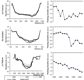
-16 -8 0 8 16 0 200 400 600 8001000 1200 1400 Distance (m) E levat io n (m a. s .l.) 1990 1992 1996 1999 2003 -20 -10 0 10 20 -100 100 300 500 700 900 1100 Distance (m) E levat io n (m a. s .l.) -30 -20 -10 0 10 20 -100 100 300 500 700 900 Distance (m) E levat io n (m a. s .l.) -18 -16 -14 -12 -10 -8 T h al w eg el evat io n (m a. s .l.) -27 -25 -23 -21 -19 -17 -15 T h al w eg el evat io n (m a. s .l.) -12 -10 -8 -6 -4 -2 0 1990 1993 1996 1999 2002 T h al w eg el evat io n (m a. s .l.) (a) G aoyao (b) Sa ns hui (c ) M ak ou
Fig. 2. Cross-section channel profiles and thalweg elevation from 1990 to 2003 determined from the repeated field surveys at stations (a) Gaoyao, (b) Makou and (c) Sanshui. Selective display of the cross-section channel profiles at 5 years: 1990, 1992, 1996, 1999 and 2003 for a better illustration.
2 Study area
The Pearl River, with a drainage area of 453 700 km2 (442 100 km2 is located inside China) is the second largest river in China with an annual water discharge of 336 billion m3(Fig. 1) (PRWRC, 1991). The drainage basin is situated between 21.31◦–26.49◦N and 102.14◦–115.53◦E.
It covers a region of subtropical to tropical monsoon climate straddling the Tropic of Cancer. The mean annual temper-ature across the basin ranges from 14 to 22◦ and the mean
annual precipitation ranges from 1200 to 2200 mm. The Pearl River Basin consists of various source rocks from Pre-cambrian metamorphic rocks to Quaternary fluvial sediments (Zhang et al., 2007b). Carbonates are widely distributed in the basin, accounting for 39% of the total basin area (PRWRC, 1991). The igneous rocks are dominated by gran-ites with acid to intermediate composition, covering about half of the area of Guangdong Province. Small area cover-ages of evaporites and pyrites are mainly scattered in the up-perstream of the Xijiang in Yunnan and Guizhou provinces. Quaternary fluvial sediments are mostly developed in the lower alluvial plain, the delta plain and the interior river val-ley plain of Guangdong and Guangxi provinces. The Pearl River extends from Yunnan Province in Southwest China to Guangdong Province before pouring into South China Sea (SCS) with a total length of 2214 km. The Pearl River system is composed of the three main rivers, Xijiang, Beijiang and Dongjiang, and some small rivers draining the Pearl River
X. X. Lu et al.: Channel incision of the lower Pearl River (China) 1899 Delta (Fig. 1). The runoff and sediment yield are unevenly
distributed in the Pearl River Basin (Zhang et al., 2007b). The contributions of the Xijiang, Beijiang, and Dongjiang to the Pearl River Delta in terms of water discharge are 77%, 15% and 8%, respectively and the contributions of these three rivers in terms of sediment load are 90%, 7%, and 3%, re-spectively. The sediment supply in the Pearl River Delta is mainly coming from the upper Xijiang.
The mainstream of the Xijiang River has distinct names for different sections from upstream to downstream and the section below Wuzhou is called Xijiang. The Xijiang and Beijiang are connected by a small waterway called Shixi-anyao before they flow into the Pearl River Delta through their own courses. The channel from Wuzhou to Makou has a length of 212 m with the average channel slope of 0.09‰ while the channel from Makou to Modaomen waterway (the river mouth) has a length of 139 m with the average slope of 0.048‰. The channel width of the Xijiang at Gaoyao is about 1000 m and the channel depth is about 30 m. The chan-nel width of the Beijiang at Sanshui is about 1100 m and the channel depth is about 25 m. The channel patterns are clearly shown in Fig. 1b. Generally the channels in both the lower Xijiang and Beijiang are straight with alternate sand islands. The sinuosity is about 1.07 for the reach from the Lingyangxia Gorge to the estuary of the Xijiang, and 1.19 for the lower reach of the Beijiang (Xu, 1996). The channel bed composition in the lower Xijiang and Beijiang is mainly sand except in the 8-km long bedrock section of the Lingyangxia Gorge in the low Xijiang.
The riverbed sediment in the lower Xijiang and Beijiang mainly consists of sand, which meets the requirements for construction. For the period with less anthropogenic inter-ruptions (e.g. 1960s), suspended sediment at the Gaoyao sta-tion is made up of sand (grain size 1–0.05 mm), silt (grain size 0.05–0.005 mm) and clay (grain size <0.005 mm) and their composition percentages are 33%, 53%, and 14% re-spectively. Similarly, suspended sediment in the lower Bei-jiang is composed of sand (18%), silt (61%) and clay (21%). Both in the Xijiang and Beijiang, the decreasing trends of grain size of suspended sediment in the downstream direc-tion have been observed which corroborate that the deposited sediment in the riverbed has coarser grain size (Qian, 2004). Based on measurements at Shijiao, during the period 1975– 1977, the medium grain size of bedload in the low Bei-jiang ranges between 0.504 mm and 0.568 mm (Huang et al., 2003). The medium grain size of riverbed material also shows a decreasing trend in the downstream direction in the Beijiang and is about 0.42 mm in the lower Beijiang (San-shui) (Huang et al., 2003).
3 Methods and datasets
Annual channel cross-sections were measured at the three main hydrological stations (Gaoyao and Makou in the lower
0.0 0.1 0.2 0.3 0.4 0.5 0 100000 200000 300000 400000 Drainage area (km2) D o w n cu tt in g rat e (m /yr
) Beijiang River (at Sanshui)
Xijiang River (at Gaoyao)
Po River, Italy Rhône River, France
Xijiang River (at Makou)
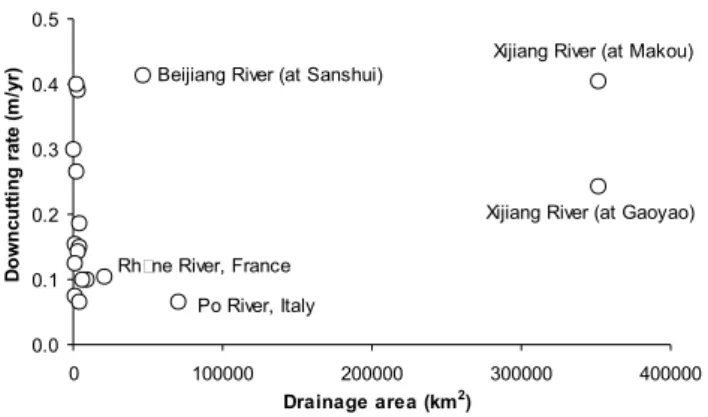
Fig. 3. Comparison of downcutting rates of the documented alluvial rivers suffered from sediment mining. The rivers records are derived from a review of Rinaldi et al. (2005) by adding data in this study.
Xijiang, and Sanshui in the lower Beijiang) (Fig. 1). The equipments used for the measurements were depth sounder before 1999 and Acoustic Doppler Current Profiler (ADCP) after 1999. The measurements were conducted at least once a year in general in the dry season ranging from November to April. The channel geometry changes at the three hydrologi-cal stations were investigated on the basis of the annual mea-surements over the 14 y from 1990 to 2003. In addition to the 3 main cross-sections, there were 25 extra cross-section profiles obtained in the three years of 1992, 1999 and 2003 along the 50 km stretch from Gaoyao to Makou in the lower Xijiang (Fig. 1). The 25 cross-sections were obtained using the navigation charts produced in 1992 and 1999, and the ac-tual ADCP measurements in 2003. The thalweg lines were reconstructed from the 25 cross-sections for the three years to evaluate the longitudinal channel changes.
The influence of river channel incision on river hydraulics was evaluated by comparing the stage-discharge curves from different years. Water levels attained at particular levels of flood water discharge in different years was compared to fur-ther reveal the water level lowering caused by river channel incision. Annual water discharge and suspended sediment flux data were obtained from the gauging station Gaoyao of the Xijiang, and Shijiao of the Beijiang. They were measured following the related Chinese national standard (Ministry of Water Resources of China, 1992).
4 Results
4.1 Channel geometry change at three hydrological stations Based on the cross-section profiles of three stations examined (Gaoyao and Makou in the Xijiang, Sanshui in the Beijiang) during the period of 1990 to 2003 (selective display for repre-sentative years 1990, 1992, 1996, 1999, and 2003 in Fig. 2), significant downcutting in the riverbed has been observed at Gaoyao and Sanshui since 1992, while at Makou since 1994.
Gaoyao 7 9 11 13 15 17 19 C ro ss-sect io n A rea (1 0 3m 2) 1990 1992 1996 1999 2003 Makou 8 12 16 20 C ro ss-sect io n A rea (1 0 3m 2) Sanshui 0 2 4 6 8 10 C ro ss-sect io n A rea (1 0 3m 2) 900 920 940 960 980 1000 Wi d th (m ) 650 750 850 Wi d th (m ) 300 500 700 900 1100 Wi d th (m ) 8 12 16 20 De p th (m ) 12 16 20 24 De p th (m ) 0 2 4 6 8 10 De p th (m ) 50 70 90 110 0 2 4 6 8 10
Water level (m a.s.l.)
W idt h/ D e pt h 30 40 50 60 0 2 4 6 8 10
Water level (m a.s.l.)
W idt h/ D e pt h 30 60 90 120 150 180 0 2 4 6 8 10
Water level (m a.s.l.)
W idt h/ D e pt h (a) (b) (c) (d)
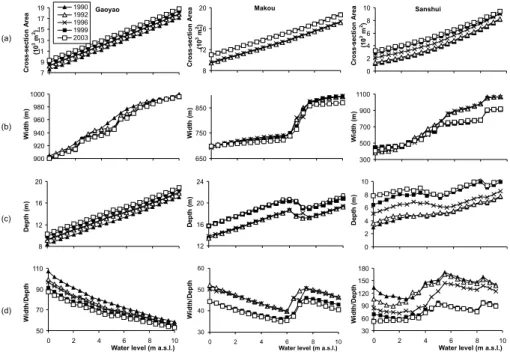
Fig. 4. Channel geometry changes at stations Gaoyao, Makou and Sanshui from 1990 to 2003 (a) cross-section area (b) width (c) depth (d) width/depth ratio. Selective display at 5 years: 1990, 1992, 1996, 1999 and 2003 for a better illustration.
The deepest cut within the 14 y period was 6.3 m at Gaoyao in 1995, 5.8 m at Sanshui in 2003, and 7.1 m at Makou in 1998. The down cuts at the measured sites were much faster and deeper than the documented cases of relative large rivers. For example, Po River in Italy incised 1–6 m along all allu-vial reaches during the period 1880–1990s (Rinaldi et al., 2005), Rhˆone River in south France incised up to 4 m dur-ing 1952-1990 resultdur-ing in considerable channel deependur-ing entrenchment of low flow channel (Petit et al., 1996), and the Rhˆone Delta incised ranging from 1.1 m to 6.8 m during 1907–1991 (Arnaud-Fassetta, 2003) (Fig. 3).
River channel incision has caused a significant change in channel geometry (selective display for years 1990, 1992, 1996, 1999, and 2003 in Fig. 4). Notable increases of the cross-section area have been observed accompanying the down-cuts of river channels at all the three stations exam-ined (Fig. 4a). For example, the cross-section areas when the water level was 0 m increased 22.6% at Gaoyao, 16.4% at Makou, and 170.3% at Shanshui from 1990 to 2003. No obvious changes of channel width were observed at Gaoyao and Makou in the lower Xijiang, while a narrowing of 150 m was recorded at Sanshui since 1998 for higher water levels (>5.0 m) (Fig. 4b). Depth continuously increased from 1990 to 2003 with an average rate of 13 cm/y at Gaoyao, 16 cm/y at Makou, and 26 cm/y at Sanshui (Fig. 4c). The average width/depth ratio of the channel for different water levels de-creased significantly between 1990 and 2003 from 78.2 to 66.9 at Gaoyao, from 46.5 to 40.2 at Makou, and 138.1 to 73.6 at Sanshui (Fig. 4d).
4.2 Channel geometry change along the longitudinal direc-tion in the lower Xijiang
Channel geometric changes have taken place not only at the gauging stations but also along the whole lower Xijiang River. The thalweg line stretching 50 km from Gaoyao down to Makou shows down cuts from 1992 to 2003, though there were occasional depositions (Fig. 5a). Between 1992 and 1999, over 40% of the stretch had down cut over 2 m with the deepest down cut 9.86 m nearby Makou. Between 1999 and 2003, the cross-sections near Gaoyao showed more sig-nificant downcutting with the deepest down cut 14.98 m. Between 1992 and 2003, the rapid channel incision of the stretch between Gaoyao and Makou was observed with down cuts ranging from 1.62 m to 11.29 m. Most of the severely incised cross-sections (>2 m) were located near Gaoyao or near Makou, and the incision showed an upstream trend in recent years. The cross-section areas increased correspond-ing to the downcuttcorrespond-ing of river channels (Fig. 5b).
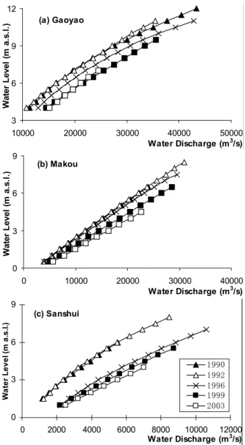
4.3 River hydraulics change: stage-discharge relationship The relations between water level and water discharge were changed at the three sites as a result of the rapid downcut-ting (Fig. 6). Since 1990, water discharge increased at a given water level, with the increased depth and cross-section area of the channel (selective display for years 1990, 1992, 1996, 1999, and 2003 in Fig. 6). For example, when water level was 10 m, water discharge increased by 2900 (9.4%), 3400 (25.0%) and 6500 m3/s (15.0%) in 1999 as compared to
X. X. Lu et al.: Channel incision of the lower Pearl River (China) 1901 -50 -45 -40 -35 -30 -25 -20 -15 -10 -5 0 -5000 0 5000 10000 15000 20000 25000 30000 35000 40000 45000 50000 Distance (m) E levat io n (m a. s .l.) 1992 1999 2003 1 2 3 4 5 6 7 8 9 10 11 12 13 14 1517 1618 19 21 20 22 2324 25 (a) 0 2000 4000 6000 8000 10000 12000 14000 16000 18000 20000 -5000 0 5000 10000 15000 20000 25000 30000 35000 40000 45000 50000 Distance (m) C ro ss-sect io n ar ea (m 2) 1992 1999 2003 1 2 3 4 5 6 7 8 9 10 11 12 13 14 15 17 1618 19 21 20 22 2324 25 (b)
Fig. 5. Thalweg change of longitude profile of the reach be-tween Gaoyao to Makou in 1992, 1999, and 2003 (a) altitude (b) cross-section area (25 cross-sections between Gaoyao and Makou, 1=Gaoyao, 25=Makou). Cross-sections in 1992 and 1999 were ob-tained based on the river channel topographic maps, and the cross-sections in 2003 were surveyed in the field.
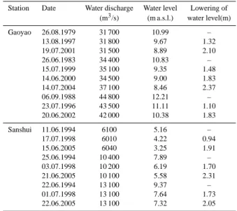
1988, at Gaoyao, Sanshui and Makou respectively. One the other hand, the water level decreased with a given discharge as a result of downcutting. For example, the water level be-tween 1992 and 2002 was lowered by 2.0 m on average at Gaoyao, 1.5 m at Makou, and 3.0 m at Sanshui. At Gaoyao and Sanshui stations, the lowering of flood water level had shown a gradually increasing tendency with the down-cutting of river channel (Table 1). On average, the lowering of flood water level was about 1.5 m in the late 1990s and about 2.0 m in the 2000s when compared with the floods of similar wa-ter discharge pre-1990s or in the early 1990s. The observed lowering of water levels as a result of the downcutting is dra-matic, given the short period and the large drainage area com-pared to the documented rivers, such as the Wisloka River with a drainage area of 4096 km2, where the water level low-ering was only <1.0 m over the period of about 30 years (Wy˙zga,1997; 2001; Lach and Wy˙zga, 2002).
The impact of the rapid incision on the water level had reached further upstream. For example, from Wuzhou down
(a) Gaoyao 3 6 9 12 10000 20000 30000 40000 50000 Water Discharge (m3/s) Wat e r L evel (m a. s. l. ) (b) Makou 0 3 6 9 0 10000 20000 30000 40000 Water Discharge (m3/s) Wat e r L evel (m a. s .l.) (c) Sanshui 0 3 6 9 0 2000 4000 6000 8000 10000 12000 Water Discharge (m3/s) W a te r L e v e l (m a .s .l .) 1 9 9 0 1 9 9 2 1 9 9 6 1 9 9 9 2 0 0 3 Fig. 6
Fig. 6. Changes in the relations between water level and water dis-charge caused by channel incision during the period 1990–2003 at stations (a) Gaoyao, (b) Makou and (c) Sanshui.
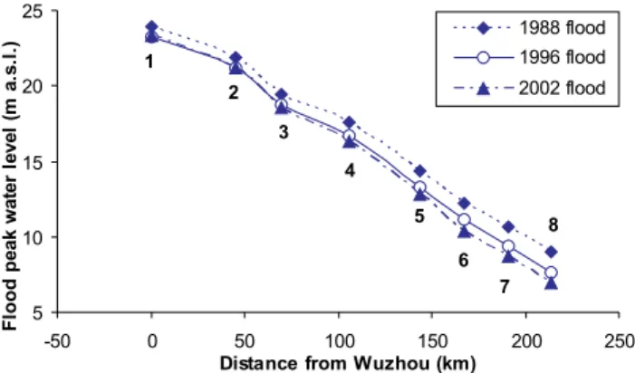
to Makou the flood water levels for a given discharge of 43 000 m3/s declined progressively, with 0.5 m decline at Wuzhou and 2.05 m decline at Makou in 2002 compared to 1988 (Fig. 7). As a result, the flood water surface had in-creased the gradient, potentially causing more damages. For example, from Wuzhou to Makou the flood water surface slope had an increase from 0.063‰ for the 1988 flood to 0.066‰ for the 1996 flood and to 0.070‰ for the 2002 flood. In addition to the increase in the flood damages, the increased water surface slope could increase the sediment transport ca-pacity and accelerate channel incision further, which could in turn modify the morphology of the river channel.
5 10 15 20 25 -50 0 50 100 150 200 250
Distance from Wuzhou (km)
F lo o d p eak w at er level (m a. s .l.) 1988 flood 1996 flood 2002 flood 1 2 3 4 5 6 7 8
Fig. 7. Flood peak water level in 1988, 1996, and 2002 floods at a discharge of 43 000 m3/s along the stretch from Wuzhou to Makou. 1. Wuzhou; 2. Ducheng; 3. Deqing; 4. Liudu; 5. Shunwei; 6. Gaoyao; 7. Guangli; 8. Makou.
4.4 Water exchange between the Xijiang and the Beijiang The channel incision also caused significant change in the water exchange between the Xijiang and the Beijiang through the Shixianyao waterway connection (Fig. 8). The Shixianyao waterway played an important role in regulating the water from the Beijiang to the Xijiang before the occur-rences of the massive channel incision. The channel bed at Sanshui (Beijiang) was around 10 m higher than at Makou (Xijiang), hence the water would flow from the Beijiang to the Xijiang under normal flood condition. Due to the fact that the Beijiang channel at Sanshui was more incised than the Xijiang at Makou after the 1990s, the Shixianyao wa-terway has began to play its opposite role in regulating the water from the Xijiang to the Beijiang. As a result, the an-nual water discharge at Sanshui increased significantly since the 1990s (Fig. 8). The average percentage of the water dis-charge at Sanshui in terms of the sum of the water disdis-charge at Sanshui and Makou increased from 14.4% to 23.1% from 1959–1992 to 1993–2003.
5 Discussions
5.1 Possible causes of channel incision
River channel change, like incision or deposition, is a natu-ral process for an alluvial river. However, increasing human activities such as sand mining, construction of reservoirs and land use alterations have accelerated this geomorphological process (Surian, 1999; Rinaldi, 2003; Li et al., 2007). The causes of such rapid incision require an in-depth analysis on the water discharge and sediment flux changes as a result of various human activities and possible climate variations. This paper provides a preliminary analysis from the aspect of sediment depletion due to sand mining and reduced up-stream sediment supply.
0 20 40 60 80 100 120 1959 1963 1967 1971 1975 1979 1983 1987 1991 1995 1999 2003 Year Wat e r d is ch ar g e (1 0 8m 3) 0 5 10 15 20 25 30 P e rc e n ta g e (% )
water discharge percentage
Fig. 8. Long-term variations of water discharge at Sanshui and the percentage of water discharge at Sanshui in terms of the sum of water discharge at Sanshui and Makou.
5.1.1 In-Channel sand mining
The intensive in-channel sand mining appears to be the prin-cipal factor causing the rapid channel incision in the lower Pearl River. The demand for sand as construction material has been high since the economic reform in the late 1970s across the Pearl River Delta, particularly since the end 1980s. The Pearl River Delta is one of the rapidly industrializing and important agricultural areas in China and the total popu-lation in the Delta region (including Hong Kong and Macau) increased from 12.59 million to 50.0 million with the urban-ization rate of >70%. Some of the cities in the region were literally built from scratch. For example, Dongguan has been built from a tiny fishing village before 1978 to a city with a population of 6.5 million. As a result, sediment mining has been intensive in the large scale, and the rapid channel inci-sion has been very common across the whole delta area. For example, it was reported that the channel was incised over 8 m from 1989 to 2001 in the channel of the river mouth to South China Sea (PRWRC, 2003).
During the period 1984–1999, the averaged annual sedi-ment extracted through mining from the Pearl River Delta (the Xijiang and Beijiang portion) was 46–53×106m3, equivalent to 59.8–68.9 Mt (Peng et al., 2003), which is close to the annual suspended load from the Xijiang and Beijiang. However, the extracted amount is much higher than bed-load (normally 5∼10% of suspended load), which is the principal portion for sand extracting. Moreover, based on the sediment budget of Peng et al. (2003), the annual sediment deposition rate is about 17.7 Mt during the period 1984–1999 by calcu-lating the difference between the sediment supply to the delta region and the sediment export to the open sea. Hence, the sediment extraction rate in the lower Pearl River enormously exceeds the sediment replenishment rate, which is supposed to result in substantial incision and almost irreversible chan-nel adjustments (Rinaldi et al., 2005).
X. X. Lu et al.: Channel incision of the lower Pearl River (China) 1903 5.1.2 Reduced upper sediment supply
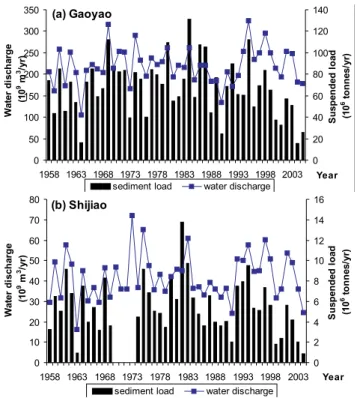
Apart from sediment mining, there may be other causes of river channel incision, such as sediment reduction due to climate change, and land use change in the drainage basin, e.g. reforestation/afforestation, damming and reservoir con-structions. The long-term series of the water discharge and suspended load of the Xijiang (at Gaoyao) and Beijiang (at Shijiao) (Fig. 9) indicate slight increases of water discharge and significant decreases of suspended sediment load since the early 1990s in both rivers (Zhang et al., 2007a). The averaged annual water discharges were 214.9×10⁹m3 for 1958–1990 and 231.7×10⁹m3 for 1991–2004 at Gaoyao, and 40.9×10⁹m3and 43.8×10⁹m3at Shijiao for the above two periods respectively. The averaged annual suspended sediment load was 71.4 Mt and 57.9 Mt at Gaoyao, and 5.8 and 4.8 Mt at Shijiao for the two periods, respectively. The slightly increased water discharge and significantly de-creased suspended sediment load since the early 1990s may contribute to the channel incision to some extent. However, although about 20% reduction of the total suspended load in the Xijiang and Beijiang could be considered as a signif-icant variation, it is not supposed that the decrease of sed-iment supply can cause such a rapid incision observed in this study as inferred from other studies. For example, two distinct phases of incision were observed in the Arno River, central Italy (Rinaldi and Simon, 1998): the minor degrada-tional phase due to the basin development (construction of weirs, reafforestation) and the accelerated degradation phase due to the extensive sand mining. Also, the decrease of sus-pended load may likely be caused by sand extraction (Yang et al., 2004) because the division of suspended load and bed load is not absolutely fixed and mutual exchange with each other may occur during different hydraulic conditions. Hence, the rapid channel incision observed in the lower Pearl River is likely dominantly caused by in-channel sand mining although it is very difficult to quantify the contributions of these two intertwining processes: sand mining and sediment supply reduction due to changes in the basin scale.
5.2 Environmental effects of channel incision 5.2.1 Flood hazard in downstream regions
Although channel incision reduced the flood peak water level and the flooding risk in the incised reach (Table 1), it has in-creased the concentration of flood flow in the channel and reduced the floodplain retention. For example, the flood peak water level (12.68 m a.s.l.) attained at a discharge of 55 000 m3/s in 2005 is slightly higher than the water level (12.21 m a.s.l.) attained at a discharge of 44 500 m3in 1988. The reduction of floodplain retention can caused increased flood hazard in downstream regions. Abnormally high wa-ter level and increased flood hazard in the Pearl River Delta in the 1990s has been reported (Yang et a., 2001; Peng et
Table 1. the lowering of flood water level accompanying the down-cutting of river channel at Gaoyao and Sanshui stations, under sim-ilar level of water discharge.
Station Date Water discharge Water level Lowering of (m3/s) (m a.s.l.) water level(m)
Gaoyao 26.08.1979 31 700 10.99 – 13.08.1997 31 800 9.67 1.32 19.07.2001 31 500 8.89 2.10 26.06.1983 34 400 10.83 – 15.07.1999 35 100 9.35 1.48 14.06.2000 34 500 9.00 1.83 14.07.2004 37 100 8.46 2.37 06.09.1988 44 800 12.21 – 23.07.1996 43 500 11.11 1.10 20.06.2002 42 000 10.38 1.83 Sanshui 11.06.1994 6100 5.16 – 17.07.1998 6010 4.22 0.94 15.06.2005 6040 3.25 1.91 25.06.1994 10 400 7.89 – 03.07.1998 10 200 6.19 1.70 21.06.2005 10 100 5.58 2.31 22.06.1994 13 100 9.37 – 01.07.1998 13 100 7.64 1.73 22.06.2005 13 100 7.32 2.05
al., 2003; Peng et al., 2004). In 1994 and 1998, floods with peak water level less than 50-year return period at Sanshui and Makou stations brought on destructive floods with peak water level up to 200-year return period in the hinterland of the Pearl River Delta.
5.2.2 Drinking water supply
Channel incision lowers the water level and brings difficulty for drinking water supply in the Pearl River Delta. In 1995, the lowest water level for water extraction in the Dongjiang-Shenzhen Diversion Project has decreased to 0.41 m, which is far below the designed lowest water level 1.78 m. The water level lowering caused by channel incision has caused great economic loss due to adopting new facilities for ex-tracting drinking water while abandoning the existing facil-ities. Moreover, due to the lowering of water level, the wa-ter diversion amount cannot meet the designed amount and the drinking water supply in the Pearl River Delta has been warned.
5.2.3 Infrastructure security (levees, bridges)
Channel incision in the lower Pearl River has brought risks to the security of bank protection infrastructures and bridges. Many levees in the Guangdong Province have shown cracks on the surface, and some of them have collapsed due to the impacts of riverbed downcutting. Bridges in the low Pearl River have also been threatened by the in-channel sand min-ing. Shuidong Bridge in the section of Yaogu in the Xinx-ingjiang River, a tributary of the Lower Xijiang River, has collapsed in May 1993 with the piers scoured due to the
(a) Gaoyao 0 50 100 150 200 250 300 350 1958 1963 1968 1973 1978 1983 1988 1993 1998 2003 Year Wat e r d isch ar g e (1 0 9m 3/y r) 0 20 40 60 80 100 120 140 S us pe nde d loa d (1 0 6to n n es/ yr )
sediment load water discharge
(b) Shijiao 0 10 20 30 40 50 60 70 80 1958 1963 1968 1973 1978 1983 1988 1993 1998 2003 Year Wat e r d isch ar g e (1 0 9m 3/y r) 0 2 4 6 8 10 12 14 16 S us pe nde d loa d (1 0 6to n n es/ yr )
sediment load water discharge
Fig. 9. Variations of water discharge and sediment load over the past decades in the Xijiang and Beijiang at stations (a) Gaoyao and (b) Shijiao, respectively.
sand mining. Youjin Bridge in Sanshui has become a high-risk bridge recently with exposed piers due to the channel downcutting near Sanshui. And more recently, 1600-m Ji-ujiang Bridge in the lower Xijiang in Guangdong Province collapsed on 15 June 2007 due to the hit of a sand-laden boat. The in-channel sand mining is blamed to be the most impor-tant cause of bridge collapse by the local authorities. The water depth at the location of Jiujiang Bridge has increased from 20 m in 1985 to 35∼50 m currently due to the intense sand mining.
5.2.4 Seawater intrusion
The rapid channel incision also contributes to the increasing salty water intrusion and subsequent freshwater shortage in the Pearl River Delta region due to the decreased sediment load to the sea as well as increased channel depth. The most extraordinary cases include seawater intrusion happened in March 1999, December 2003 to March 2004, and Decem-ber 2005 to February 2006, which had serious impacts on fresh water supply in the Pearl River Delta region. For exam-ple, the salt water intrusion from December 2005 to Febru-ary 2006, which is the largest salt water intrusion in the last 43 y, caused a huge problem for the fresh water supply over one month for the cities of Macau, Zhuhai, Zhongshan and Fanyu etc. in the Delta region (Fig. 1). The salt content (Cl−)
of the water supply areas was as high as 6415 mg/l (the na-tional standard for drinking water is <250 mg/l). As a re-sult the local authority had to divert extra water from over 10 large reservoirs upstream to increase water discharge and minimize the salt content for water supply to these cities dur-ing the dry period.
5.2.5 Ecological and environmental impacts
Riparian and aquatic habitats would be altered with the wa-ter table lowering and removing bed mawa-terials through in-channel sand mining (Rinaldi et al., 2005). Moreover, the salt water intrusion could lead to the loss of aquatic habi-tats and greatly change the ecological environments in river systems. The slow-down of the delta acceleration rate in the Pearl River Delta (Li et al., 2004) would reduce the wetland area and influence the biodiversity in the estuary. However, few in-depth studies about ecological and environmental im-pacts of channel incision have been conducted so far in the Pearl River.
6 Conclusions
A dramatic channel incision (>10 m in the deepest cut) has occurred since the 1990s in the lower Pearl River. The chan-nel geometry and the river hydraulics have been dramatically changed due to the rapid downcutting. For example, the channel incision had caused lower water levels across the en-tire lower reaches of the river. The water exchange between the two main rivers of the Pearl River, the Xijiang and Bei-jiang, had also been significantly changed due to the differ-ent amplitude of channel incision in two rivers. Such a rapid downcutting of a large alluvial river has never been reported in the literature.
The rapid channel incision was considered to be princi-pally the result of extensive sand mining in the lower Pearl River and the delta region due to the booming economy in the Pearl Delta region. The sediment extraction rate enormously exceeds the sediment replenishment rate in this study. At the same time, there has been about 20% decrease of suspended load coinciding with channel incision. It is very difficult to quantify the contributions of sand mining and suspended sediment decrease on riverbed downcutting. However, the impact of sand mining is considered to overwhelm that of reduced upperstream sediment supply based on the rapid in-cision observed. An in-depth study is required to pin-point the exact reasons behind such rapid incision, and to develop quantitative relations between the incision and sediment de-pletion.
These channel changes have resulted in various environ-mental and social-economic consequences such as increasing flood hazards in the Pearl River Delta, shortage of drinking water supply, security problem of infrastructures (e.g. lev-ees, bridges), salty water intrusion as well as the alteration of
X. X. Lu et al.: Channel incision of the lower Pearl River (China) 1905 aquatic and riparian ecosystems. Although the Chinese
gov-ernment has enhanced the management of in-channel sand mining in the lower Pearl River since the end of the 1990s, the illegal mining activities are still rampant. Tighter restric-tions on in-channel sand mining should be proposed in or-der to reduce or recover the channel incision as well as its detrimental effects in the lower Pearl River. The observed dramatic river bed downcutting as a result of sediment de-pletion has important implications for river management, as the large Chinese rivers have seen a dramatic depletion of sediment fluxes due to the combined effects of declining rain-fall, dam constructions, water diversion, reforestation and af-forestation, and sediment mining over the recent decades. A better understanding of human impacts on river channels is of great importance for river engineering and environmental management.
Acknowledgements. This research was funded by the National
University of Singapore (Grant Number R-109-000-054-112). The authors would like to thank N. Surian and another anonymous referee for their constructive comments.
Edited by: M. Mikos
References
Arnaud-Fassetta, G.: River channel changes in the Rhone Delta (France) since the end of the Little Ice Age: geomorphological adjustment to hydroclimatic change and natural resource man-agement, Catena, 51, 141–172, 2003.
Bravard, J. P., Amoros, C., Pautou, G., et al.: River incision in South-east France: morphological phenomena and ecological ef-fects, Regul. River., 13, 75–90, 1997.
Bravard, J. P., Kondolf, G. M., and Pi´egay, H.: in Incised River Channels: Processes, Forms, Engineering and Management, edited by Darby, S. E., and Simon, A., 303–341, Wiley, Chich-ester, 1999.
Chen, X. Q., Zhou Q. J., and Zhang E. F.: In-channel sand extrac-tion from the mid-lower Yangtze channels and its management: problems and challenges, J. Environmental Planning and Man-agement, 49, 309–320, 2006.
Collins, B. and Dunne, T.: Fluvial geomorphology and river-gravel mining: a guide for planners, case studies included, Special Pub-lication 98, California Department of Conservation, Division of Mines and Geology, 1990.
Collins, B. and Dunne, T.: Gravel transport, gravel harvesting and channel-bar degradation in rivers draining the Southern Olympic Mountains, Washington, USA, Environ. Geol. Water S., 13, 213– 224, 1989.
Davis, J., Bird, J., Finlayson, B., and Scott, R.: The management of gravel extraction in alluvial rivers: a case study from the Avon River, southeastern Australia, Phys. Geogr., 21, 133–154, 2000. Gaillot, S. and Pi´egay, H.: Impact of gravel mining on stream
chan-nel and coastal sediment supply: example of the Calvi Bay in Corsica (France), J. Coastal Res., 15, 774–788, 1999.
Harvey, M. D. and Shumm, S. A.: in Erosion and Sedimentation in the Pacific Rim, edited by: Beschta, R. L., Blinn, T., Grant, G.
E., Beschta, R. L., et al., 451–460, International Association of Hydrological Sciences, Wallingford, 1987.
Huang, B., Lian, W., Du, J., and Zhang, G.: The study on dyke renovation in the Datang-Suijiangkou section of Beijiang dyke, Guangdong Water Resources and Hydropower, 2, 19–22, 2003 (in Chinese).
Kondolf, G. M. and Swanson, M. L.: Channel adjustments to reser-voir construction and instream gravel mining, Stony Creek, Cal-ifornia, Environ. Geol. Water S., 21, 256–269, 1993.
Kondolf, G. M.: Environmental Management - Hungry water: Ef-fects of dams and gravel mining on river channels, Environ. Man-age., 21, 533–551, 1997.
Kondolf, G. M.: Environmental planning in the regulation and man-agement of instream gravel mining in California, Landscape Ur-ban Plan., 29, 185–199, 1994.
Lach, J. and Wy˙zga, B.: Channel incision and flow increase of the upper Wisloka River, south Poland, subsequent to the reafforesta-tion of its catchment, Earth Surf. Proc. Land., 27, 445–462, 2002. Li, L. Q., Lu, X. X., and Chen, Z.: River channel change during the last 50 years in the middle Yangtze River: an example of the Jianli reach, Geomorphology, 85, 185–196, 2007.
Li, T.: The impact analysis of hydrological characteristics in the Pearl River Delta, Guangdong Hydrology and Water Environ-ment 2, 2003 (in Chinese) (http://www.gdsw.gov.cn/web/law/). Milliman, J. D. and Meade, R. H.: World-wide delivery of river
sediment to the oceans, J. Geol., 91, 1–21, 1983.
Ministry of Water Resources of China: Code for River Suspended Sediment Measurement (GB 50159-92), China Planning Press, Beijing, 1992.
Page, K. J., and Heerdegen, R. G.: Channel change on the lower Manawatu River, New Zealand Geographer, 41, 35–38, 1985. Pearl River Water Resources Committee (PRWRC): Sediment
Re-port. http://www.pearlwater.gov.cn/index.jsp, 2003 (in Chinese). Pearl River Water Resources Committee (PRWRC): The Zhujiang Archive, Vol. 1, Guangdong Science and Technology Press, Guangzhou, 1991 (in Chinese).
Peiry, J. L.: Channel degradation in the middle Arve river, France, Regul. River., 1, 183–188, 1987.
Peng, J., He, S., Liao, W., and Zhang, S.: Large scale system sim-ulation for flood and anti-flood counter measures in Pearl River delta, J. Hydraul. Eng.-ASCE (SHUILI XUEBAO), 11, 78–85, 2003 (in Chinese).
Peng, J., Liao, W., and Yu, X.: Abnormal change of flood water level in hinterland of Pearl River Delta and its cause analysis, J. Natural Disasters, 13(1), 50–54, 2004 (in Chinese).
Petit, F. Poinsart, D., and Bravard, J. P.: Channel incision, gravel mining and bedload transport in the Rhone river upstream of Lyon, France, Catena, 26, 209–226, 1996.
Petts, G. E. and Amoros C.: Fluvial Hydrosystems, Chapman and Hall, London, 1996.
Qian, Y.: The impacts and management measures of in-channel sand mining in the Pearl River Delta, Pearl River, 2, 44–46, 2004 (in Chinese).
Rinaldi, M., and Simon, A.: Bed-level adjustments in the Arno River, Central Italy, Geomorphology, 22, 57–71, 1998.
Rinaldi, M., Wyzga, B., and Surian, N.: Sediment mining in alluvial channels: physical effects and management perspectives, River Res. Appl., 21, 805–828, 2005.
Rinaldi, M.: Recent channel adjustments in alluvial rivers of
cany, Central Italy, Earth Surf. Proc. Land., 28, 587–608, 2003. Rovira, A., Batalla, R. J., and Sala, M.: Response of a river
sed-iment budget after historical gravel mining (The lower Tordera, NE Spain), River Res. Appl., 21, 829–847, 2005.
Sandecki, M. and Avila, C.C.: in Storm-Induced Geologic Hazards: Case Histories from the 1992-1993 Winter in Southern California and Arizona, edited by Larson, R. A. and Slosson, J.E., 39–48, Geological Society of America, Boulder, CO, USA, 1997. Sear, D. and Archer, A. D.: in Gravel-Bed Rivers in the
Environ-ment, edited by Klingeman, P. C., Beschta, R. L., Komar, P. D., and Bradley, J. B., 415–432, Water Resources Publications, LLC: Highlands Ranch, CO. USA, 1998.
Surian, N. and Rinaldi, M.: Morphological response to river engi-neering and management in alluvial channels in Italy, Geomor-phology, 50, 307–326, 2003.
Surian, N.: Channel changes due to river regulation: the case of the Piave River, Italy, Earth Surf. Proc. Land., 24, 1135–1151, 1999. Wang, H. J., Yang, Z. S., Saito, Y., Liu, J. P., Sun, X. X., and Wang, Y.: Stepwise decrease of the Hunaghe (Yellow River) sediment load (1950–2005): Impacts of climate change and human activi-ties, Global Planet. Change, 57, 331–354, 2007.
Wy˙zga, B. A.: Geomorphologist’s criticism of the engineering ap-proach to channelization of gravel-bed rivers: case study of the Raba River, Polish Carpathians, Environ. Manage., 28, 341–358, 2001.
Wy˙zga, B. A.: Methods for studying the response of flood flows to channel change, J. Hydrol., 198, 271–288, 1997.
Xu, J. X.: Fluvial processes in various natural zones of China, Sci-ence Press, Beijing, 260–261, 1996 (in Chinese).
Xu, J. X.: Sediment flux to the sea as influenced by Changing hu-man activities and precipitation: example of the Yellow River, China, Environ. Manage., 31, 328–341, 2003.
Yang, S. L., Zhang, J., Dai, S. B., Li, M., and Xu, X. Y.: Effect of deposition and erosion within the main river channel and large lakes on sediment delivery to the estuary of the Yangtze River, J. Geophys. Res., 112, F02005, doi:10.1029/2006JF000484, 2007. Yang, S. L., Shi, Z., Zhao, H. Y., Li, P., Dai,S. B., and Gao A.: Effects of human activities on the Yangtze River suspended sedi-ment flux into the estuary in the last century, Hydrol. Earth Syst. Sci., 8(6), 1210–1216, 2004.
Yang, Z., Wang, H., Saito, Y., Milliman, J. D., Xu, K., Qiao, S., and Shi, G.: Dam impacts on the Changjiang (Yangtze River) sediment discharge to the sea: the past 55 years and af-ter the Three Gorges Dam, Waaf-ter Resour. Res., 42, W04407, doi:10.1029/2005WR003970, 2006.
Zhang, S. R., Lu, X. X. Higgitt, D. L., Chen, C. T. A., Han, J, T. and Sun, H. G.: Recent changes of water discharge and sediment load in the Zhujiang (Pearl River) Basin, China, Global Planet. Change, doi:10.1016/j.gloplacha.2007.04.003, 2007a (in press). Zhang, S. R., Lu, X. X., Higgitt, D. L., Chen, C. T. A., Sun,
H. G., and Han, J. T.: Water chemistry of the Zhujiang (Pearl River): Natural processes and anthropogenic influences, J Geo-phys. Res., 112, F01011, doi:10.1029/2006JF000493, 2007b. Zhou, Z., Luo, X., Luo, Z., and Yang, Q.: The analysis on the
major reason about local exceptional rise of flood water level in the Pearl River Delta in recent years, Tropical Geography, 21(4), 319–322, 2001(in Chinese).