Crustal structure of the Mid-Atlantic Ridge south of the Kane Fracture Zone from seafloor and sea surface gravity data
Texte intégral
Figure
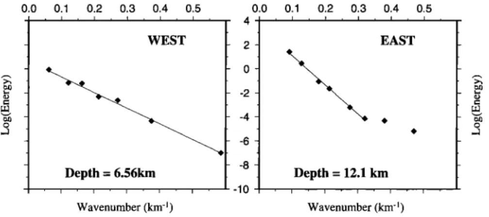
![Figure 3. Density estimation from Nettleton [ 1976] method on an east-west sea bottom profile (located in Figure 2)](https://thumb-eu.123doks.com/thumbv2/123doknet/14792668.602104/7.907.137.770.661.1052/figure-density-estimation-nettleton-method-profile-located-figure.webp)

Documents relatifs
Low-T hydrothermal activ- ity, associated with metal-poor fluids (e.g., Clamstone and Ghost City sites), is likely associated with zones of active serpentinization at depth, with
In Section 2 we define quotient data and describe the Hopf algebra quotients of the smash coproduct of a group algebra by the algebra of functions on a finite group in terms of
Myocardium segmentation without (up) and with (down) inhibitor agents : on the left, one original slice extracted from the whole volume to segment (with the seed points) and on
We conclude that vortex formation and evolution is controlled by three main processes: (1) long-wave radiative cooling, which increases in efficiency with both increasing trace
The diffusive wiggler described above is a simple, passive system in which the pulsed solenoid provides both the guiding axial magnetic field and the transverse
Therefore, modules learning with distributed GAPS using an agreement algorithm with synchronous pairwise disjoint updates to come to a consensus on both the value of the reward, and
Dijkstra algorithm. Just before entering the protocol, each node is assumed to keep only its own identity, the weights of the outgoing adjacent links and the
For the parameter study, both the control voltage and the passive loss factor were varied. The symbol lp will be used to denote the passive loss factor to
