Publisher’s version / Version de l'éditeur:
Vous avez des questions? Nous pouvons vous aider. Pour communiquer directement avec un auteur, consultez la première page de la revue dans laquelle son article a été publié afin de trouver ses coordonnées. Si vous n’arrivez pas à les repérer, communiquez avec nous à [email protected].
Questions? Contact the NRC Publications Archive team at
[email protected]. If you wish to email the authors directly, please see the first page of the publication for their contact information.
https://publications-cnrc.canada.ca/fra/droits
L’accès à ce site Web et l’utilisation de son contenu sont assujettis aux conditions présentées dans le site
LISEZ CES CONDITIONS ATTENTIVEMENT AVANT D’UTILISER CE SITE WEB.
Technical Report (National Research Council of Canada. Division of Building
Research), 1953-03-01
READ THESE TERMS AND CONDITIONS CAREFULLY BEFORE USING THIS WEBSITE. https://nrc-publications.canada.ca/eng/copyright
NRC Publications Archive Record / Notice des Archives des publications du CNRC :
https://nrc-publications.canada.ca/eng/view/object/?id=e857d86d-553c-47a9-a1ea-ad279ef99aa5
https://publications-cnrc.canada.ca/fra/voir/objet/?id=e857d86d-553c-47a9-a1ea-ad279ef99aa5
NRC Publications Archive
Archives des publications du CNRC
For the publisher’s version, please access the DOI link below./ Pour consulter la version de l’éditeur, utilisez le lien DOI ci-dessous.
https://doi.org/10.4224/20386406
Access and use of this website and the material on it are subject to the Terms and Conditions set forth at
Damage to houses, Red River Valley flood, 1950
Ser
TEl
N2i.t2l
n o . 9
e . 2
BI,DG
N A T I O N A L
R E S E A R C H
C O U N C I L
C A N A D AI)amage to Houses
Red River Valley Flood 1950
by
D. H. RUTHERFORD and A. BARACOS
A N A L Y Z E D
March, 1953
TECHNICAL REPORT No. 9
of lhe
DIVISION OF BUILDING RFSEARCH
OTTAWA
NRC No. 2976 DBR No. 23 price 50 cents
PREFACE
. -Thi9 rgport is a factual compilation of the manner in which r,esidential ,b-uildings and building materials performed during the disastrous winnipeg flood of 1950. For convenience a brief
s"tate-The report has been prepared and is now published not only as a matter of public information but in ordef to record in con-venient form essential .information regarding flood-damaged houses in case such information should evei be nieded elsewh"ere in the future.
- . The delay in the publication of this report has been due to the desire to include the statistical tables whiih form such a valuable Appendix- These could only be prepared when the inspection forms were available and this was possible only when all-questions of d.amgse claims had been cleared up. Through the co-operation of the Departments of the Provincial Governm6nt and the Chairman and members of the._Red River Valley Board all the inspection forms were made available to the Division. The staff of the'prairie Regional Office of Central Mortgage and Housing Corporation
Drovided much assistance with the abstraction of the necessary information from the forms and supervised its transfer to punched cards. These were then sent to Otiawa for processing in the Head Office of the Corporation.
residential construction in Canada.
March, 1953.
R. F. Loccnr,
TABLE OF CONTENTS
Introduction The Red River.
The Weather and Previous Red River Floods. . . . . The Flood of 1950.
Field Studies of House Damage
House Damage in the Red River Valley Excluding Winnipeg Extent of Damage in Greater Winnipeg.
House Damage in Greater Winnipeg. Erosion
Structural Damage
Soil and Foundation Conditions. Basement Walls and Footings. Basement Floors
Post and Column Footings Basement Partition Walls. Partial Basements.
Surface and Shallow Foundations House Exteriors. House Interiors Floors W a l l s . . . . Interior Trim. . .. . Doors. Windows. Insulation
Other Materials and Constructions. Electric Services Heating Systems Acknowledgments. . . A p p e n d i x A - S t a t i s t i c a l T a b l e s . . . ,
-T 9
20
20
PecB
4
4
6
I9
1 1
1 3
t 6
t 7
I 7
1 8
1 8
1 9
20
2 5
2 6
2 6
2 7
2 8
28
28
29
2 9
2 9
30
3 2
33
DAMAGE TO HOUSES
RED RIVER VALLEY FLOOD 1950
by
D. H. RuTUERFoRD AND A. Banecos
The most disastrous flood waters in Canadian history swept through the Red River Valley in the spring of 1950 inundating over seven hundred square miles in the Canadian section of the Valley. The Red River, during a normal summer season, has a flow of about five thousand cubic feet per second. During the flood period, however, as much as one hundred thousand cubic feet per second flowed in the channel. This unprecedented flow, resulting from a well-defined series of meteorological events, inundated some of the best farm lands in Western Canada, damaged in varying degree over one hundred thousand homes, and disrupted the daily living of nearly half a million people.
The Red River
The Red River rises in Minnesota and follows a general course nearly true north, until it empties into Lake Winnipeg in Manitoba. At no point along the route does the River leave this straight course by more than six miles. It is a river of the low-velocity meandering-type with its channel length approximately twice its valley length. A number of tributaries enter the Red River, the chief of these being the Assiniboine River at Winnipeg and the Pembina,.Red Lake, Ottertail, and Sheyenne Rivers, south of the International Border. The drainage system thus formed covers one hundred and ten thousand square miles (Fig. 1).
The Red River forms the north-south axis of the lowest of the three steppes which make up the prairie region of Canada. This area, known as the Red River Valley, is roughly fifty miles wide at the Canada-U.S.A. border and from this point extends approximately eighty miles north. A continuation of the steppe extends southward some two hundred miles into the United States. It is a plain made up of glacial drift and lacustrine deposits and was formerly the site of Lake Agassiz, which existed at the close of the last glacial period.
The River provided the first access to the fertile farm lands through which it flows and for many years was the only trans-portalion route available. Consequently early settlers built their homes and places of business along the River banks. This trend has continued to the present day even after other means of trans-portation have become available, with the result that several small towns are located very close to the River. Metropolitan Winnipeg, a city of more than 300,000 people, embraces the junction
S A S K .
M A N .
B N A T I O N A L B O U N 2 A R Y
u . s . A
Fig. I
DRAINAGE SYSTEM OF THE RED RiVE,R
V I N N I P E G
V I N N I P E G
I
I orur.
I
i
I
L=
.13le<a
"*oo
"ff! e.
U P P E R B E ' L A K E L O V E R RE' LAKE .tl I ) ( t l - < ) t n\ z
( z
/ t n\
\ P
o t G ) 2 S C A L E : M I L E 9of the Red and Assiniboine Rivers. Present-day highways and railway lines, in order to accommodate the towns along their routes, follow closely the course of the River. Transportation becomes critical when waters rise sufficiently to cut the lines, thereby isolating entire communities from easy escape or outside aid.
Topographically the area through which the Red River flows can be described simply as "flat". The slope of the valley along the River channel is uniform but averages less than one foot per mile. From the International Border north, the slope averages seven inches to the mile. As a result of this shallow sradient the velocity of flow in the River is low and none of the tri6utaries, nor the Red River itself, have cut deep channels, the deepest cuts being less than sixty feet below prairie grade. In an east and west direction away from the River the slope is sornewhat greater, averaging two to three feet to the mile for the first ten to fifteen miles. Thus it is evident that should an excess of water accumulate in the River drainage system, the escape of the water in the River channel will be slow and any rise in water level, after the River overflows its banks, will result in the inundation of large areas of land adjacent to the River.
The Weather and Previous Red River Floods
Floods have occurred periodically since settlement began in the Red River Valley. A study of existing records reveals that in each case a definite pattern of weather conditions preceded the flood. These were summed up in an address delivered by W. D. Hurst, Winnipeg City Engineer, before the Winnipeg Branih of the Engineering Institute of Canada in March 7949, as follows:
"The conditions giving rise to a flood in the Valley are quite definite and are as follows:
"A cold winter, starting early with a little snow at first, so that the ice on rivers and lakes will be abnormally thick, followed by a heavy snowfall throughout the country with continued cold weather. Then a late, cold spring, so that little snow escapes into the rivers. Then in May, and not usually before, a sudden change of wind to the south so that the whole mass of snow melts at once, precipitating its volume of water into every stream. If such a combination of events comes after a few wet years, when stream and slough are filled with water and the qround itself is saturated then a real catastrophe is imminent."
Mr. Hurst's summary dealt only with that period leading up to the flood. Any precipitation, especially rain, coming at or near the height of the flood on a drainage area not capable of absorbing any of it causes further serious rises in river levels.
The earliest record of flooding along the Red River is that for the year 1826 when Winnipeg was a comparatively new settlement consisting of a few dwellings and a trading post, Upper Fort Garry.
In that year the River reached the highest levels ever known, surpassing by six to seven feet the height reached in 1950.
From the year 1826 until the present time other floods of varying degree have occurred. Between 1882 and 1897 the River overflowed its banks four times but between 1916 and 1948 no serious flooding took place. Of all recorded floods the one of 1950 created the greatest amount of damage and was surpassed in depth of water only by the floods of 1826,1852, and i861.
The Flood of 1950
A "post-mortem" of weather conditions in the Red River Valley from October 1949 until May 1950, made by C. C. Boughner, Head of the Climatological Section of the Department of Transport's Meteorological Division, revealed that a series of meteorological events such as had occurred prior to former serious floods preceded the 1950 flood. October 1949 was the wettest October recorded at Winnipeg, with 5.04 inches of rain and 6.35 inches of snow. The Red River froze on November 22 atWinnipeg; the greater part of December was very cold. January 1950 was one of the coldest months on record throughout the whole River basin. February temperatures were about normal but no, or very little, thawing occurred. Temperatures during March 1950 fluctuated but averaged below normal. In one 24-hour period at Fargo, North Dakota, there was more precipitation than occurs in an entire average March (1.16 inches on March 26 and 27). April1950 at Fargo was the coldest April since 1907. At Winnipeg, temperatures were above normal on only four days; also, precipitation in the form of snow at Winnipeg was the highest recorded for April. Over the entire period October to May precipitation in the Manitoba portion of the River basin was 17.42 inches which is verv nearlv twice the normal of 9.2 inches.
First flooding occurred in the upper reaches of the River. As early as the first week in April, before the ice had gone out of the River at Winnipeg, flooding was reported in North Dakota. First flooding in Manitoba took place at the town of Emerson on the International Boundary on April 20 and from that day until the waters began receding at Winnipeg one month later, a total of 710 square miles of land were progressively inundated. At one time during this period a lake was in existence along the sixty miles of river from Emerson to the southern limits of Winnipeg. In places this lake was more than twenty miles wide.
In Winnipeg itself flooding occurs when the gauge at the James Street pumping station shows a reading of 18.0 feet above City Datum. (Zero City Datum equals geodetic Elevation 727.57 teet.) In 1950, the River rose to give such a reading on April 21, continued to rise until a peak of 30.3 feet above datum was reached on May 19 and fell below the 18.0-foot mark onlv on Tune 10. Thus for fifty days some parts of Winnipeg were flooded.- Levels of the Red River from April 5 to June 10 are shown in Fig. 2.
- N N b O U r O L n c ) u O t o P 1 5 2 i
-.i--.
I
I
t
::: ^,:r:y:
*!.:',?: ?
""
: :::2
!- oRaANIzATloNt sET uP To EATTLE floo0,tP/KING 82
=ll
+- rLooDtNG BErtEvEr-rilMrNENr, MACHTNE4y ttr aP To Et/AcuArE f- orr,*,"o,ru ,rnrXo"r"o. I ANz ctor*t
\ l
=\i
t- r/atr FtoootNa /N sr.v/rAL E) sE/Nc R/r/tq.gac.< ,^y-::?:"yll_
o" I i"T- ,ouot AilD y'oLuNrEER pERsoNNEL -
l3 ,o*t*.,un o,Ktt I
F,^'"'",e4a,EAK,Nstrv,rAt.
iF
\t
l;
5 t o > t s r 5 L c z l O rn 20Field Studies of House Damage
When it became evident that the flood was developing into a major disaster, local authorities began to organize the emergency and relief measures which were soon to attract world-wide attention. National agencies, notably the Canadian Red Cross, came to the assistance of the flooded areas. Eventually conditions became so serious that Brigadier R.E.A. Morton was appointed to supervise provincial flood fighting and relief. Supervision by the Army con-tinued for 25 days, by which time the flood waters had receded five feet. The whole storv of the flood cannot be told in this Report. It must suffice to state here that although one-sixth of the great City was at one time under water, and more than 100,000 people were evacuated to other areas. onlv one life was lost as a direct result of the flood. No epidemic of disease was caused by it and, under the leadership of Winnipeg City Engineer, W. D. Hurst, and other municipal officials in the cities and municipalities comprising Greater Winnipeg, all essential civic services (including water supply and sewerage) were maintained, generally without interruption.
It was damage to individual homes that caused the most distress, resulted in the greatest monetary loss, and attracted the most attention. Many of the newly built houses with which Central Mortgage and Housing Corporation were associated (either directly or because of financial arrangements) were among those most seriously affected. As the flood approached its peak, the Division of Building Research was closely in touch with officers of the Corporation (which it serves in a research capacity) regarding the rehabilitation work which could then be seen to be a coming neces-sity. Inquiries were initiated through all appropriate channels to ascertain if there was available any published or recorded informa-tion, derived from experience with floods elsewhere, which would be of assistance in this impending major task. Though inquiries were directed to authorities connected with all urban areas in North America in which bad flooding had occurred, very little information of value could be found. Some reports of the U.S. Corps of Engineers proved to be the only documents containing helpful information.
Visits to the flooded area by the President of the Corporation, D. B. Mansur, and by the Director of the Division, R. F. Legget, confirmed the impression of local officials that, in addition to the immense physical task of house rehabilitation, some effort should be made to study and record the effect of the flood upon the large number of houses which the River water reached, and in particular, the effect of the flood upon local foundation conditions. Accordingly, two members of the Division's staff (the authors of this Report) were diverted from other housing research work and assigned to the Winnipeg flood study. The authors each spent about three months on this investigation. Observations of foundation conditions are still continuing.
This field study was welcomed most cordially by J. B. Carswell and D. Bruce Shaw, the Commissioners appointed by the Dominion
and Provincial Governments respectively, to assess the extent of the
damage caused by the flood. The Director of the Division was privileged to assist the Commissioners in this work by making a rapid survey of the entire flooded area in the Red River Valley iu order to compare the physical damage in the Valley with that in Greater Winnipeg. This two-day "voyage" through the Valley was made with the late Dr. H. B. Sommerfeld, and officers of a special detachment of the Royal Canadian Mounted Police (established under Inspector K. Lockwood) which did such splendid work in patrolling the vast lake formed by the flood and in assisting the residents who still remained in their flooded homes. This Report includes, with permission, information from the report made by Mr. Legget to the Commissioners immediately following his inspec-tion of the Valley.
When the Red River Valley Board, consisting of C. E. Joslyn, Chairman, Dean J. W. Grant MacEwan, and W.R. Forrester, was set up by the Manitoba Government, the field study of housing reported here was welcomed by the members of the Board. Actual investigations in the field were facilitated by association with the Board, some of the early visits of the authors being made in the company of inspectors appointed by the Board. Working closely with the Prairie Regional Office of C.M.H.C. the Division was able to make a small contribution to the arrangements for the recording of the damage which the flood caused to houses in the Greater Winnipeg area. This work was carried out by an appraisal staff employed by the Board for this purpose under Mr. Blake McCutcheon.
When it was seen that excellent records were being obtained of the damage to houses, it was decided, by mutual consent of all the agencies involved, that a statistical summary of the damage should be prepared from these5ecords as soon as convenient. Studies made by'the Division of Bullding Research had shown the lack of any such statistics in connection with flood damage to houses. When the
records became available, Central Mortgage and Housing
Corporation kindly arranged for the abstracting of essential material from them and the recording of this on punched cards. These cards were then sent to Ottawa where the information which they con-tained was analysed by the statistical staff of the Head Office of the Corporation. The tables resulting from this extensive study are included with this report as Appendix A by kind permission of the Board. It is believed that this is the first time that any such statis-tics, on so comprehensive a scale, have been published and it is believed that they add greatly to the value of the Report.
House Damage in the Red River Valley Excluding Winnipe$ Figure 3 shows the vast area of the Red River Valley which was inundated by flood waters. At the height of the flood, 710 square miles of valuable farm land were under water. As the map indicates, the town of Morris was surrounded by a large lake, with all buildings flooded. Most of the town of Emerson was submerged. Many houses in the smaller settlements were inundated but, because of their location and elevation, it was the towns of Emerson and Morris which suffered the greatest damage. The following table* shows the number of premises in the Valley, exclusive of Greater Winnipeg, inspected for flood damage up to January 31,
1 9 5 1 . Locat'ion Town of Morris M u n i c i p a l i t y o f M o r r i s M u n i c i p a l i t y o f E m e r s o n . M u n i c i o a l i t v o f R i t c h o t . Municiialitv of Rhineland. . .. lvlunrcrDalrtv oI -tv.l ontcalm Municibalitv of MacDonald. . Municioalitv of Franklin. Municipality of De Salaberry Municipality of St. Andrews.. . . . . M u n i c i p a l i t y o f T a c h e . . . . . Municioalitv of St. Clements. 2 3 7 |
In addition to the reconriaissance of the entire Valley by boat at the peak of the flood, the towns of Morris and Emerson were visited by representatives of the Division during the rehabilitation period in order to study the final effects of the flood. The following observations were derived from these several visits.
Unlike houses flooded in Winnipeg, most of the houses inun-dated elsewhere in the Valley were not of recent construction, the standard of building was not as high as in the City, little insulation was found to be in use, plaster was the exception rather than the rule, and structures were generally simple in type. In consequence, although there was the usual damage to furniture and equipment there was generally little serious damage to the buildings themselves with the exception of houses in the town of Morris and farm buildings to the west of Morris.
In addition, since the majority of these houses do not have concrete basements, there was little trouble caused by failure of foundations except in the case of very light buildings which were actually displaced. Once again most damage of this type took place in the area west of Morris. There it has been the practice to surround the main farm buildings with a relatively large number of small subsidiary buildings founded on mud sills. Owing to the depths of water and the high winds, many of these smaller buildings were
+Courtesy of the Red River Valley Board.
Number oJ Premises 389 500 2 7 3 J J I 60 436 116 198 2 7 2 3 7 J l 1
S A F A A N C O I S XAV I ER
---\7-rillil
S T C R A R L T S.;+:
NtVtACe.\
--\____
zrztttD< ttt/tryl 'tul/tut//1t / t''.,.:x.:..
('.
,t >'
)
YT
,^ytboit
t \
I I z (1..\)
Pi.,
----t
' r r r r' ))) r rrr rr r r r r r r r rr/; : ): r,Fig.3
i#-AREA OF RED RIVER VALLEY INUNDATED
displaced, a great many of them finding their way into the streets and gardens of the town of Morris.
Brick and stone buildings were quite rare in the Valley. All those which were seen were examined carefully but no evidence of recent failure could be detected except in Morris. This applied also to the modern school and hospital buildings in Morris where damage was confined to trim and finish materials, and floors.
Although most of the town of Emerson was under water, there was little structural damage to buildings. Loss of household equip-ment was minimized by the excellent preparatory work done by local police officers.
Probably the most serious damage to house structures in the entire flooded area, including Greater Winnipeg, took place in the town of Morris. Due to the extensive fetch to the northwest of this town, and to the fact that strong winds blew continuously from the northwest for several days at the peak of the flood, the buildings in this town were subjected to a battering from waves up to six feet high. This serious exposure weakened many buildings but the worst damage was caused by almost one hundred large wooden power poles which had broken loose from their storage at the local railway station, despite strenuous efforts to hold them in place. Once they were loose, these poles acted as battering rams and created havoc in the town. At least two buildings collapsed completely; sides were torn out of a number of other buildings. Even the most sub-stantial house in town had an entire corner knocked off by a pole that finally came to rest in the living room and dining room of this house. This damage revealed that the brick walls of this old house were of the cavity-type of construction common in Europe, but little known in Canada. Subsequent inquiries showed that it had been built by an old English bricklayer.
Although the damage in Morris was most distressing to the local inhabitants, it was of such an unusual character that it need not be described in further detail in this Report. Apart from these special cases in Morris, the houses of the Red River Valley stood up surprisingly well to the effects of prolonged inundation, showing that standard Canadian house design is structurally sound.
Extent of Damage in Greater Winnipe$ (Fis. a)
The following list gives the total number of homes in Winnipeg and suburbs that were affected by direct inundation from the River. Many other properties suffered damage from water that backed up through sewers or seeped through foundations but the Red River Valley Board accepted cases for assistance only where water came directly from the River and entered the building from the surface of the ground.
TDATUM:0 ft. FLOOD STAGE=l8 ft. above datum PEAK 1950 FLOOD=30.3 ft.
THIS MAP IS REPRODUCED WITH THE KIND PERMISSION OF THE DEPARTMENT
OF MINES AND NATURAL RESOURCES OF THE PROVINCE OF MANITOBA
Fig. 4
AREAS IN GREATER WINNIPEG AFFECTED
BY 1950 FLOOD
Homss 4661 467 T J 293 370 508 6 2 3
Point Douglas (Winnipeg) 423
Riverview (Winnipeg) 688
Fort Garry. 1236
9342 These figures are dated April, 1952.
Such a long period of inundation as was experienced at Winnipeg greatly aggravated the damage done to flooded buildings. Materials which could normally withstand short periods of immersion became saturated and were thereby unsuitable for further use. Another factor which adversely influenced the extent of damage was the
addition to the silt, much oil, which is used for heating purposes and is stored in many home basements, escaped and added to the damaging effect of the water. In Winnipeg, especially during the last two decades, many residences have been built in areas adjoining the River. A great number of these proved to be directly in the path of the flood waters. The effect of the water on the large number of houses recently completed with modern fixtures and appoint-ments, increased still further the damage done.
House Damage in Greater Winnipeg
done in the replacement of damaged material with new, or to note the success or failure of many attempts to salvage flooded materials. After the first few visits it was evident that the damage to most houses was similar and differed only with the depth of water to which the houses had been subjected. The report of damage, therefore, is presented in a general way under the headings of various house components rather than in the usual manner of listing by individual houses.
Visits were generally made in the company of officials of either the Central Mortgage and Housing Corporation, the Red River
Districts S t . V i t a l .. . . . Assiniboine River Area North Kildonan E a s t K i l d o n a n . West Kildonan
Scotia St. Area (Winnipeg). St. Boniface. .
Valley Board, or the City of Winnipeg Engineering Department. Much credit must go to these organizations for valuable information obtained as to location of houses which showed damage of unusual nature or of extreme extent. Thanks are also tendered to the staff of the City of Winnipeg Hydro Electric System and of the Furnasman Manufacturing Company in Winnipeg for information obtained with regard to the subjects "Electric Services" and "Heating Systems" respectively.
Erosion
Erosion was greatest along Kingston Crescent and Dunkirk Drive in St. Vital, and Scotia St., Leila and Armstrong Avenues in West Kildonan. Considering the areas covered by water, erosion was localized and was most evident in back-fill around foundation walls, and areas unprotected by grass and tree roots, such as open flower beds and non-paved private driveways. In most cases erosion occurred where the direction of river flow was such that water flowed between the houses, i.e., at right angles to the street on which the houses were located. The resistance to flow offered by the houses allowed for higher velocity of flow between the houses with resulting increased scouring action. This gave rise to the removal of back-fiIl, sometimes risht down to the level of house footings, and deposition of the removed material on the streets.
In many other cases swirling action of the water around the houses caused undermining of concrete front steps and private sidewalks, most of which had been built upon back-filled material. Erosion along the River bank was somewhat accelerated but no serious damage resulted. Some very spectacular exarnples of small drawdown earth slides, however, were noted along the banks, and in one case this made necessary the underpinning of an adjacent building.
Structural Damage
' In Winnipeg damage of this type was surprisingly light and was due to depth rather than to velocity of water. Unanchored garages, outbuildings, and wood fences, when submerged to sufficient depth to become buoyant, floated from their original sites often being destroyed when they encountered trees or other buildings.
In many homes which had been built with Tf-inch, or thicker, hardwood flooring on all floors, horizontal swelling of the floor at right angles to the length of the boards applied sufficient force against the exterior walls to cause an outward movement of the walls. This failure occurred in those houses having a type of plat-form construction. The movement took place between the subfloor and the lower wall-plate and in extreme iases app.oached one inch. Empty furnace fuel tanks of the 250-gallon capacity type located in home basements collapsed when subjected to high
static pressures. This pressure developed in deep water areas when the tanks had been installed in such a way that they were confined by structural members of the house and were therefore unable to float upwards as the water rose. Others which contained oil and were free to float did so, thereby severing the feeder line to the furnace and allowing the fuel oil to escape into the basement.
Some underground storage tanks of 1000- to 5000-gallon capacity floated out of the ground where the coverage of earth over the tank had been particularly shallow.
Soil and Foundation Conditions
Although the following information applies directly to, and is a summary of the data gained in the Winnipeg area, it is represen-tative of most of the flooded areas in the Red River Valley.
The soils on which house foundations rest consist principally of silts and clays, materials of sedimentary origin which were deposited at the bottom of Lake Agassiz, the post-glacial lake previously mentioned. The deposits show extensive horizontal stratification with thickness of layers varying from l/16-inch to several feet. Total thickness of the silt and clay ranges from 40 to 50 feet in the Winnipeg area. They are underlain by a layer of cemented gravel and boulders over the limestone bed-rock on which bearing piles of larger structures are often supported. The clays have a natural structure which loses much of its strength on being disturbed. For engineering purposes they are classified as heavy or plastic clays and in many areas have been found to give difficulty, where building is concerned, through the change in volume of the clay which occurs with changes in moisture content.
In the light of existing knowledge of soil conditions and founda-tion difficulties in the Winnipeg area, it was at times difficult to distinguish between that damage which was a direct result of the flood, that which had occurred prior to the flood, and that which had been developing for some years and was accelerated or accen-tuated by the flood.
Basement Walls and, Foot'ings
Reinforced concrete basement walls and their footings with-stood the flood without damage. The same can be said of those walls constructed of plain concrete or well-built stone masonry which had been in good condition prior to the flood. The forces which resulted from the swelling of clays had little effect on well-constructed walls causing little movement either vertically or horizontally. On the other hand, walls which had previously con-tained cracks were more seriously affected. The cracks, many of which had been repeatedly filled over a period of years, opened considerably and often permitted seepage of flood waters into the basement. For the most part, these cracks were horizontal and were concentrated at or near outside grade level. Seepage also occurred
through mortar joints in some of the structurally sound stone masonry walls making repointing and parging necessary.
The use of hollow concrete blocks in contact with soil has not been permitted for some years by the Winnipeg Building Code. In two old houses where such construction did exist, and where a lime mortar had been used between the blocks, the lack of homogeneity in the walls had allowed the walls to bulge inwards from the hori-zontal soil pressure. The amount of this movement was about 2 inches when measured at the mid-deoth of the wall and decreased toward the floor and toward wall corners. It did not appear than the damage was a direct result of the flood but was the culmination of many years' action.
Basement Floors
Most of the floors examined were of plain concrete, 3 to 4 inches thick. Many floors had heaved and cracked to the extent that surface drainage was impaired. Swelling of the clays under floors was the cause of the damage. The amount of heave appeared to be related to soil loading conditions, the greatest heaving occurring under light soil loading, e.g., basement floors, and practically none under heavy loading conditions, e.g., basement walls. The effect of the heave was noted in many parts of the superstructure where direct str.uctural contact existed between basement floor and super-structure. One notable example was seen where the chimney serving the house heating unit was based in a central location in the base-ment. Heave of the floor had lifted this chimney so that it had been moved upwards through the house, lifting the flashing on the roof a distance of some 3 inches.
A straight crack was often found parallel to the basement walls and about 4 to 6 inches from the wall. The floor in these cases had been placed with a part of the floor resting on the basement wall footing. The greater heave under the floor had lifted the floor off the footing and with the support gone tension cracks appeared. Extensive cracking was also noted over buried sewer pipes and weeping tile drains.
Some cases of excessive floor damage were encountered where there was no doubt about the flood water having been the cause.
In each case an effort had been put forth by the owner to keep his basement pumped dry during the flood. As the water level rose outside the building the hydrostatic pressure acting on the under-surface of the basement floor reached such a value that the floor failed and whole areas of the floor were completely lifted. In one industrial plant thus affected, 14 feet of water acting on the floor had lifted sections of it 3 feet and the entire back-fill along one wall of the basement was washed under the wall footings and into the basement area.
Post and Column Footings
In order to minimize differential movement between basement walls and posts supporting the superstructure, new construction in
Greater Winnipeg utilizes column footings isolated from the base-ment floor. This system has proved to be well justified. In those houses visited after the flood where posts or columns were supported directly on the floor or had a footing which was bonded to the floor, soil swelling, in lifting the floor, also lifted the columns. This tended toward a crowning of the floors in the basement as well as in the superstructure with resultant jamming of interior doors and cracking of wall plaster. Those houses which had separate column footings were not affected in this way even though the basement floor may have heaved considerably. The separate column footing, because of its higher unit soil loading, as compared to the loading under the floor, and being free of the basement floor, remained approximately at its original elevation and the floor moved up around it.
Basement Parli,l,ion Walls
Good building design in the Winnipeg area calls for clearance between the top of basement partitions and first floor joists. A number of cases were noted, however, where the basement partition had been constructed in such a way as to closely approiimate a bearing wall. Consequently any movement of the basement floor by soil heaving was transmitted through the partition to the house superstructure, thereby creating similar conditions as were en-countered with heaved columns.
Partial Basements
Many older houses were seen which had been built on timber sills or shallow concrete or stone footings. At some later time partial basements were excavated under the houses and the sides of the excavation were supported by retaining walls of timber, concrete, brick, or stone. Considerable damage was noted to such basements, particularly where timber or masonry retaining walls had been used. Timbers had rotted after many years of contact with wet soil and the masonry walls were often poorly designed to withstand the horizontal pressures created in the soil. As long as the soil being retained remained relatively dry, the walls served their purpose, but when the soil became saturated and larger lateral support was required, the walls failed and "cave-ins" resulted. Such cave-ins were sometimes of sufficient extent as to affect the house footings. Surface and Shallow Foundations
Among the basementless type of houses visited were some where the house was built on a reinforced concrete slab. The slabs, six inches thick, rested on gravel filI placed over the original sod. The fact that the slabs were usually hidden by some permanent type of floor covering, made close inspection difficult but from outward appearance and from discussion with the house owners it was evident that the flood had little if any damaging effect upon the slabs.
Aerial view showing typical extent of flooding in Winnipeg' 1950.
(Photogaph courtesg Harold White Studios, Winnipeg)
Common rype of plaster cracking near floor level.
Typical effects of erosion in suburban garden.
'1T.
Damage to brick cavity walls by floating power poles in Morris.
[,lovement of wall caused by pressure from swelling of wood floor system'
Stucco removed following immersion in flood waters'
Older houses built on timber sills were found to have con-siderable rot in those members in contact with the soil. The extent of such rot indicated that it had occurred over a oeriod of vears and was not a result of the flood.
Stone and concrete footings resting on the ground were often found to be cracked. Examination of the cracks indicated that on the whole they were not new but were probably a result of frost heave, settlement, or shrinkage of the soil at some time prior to the flood.
House Exteriors
On first inspection wood siding appeared to have suffered little damage other than that attributable to floating objects. The falling water left a high watermark and a deposit on all walls but use of soap or a detergent and water could practically eliminate this. In the drying-out of walls, however, the lower siding boards were often removed to allow air circulation in the wall. In some cases it was not possible to do this without destroying some boards. In replacing the siding, the paint finish was usually damaged with the result that a large percentage of walls finished with wood siding required repainting even where no new siding material had been added.
Where cedar shingles were used as exterior covering and had been laid with no, or slight gaps between shingles, and with 10 to 12 inches to the weather, some buckling occurred.
Stucco-finished walls showed well-defined horizontal cracking at the top of the foundation and at the level of the lower wall-plate. Other irregular cracks appeared, most often below the high water-mark, due to the wetting, swelling, and subsequent drying of wall members.
Damage to asphalt wall-coverings varied with the design of the covering. Siding, which incorporates a fibre board backing and a patterned asphalt facing, absorbed considerable water and expan-ded to such an extent that the heads of the nails with which it was fastened to the wall were pulled into the asphalt covering. This damaged the siding in some cases and in others the nails themselves were loosened when the nailing base was poor. Individual and strip asphalt shingle types tended tc buckle and lift. Roll-type asphalt sidings showed little effect from the water when well nailed. Al-though damage to some of the asphalt coverings appeared to be extreme immediately after the water subsided, drying of coverings in place restored many to their original state.
Asbestos shingles showed no damage from submergence other than that caused by debris floating on the top of the water.
Masonry walls, including brick, stone blocks, and stone rubble walls were undamaged. Mortar did not wash out from between courses. Effiorescence was noted on some brick walls but this tended to disappear with drying and subsequent rains.
House Interiors
Damage to house interiors accounts for the greatest portion of total damage. Flood waters were extremely dirty and the resultant deposit of silt on, and through, all parts of structures made neces-sary the removal of some building materials which were still struc-turally sound. These had to be removed, however, in order to gain access to the silt, and also to promote drying of interior construction. Floors
All hardwood floors, oak, maple, and birch being most common, showed damage due to swelling; 3/8-inch and l/2-inch types buckled and lifted from the subfloor; 3/4-inch and 13/16-inch types sometimes remained relatively flat but had curled edges. The expansion of the hardwood flooring exerted pressure against the outer walls and caused cracking in the stucco at the plate line pre-viously described. Another effect of the water on hardwood floors, and especially oak floors, was the production of a dark stain which penetrated deeply. This staining precluded any possible refinishing of floors even if they remained comparatively flat and level. Finished quarter-cut fir floors showed little swelling and only slight curling at the edge of each board. Those whibh had been well pro-tected by varnish were not stained extensively by the water.
Rough fir subfloors required no removal and seldom lifted from the floor joists. Waterproof plywood, used beneath linoleum and carpeting, was unharmed but sometimes required renailing.
Linoleum floor covering lifted and buckled badly and very little was salvageable. Carpeting appeared at first to be a total loss but some success was obtained in restoring carpets by washing and dry-cleaning. Considerable effort was given to the lifting of carpets and also hardwood floors by home owners on receiving warnings of the flood. Here an advantage in having wall-to-wall carpeting over a subfloor rather than having finished hardwood floors was found. Carpets were lifted and stored easily and quickly even when short notice was given, while lifting of hardwood floors was a difficult and lengthy task. To facilitate re-laying of hardwood floors, each piece had to be marked and great care taken to prevent damage at nailing points. Re-laying of thinner types after the flood was not found very successful. Sanding of 3/8- and l/2-inch floors after re-laying, together with sanding which had been done on first installation, so reduced the thickness of the boards that nails and tongues and grooves became exposed.
bathrooms were unharmed. Tile hearths were, in some cases,
Ioosened because of the pressure applied to them by swelling hard-v/ood floors.
Walls
Throughout the flooded area it was generally considered neces-sary during the process of repair to remove all plaster up to about 18 inches above the high water-level. This applied particularly to exterior walls where openings were required to gain access to wall insulation. In most cases where plaster was allowed to remain on the walls to dry, it dried to a satisfactory hardness but developed cracks, the majority of which could be filled during redecoration.
The degree to which wood lath and plaster were harmed depended largely on the type of plaster used. Sand-lime plaster has a lower strength and, as a result, swelling of the wood lath caused the key between the lath and plaster to be broken. This led to large areas of loose plaster. Hardwall plaster, because of its added ingredients and higher strength, fared much better. It might be said that plaster on gypsum board lath withstood the flood waters better than any other type of wet-wall construction. Here the plaster showed the least amount of cracking and when drying was complete the lath and plaster were still a solid unit. Walls of plaster on fibre board lath absorbed much water and consequently remained wet for a long time. It was considered expedient in reconstruction, therefore, to remove and replaster wet portions of such walls. Capillary action in plaster walls was evident up to heights of 3 l/2 feet above the high watermark. This led to the formation of water blisters above the high watermark on oil-painted plaster surfaces, and discoloration of wallpaper to the same height.
Undecorated plaster walls took on a brown stain to the high watermark.
Gypsum board used as a wall covering, when well nailed, dried without visible cracking, separation of component parts, or excessive buckling. Fibre board panels of all types became very soggy and buckled noticeably. One such wall, pafurted with oil paint, was still wet seven weeks after the water subsided. Plywood wall panels, unless made with waterproof glue, separated at their laminations. Those made with waterproof glue generally remained structurally sound, barring some buckling where poorly supported, but were often stained by water and silt and showed dark stains at the nailing points.
Knotty pine and B.C. cedar boards used extensively as a wall finish in game rooms had a tendency to buckle, but the fact that they are usually of one inch or greater thickness allowed for a high degree of salvage. Walls of this type also showed water stain but the varnished knotty pine and natural cedar could be restored. Asbestos board panels showed no damage either from buckling or stain and dried to their original state.
A black mould appeared on some walls directly after the water subsided, particularly in those houses which were not aired imme-diately. This mould was noted on wallpaper, walls decorated with water paint, and on the cloth strips covering joints in gypsum board. It occurred below the water line and up to the highest point of capillary action. Subsequent investigation of the black mould identified it as a species of stachybotrys, which lives mainly on cellulose and is generally associated with rotting cellulose mater-ials during long spells of hot humid weather. The cellulose of wall-paper and cloth would be supplemented by nutrients from starch paste and wall sizing plus inorganic material carried by the silty water. No evidence of recent mould was seen on anv wood members. Interior Trim
Damage to interior trim was of two forms, stain and warping. Trim around door and window frames showed noticeably the high point reached by the water, especially where the trim was of hard-wood. The wider types of baseboard had a tendency to become warped and often checked while drying. The fact that there is a wide range of trim patterns which change from year to year made many types difficult to replace, with the result that much undamaged trim had also to be discarded in order to obtain uniformity. Stair treads and risers suffered similar damage. Built-up hardwood treads opened at the joints and curled.
Doors
Rehanging of all doors was found to be necessary after the flood. This applied both to those doors which had been removed and stored prior to the flood and to those which remained in place. With the former, swelling of the door frame so reduced the size of the door opening that the doors would no longer close. With the latter, assuming that they remained structurally fit for rehanging, swelling of the doors themselves caused the same condition.
Among the doors which were left in place during the flood, least damage was noted to flush-type doors with waterproof plywood exteriors. These doors were affected only by swelling. The use of waterproof glue in plywood panels materially reduced the damage to panel-type doors. Older doors, both panel-type and those having hardwood veneer facing, constructed with water-soluble glues, suffered from delamination and in some cases oracticallv disinte-grated.
Wind,ovts
Fir sash, although swollen to such an extent as to prohibit opening and closing while wet, remained quite serviceable after drying. Water penetrated between the panes of double-glazed sash
and the resultant deposit of silt made necessary the removal of one pane in each light for cleaning purposes. Patented windows with double-plate glass and rubber seals at all edges did not allow entry of water between the glass panes, but in some cases the exterior glass was broken either by floating debris or by the creation of unequal pressures on the glass.
Insulation
The general rule followed in the repair of homes in the Winnipeg area was to remove all insulation which had become wet. In some instances, however, where walls had been insulated with glass-fibre batts the walls were opened, the insulation allowed to dry and the walls then repaired. This procedure proved satisfactory only with glass-fibre insulating material. It was found that to dry any type of insulation an opening had to be made in the bottom of the wall from the outside. Unless this was done, water remained in the lower parts of the insulation for indefinite periods.
Loose filI types of insulation showed considerable settlement leaving uninsulated sections in the walls. Settlement was also noted in batt-type insulation where water had been particularly deep, The water so softened the paper backing, which is normally nailed to the wall studding, that it could no longer support the weight of the insulation and the entire mass settled to the base of the wall. Another factor which made further use of flooded insulation doubt-ful was the high deposit of silt left in it. The silt filled many of the air spaces in the material, thereby reducing the effectiveness of the insulation.
Thermal conductivity tests conducted on mineral wool batts taken from flooded houses indicated that their conductance had increased by varying amounts up to 85 per cent, depending on the damage and silt content.
No appreciable capillary action was noted in any type of insulation.
Ol,her Materials and Constructions
The majority of flooded houses inspected contained built-in kitchen cupboards. These usually consisted of a fir or spruce frame with S/S-inch plywood or similar type of doors. Where water was not very deep little damage resulted to such construction but most installations had to be removed in order to gain access to damaged walls behind. Where the water had been deep enough to submerge the cupboards completely and had remained for some weeks, complete reconstruction was necessary.
Damage to plumbing fixtures was limited, occurring only to those bathroom fixtures made of wood. These included wooden toilet seats which checked on drying, and wood-faced water-closets which delaminated.
Electric Seraices
Considering the depth of water and the length of time of submergence, the amount of damage to electric services was much less than was originally expected. It might be said that electric
average home are short, the cable was in most cases considered unworthy of drying and was replaced. BXL cable showed no damaging effects.
The extent of damage to electric meters was not fully apparent directly after the flood. Although meters gave good service during the flood, in some cases even while submerged, and did so again immediately following the flood, extensive damage was done to iron parts and to windings. It was found that the cost of new meters was such that time and materials required to recondition damaged meters were not warranted so that many were replaced rather than repaired.
Service panels, including switches and fuse boxes, suffered very little permanent damage. The accumulated silt in the various parts tended to make the entire service unsatisfactory for reconnection because of low line-to-ground resistance, but washing with clean water and then drying generally remedied the fault. The fibre parts included in some switches tended to soften while wet, but unless subjected to undue stresses while soft, generally dried to their original state.
Water heaters of the immersion type were freed of water by air blast and dried by applying the noimal electric power to th-e heater. In some instances the heaters were removed and baked to eliminate moisture. This method also proved satisfactory but was a more lengthy operation. With largei electric appliances such as stoves and refrigerators, submergence to any depth necessitated the removal and replacement of insulation. Controls and switches for these appliances showed considerable rusting and required extensive repairs and often replacement. Condensers protecting radio receivers from interference caused by motors and relavs had to be replaced. Heating Systems
Because of the resourcefulness of tenants and the co-operative attitude adopted by the heating industry, a large number of the vital parts of home heating systems were protected from the flood waters by removing them prior to the entry of water into basements. This applied mainly to electric motors, controls, and other mech-anical parts which could readily be disconnected and stored in dry
places. Thus the comments to follow concern only those cases where heating systems were completely submerged and does not indicate that every flooded installation suffered damage to this extent.
No damage was noted in combustion chambers of oil burners.
necessary. Air registers and grills required cleaning only. Air filters, although destroyed by the flood, were a minor'item as they have normally a useful life of one year.
Acknowledgments
given by the following:
Members of the Prairie Regional Offices of Central Mortgage and Housing Corporation, especially Messrs. H' W. Hignett, T. B. Pickersgill, and R. Wilson;
Members of the Red River Valley Board, their office staff and appraisers, and especially Messrs. C. E. Joslyn,^W_ R.-Forrester, J: W. G. MacEwan, Blake McCutcheon, and R. G. Bond;
Members of the City of Winnipeg Engineering Department, especially Messrs. W. D. Hurst and E. G. Simpson;
Mr. N. S. Bubbis, General Manager of the Greater Winnipeg Water District;
Mr. H. L. Briggs of Winnipeg Hydro;
APPENDIX A Statistical Tables
.The following tables present a complete summary of the infor-mation regarding the damage done to approximately ten thousand houses in the Winnipeg area due to inundation by ihe 1950 flood. The preparation of the tables has been described in the text of the Repgrt wherein agknowledgment is made of the work done by the staff oJ Central Mortgage and Housing Corporation in the prepa.a-tion of the tables.
The figures may be left to speak for themselves with the exception of those which designate the various districts into which the flooded area was divided as a matter of convenience. The code numbers for the districts are explained as follows:
1. St. Vital
2. Assiniboine River Area 3. North Kildonan 4. East Kildonan 5. West Kildonan
6. Scotia Street Area (Winnipeg) 7. St. Boniface
8. Point Douglas (Winnipeg) 9. Riverview (Winnipeg) 10. Fort Garry
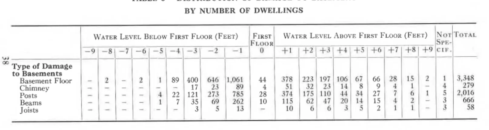
TABLE No. I
DISTRIBUTION OF CHARACTERISTICS OF FLOODED HOUSES' BY NUMBER OF DWELLINGS Dtsrnrcrs 6 Cn-rnecrrnrsrrcs A. Type of House Bungalow 1 |-storey 2-storey Not Classihed Other All Types B. A€,E
Less than 5 yea 5 - 1 0 v e a r s 10-20 years More than 20 years Not Classified Other All Types 163 2 6 1 1 6 54 1 9 5 56 42r I J 1 1 2 2 3 1 9 < A 421 63 / o 229 7 9 522 206 2 9 5 8 . t / l 2 6 4 5 2 1 5 1 A 5 1 4 99 5 3 2 4 5 1 70 48 52 , 2 1 I 1 96 l l 66 32 1 1 390 50 1 1 2 l 39 J l l 1 1 2 4 I 1 1 2 7 2 0 5 1 9
7 r
1 3 0 6 7 2 7 9 5 1 1r82
94 7 7 1 8 J / l 1 3 0 2 4 +3 291 106 63 61. I 522 291 143 I J I , A 5 2 2 184 2 2 263 I 5 2 522 1 1 2 8 +z 54 54 J Ir25
114 39 l . ) t t + 1 i / o l 4 2 9 3 A < t82 42 9 1 5 8 7r 7
7 r
9 6 1 5 2 2 1 9 1 1 34 t 2 7 63 60 2 7 r 72 ,0557+s
36r
a A 1 o ,41+ I , 8 8 3 1,8s0 2 5 7 o / 3 5 7 r L 1 L 2,021 9 7 2,03+ 1 8 244 4,4r4 1,909 1 , 0 1 4 s38 662 291 4,414 3,933 7 7 1 0 393 I 4,41+ 1,050 596 780 383 A 7 1 , 6 3 7 346.)
,414 1 1 1 1 8 460 , 7 A 34 2 3 2 96 2 9 6 1 42t).)
9 1 25 9 I 66 , 2 1 177 148 46 1 0 1 50 522 l 4 63 22 1 8 54 J l l 1 I z 70 194 54 3 1 2 2 3 7 rz6r
2 8 62 2 1 8 371 283 48 3 1 8 1 937r
C, Estimated Value Less than $5,000 $ 5 , 0 0 0 - $ 1 0 , 0 0 0 $ 1 0 , 0 0 0 - $ 1 5 , 0 0 0 More than $ 1 5 , 0 0 0 Not Classified All Types D. Foundations Concrete Stone Posts Slab Not Classified AII Types E. Basement Complete Partial None Duqout Not Classified All Types F. Construction Frame Masonry Both Not Classified Other All Types 191 8 1 1 3 83 5 3 4 2 r .t I 6 3 I z J 20 6 I J l . ' ) 293 2t5 J / 2 1 8 I 293 23 1 3 1 o 0 9 6 7 I+7
J I 20 7 l Ar,r- Drs-TRICTS 526 l z l 1 5 1 1 0 606 2 5 7 207 1 6 5 1 ? ? q 2 5 7 1 7 2 2r,235
J.t4 4t3 103 1 6 169 1 , 2 3 5 5 6 3 Z J 446 3 2 1 7 1 1 , 2 3 5 535 1 3 4 219 1 r , 170 1 ? ? < 1,049 1 0 1 t 7 5 1 , 2 3 5 4,899r , 7 t 4
1,662 7 1 2 7 8,994 ' r 71< 901 1 , 2 2 1 3 , 7 9 r 859 J 8,9943,43r
3,800 6 7 5 t9+ 894 8,994 4 , 2 5 2 8 1 93 , r 7
|
5 5 697 8,994 4,702 1 , s 6 6 860 l , l l l / J J 8,99+ 7 , 7 7 4 2 7 9 36 903 z 8,994TABLE No. 1A
PERCENTAGE DISTRIBUTION OF CHARACTERISTICS OF FLOODED HOUSES Cn-lnacre ntsrrcs A. Type of House Bungalow 1 $-storey 2-storcy Not Classified Other All Types B. ABe Less than 5 5-10 years 10-20 years More than 20 years Not Classified Other All Types C. Estimated Value Less than $5 $5,000-$10,000 $10,000-$15,000 More than $15,000 Not Classifred All Types D. Foundations Concrete Stone Posts Slab Not Classifred All Types E. Basement Complete Partial None Dugout Not Classilied All Types F. Construction Frame Masonry Both Not Classified Other All Types 1 . 4 1 . 2 0.4 0.2 J . Z 1 . 9 0 . 1 0 . 3 0 . 8 0.2 J . J o.4 0 . 1 0 . 1 0.2 0 . 8 0 . 1 0 . 1 0.2 0 . 2 o.2 0 . 8 o.4 0 . 1 0 . 1 0 . 2 0.8
I l2
o . 7 0 . 7 3 . 0 0 . 8 5 . 2 0 . 2 0 . 2 0 . 1 3 . 8 0 . 9 5 . 2 2 . 6 o.2 0.4 0.0 0 . 1 3 . 3 2 . 5 0 . 6 0.0 o.2 0.0 3 . 3 0 . 5 2 . 0 0 . 5 0 . 1 0 . 2 3 . 3 0 . 8 2 : 2 0 . 7 0 . 5 1 . 0 5 . 2 l . J 2 . 7 0.4 0 . 7 J . l 3 . 9 o . 2 0 . 1 0 . 1 0.9 5 . 2 0 . 1 0 . 1 o.4 0.0 0 . 2 0.8 0.2 0 . 1 0 . 1 0 . 2 0 . 2 0.8 0 . 5 0 . 1 0.0 0.2 0 . 8 2 . 7 0 . 2 0 . 1 0 . 1 0 . 2 3 . 3 J . J 0 . 8 0 . 1 0.9 < t Drsrntcrs 34.0 8.3 4.0 2 . 7 0 . 1 49.r tr.7 6.6 8 . 7 t8.2 3 . 8 0 . 1 49.1 20.9 20.6 2 . 8 0 . 8 3.9 49.0 2 2 . 5 l . l 22.6 0 . 2 2 . 7 49.1 21.2 1 1 . 3 6.0 a A 3 . 2 49.r +3.7 0.9 0 . 1 4.+ 0.0 49.r J ) 2 . 0 1 . 0 0.9 o . 2 A 1 3 . 3 2 . 3 1 . 8 0.3 7 . 7 2 . 3 0 . 3 0.8 A 1 0 . 3 7 . 8 1 . 3 0.6 2 . 2 0.6 A 7 0.2 0 . 1 0 . 2 3 . 6 0.6 4 . 7 1 . 5 0 . 7 J . I 0.4 5 . 7 0 . 1 0 . 3 0 . 5 i a 0 . 5 5 . 6 J . / 1 . 1 0 . 6 0 . 3 7 . 7 6 . 7 u . 5 0.0 0.2 0 . 3 / - J 0 . 1 0.0 0.3 7 . 7 3 . 2 1 . 2 o . 7 u . l 0.0 5 . 8 0 . 8 0 . 7 0 . 8 2 . 6 0.9 J . d o . t 2 . 9 2 . 3 1 . 8 13.7 5 . 8 1 i l . t 2.9 1 . 9 0.0 t J - , Ar,r, Drs-TRICTS 54.s 19.0 1 8 . 5 7 . 9 0 . 1 100.0 2 4 . 5 1 0 . 1 r . ) - , 4 2 . 1 9 . 5 0 . 1 100.0 3 8 . 1 42.3 7 . 6 2 . 1 9.9 100.0 47.4 9 . 1 3 5 . 3 0 . 5 100.0 5 2 . 3r7.4
9 . 5 12.4 8.4 100.0 86.5 3 . 2 0.3 10.0 0.0 100.0 1 . 4 0.3 0 . 5 5.9 4.6 1 . 1 0.2 1 . 9 13.7 1 . 3 5 . 1 0.9 0.0 o.4 2 . 6 1 . 1 0.3 0.0 0 . 7 A 7 3 . 2 1 . 6 0.2 0.0 0.8 5 . 8 1 . 7 2 . 8 0.4 0 . 2 0.6 5 . 7 0 . 8 2 . 2 0 . 6 0.3 0.2 4 . 1 6.3 0 . 2 5 . 0 0 . 3 r . 9 13.7 5.9 1 . 5 2 . 4 2 . O 1 . 9 l J . , 2 . 1 0 . 2 2 . 9 0.0 0.6 J . d 2 . 0 1 . 6 0 . 5 1 . 1 0 . 5 .)- / 2 . 9 0 . 3 0 . 7 0.0 0 . 2 4 . 1 3 . 2 0 . 5 0.0 0.2 o.2 i 1 2 . 2 1 L 0 . 7 0.4.)-
/
4.4 0.6 0 . 1 o . 2 0 . 4 J - / 5 . 1 0 . 1 0.0 0 . 5 .)- /r . 7
0.8 1 . 6 0.6 A 1 2 . 1 0.9 0 . 2 0.9 0.6 + . 1 3 . 9 0 . 1 0.0 0 . 7 ^ 1 tr.7 0 . 1 0.0 1 . 9 t3.7 4.9 0 . 2 0 . 7 5 . 8 3 . 6 0 . 2 0 . 1 0 . 2 4 . 1TABLE 2-DISTRIBUTION OF DAMAGE TO MECHANICAL AND ELECTRICAL EQUIPMENT
We'rcn Lever, Below Frnsr Froon (Fnnr) Warrn LBvBr, AsovB Frnsr Fr.oon (Frrr)
+ r l + 2
Type of Heating Forced Hot Air Gravity Hot Air Hot Water Steam Space Heater \adiant Central Not Specified 136 393 116 4 J J
lor
r66 437 r47r 7
I 7 36 40 / J 4 7 z 6 5 1 0 1 , 3 0 1 829 472 3 5 2 704 188)
86 2 80 1 , 4 1 4 J /r08
1,249 I 4 J ' 2 l 8 1 3 0 36 85 44 2 2 2 7 9r87
70 rl7 t87 167 20 34 5 3 8 7 1 8 8 1 6 1 123 / J 1 8 62 l 3 289 t 6 t 4 259 116 1 5 3 48 1 1 3 481,70r
3,374
961 6 1 , 5 0 7 2 1 5 1,428 Torer. Stoker Binfed Hopper Not Specilied Torl'I. Oil Burner Gun Gravity Not Specified 343 495 8 , 1 5 6 1 1 2 3 1 5 1 24 J 1 5 8 1 5 170 76 1 1 1,2t4 8,994 850 102 8,042 8,994 3 , t 7 1 5,823 Torer. lVtring Wiring Not Specified Torel Plumbing Plumbing Not Specified 1 8 5 8r77
I t t , 548 1 6 8 8,994 1,964 7,030 3 8 5 3 3 1 5 1 8 783 BY NUMBER OF DWELLINGS Frnsr Fr.oon 0 l 7 63 1 5 1 8 629 148 216 64 I 203 1 83 373 1 , 1 2 7 250 1 479 1 288 2,519 I J J 2,311 2,519 t49 2 5 I \A,< 2,519 385 2 , t 3 4 2,519 1t6 2,,403 85 40 1 3 2 0 8 r66 6 1 0 1 5 0 t66 79 z 8 5 166 1 5 1 1 5 1 0 A 6 1 1 6 8 6 2 .J J 1 8 1 1 l 6 1 8 1 8 1 8 1 3 5 1 8 1 3 478 22 t 2 444 9 4 63 76 2 8 1 i , t o 70 6 478 7 7 396 8 1 1 , J l 2 726 8 1 1 1 1 0 701 - 6 I I 2 a I I 4 J I 1 I 6 L I 1 3 1 6 + J 2 6 3 5 2 L z 2 z 2 I 2 J 3 3 3 + J 6 1 3 6 43 L 4 1 2 2 2 2 J 43 1 4'.) 2 43TABLE 2A _ PERCENTAGE DISTRIBUTION OF DAMAGE TO MECHANICAL AND ELECTRICAL EQUIPMENT
Type of Heating Forced Hot Air Gravity Hot Air Hot Water Steam Space Heater Radiant Central Not Specified 1 8 . 9 J / . J to.7 0.0 1 6 . 8 0.0 0 . 2 1 5 . 9 To:rer Stoker Binfed Hopper Not Specified Torer, Oil Burner Gun Gravity Not Specified Torel Wirinp Wiring Not Specified Torer Plumbing Plumbine Not Specified t00.0 ! 100.0 3 . 8 90.7 9 . 5 1 . 1 89.4 21.8 78.2 r00.0 3 5 . 3 64.7
Wlrnn Lpvor. Bor,ow Frnsr Fr,oon (Fnnr)
0.0 0.0 0.0 0.0 Frnsr Fr,oon 0 0 . 2 0 . 7 0.2 0.2 l . u 8.3
Wernn Lnvol Aeovn Frnsr Fr.oon (Fenr)
* r l + z I + 3 1
+ 4 1
* 5 1
-1 . s I r . 6 | r . 3 | -1 . 4 -1 0 . 9 | 0 . e 4 . 4 I 2.5 I 1.7 | 0.8 | 0.5 | 0.4 1 . 3 | 0 . 7 | 0 . s | 0 . 2 | 0 . 3 I 0 . 2 t 0 . 0 t t i | -5 . t | 2.2 | 1..3 | 0 . 7 | 0 . 3 | 0 . 2 1 0 . 0 1 l l l-i . z l t o l o s l o l l o . t l o . t
1 4 . 5 1 8 . 0 t 5 . 3 t 3 . 2 N o r I F . 0 . 1 0 . 1 0.0 0.0 0.0 0 . 2 0.0 0.0 0 . 2 - 3 1 . 8 4.9 t . 6 0.2 0.0 0 . 1 0.4 9.0- 6 1 - s
0 . 0 4 . 7 1 2 . 5 2 . 8 0.0 J . J 0.0 28.0 0.8 1 . 5 2 5 . 7 28.0 1 . 6 0.3 2 6 . 1 0 . 1 0.0 0 . 1 0 . 1 0 . 1 0.4 0.0 0.0 0.4 0 . 4 0 . 1 0.3+e
0 . 1 0.0 0.0 0.0 0 . 1 0.0 0.0 0 . 1 0 . 1 0 . 1 0.4 0.2 0 . 1 0 . 1 0.0 0.8 0 . 1 0.0 0 . 7 0.0 0.0 0.0 9 . 0 1 1 5 . 7 1 2 8 . 0 0 . 4 1 0 . 5 | r . 2 8 . 6 t 1 5 . 2 l 2 6 . 8 0 . 0 1 0 . 0 1 0 . 0 1 0 . s i 2 . 19 . 0 | 15.7 I 28.0 0 . 1 0 . 2 0 . 1 0.0 0 . 1 0 . 5 0.0 0 . 1 o.4 0 . 5 0 . 1 0 . 0 0.4 0 . 5 0.8 0 . 5 0.0 0 . 1 0 . 1 0 . 1 2 . 1 0 . 1 0.3 1 . 7 2 . 1 0.3 0.0 1 . 8 2 . 1 0.2 1 . 9 2 . 1 0 . 1 2.0 0.0 0.0 0.0 0.0 0.0 0.0 0.0 0.0 0.0 0.0 1 . 8 1 0 . 8 1 0 . 4 1 . 4 1 0 . 6 1 0 . 2 1 0 . 0 1 0 . 1 0 . 4 1 0 . 2 1 0 . 2 1 0 . 1 l 0 . t 1 . 8 1 0 . 8 1 0 . 4 1 0 . 1 1 0 . 2 8.0 0.7 0 . 1 7 . 2 8.0 6 . 1 1 . 9 8.0 4 . 3 J . / 8.0 5 . 3 I 3 . 2 3 . 3 | 2 . 3 2.0 | 0.9 5.3 I 3.2 Torer, 100.0TABLE 3-DISTRIBUTION OF DAMAGE TO BASEMENT BY NUMBER OF DWELLINGS
Weren LBvBr, Bei,ow Frnsr Floon (FnBr) Frnsr WerBn Lovor, AeovB FInsr Fr-oon (Fner)
R Type of Damage to Basements Basement Floor Chimney Posts Beams Joists +4 4 2 8 1 0 89 2 2 7 400 1 7 12r 3 5 J 66 9 2 7 1 5 z
TABLE 3A-PERCENTAGE DISTRIBUTION OF DAMAGE TO BASEMENT
Frnsr
Fr,oo
0
+4
\oType of Damageto Basement Basement Floor Chimney ' Posts Beams Joists 0.49 0.04 0 . 3 1 0 . 1 1 4.20 0 . 5 7 4 . 1 6 1 . 2 8 0 . 1 1 -l') 2.48 0.36 1 . 9 4 0 . 1 9 0.07
+3
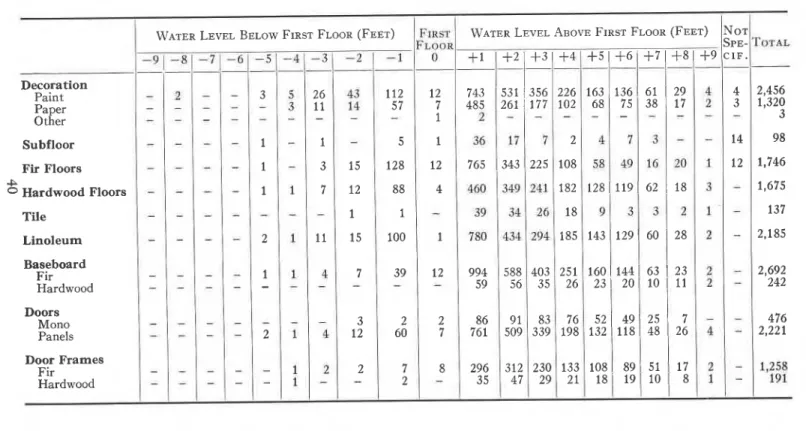
2 . 1 9 o.26 1 . 2 2 0.52 0.07 1 . 1 8 0 . 1 6 0.49 0 . 2 2 0.03 0 . 3 1 0.04 0.08 0.04 0 . 0 1 0 . 1 0 . 0 1 0 . 0 1 0.01 0.04 0.03 0.03 Torel 3 7 . 2 2 3 . 1 0 2 2 . 4 1 7.40 0.64 7 0 3 1 0 . 0 . 0 . 0 . 0 . 7 0 . 1 0 . 0 . 0 0. 0 . 1 7 0.02TABLE 4 - DISTRIBUTION OF DAMAGE TO HOUSE INTERIORS BY NUMBER OF DWELLINGS
WarBn LBvBr, BBr,ow Frnsr Fr,oon (Frnr) N o r SpB-C I F . Decoration Paint Paper Other Subfloor Fir Floors Hardwood Floors Tile Linoleum Baseboard Fir Hardwood Doors Mono Panels Door Frames Fir Hardwood I 1 I a 1 5 t 2 I 1 5 t t 2 2,692 242 A 3 t 4 l 2 2,456 1,320 3 98
r,746
1,675
r37
2,1
85
476 2 , 2 2 1 + 5 128 88 I 100 39 1,,
60
a 3 t 2 2 z o 1 1 1 3 t 1W.crcn Lnvsr Anovn Frnsr Froon (Foer)
+ s t + 6 1 + 7 1 + 8 1 + e
1 6 3 1 1 3 6 1 6 1 1 2 9 6 8 1 7 5 1 3 8 I 1 7 r 2 8 l r r 9 l 6 2 | t8r43lr2el
60 | 28
t 6 o l r 4 4 l 6 3 | 2 3 2 3 1 2 0 1 1 0 1 1 1s z l 4 e l
2 s | 7
r 3 2 l 1 l 8 l 4 8 | 2 6 1 0 8 1 8 9 1 5 1 I 1 7 1 8 1 le l 1 0 | 8+ t l + 2 1 + 3 1 + 4
t 2 7 I 1 t 2 A I 7 4 3 1 5 3 1 1 3 s 6 4 8 5 1 2 6 r l t 7 776s 1343122s
t 2 z a 8 994 59 8676r
296 J J 588 56 9 l 509 5 t z n 7 403 3 5 83 339 230 29 226 102 108 182 1 8 1 8 5 251 2 6 76 198 1 3 3 2 ITABLE 4 - DISTRIBUTION OF DAMAGE TO HOUSE INTERIORS (Continued) BY NUMBER OF DWELLINGS
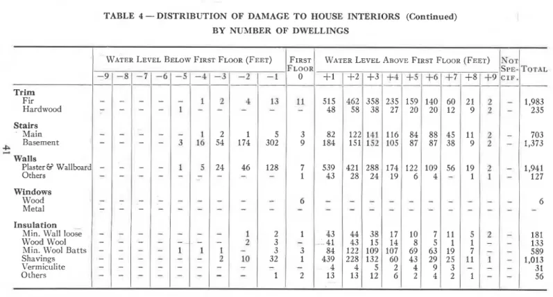
Warnn LBvrr, Brr,ow Frnsr Fr,oon (Frer) WerBn Lovrr, Asovn Frnsr Fr,oon (Fenr)
-LR +J A 1 84 439 A 1 3 235 2 7 1 1 6 105 r74 T 9
+3
3 5 8 38 288 a i 2 1 A 38 1 5 109 132 ( l 2 2 3 32 1 I+ l
Frnsr i l o o n 0 5 1 5 48 Trim Fir Hardwood Stairs- Main Basement Walls Plaster8 Wallboa Others Windows Wood Metal I 174 46 5 302 t28 82 184 539 4 J J 9 7 1 I 3 I 2 6 1 5 9 2 0 84 8 7 122 6 2 l 9 1 1 9 1 9 I 60 t 2 45 3 8 56 140 2 0 88 8 7 1 0 9+
5 I I 1 t 1 1,983 2 3 5 703 I , J ' J 1,941r 2 7
6 1 8 1 133 589 1 , 0 1 3 3 1 5 6 InsulationMin. Wall loose Wood Wool Min. Wool Batts Shavings Vermiculite Others L I 1 A