HAL Id: hal-01343038
https://hal.archives-ouvertes.fr/hal-01343038
Submitted on 7 Jul 2016
HAL is a multi-disciplinary open access
archive for the deposit and dissemination of
sci-entific research documents, whether they are
pub-lished or not. The documents may come from
teaching and research institutions in France or
abroad, or from public or private research centers.
L’archive ouverte pluridisciplinaire HAL, est
destinée au dépôt et à la diffusion de documents
scientifiques de niveau recherche, publiés ou non,
émanant des établissements d’enseignement et de
recherche français ou étrangers, des laboratoires
publics ou privés.
Spatio-temporal metadata filtering and synchronising
invideo surveillance
Dana Codreanu, Vincent Oria, André Péninou, Florence Sèdes
To cite this version:
Dana Codreanu, Vincent Oria, André Péninou, Florence Sèdes. Spatio-temporal metadata filtering
and synchronising invideo surveillance. 31e Conférence sur la Gestion de Données : Principes,
Tech-nologies et Applications (BDA 2015), Sep 2015, Porquerolles, France. pp. 1-5. �hal-01343038�
O
pen
A
rchive
T
OULOUSE
A
rchive
O
uverte (
OATAO
)
OATAO is an open access repository that collects the work of Toulouse researchers and
makes it freely available over the web where possible.
This is an author-deposited version published in :
http://oatao.univ-toulouse.fr/
Eprints ID : 15374
The contribution was presented at :
http://bda2015.univ-tln.fr/
To cite this version :
Codreanu, Dana and Oria, Vincent and Péninou, André and
Sèdes, Florence Spatio-temporal metadata filtering and synchronising in video
surveillance. (2015) In: 31e Conférence sur la Gestion de Données : Principes,
Technologies et Applications (BDA 2015), 29 September 2015 - 2 October 2015
(Porquerolles, France).
Any correspondence concerning this service should be sent to the repository
administrator:
[email protected]
Spatio-temporal metadata filtering and synchronising in
video surveillance
Dana Codreanu
IRIT, University Paul Sabatier Toulouse, France
[email protected]
Vincent Oria
New Jersey Institute of Technology, NJ, USA
[email protected]
André Peninou
IRIT, University Paul Sabatier Toulouse, France
[email protected]
Florence Sèdes
IRIT, University Paul Sabatier Toulouse, France
[email protected]
ABSTRACT
This paper presents an ongoing work that aims at assist-ing videoprotection agents in the search for particular video scenes of interest in transit network. The video-protection agent inputs a query in the form of date, time, location and a visual description of the scene. The query processing starts by selecting a set of cameras likely to have filmed the scene followed by an analysis of the video content obtained from these cameras. The main contribution of this paper is the innovative framework that is composed of: (1) a spatio-temporal filtering method based on a spatio-spatio-temporal mod-eling of the transit network and associated cameras, and (2) a content-based retrieval based method on visual features. The presented filtering framework is to be tested on real data acquired within a French National project in partnership with the French Interior Ministry and the French National Police. The project aims at setting up public demonstrators that will be used by researchers and commercials from the video-protection community.
Categories and Subject Descriptors
H.4 [Information Systems Applications]: Miscellaneous; D.2.8 [Software Engineering]: Metrics—complexity mea-sures, performance measures
Keywords
video-protection framework, spatio-temporal filtering
1.
INTRODUCTION
Public and private locations nowadays rely heavily on cameras for surveillance and the number of surveillance cam-eras in service in public and private areas is increasing. But when needed, the content the surveillance videos is
ana-(c) 2015, Copyright is with the authors. Published in the Proceedings of the BDA 2015 Conference (September 29-October 2, 2015, Ile de Porquerolles, France). Distribution of this paper is permitted under the terms of the Cre-ative Commons license CC-by-nc-nd 4.0.
(c) 2015, Droits restant aux auteurs. Publié dans les actes de la conférence BDA 2015 (29 Septembre-02 Octobre 2015, Ile de Porquerolles, France). Redistribution de cet article autorisée selon les termes de la licence Creative Commons CC-by-nc-nd 4.0.
BDA 2015, 29 septembre au 2 octobre 2015, Ile de Porquerolles, France. ISSN 2429-4586.
lyzed by human agents that have to spend time watching the videos organized in a matrix called video wall. Sev-eral studies have showed the cognitive overload coupled with boredom and fatigue that often lead to errors in addition of the excessive processing time. In that context, the main question is which tools can assist the human agents better do their work?
Many efforts to develop ”intelligent” video-surveillance sys-tems have been witnessed in the past years. The majority of these efforts focused on developing accurate content analy-sis tools [3] but the exhaustive execution of content analyanaly-sis is resource intensive and gives poor results in addition be-cause of the heterogeneity of the video content. The main idea we put forward in this paper is to use the metadata from different sources (e.g., sensor generated data, technical char-acteristics) to pre-filter the video content and implement an ”intelligent” content based retrieval.
When a person (e.g., victim of an aggression) files a com-plaint, she is asked to describe the elements that could help the human agents find the relevant video segments. The main elements of such description are: the location, the date and time, the victim’s trajectory and some distinguishing signs that could be easily noticed in the video (e.g., clothes color, logos). Based on the spatial and temporal informa-tion and on their own knowledge concerning the cameras lo-cation, the surveillance agents select the cameras that could have filmed the victim’s trajectory. Then, the filtered con-tent is visualized in order to find the target scenes, objects (or people) and events.
Based on these observations, the contribution of this paper concerns the video filtering and retrieval. We did an analysis of the current query processing mechanism within the video-surveillance systems that highlighted the fact that the entry point of any query is a trajectory reconstituted based on a person’s positions and a time interval. These elements are used to select the videos of the cameras that are likely to have filmed the scenery of interest. Consequently, the video retrieval is treated as a spatio-temporal data modelling problem. In this context, we have proposed the following elements:
• A definition of the hybrid trajectory query concept, trajectory that is constituted of geometrical and sym-bolic segments represented with regards to different reference systems (e.g., geodesic system, road network);
• A multi-layer data model that integrates data of the road network, the transportation network, the objects movement and the cameras’ fields of view changes; • A set of operators that, given a trajectory query and
a time interval, select the fixed and mobile cameras whose fields of view are likely to have filmed the query trajectory.
2.
RELATED WORK
The video retrieval projects research projects generally focus on developing algorithms based on feature extraction that are exhaustively executed on the available video collec-tions. Very few of them consider a previous video filtering step. In the following we present some of these projects with a focus on content filtering before feature extraction. The CANDELA project proposes a generic distributed ar-chitecture for video content analysis and retrieval [7]. The exhaustive content analysis is conducted in a distributed manner at data acquisition using a number of tools. The CARETAKER project1
investigates techniques allowing au-tomatic extraction of relevant semantic metadata from raw multimedia. Nevertheless, there is no filtering of the content before the feature extraction. More related to our work, the VANAHEIM European project2, based on the human ab-normal activity detection algorithms, proposed a technique for automatically filter (in real time) the videos to display on the video wall screens. Nevertheless, the filtering is based on a video analysis based learning process that supposes the utilization of a big volume of data and that is difficult to implement on a larger scale.
In the following, we present research works aiming at organizing and retrieving visual content based on spatio-temporal information.
[6], proposes a system (SEVA) that annotates each frame of a video with the camera location, the timestamp and the identifiers of the objects that appear in that frame. There-fore this solution can only be applied in a controlled envi-ronment. In [8], an approach similar to SEVA is proposed with the following differences: (1) the objects don’t have to transmit their positions and (2) their objects geometry is considered and not only their localisation. For each second of the video, two external databases (OpenStreetMaps and GeoDec) are queried in order to extract the objects (e.g., buildings, parks) that are located in the filmed scene. The system doesn’t consider spatial queries. [4] is more related to our work and proposes a framework that associates each frame of the video with the geometry of the viewable scene based on metadata collected from GPS and compass sensors. Based on a region query, the framework can return the video sequences that have intersected the video query region. The main difference between their framework and ours is that they don’t address the multimedia retrieval process.
3.
DATA MODEL
We proposed a model that integrates different types of in-formation: (1) The road Network, (2) The transportation Network, and the objects and sensors that move in this en-vironment (3) Objects and (4) Cameras.
1http://cordis.europa.eu/ist/kct/caretaker synopsis.htm 2
http://www.vanaheim-project.eu/
Figure 1: The specification of the proposed operator
Definition 1 : A road network is a non directed graph GR = (E,V) where E = {ei / ei=(vj , vk)} is a set of road segments and V={vi} is the set of segments junctions [5].
Definition 2 : A transportation network GT= (ET,VT) is a non directed graph where VT = vtiis the set of bus station and ET = eti / eti=(vtj , vtk) is a set of transportation network sections.
Definition 3 : Let MO={moi} be the set of mobile ob-ject. Let TR(moi) be the function that extracts the mobile object’s moi trajctory. Let {positionj(moi)} be the set of mobile object’s moipositions. Let {timej(moi)} be the mo-bile object’s moiset of timestamps.
Definition 4 : Let FC={fc}/ fc is a fixed camera, id(fc)=ci gives the camera’s id, position(ci) gives the camera’s posi-tion and fov(ci) extracts the set of it’s field of view changes. Definition 5 : Let MC = {mc} / mc is a mobile camera, id(mc)=cigives the camera’s id, mo(ci)=moi∈MO extracts the mobile object that the camera is attached to. The cam-era’s trajectory will be the mobile object’s one: TR(ci)= TR(mo(ci))).
We define two types of positions: a geometric position that is a 2D position relative to the geodesic system (GPS <lat, long> coordinates) and a symbolic position relative to the underlying layers. We have defined mapping functions that do the connection between the different layers (e.g., compute the position of a bus station or map an object’s trajectory with regards to the road network).
Based on the data model, we define the operator hasSeen that has as input the query defined as a sequence of spa-tial segments (u1, u2,....,un) and a time interval [t1,t2]. The result is a list of cameras likely to have filmed the query’s trajectory with the corresponding time intervals. The spec-ification of the operator is illustrated in figure 1.
4.
THE PROPOSED VIDEOSURVEILLANCE
FRAMEWORK
The Figure 3 illustrates the framework we are proposing in two steps: (1) the spatio-temporal filtering (red workflow in the Figure 3) and (2) the multimedia querying (green workflow in the Figure 3). Let’s use the query illustrated in 2 as a running example.
Figure 2: Query example
4.1
Spatio-temporal filtering
Query Interpreter is the module that is ”translating” the spatial and temporal information given by the user into a spatio-temporal query.
Figure 3: The architecture of the proposed frame-work
SQL Query Generator is the module that based on the spatio-temporal query implements the algorithms 1 and 2. Here are the used methods:
extractCamDist(uk, max(FOV.visibleDistance)):
fixed cameras filtering with regards to the query segments and the maximum visible distance of the cameras in the database.
geometries computation and intersection: compute cam-eras fields of view geometries and generate SQL queries for intersection with the queries segments; the queries are then executed on the Spatio-temporal database.
The schema from Figure 4 illustrates a road network (S1-S5 and S6-S10). The fixed cameras (C1, C2, C3) positions and fields of view are shown. Suppose the query trajectory is TR = S1,S2,S3,S4,S5) (Rivoli Street: Louvre Museum exit -> Subway Chatelet entrance) and the time interval [t1, t2] (January 23rd 2014 between 10h and 12h).
Figure 4: A road network filmed by three fixed cam-eras
The Figure 5 illustrates the different fields of view of the cameras C2 and C3 in time (fov(C2) and fov(C3)). The different moments when the fields of view change are marked with colors corresponding to the geometries from the Figure 4 (e.g., at timej(f ov(C3)) the field of view becomes ABC3).
Figure 5: The moments when the fields of view change and the query interval
The first lines of the algorithm 1 (1-3) represent a filtering step. From all the cameras in the database we will select only those located at a distance smaller than the maximum visible distance from the database. In our case the only cameras that have possibly filmed the query’s trajectory segments are C1, C2 et C3.
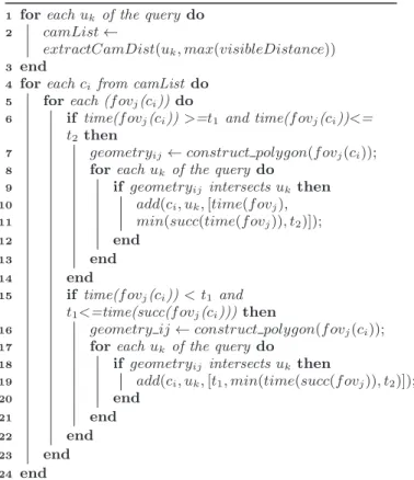
Algorithm 1: Fixed cameras selection
1 for each uk of the query do 2 camList←
extractCamDist(uk, max(visibleDistance))
3 end
4 for each ci from camList do 5 for each (f ovj(ci)) do
6 if time(f ovj(ci)) >=t1 and time(f ovj(ci))<=
t2 then
7 geometryij← construct polygon(f ovj(ci)); 8 for each uk of the query do
9 if geometryij intersects uk then 10 add(ci, uk,[time(f ovj), 11 min(succ(time(f ovj)), t2)]); 12 end 13 end 14 end 15 if time(f ovj(ci)) < t1 and t1<=time(succ(f ovj(ci))) then
16 geometry ij← construct polygon(f ovj(ci)); 17 for each uk of the query do
18 if geometryij intersects uk then
19 add(ci, uk,[t1, min(time(succ(f ovj)), t2)]); 20 end 21 end 22 end 23 end 24 end
For each camera selected at the first step, we will search the periods with changes in the field of view (lines 4,5 of the algorithm 1). The lines 6-19 process the two possible cases: the change is between t1and t2 (e.g., time(f ovk(C2)) or the change is before t1 (e.g., time(f ovj(C3))). The geometries are build and the intersection with the query’s trajectory is evaluated.
The result is:
{(C2, S2, [time(f ovk(C2)), time(f ovk+1(C2))] ), (C2, S3, [time(f ovk+1(C2)), t2])), (C2, S4, [time(f ovk+1(C2)), t2))), (C3, S4, [t1, time(f ovj+1(C3))] )}.
We now consider two mobile objects which trajectories are represented as dotted lines on the figure 4. By mobile object we understand any entity capable of transmitting a period-ically update of its position. Lets suppose that each object sends at least one update mpj (mobile position) containing its position and a timestamp per road segment. By consid-ering each road segment and each mobile object (lines 1-2 of the algorithm 2), the function f ilter(moi, uk,[t1, t2]) will test the possible cases: the object’s position is on the query’s trajectory between t1and t2 (e.g., mpt, mpt, mpj+1, mpj+2 like illustrated in Figure 6) and the preceding position in-tersects also (mpj+1 and mpj+2) or the preceding position doesn’t intersects the trajectory (mpj and mpJ +1) or it in-tersects but before t1 (mptand mpt+1).
The result is: {(obji, S4, [t1,time(mpj+1)]), (obji, S5, [time(mpj+1), t2)], (obji+1, S4, [time(mpt),t2)])}
Figure 6: The mobile object’s trajectory points and the query interval
Algorithm 2: Mobile cameras selection
1 for each ukdo 2 for each moi do
3 listM obileObj← add(f ilter(moi, uk,[t1, t2]));
4 end 5 end
6 for each moi.id from listeObjMobiles do
7 listeCameras← selectionnerCameras(moi.id); 8 end
4.2
The multimedia retrieval
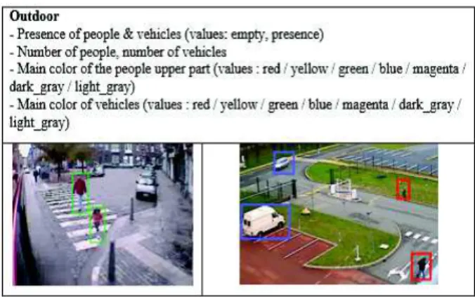
Once the spatio-temporal filtering is done, the video con-tent is analyzed based on the multimedia query engine. Two types of inputs are allowed: (1) textual query (e.g., people dressed in red etc.) and (2) image query. This search is it-erative so for our query example we have the next scenario. The victim remembers that the aggressor was wearing a red coat. The tool that detects people and the main color of their upper body is executed and the first set of results is presented to the user. He watches them and selects a new image query. The image that allowed identification was the one illustrated in the left part of the figure 8.
The LINDO project defined a generic and scalable dis-tributed architecture for multimedia content indexing and retrieval. We used the components of the Video Surveillance server from Paris (described in [1]).
The Access Manager (AM) provides methods for ac-cessing the multimedia contents stored into the Storage Manager. The method the most received from the FEM is String extract(String track, long beginTime, long endTime): starts the processing of a track between the time beginTime and the time endTime.
The Feature Extractors Manager (FEM) is in charge of managing and executing a set of content analysis tools
over the acquired multimedia contents. It can permanently run the tools over all the acquired contents or it can execute them on demand only on certain multimedia contents. The FEM implementation is based on the OSGI framework 3
, the tools or extractors are exported as services and any al-gorithm that respects the input and output interfaces can be integrated. In our implementation we used tools developed by two of the project’s partners4
,5
and that are illustrated in figure 8.
The Metadata Engine (MDE) collects all extracted metadata about multimedia contents. In the case of a tex-tual query, the metadata can be queried in order to retrieve some desired information. The metadata is stored in an XML format presented in [2].
Figure 7: Illustration of the content analysis tools
Figure 8: Example of metadata generated by the color detection tool
5.
CONCLUSIONS
We presented in this paper a video retrieval framework that has two main components: (1) a spatio-temporal filter-ing module and (2) a content based retrieval module (based on a generic framework for indexing large scale distributed multimedia contents that we have developed in the LINDO project).
The generic architecture aims to guide the design of sys-tems that could assist the video surveillance operators in their research. Starting from a sequence of trajectory seg-ments and a temporal interval, such system generates the 3
http://www.osgi.org/Main/HomePage 4http://www.supelec.fr/
5
list of cameras that could contain relevant information con-cerning the query (that ’saw’ the query’s trajectory) then executes some content analysis tools that could automati-cally detect objects or events in the video.
For now, our model considers only outdoor transportation and surveillance networks. We plan to extend our model to indoor spaces also in order to model cameras inside train or subway stations for example.
6.
REFERENCES
[1] M. Brut, D. Codreanu, S. Dumitrescu, A.-M. Manzat, and F. Sedes. A distributed architecture for flexible multimedia management and retrieval. In Proceedings of the 22nd International Conf. on Database and Expert Systems Applications, DEXA’11, pages 249–263, 2011. [2] M. Brut, S. Laborie, A. Manzat, and F. Sedes. A
generic metadata framework for the indexation and the management of distributed multimedia contents. In 3rd International Conf. on New Technologies, Mobility and Security (NTMS), pages 1–5, Dec 2009.
[3] R. Cucchiara. Multimedia surveillance systems. In Proceedings of the Third ACM International Workshop on Video Surveillance and Sensor Networks, VSSN ’05, pages 3–10. ACM, 2005.
[4] B. Epshtein, E. Ofek, Y. Wexler, and P. Zhang. Hierarchical photo organization using geo-relevance. In Proceedings of the 15th Annual ACM International Symposium on Advances in Geographic Information Systems, GIS ’07, pages 1–7, 2007.
[5] K. Liu, Y. Li, F. He, J. Xu, and Z. Ding. Effective map-matching on the most simplified road network. In Proceedings of the 20th International Conference on Advances in Geographic Information Systems, pages 609–612, 2012.
[6] X. Liu, M. Corner, and P. Shenoy. Seva: Sensor-enhanced video annotation. ACM Trans. Multimedia Comput. Commun. Appl., pages 1–26, 2009. [7] P. Merkus, X. Desurmont, E. G. T. Jaspers, R. G. J.
Wijnhoven, O. Caignart, J. f Delaigle, and W. Favoreel. Candela - integrated storage, analysis and distribution of video content for intelligent information systems, 2004.
[8] Z. Shen, S. Arslan Ay, S. H. Kim, and R. Zimmermann. Automatic tag generation and ranking for sensor-rich outdoor videos. In Proceedings of the 19th ACM International Conf. on Multimedia, MM ’11, pages 93–102, 2011.