Geological structure, recharge processes and underground drainage
of a glacierised karst aquifer system, Tsan
fleuron-Sanetsch,
Swiss Alps
Vivian Gremaud&Nico Goldscheider&Ludovic Savoy&
Gérald Favre&Henri Masson
Abstract The relationships between stratigraphic and tectonic setting, recharge processes and underground
drainage of the glacierised karst aquifer system
‘Tsan-fleuron-Sanetsch’ in the Swiss Alps have been studied by means of various methods, particularly tracer tests (19 injections). The area belongs to the Helvetic nappes and consists of Jurassic to Palaeogene sedimentary rocks. Strata are folded and form a regional anticlinorium. Cretaceous Urgonian limestone constitutes the main karst aquifer, overlain by a retreating glacier in its upper part. Polished limestone surfaces are exposed between the glacier front and the end moraine of 1855/1860 (Little
Ice Age); typical alpine karrenfields can be observed
further below. Results show that (1) large parts of the area are drained by the Glarey spring, which is used as a drinking water source, while marginal parts belong to the
catchments of other springs; (2) groundwaterflow towards
the Glarey spring occurs in the main aquifer, parallel to
stratification, while flow towards another spring crosses
the entire stratigraphic sequence, consisting of about 800m of marl and limestone, along deep faults that were
probably enlarged by mass movements; (3) the variability
of glacial meltwater production influences the shape of the
tracer breakthrough curves and, consequently, flow and
transport in the aquifer.
Keywords Karst . Retreating glacier . Multi-tracer test . Climate change . Switzerland
Introduction
The Alps are often considered as the ‘water towers of
Europe’. Just as in most other high mountain areas, annual precipitation is substantially higher than in the surround-ing lowlands; the snow that falls in the cold season is
retained in snowfields and glaciers, from which it is
slowly released during warmer periods to provide large volumes of freshwater to springs, streams, rivers and
aquifers (e.g. Viviroli and Weingartner2004).
Nowhere in Central Europe is climate change so obvious as in the Alps, where rapidly retreating glaciers are the most visible expression of a changing climate
(Greene et al. 1999; Paul et al. 2004). Relatively little
research has been done on the current and future impacts of climate change on the alpine water resources. Available studies suggest that, during the winter, warmer temper-atures and more precipitation in the form of rain instead of snow are likely to result in more available freshwater, while less rain in summer, along with the shrinking or disappearance of glaciers, may result in local, temporary water shortage, particularly in late summer (Kleinn et al.
2005; Schaefli et al.2007; Seidel et al.1998).
There are few places in the Alps where the interrela-tions between climate change, retreating glaciers, ground-water resources and freshground-water supply are so immediate as
in the Tsanfleuron-Sanetsch region in western
Switzer-land, where a rapidly retreating glacier (Tsanfleuron
glacier) directly overlies and recharges the upper part of
a large regional karst aquifer (Fig.1), which is drained at
its lowest point by a spring (Glarey spring) used for the drinking water supply of a community (Conthey), as well as for irrigation purpose. Therefore, a research project was set up to study this alpine glacier and karst aquifer system. Received: 13 November 2008 / Accepted: 12 May 2009
Published online: 16 June 2009
© Springer-Verlag 2009
V. Gremaud
:
N. Goldscheider ())Centre of Hydrogeology, University of Neuchâtel,
Rue Emile-Argand 11, CP 158, 2009, Neuchâtel, Switzerland e-mail: [email protected]
Tel.: +41-32-7182645 Fax: +41-32-7182603 L. Savoy
Hydro-Geol Sàrl,
POB 2430, 2001, Neuchâtel, Switzerland G. Favre
Geologos SA,
16 route de Crassier, 1277, Borex, Switzerland H. Masson
Institut de Géologie et Paléontologie, Université de Lausanne,
A few available studies focus on glacier-groundwater interactions, mostly numerical modelling of large-scale flow beneath recent or Pleistocene ice shields (Flowers et
al. 2003; Boulton et al. 1993), as well as long-term
simulations evaluating the role of infiltrating meltwaters
for the cooling of alpine massifs (Maréchal et al. 1999).
Very few researchers have studied the relations between
alpine glaciers and connected karst aquifers (Smart1996).
The Tsanfleuron-Sanetsch area belongs to a long chain
of karst aquifer systems developed in the Helvetic zone of the Alps, mostly in a Cretaceous limestone formation known as Schrattenkalk (German) or Urgonian (French). Well-studied examples include the Muotathal area, which encompasses the Hölloch, the longest cave in the Alps
(Jeannin2001); the Siebenhengste-Hohgant area with the
second longest cave in the Alps (Häuselmann et al.2003);
and the Hochifen-Gottesacker area, a prime example of a karst system where fold structures were demonstrated to
have a major influence upon the underground drainage
pattern (Goldscheider 2005). The Tsanfleuron-Sanetsch
area, on the other hand, has received little attention from hydrogeologists, while glaciologists and sedimentologists
have studied the glacier and its forefield (Fairchild et al.
1999; Hubbard2002; Hubbard et al.2003; Hubbard et al.
2000).
The relationships between geological structure and underground drainage pattern of this test site were studied
during a first project phase from 2004 to 2008. The
fieldwork included geological mapping, hydrological observations, and 19 tracer injections. The primary goals were to identify the main karst springs, to delineate their
catchment areas and to determine linear groundwaterflow
velocities. The study has also revealed new insights into
the influence of nappe boundaries, folds structures and
deep faults on groundwater flow, as well as insights into
the unique recharge processes in glacierised karst aquifer systems. Furthermore, several observations indicate deep
infiltration into large, gravity-driven flow systems, in
accordance with the conceptual models proposed by Toth
(1963,1999).
On this basis, a second project phase will focus on the
influence of the glacier and snowmelt on the diurnal and
seasonal variability of groundwaterflow and glacier-born
turbidity. The third project phase will aim to make prognoses concerning the possible impact of climate-change induced glacier retreat on aquifer dynamics and freshwater availability.
Geologic setting and karst development
Geologic framework and nappe tectonics
The Tsanfleuron-Sanetsch area belongs to the Helvetic
domain of the Alps and is formed by a pile of several nappes made of Mesozoic and Paleogene rocks, among which limestones play an important role. The region is a
classical example of nappe tectonics (Lugeon 1914). The
present geologic knowledge and terminology were
estab-lished by Lugeon (1940), Badoux et al. (1959, 1990),
Escher et al. (1993) and Steck et al. (1999,2001).
Large parts of the study area are formed by the Diablerets nappe, while the adjacent areas to the N, E
and SE belong to the overlying Mont-Gond nappe (Figs.2
and3). In the study area, the Diablerets nappe is generally
little deformed, while the Mont-Gond nappe has a thin and strongly deformed overturned limb that is connected to the Diablerets nappe by an isoclinal syncline. Its hinge is
clearly discernible south of Tsanfleuron near the Glarey
spring (Fig.3).
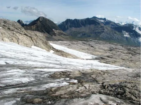
Fig. 1 Impression of the upper part of the Tsanfleuron-Sanetsch area, where the rapidly retreating Tsanfleuron glacier directly overlies and
The basal thrust of the Diablerets nappe follows a Middle Jurassic (Aalenian) clay formation known for its ductility and low permeability (e.g. Crespo-Blanc et al.
1995). The tectonic complex below includes parts of the
Morcles nappe and several other units. The top of the Morcles nappe is formed by thick and clayey Oligocene flysch. For these reasons, it can be assumed that the
Diablerets and Morcles nappes form two separated hydro-geologic systems.
The entire pile of nappes is gently folded and forms a
huge anticlinorium in the Tsanfleuron-Sanetsch area
(Steck et al. 2001). The axial plunge of this structure is
between 5 and 10° to the ENE. The dips of the strata rarely exceed 10° to the NW and 25° to the SE.
Fig. 2 Geologic map of the Tsanfleuron-Sanetsch area (with Swiss coordinates). Large parts of the study area belong to the Diablerets
nappe and mainly consist of Cretaceous Urgonian limestone. The stratigraphy of the over- and underlying nappes is strongly simplified.
Stratigraphy, paleokarst development, and rockfall
The Diablerets nappe below the Tsanfleuron karrenfield
(lapiaz) is ∼1,200 m thick; 150 m are due to tectonic
repetition by an internal low-angle thrust that obliquely
cuts most of the series (Fig. 3). The stratigraphy is well
exposed in the high cliff SW of the lapiaz and comprises Middle and Upper Jurassic, Lower Cretaceous and Tertiary sedimentary formations.
The sequence starts with 60–100 m of Middle Jurassic
(Dogger) black pelites (Aalenian), clayey siltstones,
fine-grained sandstones and calcarenites. The overlying Upper Jurassic and Cretaceous series is principally composed of four limestone formations (two of which are in direct contact) separated by two thick marly formations, de-scribed, from base to top, as follows:
– Massive, micritic limestone of 200 m thickness (Malm) – With a sharp stratigraphic contact follows a 200–250 m thick alternation of marls and mudstones of earliest Cretaceous age (Berriasian)
– This alternation gradually passes into a 150 m thick formation of bioclastic calcarenites (Late Berriasian to Valanginian)
– Above a sharp contact follows 150 m thick siliceous limestone (Hauterivian)
– With clear contact follows a 100 m thick alternation of marls and marly limestones (Early Barremian)
– This alternation passes upwards into the 120-m-thick Urgonian formation (Late Barremian to Early Aptian), consisting of massive and pure limestone that is quite
resistant to mechanical erosion, but highly karstifiable,
as discussed in the introduction
A major stratigraphic gap, resulting from uplift and regression starting at the beginning of the Palaeogene, separates the Urgonian from the overlying Eocene to Oligocene formations. The ensuing erosion removed the entire Upper Cretaceous, leaving the Urgonian lime-stone exposed at the surface. The overlying sediments represent a marine transgression and include, from base to top: sporadic continental (karstic and lacustrine)
deposits; brackish sediments (Weidmann et al. 1991);
shallow marine sandstones and nummulitic limestones
(Menkveld-Gfeller 1994); Globigerina marls; andfinally
flysch, consisting of sandstone with abundant volcanic rock debris. The nummulitic limestone looks similar to
Fig. 3 Cross-sections of the test site area towards the Glarey spring, where the isoclinal syncline connecting the Diablerets nappe and the
Mt. Gond nappe is clearly visible. Note that the Cretaceous stratigraphy is more detailed than in the geological map (Fig.2), which also
the Urgonian limestone and is also karstifiable, but can be distinguished by means of fossils. In the study area, the total thickness of the Palaeogene sediments never exceeds 100 m.
Sporadic but sometimes spectacular paleokarst can be observed both on top and inside the Urgonian limestone. It formed during the continental period preceding the Eocene transgression mentioned above. Paleodolines, karren and solutionally-enlarged fractures
are filled by continental (often residual) sediments such
as fine-grained, iron-rich sandstones (Wieland 1976).
Similar paleokarst phenomena have been studied more
thoroughly in the Morcles nappe (Masson et al. 1980;
Linder 2005).
At its SW margin, the Tsanfleuron karrenfield breaks
off in steep cliffs from 2,900 m to 1,400 m asl, exposing
the entire stratigraphic sequence (Fig. 2). A rockfall of
5 × 10⁶ m3 precipitated from these cliffs in 1714,
destroying the village of Derborance. The Swiss writer C. F. Ramuz wrote a novel about this disaster
(Derbor-ance), but there is little scientific literature available.
Fault tectonics
Fractures of different types and age are numerous in the
study area (Franck et al. 1984). The oldest are
synsedi-mentary, revealed by abrupt variations of layer thickness and, occasionally, by the presence of pebbles and blocks. These fractures were active before and during the
deposition of the Eocene sediments and have influenced
paleokarst development, as demonstrated by paleodolines in the Urgonian limestone aligned along an ENE direction. Paleokarst development was stopped by the marine transgression, and then by the thrusting of the overlying nappes. Kinematic reconstructions suggest a tectonic
overburden of 12 to 14 km (Escher et al.1993).
The Rhône-Simplon Line is a major tectonic disconti-nuity, which follows the Rhône valley and splits into a
number of ENE–WSW to E–W dextral strike-slip faults
(Steck and Hunziker 1994; Steck et al. 1999). Some of
these faults nearly reach the study area such as a
prominent 15 km long fault known as the “CCA fault”,
which has a displacement of 200 m east of Tsanfleuron
and branches westward into a multitude of minor fractures
(Badoux et al. 1959).
In the Tsanfleuron area, just as in the entire region, the
main system of relatively young (i.e. post-nappe) exten-sional fractures and small-scale conjugate shear zones
indicates a stress field with a NW–SE (130–160°)
maximum compression. This stress field is still active
today, as revealed by focal mechanisms of numerous micro-earthquakes recorded along a seismic zone
approx-imately following the CCA fault (Pavoni 1980; Franck et
al. 1984; Pavoni et al. 1997). The influence of this fault
zone on groundwater circulation can be observed in a nearby gallery (Rawil), which encountered a zone of
water-bearing fissures between two dry sectors when
crossing the CCA fault (Badoux1982).
Geomorphologic zones of karst development
The Urgonian limestone outcrops of the Tsanfleuron area
can be subdivided into three zones of karst development, also characterised by different recharge processes (see
Fig.4 and the following). Zone I is where the retreating
glacier overlies the limestone. Zone II is located between the glacier front and the end moraine of 1855/1860, which
indicates the glacier front during the ‘Little Ice Age’
(Greene et al.1999; Hubbard et al.2000). This zone offers
the opportunity to observe limestone recently exposed by
the glacier and to infer the structure of the ice–rock
interface below the glacier. Polished rock surfaces predominate, partly covered by some rock debris repre-senting a thin and patchy melt-out till. There are also meander karren, solutionally enlarged faults, vertical shafts, and large rocky depressions, often hundreds of meters wide and tens of meters deep. Conspicuous elongated calcite crystals on the limestone surface near the glacier front have formed below the ice, as described
by Hubbard and Hubbard (1998).
Zone III, below the end moraine, constitutes a typical
alpine karrenfield that formed since the end of the
Pleistocene glaciations, uninterrupted by the Little Ice Age, similar to many other alpine karst systems. A great variety of karren and other karst landforms can be observed, with a soil and vegetation cover that increases with decreasing altitude. The differences between zones II and III are not only due to the Little Ice Age but also reflect a general change in karst development with altitude and temperature. Small lakes in zone II and small
wetlands in zone III are due to paleodolines filled with
low permeability deposits, as described above.
There are about 100 caves in the area, most of which are very small but some approach 1 km in length. With one exception, none of these caves reaches the active conduit network of the karst aquifer. Although caving teams have done much work, the regional speleological inventory is far from being completed. Most caves developed in Urgonian limestone, but some are also present in Eocene limestone. Cave entrances often consist of vertical shafts, but many caves also include
sub-horizontal passages, parallel to the stratification.
Hydrogeology
Hydrostratigraphy: aquifers and aquicludes
The sequence of aquifers and aquicludes can be inferred from the stratigraphy described above and illustrated in
Fig. 3, complemented by field observations. The most
important aquifer is the pure, competent, intensively
fractured and karstified Urgonian limestone, which
out-crops on large parts of the land surface. The limestone within the locally overlying Eocene and Oligocene
formations is also karstified. Hydrological and
speleolog-ical observations indicate that the two limestones form a connected karst aquifer.
The underlying Barremian marls constitute a regional aquiclude in other parts of the Helvetic zone (e.g.
Goldscheider 2005). However, the thickness of this
formation is only 100 m in the Tsanfleuron area and has
partly been reduced due to tectonic movements as can be
seen in the profile in Fig. 3; furthermore, the vertical
displacements of some faults exceeds the thickness of this formation. Therefore, the hydraulic effectiveness of this formation as an aquiclude is not immediately apparent.
Below the Barremian marls follow Hauterivian sili-ceous limestone, Late Berriasian to Valanginian limestone (bioclastic calcarenites), Berriasian marl, and Malm limestone. In other regions of the Alps and Jura Mountains, the Malm forms a major regional karst aquifer
(e.g. Herold et al. 2000); however, it is not immediately
obvious if the Malm limestone and the Berriasian to
Hauterivian limestones are actually karstified in the
Tsanfleuron region. Karstification requires water
circula-tion, but the entire sequence below the Barremian marls appears to be largely shielded against recharge and
outcrops only in the steep cliffs south of the Tsanfleuron
karrenfields (Fig. 2). However, springs that emerge from
these limestone formations indicate karstification (see the
following). Deep sub-vertical faults might form hydraulic connections from the land surface down towards the deeper limestone aquifers, across the entire stratigraphic
sequence—a hypothesis that was later confirmed by tracer
tests.
Recharge processes
A great variety of recharge processes can be observed in
the Tsanfleuron-Sanetsch area (Fig.4), some of which are
specific to glacierised karst aquifer systems and have
rarely or never been described in the literature. The recharge processes are related to the geomorphologic zones of the Urgonian limestone described above, and are closely linked to the meltwater production and
drainage system of the Tsanfleuron glacier.
Glaciers typically consist of an accumulation zone and an ablation zone. During the past few years, the entire
surface of the Tsanfleuron glacier often acted as an
ablation zone, i.e. the firn line was above the highest
point of the glacier, which means that the glacier is not simply retreating but vanishing. The northern sector of the glacier has a pronounced glacier tongue, and a glacier mouth that gives rise to the principal glacier stream, the Lachon. The southern sector consists of a shallow ice
sheet on top of the karst limestone (Hubbard et al. 2000).
Numerous meltwater streams can be observed at the glacier surface during summer (supra-glacial drainage). Some of them sink into so-called moulins (glacial swallow holes). The moulins in the northern sector are probably connected to the glacier mouth and are thus tributary to the Lachon stream, while those in the southern sector are most likely connected to swallow holes below the glacier, i.e., the meltwater contributes to subglacial point recharge of the karst aquifer. Many paleo-subglacial swallow holes can be observed below the recent glacier front.
The Lachon glacier stream displays significant seasonal
and diurnal discharge variations. Below the glacier mouth,
it first flows over moraine and then over Urgonian
limestone, where it sinks underground via swallow holes at different places, depending on the hydrologic
condi-tions (Fig. 4). Only during the maximum early-summer
snowmelt or storm rainfall does it form a continuous stream, ultimately a tributary of the Rhone River.
In the southern sector, many supra-glacial meltwater streams reach the glacier front, where they join with
emerging subglacial meltwaters that flow at the ice–rock
interface, sometimes as sheet flow. Below the glacier
front, these meltwater streamsfirst flow over limestone for
short distances (typically tens of meters), often via meander karren or over polished rock surfaces, and then sink into swallow holes, often in the form of vertical
shafts (Fig.5). Due to the rapid glacier retreat, this is the
most rapidly changing zone in the entire area.
Similar recharge processes can be observed in the entire zone II during snowmelt or intense rainfall, when
innumerable streams flow over limestone for short
distances before sinking underground via swallow holes. This is a fundamental difference between zone II and zone
III, where all water immediately infiltrates though the
epikarst zone. The diffuse infiltration and percolation of
water through soil and epikarst has already been studied
(e.g. Pronk et al. 2009), while recharge into
glacier-polished limestone has rarely been described in detail. The karst aquifer also receives allogenic recharge from the adjacent non-karst area to the east, mostly via streams that sink underground when they reach the karst area
(Fig. 4). As this zone is used for cattle pasture, the
swallow holes represent a potential source of microbial spring water contamination, as was demonstrated for other
karst systems (Pronk et al.2006).
Main springs
Five main springs drain the Tsanfleuron-Sanetsch karst
aquifer system (Fig.4). Small springs that are not relevant
for regional drainage are not described here.
The Glarey spring—Swiss Coordinates: 589’650;
128’650; altitude: 1,553 m asl—is situated on the axis of
the syncline connecting the Diablerets and Mont-Gond
nappes (Fig.3). It is used as a drinking water source for
the community of Conthey, and for irrigation. Water from the Urgonian-Eocene karst aquifer is captured by means of
a 30-m-long artificial drainage gallery with multiple
branches. In winter, the mean discharge and specific
electrical conductivity (SEC) are 30 L/s and 450 μS/cm,
respectively, while higher mean discharge (180 L/s) and
lower SEC (100 μS/cm) occur during summer, due to
snow and glacier melt; the water temperature is relatively stable at 4°C. When the discharge of the main spring
exceeds 40 L/s, an overflow spring becomes active,
directly discharging into the Lachon stream 100 m upstream of the main spring. Both springs show identical diurnal variations of physicochemical characteristics. The
discharge of the overflow can exceed 3,000 L/s, but has
only been measured continuously by means of a pressure probe since 2008. For earlier years, it is possible to
reconstruct estimates of the overflow discharge using an empirical relation between the discharge of the main
spring and the overflow that has been established in 2008.
Tschoetre spring—585′375; 127′075; 1,500 m—and
Marnes spring—586′070; 127′150; 1,650 m—are located
near the limit between the Malm karst aquifer and the Dogger aquiclude, which outcrops twice due to tectonic
repetition (Fig. 2). Lizerne spring—586′355; 127′195;
1,725 m—discharges from the base of the Valanginian
limestone. The mean annual SEC and temperature of the
Fig. 5 Swallow hole directly below the glacier front in the southern sector of the Tsanfleuron glacier, where it forms a shallow ice sheet.
Due to rapid glacier retreat, new swallow holes are exposed every year, while previously active swallow holes get disconnected from the glacier (photo: N. Goldscheider)
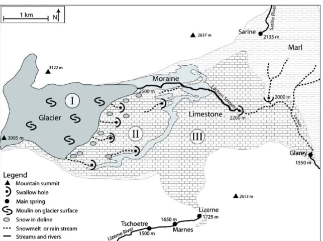
Fig. 4 Generalised hydrological map of the Tsanfleuron-Sanetsch area, showing the glacier and its moulins, the different recharge processes,
the surface streams, swallow holes and springs. Roman numbers indicate the geomorphologic and recharge zones: I limestone covered by glacier, II polished limestone recently exposed by retreating glacier, III typical alpine karrenfield, below the end moraine of 1855/1860
Tschoetre spring are 200μS/cm and 5°C, respectively. As the spring forms a waterfall in a steep gorge, discharge
measurements are difficult. The estimated mean discharge
during summer is 500 L/s. The two other springs directly discharge into the Lizerne stream; measurements of electrical conductivity, temperature and discharge are not available.
The Sarine spring—588′400; 131′900; 2,135 m—is
located north of the Sanetsch pass and seems to discharge from Berriasian marl near the base of the Mt. Gond nappe, not far from the thrust contact to the tectonically underlying Urgonian limestone of the Diablerets nappe. The mean spring discharge is 150 L/s; much higher than could be expected from a marl formation, suggesting
inflow from a karst aquifer. However, the discharge is
stable, and SEC (200μS/cm) and water temperature (3°C)
show no significant variability. All springs show similar
chemical composition, with Ca2+, Mg2+and HCO3−as the
main ions, which is typical for groundwater from limestone and marl stratigraphy.
Tracer tests
Overview and experimental design
Between 2005 and 2008, 19 tracer injections were carried out in the Tsanfleuron area, in order to delineate the
catchments of the five main springs, to determine transit
times and flow velocities, to obtain information about
interactions between the glacier, surface waters and groundwater, and to assess the possible impacts of contaminant releases on the Glarey spring.
Four different fluorescent dyes were used as tracers,
due to their favourable properties (Käss 1998): Uranine,
Sulforhodamine B and G, and Tinopal. Uranine was the preferred choice for single tracer tests, but Sulforhod-amine B or G was used when two injections were too close in time. Uranine and Sulforhodamine B were used for multi-tracer tests with two injection points; Tinopal
was used as the third tracer. Table 1 summarises the
injection points (Nos. 1–19), the tracer types and
quantities, and the experimental conditions. Figure 6
shows the location of the injection points, along with the results that will be discussed in the next section.
Injection No. 1 is the release of Tinopal into a cave
stream that seems to show relatively littleflow variations.
The injection was done by a speleologist. Tracer test No. 2 is the injection of Uranine into the washbasin of the
Prarochet mountain hut. Systematic flushing with tap
water lasted only about 30 min; afterwards, flushing
occurred in an irregular manner, as a function of the use of the washbasin. This tracer test also aimed at assessing the potential impact of the mountain hut on the Glarey spring.
Injection points No. 3–5, 12, 13, 17 and 18 are located
near the southern and eastern margin of the glacier, where
numerous small meltwater streams sink into karstified
limestone. At several other sites, naturallyflowing water is
usually not available. Injection points No. 6–8 are dry
dolines, shafts or inactive swallow holes. For the tracer
injections, several m3offlushing water were delivered by
tank trucks. Sites No. 9 and 10 are inaccessible for vehicles so that the injections were done during rainfall and snowmelt.
On four occasions, a tracer was injected into the main glacial stream (Lachon) at the glacier mouth (injections
No. 11 and 14–16) in order to determine transit times
between the glacier and the Glarey spring during different flow conditions. The main swallow holes are 3 km
downstream (Fig. 4) so the tracers were exposed to
sunlight and, thus, photolytic decay. Therefore, calculated tracer recoveries represent minimum values, as indicated
in Table 1. A degradation experiment at this altitude
revealed an Uranine loss of 40% in 5 h under sunlight. As a function of the different hydrological and meteorological conditions, degradation was lower for injection No. 11 but very high for injection No. 16. Sulforhodamine G, used for injection No. 15, is known to be less sensitive to
daylight (Käss1998). Experiment No. 19 is the injection
of Uranine directly into the main swallow holes of the glacial stream, in order to avoid photolytic decay and to obtain realistic values of tracer recovery.
Springs were sampled for up to three weeks after
injection, which is sufficient in this karst area where
transit times are very short. Automatic samplers (ISCO),
manual sampling, field fluorimeters (GGUN-FL30) and
charcoal bags were used for monitoring. All water and charcoal samples were analysed in the CHYN laboratory (Neuchâtel, Switzerland) with a spectrofluorimeter (Perkin
Elmer LS 50 B). The field fluorimeters measure the dye
concentration in the spring water at user-selectable time intervals ranging from 2 s to 15 min.
Presentation and discussion of the tracer results
Positive results were obtained for all of the 19 tracer tests.
Table 1 presents a summary with the times of maximum
concentration (peak times), the maximum normalised concentrations, the tracer recoveries and the linear
distances between injection and sampling points. Figure6
shows the connections demonstrated by tracer tests, and the peak times.
Only a few tracers arrived at more than one spring at the same time such as the Uranine injected into No. 7, which was detected both at the Glarey spring and the Sarine spring. Most other injection points are connected to
one spring only; furthermore, the tracerflow paths do not
cross each other, i.e., most proven connections are simple point-to-point connections. This helps to delineate the
spring catchment areas, as shown in Fig.6.
The tracer tests demonstrate that the catchment of the
Glarey spring comprises large parts of the Tsanfleuron
karrenfield and glacier, while the four other springs
(Sarine, Marnes, Lizerne, and Tschoetre) drain only very
marginal parts of the karrenfield with very small
contri-bution of the meltwater from the glacier.
The transit times in the conduit system, obtained from the peaks of the breakthrough curves, are very short,
T able 1 Summary of the experimental setup and results of the tracer tests in the T san fl euron area In je ct io n 1 2 3 4 5 6 7 8 9 10 12 13 17 18 19 Date 03 S ep 200 5 18 S ep 200 5 02 A u g 200 6 13 A u g 200 6 15 A u g 200 6 24 J u l 200 7 29 A u g 200 7 30A u g 200 7 11 S ep 200 7 26 J u l 200 8 07 A u g 200 8 26 Au g 200 8 A ltitud e(m ) 2,3 00 2,5 55 2,8 47 2,7 00 2,8 45 2,1 28 2,2 49 2,2 84 2,1 97 2,4 60 2,4 39 2,5 32 2,6 03 2,4 39 2,3 82 2,4 39 2,8 40 2,1 96 2,1 96 T race r T in U r S B S B U r T in Ur SB Ur SB Ur SB T in U r S G U r U r S B U r Mass(g ) 2,0 00 200 450 500 500 2,0 00 300 500 1,0 00 1,0 00 200 500 2,0 00 300 700 600 1,0 00 1,0 00 200 Preci pi tati on -+ + + + + + + + + + + -Sampling site (alt it ude) Results fro m tracer inject ion n˚ Qu a n ti ty (unit ) 12 3 4 5 6 7 8 9 1 0 1 2 1 3 1 7 1 8 1 9 Glarey spri n g (1,553 m ) 2,500 4,400 ND 5,900 ND 2,000 3,150 ND ND ND 5,213 4,945 5,196 4,848 5,213 6,250 ND 2,274 d (m ) 31. 4 54. 8 5 7 33. 0 29. 5 5 .8 10. 3 12. 8 5. 4 15. 3 12. 9 6 .1 t (h ) 88. 8 8 .9 3 70. 5 2 .9 3. 3 31. 4 1 .8 29. 9 7. 4 46. 1 69. 8 ~ 80 ~ 50 ~ 95 ~ 65 ~ 20 ~ 50 ~ 5 ~ 55 ~ 20 ~ 40 ~ 75 R ( % ) Sa ri n e sp ri n g (2,135 m ) ND ND ND ND ND ND ND ND 590 1,227 NS NS ND ND ND X ND ND NS NS NS d (m ) 37. 0 1 1. 5 t (h ) 2. 9 240 0. 8 71. 4 R ( % ) Tsc hoet re sp ri n g (1,500 m ) 2,900 ND 3,100 NS NS NS NS NS ND ND ND NS NS NS ND ND NS d (m ) 16. 2 32. 3 t (h ) 17 21. 2 ~ 47 ~ 35 R ( % ) M arnes (1,650 m ) NS NS NS NS NS NS NS NS XX NS NS NS NS NS NS ND X NS Lizerne sp ri n g (1,725 m ) NS NS NS NS NS NS NS NS XX NS NS NS NS NS NS ND NS NS 11 a 14 a 15 a 16 a 11 a 14 a 15 a 16 a ND c ? b c/ M ( 1 0 -6 m -3 ) ? b c/ M ( 1 0 -6 m -3 ) c/ M ( 1 0 -6 m -3 ) sp ri n g T racers: Ti n T inopal, Ur Uranine, SB/SG Sulforhodamine B/G. Precipitation: –, + and ++ mean no, moderate and intense rainfall, respectively . Results include tracer recovery (R ), time of maximum concentration (t ), normalised maximum concentration (c/M ) and distance (d ). ND sampled but not detected. X connection demonstrated by means of charcoal bags. NS not sampled a Exposure to sunlight and photolytic decay . Recoveries are minimum values b Due to interferences with or ganic carbon, T inopal concentrations and recovery cannot be determined c Due to very high fl ow rates, the main swallow hole of the Lachon stream probably acted as a spring, so that the tracer did not enter the aquifer
ranging from 5.4 to 57 h. The shortest times were observed between the main glacier stream (Lachon) and the Glarey spring (injections No. 11, 15 and 19), suggesting that the principal swallow hole of this stream is connected to a well-developed karst conduit. In the catchment of the Glarey spring, there is no correlation between distance and transit time, which illustrates the high degree of heterogeneity that is characteristic for karst aquifer systems. For example, the tracer injected at site No. 1 took 31.4 h for a 2,500 m linear distance, while
tracer No. 17 took 12.9 h for 6,250 m (Table1; Fig.6).
Tracer recoveries at the Glarey spring (including the
contribution of the overflow), range from ∼5% (No. 12) to
∼96% (No. 4). High recoveries indicate a straightforward conduit connection between the injection point and the spring. Lower recoveries may have different reasons, such as photolytic decay for injections No. 11, 15 and 16, or tracer loss at the injection site due to the absence of
naturallyflowing water (Nos. 6 and 7). However, when a
conservative tracer is directly injected into the conduit network, typically via a swallow hole, recoveries can be used to obtain additional information on the underground flow system. Recoveries lower than 100% mean that the missing part of the tracer and water went elsewhere. In the present case, the low recoveries for some of the injected
tracers may indicate deep infiltration into subvertical
fractures and/or continued flow in the Urgonian karst
aquifer towards the east, where the Diablerets nappe plunges under the tectonically higher nappes.
The rapid connections from injection points Nos. 3 and
5, located at the top of the Urgonian limestone karrenfield
at∼2,850 m altitude, towards the Tschoetre spring, which
discharges from the Malm aquifer at 1,500 m, shows that
deep infiltration via fractures does actually occur across
the entire stratigraphic sequence.
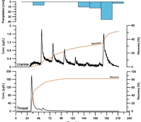
Some breakthrough curves (BTCs) show multiple peaks
with 24-h periodicity, indicating an influence of glacier
melt. Figure 7 presents two BTCs observed at the Glarey
spring during the same multi-tracer test, i.e. during identical hydrological conditions. Uranine was injected into the washbasin of the mountain hut (No. 2), and Tinopal into a cave stream (No. 1). Both tracers arrived at the spring after
about 30 h (time of first detection); the Tinopal BTC
essentially shows a single peak, while Uranine displays at least six peaks in 24-h intervals. It is hypothesised that the Uranine was transported through the unsaturated zone towards an active karst conduit directly connected to the
glacier. The diurnal variability of water level andflow rate
in this conduit causes a stepwise mobilisation of the tracer; intense rainfall on the eighth day seemed to wash out the
remaining tracer, illustrated by an additional and final Uranine peak. Tinopal, on the other hand, was transported in a cave stream far away from the glacier without intermediate storage in the unsaturated zone and without
significant diurnal variability.
The connections from injection points No. 9, 10 and 18 to the Marnes spring were established by very high tracer concentrations found in charcoal bags placed downstream in the Lizerne River. Tracers No. 9 and 10 were also detected in a charcoal bag that was placed upstream from
the spring, but at lower concentration levels. This finding
pointed to the presence of an important spring farther upstream, the Lizerne spring, which was previously unknown.
Although discharge is not monitored at the inaccessible Tschoetre spring, the multi-peak Uranine BTC resulting
from injection No. 5 clearly illustrates the influence of the
diurnal variability of glacier melt on this spring (Fig. 8).
The tracer pathway crosses several unsaturated limestone and marl formations, obviously along deep vertical
fractures, before it reaches the active flow system of the
Marl karst aquifer. Intermediate tracer storage in the
unsaturated zone and periodic flushing by meltwater can
explain the observed BTC.
The tracer injections in the Lachon stream near the glacier mouth made it possible to better characterise the
glacier–stream–aquifer–spring relations during different
hydrologic conditions (Fig. 9). As just described, the
tracers were exposed to daylight between the injection site and the swallow hole so that partial photolytic decay had
occurred. During low-flow conditions (injection No. 16),
the tracer peaked after 15 h but the recovery was only ∼20%, indicating substantial photolytic decay in the slow-flowing surface stream. During high-flow conditions (No. 11), the maximum tracer concentration occurred only 5 h after injection and the recovery was substantially higher (50%) indicating less tracer loss by photolytic decay due to shorter residence times in the stream. Due to the short transit times (the breakthrough was largely completed within about 15 h), the BTC from this injection shows no
discernible influence of the diurnal glacier-melt variations,
unlike the BTCs presented in Figs. 7and8. During very
Fig. 8 Uranine breakthrough curve monitored at Tschoetre spring,
resulting from injection No. 5. The multi-peak behaviour is attributed to the diurnal variability of glacial meltwater production
Fig. 7 Breakthrough curves monitored at the Glarey spring, along with recoveries and daily precipitation, resulting from the injection of
Tinopal (injection No. 1 in Table 1and Fig.6) and Uranine (No. 2) on the same day. Both tracers werefirst detected after about 30 h.
high flow conditions, when little photolytic decay is expected, the tracer did not arrive at the spring, indicating that the swallow holes were not active but probably transformed into springs, i.e. they act as estavelles.
Conceptual model of karst drainage
Based on geological considerations, hydrologic observa-tions and tracer test results, a conceptual model of the underground drainage pattern of this glacierised karst aquifer system was established as illustrated in two
hydrogeological sections (Figs. 10and11).
The Urgonian and Eocene limestones constitute the main regional karst aquifer. The underlying Barremian marl forms an aquiclude, which is, however, relatively
thin (∼100 m). Various processes contribute to aquifer
recharge, including sinking streams from adjacent
non-karst areas (allogenic recharge), diffuse infiltration of rain
and snowmelt water, infiltration of glacial meltwater
underneath the glacier and near its front, as well as sinking of the main glacier stream far downstream from the glacier mouth (autogenic recharge).
Large parts of the area are mainly drained by the Glarey spring, but marginal zones drain towards four other
springs (Fig. 6). Structurally, the aquifer forms a large
anticlinorium with a poorly defined axis and a wide crest,
Fig. 9 Discharge monitored at the Glarey spring and the Lachon stream (if available) during three different tracer tests carried out during
different hydrologic conditions, and resulting Uranine BTCs, monitored at the Glarey spring: a injection No. 16, b injection No. 11 and c
injection No. 14 (see also Table1and Fig.6). During high-flow conditions, shorter transit times and a higher recovery were observed than
during low-flow. During very high flow conditions, the tracer did not reach the spring as the swallow holes were obviously not active. c/M is the uranine concentration normalized by the injected mass
plunging towards the ENE below tectonically higher
nappes, with an axial plunge of 5–10°. The southward
adjacent isoclinal syncline, on the other hand, has a
well-defined axis and forms a narrow trough. The Glarey spring
is located where a deeply incised valley cuts this syncline at a low topographic position (1,553 m).
It is assumed that underground drainage essentially occurs near the base of the shallow karst aquifer, on top of the underlying marl, and follows the fracture network and
the dip of the strata (Fig.10). The karst waters partlyflow
towards the ENE, following the gentle plunge of the anticlinorium, but eventually turn southward, where the isoclinal syncline acts as a major drainage structure, collecting and conveying the water towards the Glarey spring.
Some tracer tests resulted in high recoveries, indicating straightforward connection between the respective swal-low holes and the Glarey spring, via well-developed conduits. Other tracers, although directly injected into the conduit network via swallow holes, reappeared at sub-stantially lower recoveries (sometimes only 5%), suggest-ing that the remainsuggest-ing part of the tracer and, thus, an important part of the water, went elsewhere. It is generally known that high mountain areas often act as recharge zones for large, deep groundwater circulation systems
(Toth 1963, 1999). However, infiltration into these
systems can rarely be directly observed. In the Tsan-fleuron-Sanetsch area, two types of deep infiltration can be
hypothesised, supported by geological and hydrological considerations, and tracer test evidence:
1. Continued groundwater flow in the Urgonian-Eocene
karst aquifer following the general plunge of the Diablerets nappe towards the ENE
2. Deep infiltration via subvertical fractures and faults,
across the relatively thin Barremian marl aquiclude and the underlying formations
The first type can only be indirectly deduced from the
geological structure and the low tracer recoveries, but cannot be observed directly, because the Diablerets plunges below tectonically higher nappes east of the Sanetsch pass and there are no accessible sampling points farther to the east where the re-emergence of groundwater from the study area could be observed.
The second type of deep infiltration, however, is
confirmed by the two positive tracer tests between the
surface of the Urgonian-Eocene karst aquifer and the Tschoetre spring, which discharges from the Malm karst
aquifer, 1,350 m below (Fig. 11). Between the injection
points and the spring, the tracers crossed about 800 m of marl and limestone stratigraphy in less than 2 days, which is only possible via open, subvertical fractures and faults. As a consequence of the steep topography in this part of the area, fractures probably opened by gravitation, enabling rapid water percolation. The catastrophic rockfalls, which plunged
Fig. 10 Conceptual model of karst drainage from the Tsanfleuron glacier and karrenfield towards the Glarey spring, confirmed by tracer
tests (injection points No. 1 and 2 are shown, also see Fig.6). Waterflow occurs near the base of the Urgonian-Eocene karst aquifer on top
of the underlying Barremian marl towards the isoclinal syncline that collects all water and conveys it to the spring. Infiltration into deeper
from these cliffs in 1714 and 1749, further support the supposed existence of open fractures.
Both the Tschoetre and the Glarey springs receive
inflow from the glacier and rapidly react on the
temper-ature-driven diurnal variations of meltwater production. Flow towards the Lizerne and Marnes springs follows pathways similar to those towards the Tschoetre spring, i.e. from the main karst aquifer along fractures across marl aquicludes towards Valanginian and Malm limestone aquifers, respectively.
The Sarine spring, located near the tectonic contact between two nappes, seems to discharge from Berriasian
marl but receives inflow from the Tsanfleuron karst area,
as demonstrated by tracer tests. The crest of the
anticlinorium, although not precisely defined, acts as a
water divide between the catchments of the Sarine spring and Glarey spring. One tracer injection went to both
springs; during high flow conditions, there is also inflow
from the glacier stream to the Sarine spring. The spring is characterised by high but stable discharge, and stable physicochemical parameters. It is hypothesised that the
spring is connected to a karstified limestone imbricate
thrust that drains the surrounding marl aquitards and is also connected to the main aquifer. More research is
necessary to confirm this hypothesis.
Conclusions and outlook
Apart from the immediate relevance of a better under-standing of regional hydrogeology and for the delineation of protection zones for the Glarey spring, the study also allows several conclusions of more general relevance to be
drawn. Groundwaterflow in alpine karst aquifer systems
consisting of marl and limestone formations often follows
the stratification. Therefore, fold structures have a major
influence on groundwater flow in shallow karst systems,
as already demonstrated by means of tracer tests in several
alpine karst systems (e.g. Goldscheider 2005). Butscher
and Huggenberger (2007) used geologic
three-dimension-al modelling in combination with a conceptuthree-dimension-alflow model
approximating underground drainage of shallow karst
systems by open surface flow on top of the underlying
aquiclude. In the Tsanfleuron-Sanetsch karst system, the
Fig. 11 Conceptual model offlow from the upper part of the Tsanfleuron glacier and karrenfield towards the Tschoetre spring, confirmed
by tracer tests (injection point No. 3 is shown; see also Fig.6). The tracer crossed the entire stratigraphic sequence, including several marl
anticlinorium is part of the continental water divide between the catchments of the Rhone and Rhine rivers; the isoclinal syncline acts as a regional drainage structure, conveying water towards the Glarey spring.
Due to the presence of fractures and faults, there is also flow across the stratification. It was possible to
demon-strate rapid flow across an 800 m sequence of marls and
limestone, towards the Tschoetre spring, in less than 2 days. Catastrophic rockfalls occurred in this part of the area in historic times. The tracer tests indicate the presence of open fractures and thus the risk of future rockfalls, enhanced by permafrost thawing and glacier retreat.
Not all recharge water reappears at accessible springs,
but a part of the water feeds deeper and larger regionalflow
systems. In the Tsanfleuron-Sanetsch area, two types of
deep infiltration can be supposed, and partly demonstrated:
(1) parallel to the stratification, following the plunge of the
Diablerets nappe towards the ENE below tectonically
higher nappes, and (2) across the stratification, along
subvertical fractures, at least down to Malm limestone. Intense interactions between the glacier and the karst
aquifer, including specific recharge processes, were
ob-served. The diurnal variations of the glacial meltwater
production influence tracer transport in the aquifer,
con-firming the importance of hydrologic variability for contaminant transport processes in karst aquifer systems
(Göppert and Goldscheider 2008). On the basis of this
study, future research in this test site will focus on a better characterisation of the influence of the diurnal and seasonal
variability of glacier melt upon groundwater flow (and
sediment transport) in the aquifer using simple modelling
approaches (e.g. Fleury et al.2007). Finally, the project will
develop prognoses for the impacts of climate-change induced glacier retreat on the availability and quality of freshwater from the spring.
Acknowledgements The Swiss National Science Foundation has funded the GLACIKARST project since 2004 (grant No. 200020-113609/1). The authors thank the community of Conthey for financial and logistic support, the caving teams for their help, several students and colleagues for their various contributions, particularly J. Nessi, S. Deyres, L. Tobler, K. Spiegelhalter, F. Bourret and R. Costa, and T. Bechtel for proofreading.
References
Badoux H (1982) Des événements de Zeuzier et de la galerie de sondage du Rawyl RN6 [The incidents of Zeusier and the exploration gallery of Rawyl]. Ingénieurs et Architectes Suisses.
Bull Tech Suisse romande 12:155–167
Badoux H, Bonnard EG, Burri M, Vischer A (1959) Feuille St-Léonard et Notice explicative [Map sheet St-St-Léonard with explanatory note]. Atlas géol. Suisse 1:25000, no. 35, Service Géologique National, Bern
Badoux H, Gabus JH, Mercanton CH (1990) Feuille 1285 Les Diablerets [Map sheet 1285, Les Diablerets]. Atlas géol. Suisse 1:25000, no. 88, Service Géologique National, Bern
Boulton GS, Slot T, Blessing K, Glasbergen P, Leijnse T, Vangijssel K (1993) Deep circulation of groundwater in overpressured subglacial aquifers and its geological consequences. Quat Sci
Rev 12(9):739–745
Butscher C, Huggenberger P (2007) Implications for karst hydrol-ogy from 3D geological modeling using the aquifer base
gradient approach. J Hydrol 342(1–2):184–198
Crespo-Blanc A, Masson H, Sharp Z, Cosca M, Hunziker J (1995)
A stable and 40Ar/39Ar isotope study of a major thrust in the
Helvetic nappes (Swiss Alps): evidence for fluid flow and
constraints on nappe kinematics. Geol Soc Am Bull 107
(10):1129–1144
Escher A, Masson H, Steck A (1993) Nappe geometry in the Western Swiss Alps. J Struct Geol (15):501-509
Fairchild I-J, Killawee J-A, Hubbard B, Dreybrodt W (1999) Interactions of calcareous suspended sediment with glacial
meltwater: a field test of dissolution behaviour. Chem Geol
155(3–4):243–263
Fleury P, Plagnes V, Bakalowicz M (2007) Modelling of the functioning of karst aquifers with a reservoir model: application to Fontaine de Vaucluse (South of France). J Hydrol 345(1– 2):38–49
Flowers GE, Bjornsson H, Palsson F (2003) New insights into the subglacial and periglacial hydrology of Vatnajokull, Iceland, from a distributed physical model. J Glaciol 49 (165):257–270
Franck P, Wagner JJ, Escher A, Pavoni N (1984) Evolution des contraintes tectoniques et sismicité dans la région du col du Sanetsch, Alpes valaisannes helvétiques [Evolution of tectonic constrains and seismicity in the Sanetsch region, Helvetic Valais
Alps]. Eclogae Geol Helv 77(2):383–393
Goldscheider N (2005) Fold structure and underground drainage pattern in the alpine karst system Hochifen-Gottesacker.
Eclogae Geol Helv 98(1):1–17
Göppert N, Goldscheider N (2008) Solute and colloid transport in
karst conduits under low- and high-flow conditions. Ground
Water 46(1):61–68
Greene AM, Broecker WS, Rind D (1999) Swiss glacier recession since the little ice age: reconciliation with climate records.
Geophys Res Lett 26(13):1909–1912
Häuselmann P, Otz M, Jeannin P-Y (2003) A review of the dye tracing experiments done in the Siebenhengste karst region (Bern, Switzerland). Eclogae Geol Helv 96(1):23–36
Herold T, Jordan P, Zwahlen F (2000) The influence of tectonic
structures on karst flow patterns in karstified limestones and
aquitards in the Jura Mountains, Switzerland. Eclogae Geol
Helv 93(3):349–362
Hubbard B (2002) Direct measurement of basal motion at a hard-bedded, temperate glacier: Glacier de Tsanfleuron, Switzerland. J Glaciol 48(160):1–8
Hubbard B, Hubbard A (1998) Bedrock surface roughness and the distribution of subglacially precipitated carbonate deposits: implications for formation at Glacier de Tsanfleuron, Switzer-land. Earth Surf Proc Land 23(3):261–270
Hubbard B, Tison JL, Jannsens L, Spiro B (2000) Ice core evidence for the thickness and character of clear facies basal ice: Glacier de Tsanfleuron, Switzerland. J Glaciol 46(152):140–150 Hubbard B, Hubbard A, Tison J-L, Mader HM, Nienow P, Grust K
(2003) Spatial variability in the water content and rheology of
temperate glaciers: Glacier de Tsanfleuron, Switzerland. Ann
Glaciol 37:1–6
Jeannin PY (2001) Modelingflow in phreatic and epiphreatic karst
conduits in the Hölloch cave (Muotatal, Switzerland). Water
Resour Res 37(2):191–200
Käss W (1998) Tracing technique in geohydrology. Balkema, Rotterdam, 585 pp
Kleinn J, Frei C, Gurtz J, Luthi D, Vidale PL, Schar C (2005) Hydrologic simulations in the Rhine basin driven by a regional climate model. J Geophys Res Atmos 110, D04102
Linder P (2005) An Eocene paleodoline in the Morcles Nappe of Anzeindaz (Canton de Vaud, Switzerland). Eclogae Geol Helv 98(1):51–61
Lugeon M (1914) Les Hautes Alpes calcaires entre la Lizerne et la Kander (Wildhorn, Wildstrubel, Balmhorn et Torrenthorn), I [The high limestone Alps between Lizerne and Kander]. Matér. Carte géol. Suisse (N.S.) 30, Francke, Bern, 360 pp
Lugeon M (1940) Feuille Diablerets et Notice explicative [map sheet Diablerets with explanatory note]. Atlas géol. Suisse 1:25000, no. 19, Service Géologique National, Ber
Maréchal JC, Perrochet P, Tacher L (1999) Long-term simulations of thermal and hydraulic characteristics in a mountain massif: the Mont Blanc case study, French and Italian Alps. Hydrogeol
J 7(4):341–354
Masson H, Baud A, Escher A, Gabus J, Marthaler M (1980)
Compte rendu de l’excursion de la Société Géologique Suisse
du 1 au 3 octobre 1979 : coupe Préalpes-Helvétique-pennique
en Suisse occidentale [Minutes of the field trip of the Swiss
Geologic Society on 1–3 October 1979: section of the
Helvetic-Penninic Pre-Alps in western Switzerland]. Eclogae Geol Helv
73(1):331–349
Menkveld-Gfeller U (1994) Die Wildstrubel-, die Hohgant- und die Sanetsch-Formation: Drei neue lithostratigraphische Einheiten des Eocaens der helvetischen Decken [The Wildstrubel, Hohgant and Sanetsch Formations: three new lithostratigraphic units of the Eocene of the Helvetic nappes]. Eclogae Geol Helv
87(3):789–809
Paul F, Kaab A, Maisch M, Kellenberger T, Haeberli W (2004) Rapid disintegration of Alpine glaciers observed with satellite data. Geophys Res Lett 31 (L21)
Pavoni N (1980) Comparison of focal mechanisms of earthquakes and faulting in the Helvetic zone of the Central Valais, Swiss Alps. Eclogae Geol Helv 73(2):551–558
Pavoni N, Maurer H-R, Roth P, Deichmann N et al (1997) Seismicity and seismotectonics of the Swiss Alps. In: Pfiffner AO (ed) Deep structure of the Swiss Alps: results of NRP 20.
Birkhäuser, Basel, pp 241–250
Pronk M, Goldscheider N, Zopfi J (2006) Dynamics and interaction
of organic carbon, turbidity and bacteria in a karst aquifer system. Hydrogeol J 14(4):473–484
Pronk M, Goldscheider N, Zopfi J, Zwahlen F (2009) Percolation
and particle transport in the unsaturated zone of a karst aquifer.
Ground Water 47(3):361–369
Schaefli B, Hingray B, Musy A (2007) Climate change and hydropower production in the Swiss Alps: quantification of
potential impacts and related modelling uncertainties. Hydrol
Earth Syst Sci 11(3):1191–1205
Seidel K, Ehrler C, Martinec J (1998) Effects of climate change on water resources and runoff in an Alpine basin. Hydrol Process
12(10-11):1659–1669
Smart CC (1996) Statistical evaluation of glacier boreholes as indicators of basal drainage systems. Hydrol Process 10(4):599– 613
Steck A, Hunziker J (1994) The Tertiary structural and thermal evolution of the Central Alps: compressional and extensional structures in an orogenic belt. Tectonophysics 238:229–254 Steck A, Bigioggero B, Dal Piaz GV, Escher A, Martinotti G,
Masson H (1999) Carte tectonique des Alpes de Suisse occidentale et des régions avoisinantes 1:100000 [Tectonic map of the western Swiss Alps and neighbouring regions]. Special geological map no. 123, Service Géologique National, Bern
Steck A, Epard JL, Escher A, Gouffon Y, Masson H (2001) Carte tectonique des Alpes de Suisse occidentale et des régions avoisinantes 1:100000. Notice explicative [Tectonic map of the western Swiss Alps and neighbouring regions, explanatory note], Service Géologique National, Bern, 73 pp
Toth J (1963) A theoretical analysis of groundwater flow in small
drainage basins. J Geophys Res 68(16):4795–4812
Toth J (1999) Groundwater as a geologic agent: an overview of the
causes, processes, and manifestations. Hydrogeol J 7(1):1–14
Viviroli D, Weingartner R (2004) The hydrological significance of
mountains: from regional to global scale. Hydrol Earth Sys Sci 8(6):1016–1029
Weidmann M, Franzen J, Berger J-P (1991) Sur l’âge des Couches à
Cérithes ou Couches des Diablerets de l’Eocène alpin [About
the age of the Cerithes or Diablerets formation of the alpine Eocene]. Eclogae Geol Helv 84(3):893–919
Wieland B (1976) Petrographie eozäner siderolithischer Gesteine des Helvetikums der Schweiz: ihre Diagenese und schwache Metamorphose [Petrography of Eocene siderolithic rocks of the Swiss Helvetic zone: their diagenesis and weak metamorpho-sis]. PhD Thesis, Univ. Bern, Switzerland, 117 pp