HAL Id: hal-00963568
https://hal.archives-ouvertes.fr/hal-00963568
Submitted on 11 May 2021
HAL is a multi-disciplinary open access
archive for the deposit and dissemination of sci-entific research documents, whether they are pub-lished or not. The documents may come from teaching and research institutions in France or abroad, or from public or private research centers.
L’archive ouverte pluridisciplinaire HAL, est destinée au dépôt et à la diffusion de documents scientifiques de niveau recherche, publiés ou non, émanant des établissements d’enseignement et de recherche français ou étrangers, des laboratoires publics ou privés.
Nailing down the slip rate of the Altyn Tagh fault
Jiankun He, Philippe Vernant, Jean Chery, Weimin Wang, Shuangjiang Lu,
Wenfei Ku, Wenhai Xia, Roger Bilham
To cite this version:
Jiankun He, Philippe Vernant, Jean Chery, Weimin Wang, Shuangjiang Lu, et al.. Nailing down the slip rate of the Altyn Tagh fault. Geophysical Research Letters, American Geophysical Union, 2013, 40 (20), pp.5382-5386. �10.1002/2013GL057497�. �hal-00963568�
Nailing down the slip rate of the Altyn Tagh fault
Jiankun He,1Philippe Vernant,2Jean Chéry,2Weimin Wang,1Shuangjiang Lu,1 Wenfei Ku,3Wenhai Xia,4and Roger Bilham5
Received 27 July 2013; revised 28 September 2013; accepted 5 October 2013; published 23 October 2013.
[1] Previous estimates of the geodetic and geologic slip
rates of the 1500 km long Altyn Tagh fault bordering the northern edge of the Tibetan plateau vary by a factor of five. Proposed reasons for these discrepancies include poor GPS geometry, interpretative errors in terrace morphology, and changes in fault slip rate over time. Here we present results from a new dense GPS array orthogonal to the fault at ~86.2°E that indicates a velocity of 9.0 3.2/+4.4mm/yr, in
close agreement with geomorphologic estimates at the same location. Our estimated geodetic slip rate is consistent with recent geological slip rates based on terrace offsets. The resulting mean combined geological and geodetic slip rate (9.0 ± 4.0 mm/yr) is remarkably uniform for the central ~800 km of the Altyn Tagh fault, significantly lower than early kinematic estimates and consistent with deformation elsewhere in Tibet and central Asia.Citation: He, J., P. Vernant, J. Chéry, W. Wang, S. Lu, W. Ku, W. Xia, and R. Bilham (2013), Nailing down the slip rate of the Altyn Tagh fault, Geophys. Res. Lett., 40, 5382–5386, doi:10.1002/2013GL057497.
1. Introduction
[2] The slip rate of the Altyn Tagh fault (Figure 1a) is
central to kinematic description of the Himalayan collision process from India to Mongolia [Molnar and Tapponnier, 1975; Avouac and Tapponnier, 1993; Houseman and England, 1993; Peltzer and Saucier, 1996; England and Molnar, 1997; Tapponnier et al., 2001; Gold et al., 2009], yet despite its prominent morphological expression, consid-erable debate has attended quantifying its velocity [Peltzer et al., 1989; Bendick et al., 2000; Mériaux et al., 2004; Zhang et al., 2004; Mériaux et al., 2005; Cowgill, 2007; Zhang et al., 2007; Mériaux et al., 2012]. This is partly due to disagreements in interpretations of the age and offset of geological markers, and partly due to internal deformation within Tibet that adds uncertainty to geodetic interpretations of slip rate using GPS methods. Attempts to reconcile reported velocities include the possibility that changes of rate have
occurred over the past several thousands of years [Washburn et al., 2001; Wallace et al., 2004], or that possible spatial var-iations in elastic loading and fault friction exist [Chéry and Vernant, 2006]. The highest estimates of velocity (~30 mm/yr) [Peltzer et al., 1989; Mériaux et al., 2004] would accommodate more Indo-Asian convergence than the Himalaya [Lavé and Avouac, 2000], leaving negligible convergence to explain deformation within Tibet and NE Asia. In contrast, the low-est low-estimates (~6 mm/yr) [Zhang et al., 2004; Meade, 2007] would require higher slip rates on some faults within the Tibetan plateau (such as the Karakorum-Jiali fault) than is observed [Chen et al., 2004]. Geodetic measurements indicat-ing that the Altyn Tagh fault slips at ~10 mm/yr [Bendick et al., 2000; Wallace et al., 2004; Shen et al., 2001] have been used to support continuum deformation of the Tibetan pla-teau [Zhang et al., 2004; Houseman and England, 1993; England and Molnar, 1997; England and Molnar, 2005], or block like deformation [Meade, 2007; Thatcher, 2007], however, geodetic measurements across the fault have not been measured in the same places as geologic slip rates. Moreover, due to the difficulty in accessing this remote region, previous GPS measurements crossing the northern edge of the Tibetan plateau are sparse and have spanned ~300 km [Bendick et al., 2000] to ~1000 km [Shen et al., 2001] along strike, pos-sibly sampling differences in slip rate [Mériaux et al., 2004; Mériaux et al., 2005].
[3] The highest published geological slip rate (26.9 ±
6.9 mm/yr) [Mériaux et al., 2004] has been reported from longitude 86.4°E where detailed measurements of riser offsets of different geomorphic terraces, using radiocarbon and
10Be-26Al cosmic ray exposure dating of the offset terraces,
have provided a millennial slip rate for the fault [Mériaux et al., 2004; Mériaux et al., 2005; Cowgill, 2007; Gold et al., 2009; Xu et al., 2005]. In order to compare geodetic and geologic slip rate estimates, we have established a GPS profile as close as possible to the site of Mériaux et al. [2004].
2. Data
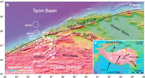
[4] In 2009, we established a 400 km long GPS profile
perpendicular to the Altyn Tagh fault crossing the fault at ~86.2°E (Figure 1b). Seventeen GPS benchmarks with forced antenna centering and an average spacing of 10–20 km were measured 2–3 times between 2009 and 2011, using Trimble NetRS receivers with Zephyr antennae. Observation times for all sites exceeded 48 h during each survey. The GPS data were processed with GAMIT/GLOBK software [Herring et al., 2010] and rotated from the International Terrestrial Reference Frame 2008 (ITRF2008) to a Tarim reference frame by minimizing the velocities of the sites AT12, AT13, and AT16 (Figure 1b). Following Reilinger et al. [2006], we use the“real sigma” algorithm to account for the correlated errors in the time series by calculating a unique noise model for each
1Key Laboratory of Continental Collision and Plateau Uplift, Institute of
Tibetan Plateau Research, Chinese Academy of Sciences, Beijing, China.
2Laboratoire Géosciences Montpellier UMR5243, CNRS Université de
Montpellier II, Montpellier, France.
3Department of Geological Sciences, University of Missouri, Columbia,
Missouri, USA.
4Department of Survey Engineering, Xi’an University of Science and
Technology, Xi’an, China.
5CIRES and Department of Geological Sciences, University of
Colorado, Boulder, Colorado, USA.
Corresponding author: J. He, Key Laboratory of Continental Collision and Plateau Uplift, Institute of Tibetan Plateau Research, Chinese Academy of Sciences, Beijing 100029, China. ([email protected])
©2013. American Geophysical Union. All Rights Reserved. 0094-8276/13/10.1002/2013GL057497
continuous GPS station. Since our sites are only measured episodically, we use the average value of correlated noise model values determined for 320 continuous GPS stations globally distributed with time series spans ranging from 2.5 to 17 years. Hence, we apply a 1-mm/√yr random walk stochastic noise to the survey GPS horizontal time series estimates. One sigma velocity uncertainties are ≤0.9 mm/yr (Table 1). The surface active fault is located 200 m north of the point AT15 (Figure 1b).
[5] In Figure 2a, we show GPS velocities and topography
plotted orthogonal to the fault at 86.18°N and 37.58°E. If outliers are ignored, the data indicate that shear strain caused by slip of the fault at depth is concentrated within a 60 km zone, centered some 15 km south of the surface fault (Figure 2b). Post-seismic signals of the 1999 Mw7.9 Manyi
earthquake may perturb our southernmost two GPS stations, that are<100 km from its surface rupture, but interferometric synthetic aperture radar (InSAR) measurements show that Figure 1. Tectonic setting of the Altyn Tagh fault superimposed on relief map. (a) A simplified view of strike-slip faults around the Tibetan plateau and their deformation sense associated with the current GPS velocityfield relative to Eurasia [Zhang et al., 2004]. Red squared region is the location of Figure 1b. (b) Detailed topographic map around the central portion of the Altyn Tagh fault and GPS velocities relative to the Tarim basin with uncertainties plotted at 95% confidence level.
Table 1. GPS Site Velocities and 1σ Uncertaintiesa
Site Lon. (°N) Lat. (°E) VE(TARIM)(mm/yr) VN(TARIM)(mm/yr) VE(ITRF08)(mm/yr) VN(ITRF08)(mm/yr) σE(mm/yr) σN(mm/yr) Corr.
AT01 86.380 37.413 5.48 1.44 32.09 11.70 0.84 0.87 0.021 AT02 86.327 37.336 7.38 1.59 33.93 11.91 0.82 0.84 0.017 AT03A 86.333 37.213 7.81 2.36 34.26 12.67 0.83 0.86 0.011 AT03 86.309 37.232 10.61 1.81 37.07 12.14 0.79 0.81 0.008 AT04 86.264 36.994 7.52 2.37 33.80 12.76 0.81 0.83 0.013 AT05 86.317 36.575 3.45 1.30 29.40 11.68 0.84 0.86 0.022 AT06 86.250 36.428 7.24 5.02 33.06 15.46 0.80 0.82 0.013 AT07 86.056 36.253 5.74 5.41 31.41 16.04 0.79 0.81 0.011 AT08 86.119 36.026 8.94 2.45 34.43 13.04 0.79 0.81 0.007 AT09 86.283 35.657 9.13 6.58 34.34 17.05 0.79 0.81 0.003 AT10 86.056 35.853 9.29 6.35 34.65 17.01 0.79 0.81 0.007 AT11 86.292 35.376 3.85 5.36 28.83 15.84 0.81 0.83 0.009 AT12b 85.646 37.871 0.93 0.31 27.86 11.21 0.79 0.81 0.005 AT13b 86.011 37.681 0.59 0.14 26.21 10.44 0.82 0.85 0.005 AT14 86.167 37.620 2.53 0.08 29.30 10.53 0.81 0.84 0.004 AT15 86.176 37.581 2.81 0.19 29.55 10.63 0.81 0.84 0.002 AT16b 85.677 38.466 0.26 0.08 27.14 10.77 0.90 0.94 0.025 BJFS 115.892 39.609 8.03 6.61 33.02 11.53 0.50 0.61 0.209 GUAO 87.177 43.471 0.58 2.83 32.00 6.40 0.57 0.74 0.030 HYDE 78.551 17.417 29.59 15.86 40.21 34.59 0.52 0.52 0.072 IISC 77.570 13.021 34.78 14.90 42.14 34.90 1.26 0.81 0.091 IRKT 104.316 52.219 13.97 0.61 23.99 7.19 0.53 0.55 0.050 KIT3 66.885 39.135 0.14 21.05 24.38 5.64 0.58 0.86 0.108 LHAZ 91.104 29.657 27.01 11.94 47.29 18.58 1.57 0.67 0.031 POL2 74.694 42.680 2.85 16.05 25.93 4.38 0.53 0.86 0.096 SELE 77.017 43.179 1.86 13.74 27.80 4.69 0.53 0.59 0.119 TASH 69.296 41.328 5.52 24.17 31.92 0.68 0.53 0.95 0.126 ULAB 107.052 47.865 4.95 1.22 29.14 9.09 0.59 0.80 0.005 URUM 87.601 43.808 0.26 3.55 31.97 5.27 0.60 0.95 0.018 XIAN 109.222 34.369 31.86 17.87 53.92 28.93 0.84 0.89 0.036
aLongitude (Lon.) and latitude (Lat.) are given in degrees east and north, respectively. Velocities and uncertainties are given in mm.yr 1
.
b
The Tarim reference frame is determined by minimizing the horizontal velocities of the three sites on the stable Tarim block (AT12, AT13, and AT16).
most post-seismic deformation is within ~20 km of the sur-face rupture and that the sursur-face displacement following the earthquake obeys an exponential decay with time [Ryder et al., 2007]. Hence, the Manyi earthquake postseismic signal contributes little (<1%) to the interpretation of the Altyn Tagh shear signal. By assuming that the overall veloc-ityfield is related to steady state creep of the Altyn Tagh fault below its locking depth (Figure 2a), we can use elastic dislo-cation theory [Savage and Burford, 1973] to calculate fault slip rate and locking depth.
3. Results and Discussion
[6] The bestfitting solution is obtained with a strike-slip
rate of 9.0 mm/yr, a locking depth of 14.5 km, and a disloca-tion offset 13 km south of the surface fault (Figure 2b). We use the F-ratio test designed by DeMets [1992] specifically to compare thefit of the two Euler poles to a set of directional
data. In this study, we compare thefit of the fault parameters obtained with a forward model to a set of GPS velocity vec-tors. Using a 95% confidence level as the cutoff for signifi-cant differences, the uncertainty on the slip rate is 3.2 and +4.4 mm/yr. We note that our strike-slip-velocity estimate is independent of the locking depth or offset, which are poorly constrained (Figures 2c–2e). The apparent asymmetry of the shear strain relative to the surface fault (Figures 2a and 2b) is intriguing and is similar to results reported from InSAR measurements ~150 km west [Elliott et al., 2008] and ~800 km east [Jolivet et al., 2008] of our profile. Several mechanisms can explain the asymmetry of the interseismic velocity: rheological contrast on two sides of the Altyn Tagh fault, a variation of the elastic crustal thickness [Jolivet et al., 2008], or a southerly dip to the fault. An insignificant step in velocity can be discerned between sites AT04 and AT10, which span the approximate western projection of the Kunlun fault [Tapponnier et al., 2001]. If sites south of AT04 are omitted Figure 2. Sections along the azimuth of 155° across the Altyn Tagh fault at 86.176°E, 37.581°N. (a) Topographic variation normal to the Altyn Tagh fault along the profile and intersismic deformation model of the Altyn Tagh fault, assuming that the fault is a vertical plane creeping at uniform rate below an elastic half space. (b) Fault-parallel velocity component of the GPS measurements. Error bars represent 1σ uncertainty of the GPS velocities relative to Tarim basin, best fit model using an elastic dislocation (blue dotted line), and all the possible models based on the uncertainties (95% confidence, light grey area). (c) Uncertainties for locking depth versus strike-slip rate for the best dislocation offset of 13 km. (d) Uncertainties for locking depth versus dislocation offset for the best strike-slip rate of 9 mm/yr. (e) Uncertainties for dislocation offset versus strike-slip rate for the best locking depth of 14.5 km.
from our solution, a value of 7.9 2.7/+3.4mm/yr is obtained
for the Altyn Tagh fault, within the uncertainty obtained from the bestfitting solution using all the data.
[7] We note that our slip rate (9.0 3.2/+ 4.4 mm/yr) is in
good agreement with the 9.4 ± 2.3 mm/yr slip rate estimated 25 km east of our profile [Cowgill, 2007], where offsets of fluvial terraces were previously interpreted to signify a slip rate of 26.9 ± 6.9 mm/yr [Mériaux et al., 2004]. The low geo-logical rate [Cowgill, 2007; Zhang et al., 2007] assumes that offset started immediately after the abandonment of the upper terraces, whereas the high rate [Mériaux et al., 2004; Mériaux et al., 2005; Xu et al., 2005] follows from assuming that offset offluvial terrace risers corresponds to the time of the abandonment of the lower terrace, an interpretation that we now suggest may be discarded. Thus, if we apply a simi-lar interpretation to offset terraces in other locations along the fault where high rates have been reported [Cowgill, 2007; Gold et al., 2009; Cowgill et al., 2009], wefind that rates es-timated by correlating the riser offsets to the time of upper terrace abandonment are comparable to the geodetic slip rates estimated from InSAR and GPS measurements (Figure 3). The resulting conformity between geodetic and revised geo-logic slip rates leads us to conclude that all the slip rate esti-mates of the Altyn Tagh fault [Bendick et al., 2000; Mériaux et al., 2004; Wallace et al., 2004; Zhang et al., 2004; Mériaux et al., 2005; Cowgill, 2007; Zhang et al., 2007; Elliott et al., 2008; Jolivet et al., 2008; Cowgill et al., 2009] can be reconciled
with an almost uniform slip rate of ~9 mm/yr along much of the fault.
4. Conclusions
[8] When combined with previous GPS estimates [Bendick
et al., 2000; Wallace et al., 2004; Zhang et al., 2004], our new results suggest a remarkably uniform slip rate of ~9 mm/yr along the central ~800 km between 85°E and 94°E of the Altyn Tagh fault. At the eastern end of the fault near the Qilian Shan, the slip rate decreases from ~10 mm/yr to ~1.6 mm/yr [Gan et al., 2007]. The uniform slip relative to the rigid Tarim Basin to the north suggests that negligible deformation is accommodated by the Qiman Tagh Mountains and the western Qiadam basin (Figure 1b). An inferred Indo-Asian convergence direction of N11°E [Zhang et al., 2004] near the central Altyn Tagh indicates that the fault absorbs approximately 5 mm/yr of the 37 mm/yr overall convergence. Approximately, 30–50% of the Indo-Asian convergence is absorbed across the Himalaya [Chen et al., 2004; Zhang et al., 2004], leaving a significant amount of Indio-Asia convergence to be accommodated by contraction of the Tibetan Plateau [Houseman and England, 1993; Zhang et al., 2004] and by deformation in northeast Asia [Calais et al., 2003]. Therefore, our apparent uniform slip rate suggests that the surface carapace of the northern Tibetan plateau moves coherently, consistent with block-like motion of the plateau [Meade, 2007; Thatcher, 2007].
Figure 3. Geologic (black), InSAR (blue), and geodetic slip rates (red) estimated along the Altyn Tagh fault. Error bar rep-resents 1σ uncertainty. The five published geologic slip rates above the dashed line were assumed that the riser offset corre-sponds to the age of the lower terrace abandonment [Mériaux et al., 2004; Mériaux et al., 2005; Xu et al., 2005]. The six published geologic slip rates below the dashed line were assumed that the riser offsets correspond to age of abandonment of the higher terrace [Cowgill, 2007; Zhang et al., 2007; Cowgill et al., 2009; Gold et al., 2009]. Slip rates in the shaded area assumed that the fault offsets (at arrowed places) were formed ~10 ± 2 ka ago [Peltzer et al., 1989]; to bring them into line with the revised velocity for the fault (~9 mm/yr), the assumed age would need to be considerably older. Data are from (1) Peltzer et al. [1989], (2) Mériaux et al. [2004], (3) Xu et al. [2005], (4) Mériaux et al. [2005], (5) Elliott et al. [2008], (6) Zhang et al. [2007], (7) Cowgill [2007]; (8) Gold et al. [2009], (9) Cowgill et al. [2009], (10) Bendick et al. [2000], and (11) Jolivet et al. [2008].
[9] Acknowledgments. We thank Xiongwen Zhang, Dexiao Wu, Jing Wang, and Jiang Lu from Xingjiang Exploration and Climbing Association for thefield logistic assistance. We thank Jeff Freymueller and one anony-mous reviewer for their thoughtful comments. This work was jointly funded by NSF and CAS of China (41030320, KZCX2-EW-116) and the French ANR grant (ANR-07-JCJC-0015).
[10] The Editor thanks Jeffrey Freymueller and an anonymous reviewer for their assistance in evaluating this paper.
References
Avouac, J.-P., and P. Tapponnier (1993), Kinematic model of active defor-mation in central Asia, Geophys. Res. Lett., 20, 895–898.
Bendick, R., P. Bilham, J. T. Freymueller, K. M. Larson, and G. Yin (2000), Geodetic evidence for a low slip rate in the Altyn Tagh fault system, Nature, 386, 61–64.
Calais, E., M. Vergnolle, V. San’kov, A. Lukhnev, A. Miroshnitchenko, S. Amarjargal, and J. De´verche`re (2003), GPS measurements of crustal deformation in the Baikal-Mongolia area (1994–2002): Implications for current kinematics of Asia, J. Geophys. Res., 108(B10), 2501, doi:10.1029/ 2002JB002373.
Chen, Q., J. T. Freymueller, Q. Wang, Z. Yang, C. Xu, and J. Liu (2004), A deforming block model for the present-day tectonics of Tibet, J. Geophys. Res., 109, B01403, doi:10.1029/2002JB002151.
Chéry, J., and P. Vernant (2006), Lithospheric elasticity promotes episodic fault activity, Earth Planet. Sci. Lett., 243, 211–217.
Cowgill, E. (2007), Impact of riser reconstructions on estimation of secular variation in rates of strike-slip faulting: Revisiting the Cherchen River site along the Altyn Tagh fault, NW China, Earth Planet. Sci. Lett., 254, 239–255.
Cowgill, E., R. D. Gold, X. H. Chen, X. F. Wang, J. R. Arrowsmith, and J. Southon (2009), Low Quaternary slip rate reconciles geodetic and geo-logic rates along the Altyn Tagh fault, northwestern Tibet, Geology, 37(7), 647–650.
DeMets, C. (1992), Oblique convergence and deformation along the Kuril and Japan Trenches, J. Geophys. Res., 97, 17,615–17,625.
Elliott, J. R., J. Biggs, B. Parsons, and T. J. Wright (2008), InSAR slip rate determination on the Altyn Tagh Fault, northern Tibet, in the presence of topographically correlated atmospheric delays, Geophys. Res. Lett., 35, L12309, doi:10.1029/2008GL033659.
England, P., and P. Molnar (1997), Active deformation of Asia: From kine-matics to dynamics, Science, 278, 647–650.
England, P., and P. Molnar (2005), Late Quaternary to decadal velocityfields in Asia, J. Geophys. Res., 110, B12401, doi:10.1029/2004JB003541. Gan, W., P. Zhang, Z.-K. Shen, Z. Niu, M. Wang, Y. Wan, D. Zhou, and
J. Cheng (2007), Present-day crustal motion within the Tibetan Plateau in-ferred from GPS measurements, J. Geophys. Res., 112, B08416, doi:10.1029/ 2005JB004120.
Gold, R. D., E. Cowgill, J. R. Arrowsmith, J. Gosse, X. Chen, and X.-F. Wang (2009), Riser diachroneity, lateral erosion, and uncertainty in rates of strike-slip faulting: A case study from Tuzidun along the Altyn Tagh Fault, NW China, J. Geophys. Res., 114, B04401, doi:10.1029/2008JB005913. Herring, T. A., R. W. King, and S. C. McClusky (2010), Introduction to
GAMIT/GLOBK, Release 10.35, Massachussetts Institute of Technology, Cambridge, Mass.
Houseman, G., and P. England (1993), Crustal thickening versus lateral ex-pulsion in the Indian-Asian continental collision, J. Geophys. Res., 98, 12,233–12,249.
Jolivet, R., R. Cattin, N. Chamot-Rooke, C. Lasserre, and G. Peltzer (2008), Thin-plate modeling of interseismic deformation and asymmetry across the Altyn Tagh fault zone, Geophys. Res. Lett., 35, L02309, doi:10.1029/ 2007GL031511.
Lavé, J., and J. P. Avouac (2000), Active folding offluvial terraces across the Siwaliks Hills, Himalayas of central Nepal, J. Geophys. Res., 105, 5735–5770.
Meade, J. (2007), Present-day kinematics at the India-Asia collision zone, Geology, 35, 81–84.
Mériaux, A. S., F. J. Ryerson, P. Tapponnier, J. Van der Woerd, R. C. Finkel, X. Xu, Z. Xu, and M. W. Caffee (2004), Rapid slip along the central Altyn Tagh Fault: Morphochronologic evidence from Cherchen He and Sulamu Tagh, J. Geophys. Res., 109, B06401, doi:10.1029/2003JB002558. Mériaux, A. S., et al. (2005), The Aksay segment of the northern Altyn Tagh
fault: Tectonic geomorphology, landscape evolution, and Holocene slip rate, J. Geophys. Res., 110, B04404, doi:10.1029/2004JB003210. Mériaux, A. S., J. Van der Woerd, P. Tapponnier, F. J. Ryerson, R. C. Finkel,
C. Lasserre, and X. Xu (2012), The Pingding segment of the Altyn Tagh Fault (91E), Holocene slip-rate determination from cosmogenic radionu-clide dating of offsetfluvial terraces, J. Geophys. Res., 117, B09406, doi:10.1029/2012JB009289.
Molnar, P., and P. Tapponnier (1975), Cenozoic tectonics of Asia: Effects of a continental collision, Science, 189, 419–426.
Peltzer, G., and F. Saucier (1996), Present-day kinematics of Asia derived from geologic fault rates, J. Geophys. Res., 101, 27,943–27,956. Peltzer, G., P. Tapponnier, and R. Armijo (1989), Magnitude of Late
Quaternary left-lateral displacements along the north edge of Tibet, Science, 246, 1285–1289.
Reilinger, R., et al. (2006), GPS constraints on continental deformation in the Africa-Arabia-Eurasia continental collision zone and implications for the dynamics of plate interactions, J. Geophys. Res., 111, B05411, doi:10.1029/ 2005JB004051.
Ryder, I., B. Parsons, T. J. Wright, and G. J. Funning (2007), Post-seismic motion following the 1997 Manyi (Tibet) earthquake: InSAR observa-tions and modelling, Geophys. J. Int., 169, 1009–1027.
Savage, J. C., and R. O. Burford (1973), Geodetic determination of the rela-tive plate motion in central California, J. Geophys. Res., 78, 832–845. Shen, Z.-K., M. Wang, Y. X. Li, D. Jackson, A. Yin, D. Dong, and P. Fang
(2001), Crustal deformation along the Altyn Tagh fault system, western China, from GPS, J. Geophys. Res., 106, 30,607–30,621.
Tapponnier, P., Z. Xu, F. Roger, B. Meyer, N. Arnaud, G. Wittlinger, and Y. Jingsui (2001), Oblique stepwise rise and growth of the Tibet plateau, Science, 294, 1671–1677.
Thatcher, W. (2007), Microplate model for the present-day deformation of Tibet, J. Geophys. Res., 112, B01401, doi:10.1029/2005JB004244. Wallace, K., G. Yin, and R. Bilham (2004), Inescapable slow slip on the
Altyn Tagh fault, Geophys. Res. Lett., 31, L06613, doi:10.1029/ 2004GL019724.
Washburn, Z., J. R. Arrowsmith, S. L. Forman, E. Cowgill, W. Xiaofeng, Z. Yueqiao, and C. Zhengle (2001), Late Holocene Earthquake History of the Central Altyn Tagh Fault, China, Geology, 29, 1051–1054. Xu, X., et al. (2005), Late Quaternary sinistral slip rate along the Altyn Tagh
fault and its structural transformation model, Sci. China Ser. D Earth Sci., 48, 384–397.
Zhang, P. Z., et al. (2004), Continuous deformation of the Tibetan Plateau from global positioning system data, Geology, 32, 809–812.
Zhang, P., P. Molnar, and X. Xu (2007), Late Quaternary and present-day rates of slip along the Altyn Tagh Fault, northern margin of the Tibetan Plateau, Tectonics, 26, TC5010, doi:10.1029/2006TC002014.