HAL Id: hal-01092199
https://hal.archives-ouvertes.fr/hal-01092199
Submitted on 10 Dec 2014
HAL is a multi-disciplinary open access
archive for the deposit and dissemination of
sci-entific research documents, whether they are
pub-lished or not. The documents may come from
teaching and research institutions in France or
abroad, or from public or private research centers.
L’archive ouverte pluridisciplinaire HAL, est
destinée au dépôt et à la diffusion de documents
scientifiques de niveau recherche, publiés ou non,
émanant des établissements d’enseignement et de
recherche français ou étrangers, des laboratoires
publics ou privés.
Pleistocene loess of Surduk (Northern Serbia): an
organic isotope geochemistry study
Christine Hatté, C. Gauthier, D. -D. Rousseau, P. Antoine, M. Fuchs, F.
Lagroix, S. B. Markovic, O. Moine, A. Sima
To cite this version:
Christine Hatté, C. Gauthier, D. -D. Rousseau, P. Antoine, M. Fuchs, et al.. Excursions to C-4
vegetation recorded in the Upper Pleistocene loess of Surduk (Northern Serbia): an organic isotope
geochemistry study. Climate of the Past, European Geosciences Union (EGU), 2013, 9 (3),
pp.1001-1014. �10.5194/cp-9-1001-2013�. �hal-01092199�
Clim. Past, 9, 1001–1014, 2013 www.clim-past.net/9/1001/2013/ doi:10.5194/cp-9-1001-2013
© Author(s) 2013. CC Attribution 3.0 License.
EGU Journal Logos (RGB)
Advances in
Geosciences
Open Access
Natural Hazards
and Earth System
Sciences
Open AccessAnnales
Geophysicae
Open AccessNonlinear Processes
in Geophysics
Open AccessAtmospheric
Chemistry
and Physics
Open AccessAtmospheric
Chemistry
and Physics
Open Access DiscussionsAtmospheric
Measurement
Techniques
Open AccessAtmospheric
Measurement
Techniques
Open Access DiscussionsBiogeosciences
Open Access Open Access
Biogeosciences
Discussions
Climate
of the Past
Open Access Open Access
Climate
of the Past
Discussions
Earth System
Dynamics
Open Access Open Access
Earth System
Dynamics
DiscussionsGeoscientific
Instrumentation
Methods and
Data Systems
Open Access
Geoscientific
Instrumentation
Methods and
Data Systems
Open Access DiscussionsGeoscientific
Model Development
Open Access Open Access
Geoscientific
Model Development
DiscussionsHydrology and
Earth System
Sciences
Open AccessHydrology and
Earth System
Sciences
Open Access DiscussionsOcean Science
Open Access Open Access
Ocean Science
DiscussionsSolid Earth
Open Access Open Access
Solid Earth
DiscussionsThe Cryosphere
Open Access Open Access
The Cryosphere
Discussions
Natural Hazards
and Earth System
Sciences
Open Access
Discussions
Excursions to C
4
vegetation recorded in the Upper Pleistocene loess
of Surduk (Northern Serbia): an organic isotope geochemistry study
C. Hatt´e1, C. Gauthier1, D.-D. Rousseau2,3, P. Antoine4, M. Fuchs5, F. Lagroix6, S. B. Markovi´c7, O. Moine4, and
A. Sima2
1Laboratoire des Sciences du Climat et de l’Environnement (LSCE), UMR8212, CEA-CNRS-UVSQ,
91198 Gif-sur-Yvette, France
2Laboratoire de M´et´eorologie Dynamique, UMR8539, CNRS-ENS, 75231 Paris, France 3Lamont-Doherty Earth Observatory of Columbia University, Palisades, NY, USA 4Laboratoire de G´eographie Physique, CNRS-Univ. Paris 1, 92195 Meudon, France 5Department of Geography, Justus-Liebig-University Giessen, 35390 Giessen, Germany
6Institut de Physique du Globe de Paris, Sorbonne Paris Cit´e, Univ Paris Diderot, UMR7154, CNRS, 75005 Paris, France 7Chair of Physical Geography, University of Novi Sad, Novi Sad, Serbia
Correspondence to: C. Hatt´e (christine.hatte@lsce.ipsl.fr)
Received: 10 November 2012 – Published in Clim. Past Discuss.: 11 January 2013 Revised: 12 April 2013 – Accepted: 12 April 2013 – Published: 3 May 2013
Abstract. Loess sequences have been intensively studied
to characterize past glacial climates of the 40–50◦north and south latitude zones. Combining different approaches of sedimentology, magnetism, geochemistry, geochronol-ogy and malacolgeochronol-ogy allows the general pattern of the cli-mate and environment of the last interglacial–glacial cy-cle in Eurasia and America to be characterized. Previous studies performed in Europe have highlighted the predom-inance (if not the sole occurrence) of C3 vegetation. The
presence of C3plants suggests a regular distribution of
pre-cipitation along the year. Therefore, even if the mean an-nual precipitation remained very low during the most ex-tensive glacial times, free water was available for more than 2 months per year. Contrarily, the δ13C record of Surduk (Serbia) clearly shows the occurrence and domi-nance of C4 plants during at least 4 episodes of the last
glacial times at 28.0–26.0 kyr cal BP, 31.4–30.0 kyr cal BP, 53.4–44.5 kyr cal BP and 86.8–66.1 kyr. The C4plant
devel-opment is interpreted as a specific atmospheric circulation pattern that induces short and dry summer conditions. As possible explanation, we propose that during “C4episodes”,
the Mediterranean Sea would have been under the com-bined influence of the following: (i) a strong meridional cir-culation unfavorable to water evaporation that reduced the Mediterranean precipitation on the Balkans; and (ii) a high
positive North Atlantic Western Russian (NA/WR)-like at-mospheric pattern that favored northerlies over westerlies and reduced Atlantic precipitation over the Balkans. This configuration would imply very dry summers that did not al-low C3plants to grow, thus supporting C4development. The
intra-“C4episode” periods would have occurred under less
drastic oceanic and atmospheric patterns that made the influ-ence of westerlies on the Balkans possible.
1 Introduction
Loess deposits are important terrestrial sediment records that provide key data for climate reconstruction and the interpretation of past glacial cycles (Kukla, 1977; Guo et al., 2002). Combining multidisciplinary approaches (sedi-mentology, magnetic properties, geochemistry, geophysics, geochronology, malacology, palynology) allows a general pattern of climatic and environmental evolution in Eurasia and America to be proposed.
In Western Europe, high-resolution study of the Nussloch loess sequence (Germany), supported by a large set of lumi-nescence (OSL, IRSL, TL) and14C dates, has allowed cor-relation of the loess grain size variations and loess–paleosol alternation with the Greenland ice core dust record, which
suggests a global connection between North Atlantic and Western European atmospheric circulations and associated wind regimes (Fuchs et al., 2012; Rousseau et al., 2007). The first attempt to model the impact of the abrupt climate variations of the North Atlantic on dust emissions supports the hypothesis that the North Atlantic millennial-timescale variability is imprinted on Western European loess profiles and points to changes in the vegetation cover as the main factor responsible for the dust emissions, yielding material for millennial-scale sedimentation variations (Sima et al., 2009). Among the multidisciplinary investigations, a recent organic geochemistry study focused on the impact of these abrupt events in terms of precipitation at the key section of Nussloch. Using inverse modeling of δ13C and vegetation, Hatt´e and Guiot (2005) showed a general glacial precipi-tation background of 200 mm yr−1along the last glaciation punctuated by estimated increases of 100 % recorded during interstadial events.
A comprehensive pattern of past Western European mid-latitude atmospheric circulation and interconnection is now emerging, but comparatively few similar high-resolution data on past climate are available for Central Europe. Stratigraph-ical, paleopedological and chronological studies (Antoine et al., 2009a; Fuchs et al., 2008; Galovi´c et al., 2009; Schmidt et al., 2010; Stevens et al., 2011; Zech et al., 2009) in Ser-bia have provided information that the Carpathian region and Western European environments were under different atmospheric conditions that resulted in a drier environment throughout the last climatic cycle (Antoine et al., 2009a; Markovi´c et al., 2008). This conclusion was based on grain-size and paleosol analyses, but a more precise interpretation requires appropriate investigation. Indeed, the extent of this dryness, the search for seasonality of the precipitation and the reconstruction of past vegetation appear necessary for pro-viding key elements for understanding the past atmospheric circulation conditions in this area.
Such an issue could be addressed by an organic isotopic geochemistry study, as has already been performed in West-ern Europe, if properly conducted. Loess sequence is an al-ternation of typical loess and paleosols. These two distinct facies must be considered separately as they yield different types of information. European interglacial paleosols are as-sociated with several millennia of temperate forest vegeta-tion, no or very weak mineral accumulavegeta-tion, temperate hu-mid climate and are the result of strong and efficient pe-dogenesis forming organic soils that can reach up to 2 m in depth (Finke, 2012; Finke and Hutson, 2008; Yu et al., 2013). Roots can penetrate the underlying unaltered sedi-ment (Gocke et al., 2010). By carefully cleaning the ver-tical wall to remove all potential superficial modern vege-tation which can also have laterally penetrating roots, and by conscientiously investigating the sediment to identify and to avoid rhizolith tracks, contamination risks are greatly re-duced. Nevertheless, by precautionary principle, the isotopic signal of soils and paleosols (including Bt horizon) and the
underlying 1 m of sediment should be regarded only as sup-port of climatic trends, not climatic quantitative information. Conversely, typical glacial loess is a suitable sediment for or-ganic geochemistry studies. It accumulates very quickly dur-ing the cold oxygen isotope stage (OIS) and is associated with sparse vegetation and a weak rhizosphere. The presence of centimeter-thick laminated structures recognized in most of the typical loess (Derbyshire and Mellors, 1988; Lautri-dou, 1985; Schwan, 1986) implies the absence of significant vertical disturbance and a good preservation of the memory of the climatic conditions contemporaneous to the time of deposition.
The lack of conditions favorable to pedogenesis and the dry periglacial environment favor the degradation of organic matter without distortion of the isotopic signal, making typ-ical loess suitable for organic geochemtyp-ical study (Hatt´e et al., 1998). Indeed, as corroborated by the very low loess or-ganic content, microbial degradation of the weak and low energetic vegetal input in typical loess during glacial times results in a near-total mineralization of organic matter. This near-complete degradation does not induce isotopic fraction-ation and the original isotopic signal is preserved. In con-trast, flourishing vegetation associated with soils and pale-osols provide a large amount of organic matter with a wide range of energetic value. In such an environment, microbes select compounds of high energetic value at the expense of less easily degradable compounds. This results in a selective degradation of organic matter compounds that might bring in isotopic fractionation. In conclusion, the carbon isotopic composition (δ13C) of organic matter preserved in typical loess sediments nicely reflects the original isotopic signature of the vegetation and, therefore, represents an indicator of paleoenvironmental conditions.
The isotopic signature of vegetation provides information on photosynthetic pathways (C3versus C4)(Farquhar et al.,
1982; O’Leary, 1981) and, thus, on environmental changes that are a prelude to the replacement of one vegetation type by another. Based on physiological studies on plants and on the C4 versus C3 distribution, a replacement of C3 by C4
plants occurs when the C3plants can no longer develop
be-cause of severe environmental changes, such as changes in altitude, temperature, precipitation and wind along with their seasonal patterns. Ecological niche succession follows the rule of “choice of the stronger”. If potential niches of C4and
C3plants overlap, the C3plants will prevail. Austin (1985)
stated that the ecological niche of C4plants is the potential
niche minus the C3overlapping niche. C4plants will expand
when C3plants disappear. C3plants need available water for
at least 2–3 months, according to the species, to complete a growth cycle. In contrast, most C4 plants can complete
a growth cycle in less than 2 months with available water (Paruelo and Lauenroth, 1996).
Working at the bulk (plant) scale justifies the use of empir-ical relationships linking environmental conditions to plant isotopic signatures (concentration and isotopic composition
of atmospheric CO2, water availability and, secondarily,
tem-perature, soil type and texture and insolation) previously es-tablished at this scale (Lloyd and Farquhar, 1994) and not yet available at the molecular scale.
This study presents new geochemical data obtained from the Surduk loess sequence in Serbia and proposes a new envi-ronmental scheme to better understand the past environmen-tal conditions in the south of the Carpathian Basin during the last glacial cycle.
2 Location, sampling and methodology
2.1 Location
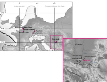
The Surduk loess section is located on the right bank of the Danube River (45◦040N; 20◦200E, ∼ 111 m a.s.l.) in the
southeastern part of the Carpathian Basin ca. 30 km north-west of Belgrade, Serbia (Fig. 1), at the southern edge of the European loess belt.
The area is characterized by the occurrence of thick loess– paleosol sequences that mainly outcrop in quarries but also as high loess cliffs along the left bank of the Danube River and at the confluence between the Danube and tributaries, includ-ing the Tisa River east of the Titel Plateau (Fig. 1). Today, the site is mostly under a Mediterranean climate influence, with winter occurring from November to February. The average annual temperature is 10.9 °C. In January, the average tem-perature is −1◦C and in July it is 21.6◦C. The annual rainfall is ca. 690 mm, and there are ca. 120 rainy days (Klein Tank et al., 2002). The area does not undergo very strong season-ality with a dry summer season and/or a long and cold winter (Fig. 2). This implies a region covered by plants with a car-bon C3fixation pathway. Less than 2 % of vascular plants in
southeast Europe are C4plants (Pyankov et al., 2010).
2.2 Sampling
All stratigraphic studies and high-resolution samplings were carried out on a 20 m-high vertical loess cliff over a period of 15 days. Due to stability and security problems, the up-per 3 m of the section was sampled in a trench excavated from the top above the vertical profile. The work began with the careful cleaning (removal of weathered material) of the whole section to provide a highly detailed stratigraphical pro-file (Fig. 3, stratigraphy). This cleaning step is crucial for or-ganic geochemistry to prevent any pollution by oror-ganic ma-terial, which can be found, according to the sediment tex-ture, as far as 0.5 m below the exposed surfaces. This ma-terial can be the product of bacma-terial activity in the coarser sediment, nets of burrowing insects or the illuviation of or-ganic compounds in topsoil through cracks. Removal from at least 1 m below the vertical wall reduces the contamination risk. Furthermore, measuring the nitrogen content of the sam-pled sediment checks a posteriori for the absence of modern organic matter. As nitrogen is mostly linked to amino acids
50°N 45°N Alpine ice-‐cap 20°E 0 10°E 55°N Bri5sh ice-‐sheet Nussloch Achenheim Be/encourt-‐Saint-‐Ouen Saint-‐Saufflieu Villiers-‐Adam Sava Danube 50 km Crvenka Petrovaradin Miseluk Ruma Irig Cirikovac Klenovnik Batajnica Stari Slankamen Surduk Tisza Fennoscandinavian ice-‐sheet
Fig. 1. Location of the Surduk loess sequence. Other series relevant
to this study and mentioned in text are also shown.
that rapidly decrease with organic matter degradation, a mea-surable level of nitrogen implies the input of recent organic matter into the sediment.
The sampling methodology used in Surduk for the geo-chemistry was based on the continuous column sampling (CCS) method developed by the team several years ago when investigating Western European loess sequences. This method consists of cutting a continuous vertical column (±5–7 cm width) through the whole loess–paleosol se-quence, which is then sliced every 5 cm to produce 376 ho-mogeneous samples of sediment. The CCS method allows the geochemistry to be averaged every 5 cm, preventing any gap between the different samples as usually occurs when taking a succession of isolated samples. A single sample was subdivided into four for grain-size, carbon content and δ13C and14C determination. This division allows the correlation of independent environmental proxies. More information on the CCS and on the Surduk sampling is available in Antoine et al. (2009a,b).
Sediment sampling is performed while preventing contact with any organic material, which means no hand contact with the sample at any time and no contact with paper or any po-tential pollutant, including smoke. Samples are preserved in zipper PE plastic Minigrip® bags with no VOC emission. We chose to sample a large amount of sediment (approxi-mately 50 g), even though only some 100 mg is necessary for geochemical analysis. This process “dilutes” any poten-tial contamination that would still have subsisted after all the precautions we took. Following this protocol is absolutely necessary for the quality requirement of the investigation of sediment with such a low amount of organic carbon (typi-cally 0.1 %wt) (Gauthier and Hatt´e, 2008).
Jan uar y Fe br uar y Mar ch Ap ril Ma y Ju ne July Au gu st Se pt em be r Oct obe r No vemb er De ce mbe r !" #!" $!" %!" &!" '!!" (" )" *" +" *" (" (" +" ," -" ." /"
precipita5on October-‐ January (mm)
0 200 400 600 800 mm 40 45 50 55 60°N -‐10 0 10 20 30°E precipita5on February-‐May (mm) 0 200 400 600 800 mm 40 45 50 55 60°N -‐10 0 10 20 30°E precipita5on June-‐September (mm) 0 200 400 600 800 mm 40 45 50 55 60°N -‐10 0 10 20 30°E
Surduk average rainfall (mm)
pr ec ip ita5 on (m m ) 100 60 40 20 0 80 !"#$ #$ "#$ %#$ &#$ '#$ te m pe ra tu re (°C ) 40 20 10 0 -‐10 30
Average High Temp.
Average Low Temp.
Fig. 2. Modern annual precipitation distribution in Europe with a focus on Surduk. Upper panels and the lower left panel are for modern
cumulative precipitation from February to May (panel upper left), June to September (panel upper right) and October to January (panel lower left). Scale is in mm. Note that the Surduk region (red square) does not undergo dry summer season. Focus on Surduk area (lower right) with the 1946–2006 average precipitation (histogram) and high (orange line) and low (blue line) temperature recorded at Cortanovci (45◦090N, 20◦010E), the closest meteorological station to Surduk.
2.3 Geochemistry methodology
The sediment samples were dried at low temperature as soon as possible to ensure safe storage, as recommended by Gau-thier and Hatt´e (2008). After being sieved at 250 µm to re-move stones and being homogenized, the sediment then un-derwent a soft leaching process to remove carbonate using pre-combusted glass beakers, HCl 0.6 N at room tempera-ture, ultra-pure water and drying at 50◦C. The samples were then crushed in a pre-combusted glass mortar for homoge-nization prior to carbon content and δ13C analysis. The han-dling and chemical procedures are common precautions em-ployed with low-carbon-content sediments.
2.3.1 Organic and carbonate content
Two different carbon measurements were performed for ev-ery sediment sample: total carbon for the bulk sediments and organic carbon for the leached sediments. Approximately 15 to 20 mg of sediment was weighed in tin cups for mea-surement (with a precision of 1 µg). The sample was com-busted in a Fisons Instrument NA 1500 Element Analyzer, and the carbon content determined using the Eager soft-ware. A standard was inserted every 10 samples. The inor-ganic carbon content in the bulk sediment was calculated by
assuming that mineral carbon exists only as CaCO3. The
re-sults are reported in %weight of carbonate/bulk sediment and in %weight of organic carbon/bulk sediment.
2.3.2 Carbon isotopic signature
Analysis was performed online using a continuous flow EA-IRMS coupling, that is, a Fisons Instrument NA 1500 Element Analyzer coupled to a ThermoFinigan Delta+XP Isotope-Ratio Mass Spectrometer. Two in-house standards (oxalic acid, δ13C = −19.3 % and GCL, δ13C = −26.7 %) were inserted every five samples. Each in-house standard was regularly checked against international standards. The results are reported in the d notation:
δ13C = (Rsample/Rstandard−1) · 1000,
where Rsample and Rstandard are the 13C/12C ratios of the
sample and the international standard, Vienna Pee Dee Bee (VPDB), respectively. The measurements were at least tripli-cated for representativeness. The external reproducibility of the analysis was better than 0.1 %, typically 0.06 %. Extreme values were checked twice.
2.4 Geochronology methodology
2.4.1 IRSL dating
Ten samples were taken for infrared stimulated lumines-cence dating (IRSL) using copper cylinders (±4 cm diame-ter), which were hammered into the loess section to avoid any contamination by light-exposed material. Additional material was taken from the 30 cm surrounding every IRSL sample for dose rate determination. The sample preparation of the polymineral fine grain fraction (4–11 µm), the luminescence measurements and the dose rate determination are explained in detail in Fuchs et al. (2008).
2.4.2 14C dating
Based on the δ13C results, 15 samples were selected for
14C dating. The14C activity evaluation was performed using
AMS physical measurements taken at the Australian ANSTO (ANUA numbers), the NSF-Arizona AMS Lab (AA num-bers) and the French LMC14 (SacA numnum-bers) facilities. The CO2gas was prepared using three different protocols chosen
according to the type of sediment. The protocol from Hatt´e et al. (2001c) (HCl 0.6 N, Na4P2O7 0.1 M and HCl 1 N at
room temperature) was applied for typical loess sediment, whereas either protocol from Hatt´e et al. (2001b) (HCl 0.6 N, Na4P2O70.1 M, K2Cr4O70.1 M/H2SO42 N at room
temper-ature) was applied to sediment extracted from gleys under N2
flow to avoid possible incorporation of modern CO2during
alkali treatment by adsorption on Fe2+.
All 14C measurements were converted to calendar ages using Calib 6.0, which includes the IntCal09 calibration (Reimer et al., 2009).
3 Results
3.1 Geochronology
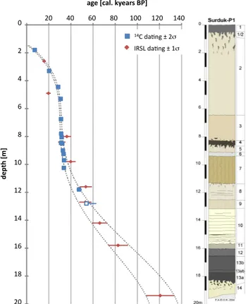
All geochronological data are reported in Tables 1 and 2 and are shown with their stratigraphic position in Fig. 3. Within errors, the14C and IRSL dates are in good agreement. Some classical discrepancies remain only because14C and lumi-nescence dating do not characterize the same event.14C dat-ing estimates the time elapsed since the death of the plant that trapped the dust, while luminescence estimates the time elapsed since the grains to be dated were without the influ-ence of sunlight. Both chronologies cannot be directly com-pared, especially for recent times during which external pa-rameters that are at the origin of the discrepancy may be larger than the uncertainties of the physical measurement (Fuchs et al., 2008).
The largest discrepancy between organic radiocarbon and mineral luminescence chronologies occurs between a 400 and 600 cm depth (Fig. 3), where the organic chronology has a relatively uniform sedimentation rate. The mineral IRSL
20 40 60 80 100 120 140 age [cal. kyears BP]
0 2 4 6 8 10 12 14 16 18 20 de pth [m] 14C da5ng ± 2σ IRSL da5ng ± 1σ
Fig. 3. Stratigraphy and age model of the Surduk loess sequence.
Red diamonds are for IRSL dating; the error margin encompasses the 1 sigma variation range (Fuchs et al., 2008). Blue squares repre-sent Calib 6.0 calibrated14C dating (Reimer et al., 2009); the error margin encompasses the 2 sigma variation range. The open symbol represents the > 53 00014C conv. year, for which we only have a minimum age. The dotted lines represent an age model envelope that should very likely encompass the chronology of the loess or-ganic accumulation. Major stratigraphic units are 14: Saalian loess; 13–12: basal soil complex; 11–10: lower loess; 9–4: middle soil complex; 3–2: upper loess; and 1: top soil (Antoine et al., 2009a).
would indicate a rupture in the sedimentation at the onset of the major loess accumulation. This discrepancy may be the result of the intrinsic nature of both chronologies: vegetation at the origin of the organic matter used for the analysis of the C chronology was present all along this interval, whereas mineral accumulation occurred by pulses (Sima et al., 2009). The organic chronology is thus smoother than the mineral chronology. Nevertheless, the shift is approximately 9 kyr, and smoothing cannot be the only explanation. Another ex-planation could be an IRSL underestimate of sample BT141 for reasons so far unknown.
Although the intent of the chronological framework is to place organic geochemical signal in time, we favored the
14C dating to draw an outline that should encompass the
most likely chronological organic framework of the sequence (Fig. 3).
0 2 4 6 8 10 12 14 16 18 20 !"#$#% !"&$#% !"'$#% !""$#% !!"#$%&'$ () '*% +$+% +$#% )$+% )$#% "$+% +% "++% &++% ,++% -++% )+++% )"++% )&++% ),++% )-++% "+++% (#)*+$%(,-'$ ./ 0-1$ %2 3 $4* )3 $-1/ $-)0'$ *./ 0% +% )+% "+% '+% &+% #+% ($#5#6"$%(,-'$ *1* 2 '% 10 20 30 40 50 60 70 80 90 100 110 120 Age model [kyears] Depth
[m from the top]
fracCon higher than 63µm [%] 0 10 20 30 40 grai n s ize > 63 µm Stra5graphical units (Antoine et al. 2009)
Stra5graphical units (Antoine et al. 2009a): unit 14: Saalian loess; units 13-‐12: Basal soil complex; units 11-‐10: Lower loess; units 9-‐4: Middle soil complex; units 3-‐2: Upper loess; unit 1: Top soil
Fig. 4. Geochemical data of the Surduk loess sequence. The stratigraphical description is from Antoine et al. (2009a). Blue, green, orange
and violet curves represent grain sizes greater than 63 µm in %, organic carbon content in %wt, carbonate content in %wt and δ13C of loess organic matter in ‰ vs. PDB, respectively. All data are presented versus depth. On the right axis, a non-linear timescale is presented based on IRSL and14C dates. Horizontal bars highlight C4episodes. Major stratigraphic units are 14: Saalian loess; 13–12: basal soil complex;
11–10: lower loess; 9–4: middle soil complex; 3–2: upper loess; and 1: top soil (Antoine et al., 2009a).
We thus face a very high accumulation during the Mid-dle Pleniglacial with 600 cm (from 1050 to 450 cm depth) as an imprint of 10 kyr (between 37 and 27 kyr) corresponding to an average sedimentation rate of 1.7 mm yr−1. This pat-tern appears to be unusual, as the highest sedimentation rates are generally observed in European loess during the Upper Pleniglacial (±OIS 2) and upper Middle Pleniglacial (OIS 3) (Fuchs et al., 2008).
3.2 Geochemistry
All geochemical data are presented in Fig. 4. The or-ganic carbon and carbonate contents are both within the classical ranges observed throughout European loess se-quences. These contents respectively vary between 0.2 %wt and 20 %wt, with approximately 4 %wt of organic carbon maximum for modern soil associated with the lowest carbon-ate content of approximcarbon-ately 8 %wt. The lowest organic con-tent (0.06 %wt) corresponds to the highest carbonate concon-tent (40 %wt) during the offset of the penultimate glacial period.
Typical values of the last glacial periods are 0.15 %wt and 20 %wt, respectively.
The δ13C signature in Surduk varies from −25.1 ‰ for the roots of the modern soil to −22.4 ‰ at a 445 cm depth. Such a scheme is outside the current pattern measured in Western Europe, where isotopic values are always lighter than −23.5 ‰. The heaviest δ13C record during the last glacial time in the Nussloch (Upper Rhine Valley, Ger-many), Villiers-Adam (Ile-de-France, France), Bettencourt-Saint-Ouen and Saint-Saufflieu (Picardy, France) loess se-quences are −23.5 ‰, −23.9 ‰, −24.1 ‰ and −24.1 ‰, re-spectively (Hatt´e, 2000; Hatt´e et al., 1998).
The isotopic organic record of the Achenheim sequence (Alsace, France) is not considered here, as it was perturbed by both periglacial features and inadequate sample preser-vation; its highest recorded value was −23.1 ‰ (outside the periglacial perturbation) (Hatt´e et al., 1998). Likewise, we do not consider the −16.9 ‰ values obtained by Pustovoy-tov and Terhorst (2004) in Schattenhausen near Nussloch in some tundra gley horizons, which inexplicably have the lightest δ13C in typical loess.
Table 1. Chronological data of the Surduk loess sequence: IRSL age determinations (Fuchs et al., 2008). The first two columns are for sample
identification; columns 3 to 5 are for U, Th and K contents; columns 6 and 7 are for effective dose rate (DL) and equivalent dose rate (De); and last columns are for IRSL estimated age (±1 sigma). Further information in Fuchs et al. (2008).
U Th K DL De IRSL age
Depth [m] Sample # [ppm] [ppm] [%] [Gy ka−1] [Gy] [yr] [±1σ ] 2.6 BT 140 3.0 ± 0.1 9.8 ± 0.5 1.4 3.2 ± 0.3 50.4 ± 2.4 15 800 1600 4.9 BT 141 3.4 ± 0.1 10.8 ± 0.5 1.4 4.0 ± 0.4 77.8 ± 3.7 19 700 2100 8 BT 142 3.5 ± 0.1 11.8 ± 0.5 1.6 4.0 ± 0.4 145.2 ± 6.2 36 300 3900 8.4 BT 143 3.5 ± 0.1 12.5 ± 0.5 1.6 3.7 ± 0.4 117.5 ± 6.1 31 800 3400 9.8 BT 144 3.7 ± 0.1 12.3 ± 0.6 1.6 4.1 ± 0.4 161.6 ± 9.1 39 800 4500 11.6 BT 145 3.2 ± 0.1 11.1 ± 0.4 1.6 3.6 ± 0.4 190.6 ± 8.1 53 400 5600 12.7 BT 146 3.1 ± 0.1 11.1 ± 0.5 1.6 3.6 ± 0.4 188.8 ± 7.7 53 100 5500 14.2 BT 147 3.4 ± 0.1 11.6 ± 0.5 1.7 3.8 ± 0.4 247.9 ± 10.6 66 000 7000 15,8 BT 148 3.5 ± 0.1 12.2 ± 0.5 1.7 3.9 ± 0.4 321.5 ± 16.1 82 600 9000 19.4 BT 149 3.0 ± 0.1 10.5 ± 0.6 1.4 3.2 ± 0.3 391.9 ± 16.4 120 700 12 800
Table 2. Chronological data of the Surduk loess sequence:14C dating. The specificity of the chemical treatment prior to CO2evolvement and the14C activity measurement is provided in a reference column. The14C results are shown as conventional14C and calibrated14C ages based on the Calib 6.0 calibration (Reimer et al., 2009), for which minimum, maximum and median ages are given.
14C conventional age Calibrated age ±2σ [3]
Physical Chemical age ±1σ min max median Depth [m] Chemistry # measurement # treatment ref. [yr] [yr] [yr] [yr] [yr] 1.8 GifA-050011 ANUA-31418 [1] 6.400 190 6.855 7.620 7.295 3.3 GifA-070129 AA-78959 [2] 17.135 85 20.060 20.555 20.335 4.45 GifA-070128 AA-78958 [2] 23.740 145 28.005 29.025 28.490 5.3 GifA-050013 ANUA-31419 [1] 26.000 330 30.235 31.195 30.735 6.75 GifA-050014 ANUA-31420 [1] 26.500 370 30.455 31.445 31.040 7.8 GifA-080225 SacA-13476 [3] 26.775 530 30.320 32.195 31.210 8.05 GifA-070127 AA-78957 [2] 27.550 175 31.300 32.175 31.635 8.45 GifA-050015 ANUA-31421 [1] 26.640 340 30.605 31.520 31.135 8.5 GifA-050016 ANUA-31423 [3] 27.870 440 31.310 33.180 32.145 9 GifA-080224 SacA-13475 [3] 28.360 645 31.460 34.245 32.740 9.25 GifA-070126 AA-78956 [2] 28.950 180 33.020 34.460 33.355 9.7 GifA-080223 SacA-13474 [3] 29.335 725 31.875 35.125 33.800 10.25 GifA-080222 SacA-13473 [3] 29.145 710 31.805 34.935 33.630 11.8 GifA-070123 AA-78953 [2] 44.025 1.350 45.230 49.850 47.320 12.8 GifA-070124 AA-78954 [2] >53 000
[1]: AAA under air; [2]: AAA under N2; [3] : Calib 6.0; [3]: ABOx (see text for AAA and ABOx definitions).
The Surduk δ13C record differs from the other Euro-pean loess geochemical records not only by the heavi-est isotopic episode reaching −22.4 ‰ at a 445 cm depth (ca. 28.0–26.0 kyr cal BP) but also by three other episodes of heavy δ13C values recorded at 675 cm (−22.8 ‰, ca. 31.4–30.0 kyr cal BP), 1240 cm (−22.6 ‰, ca. 53.4– 44.5 kyr cal BP) and a plateau between 1535 and 1500 cm at
−22.85 ‰ (ca. 86.8–66.1 kyr BP).
Carbon isotope fractionation by C3plants depends on the
atmospheric CO2 concentration and isotopic composition
and on the humidity level (Farquhar et al., 1989; O’Leary, 1981). As a consequence the current δ13C range for all
modern C3 plants of [−31; −24 ‰] (Deines, 1980) might
have been shifted towards less negative values during glacial arid periods. Based on a mechanistic vegetation model that simulates carbon isotopic fractionation of vegetal biome, Hatt´e et al. (2009) showed that isotopic niches of dwarf shrub tundra and shrub tundra, the expected biomes during glacial times, shifted from [−32; −28 ‰] under present conditions to [−31; −26.5 ‰] under glacial times (assuming 220 ppm of CO2). Thus, if values lighter than approximately −23.5 ‰ were interpreted as exclusively resulting from the degrada-tion of C3plants (Hatt´e et al., 2001a), those of −22.4 ‰ to −22.85 ‰ likely derive from the degradation of combined
C4 and C3 plants. Furthermore, C4-derived organic carbon
decomposes faster than its C3 counterpart in mixed C3/C4
environments (Wynn and Bird, 2007), leading to a shift to-wards more negative values of the sediment organic δ13C by comparison with the plant mixture δ13C. This might be of importance in typical loess environment where mineral accumulation rates are high. Therefore, the presence of C4
plants can also be invoked for the events recorded at 825 cm (−23.1 ‰) and at 1200 cm (−22.9 ‰) that occurred during the 32.9–30.7 cal kyr and 50.4–42.0 cal kyr intervals, respec-tively.
A C4/C3plant mixture does not imply that both plants
co-habited. Plants with both photosynthetic pathways can have occurred successively during the period represented by the sampling interval, i.e., over ca. 250 yr (in the case of the
−22.4 ‰ value). As the paleoprecipitation reconstruction by inverse modeling of BIOME4 was only validated for C3
plants (Hatt´e and Guiot, 2005), no quantitative paleoprecipi-tation can be estimated from the δ13C signal.
4 Discussion
4.1 General last climatic cycle trend
The geochemical records clearly match the classical pattern of the last climatic cycle, with a higher organic carbon con-tent and the lowest δ13C during the equivalent to OISs 5, 3 and 1. The carbonate content follows the same pattern, with a lower carbonate content for warmer episodes (OISs 5, 3 and 1) as the result of carbonate leaching during pedogenesis.
According to both the organic chronology and the δ13C record, Surduk’s last interglacial and early glacial periods cover more than 2 m, from a depth of ca. 1850 to 1600 cm (Fig. 3, units 14 to 12). The Upper Pleniglacial covers the upper part of the sequence from 825 cm to the upper top, the uppermost meter being crossed by a few deep root tracks down to 200 cm from the Holocene humic topsoil horizon (Fig. 3, units 3 to 1). The boundary between the Lower and Middle Pleniglacial is more difficult to establish. Fuchs et al. (2008) and Antoine et al. (2009a) placed the limit at ap-proximately 1300 cm (Fig. 3, boundary between units 10 and 9), whereas the organic record would push the climatic pe-joration, the equivalent of OIS 4 (boundary between units 8 and 7), to 1150 cm at the offset of the heaviest δ13C values.
Aside from the isotopic excursions toward heavy values, the Surduk loess sequence remains roughly within the same
δ13C range as other European loess sequences. This result implies drastic climatic conditions along the last glacial cycle that favored C3 plants for most of the time. The expected
level of precipitation should likely be approximately 200– 300 mm yr−1with respect to other loess sequences, and the C3predominance leads to free meteoritic water distributed
along the warm season for most of the last glacial period. The field observation did not provide evidence of a direct effect
of precipitation on the loess deposits through any drainage characteristics. We must consider that vegetation captured all the precipitation.
4.2 Excursions toward C4plants and
climatic significance
Occurrences of C4 plants are recorded at 26.0–
28.0 kyr cal BP, 30.0–31.4 kyr cal BP, 44.5–53.4 kyr cal BP, and 66.1–86.8 kyr. Based on physiological studies and on niche theory (Austin, 1985), C4 plants expand when C3
plants disappear. Pyankov et al. (2010) explicitly described the C4 taxonomic distribution in Europe and its relation
to climatic parameters. They summarized their discussion by stating that “the abundance of total C4 dicotyledons
in-cluding C4Chenopodiaceae is correlated with precipitation
and aridity but not temperature, whereas the abundance of total C4 monocotyledons, C4 Poaceae and C4 Cyperaceae
is correlated with temperature and aridity but not precip-itation.” Today C4 dicotyledons and C4 Chenopodiaceae
represent about 65–75 % of the C4plants in the southeastern
and Central Europe, i.e., in the present Surduk geographical region and in the likely modern analog region of past Surduk vegetation. This allows us to consider that C4dicotyledons
and C4Chenopodiaceae were likely the most abundant C4
plants and that their emergence was linked to water avail-ability. C4plants expand when there are less than 2 months
of available water to allow C3plants to achieve a complete
growing cycle. Available water means “free” liquid water. Snow and frozen water are not available for plant uptake. The occurrence of C4plants during at least 4 episodes during
the last glacial in Surduk led to the persistence of climatic conditions that were unfavorable to C3development.
Three potential scenarios can be proposed to describe the climatic conditions relative to the heavy δ13C episodes: (i) a short and dry summer with less than 2 months of free mete-oritic water during the plant growth cycle; (ii) a snowy sum-mer that does not bring free water that would have been di-rectly assimilated by plants; (iii) temperatures less than 0◦C for 8–9 months a year, which would make the permafrost thaw too late and the soil too hard to allow C3plant roots to
penetrate; or a combination of (iii) with (i) or (ii). In any case, the Surduk results provide evidence of a very strong climatic seasonality that has never been recorded in Western Europe. Based on the climate reconstructions that derive from Eu-ropean palynological record covering the Last Glacial Max-imum, temperatures less than 0◦C for 8–9 months are very
unlikely, even for anterior periods. Indeed, the summer tem-perature, even during this extreme time, is 6 to 10◦C less than the pre-industrial period (Jost et al., 2005; Leng et al., 2012; L´ezine et al., 2010; Peyron et al., 1998). With a reference summer temperature of ca. 20◦C (modern sum-mer value), the LGM sumsum-mer temperature should have been 10 to 14◦C. However, these reconstruction methods were based on assumptions which are not all valid. First, any past
pollen assemblage is assumed to be well approximated by the modern analog, but glacial assemblages lack good mod-ern analogues. As an example, modmod-ern analogues for glacial steppe are missing as they are found today in Central Asia under milder winter and warmer summer. Second, plant– climate interactions are assumed to remain constant through-out time. Implicitly this assumes that these interactions are independent of changes in atmospheric CO2 and daylight,
whereas a number of physiological and paleoecological stud-ies (Cowling and Sykes, 1999; Farquhar, 1997; Polley et al., 1993) have shown that plant–climate interactions are sen-sitive to atmospheric CO2concentration and sun exposure.
Even considering these restrictions, it is very unlikely that summer temperatures differed by more than 10◦C with these reconstructions. Considering a sinusoidal temperature pat-tern along the year with the highest temperatures in summer and the coldest in winter, and even considering a very strong seasonality that would have been represented by a sharp si-nusoid, pollen reconstructed summer temperature cannot be associated with more than 4–6 months of below 0◦C tem-peratures. Furthermore, according to Hatt´e et al. (2009), and ecological niche under low CO2concentration at equivalent
latitude for biomes expected for glacial periods yields mean annual temperatures lowered by 10–15◦C with respect to the reference point set at 9.5◦C, i.e., mean annual temperatures of −5 to 0◦C. Such a range cannot be associated with more than 6 months of temperature lower than 0◦C. The third hy-pothesis can thus be ruled out.
Repetitive snowy summers would have been recorded by a specific sedimentological feature (niveo-aeolian lamina-tions), but the feature was not observed here (Antoine et al., 2009a). The second hypothesis can thus be ruled out as well. The remaining hypothesis suggests dry (and short) sum-mers for times associated with heavy δ13C, which is con-sistent with malacological studies. To the north (Miˇseluk, Markovi´c et al., 2004; and Petrovaradin, Markovi´c et al., 2005) and south (Ruma, Markovi´c et al., 2006; and Irig, Markovi´c et al., 2007) of Fruˇska Gora mountain, i.e., 30– 50 km west of Surduk, the hygrophilous Succinella oblonga, which is ubiquitous in the loess north of the Alps under the form “elongata”, was not identified contrary to very abun-dant steppe taxa, such as Granaria frumentum, Pupilla
trip-licata, Chondrula tridens and Helicopsis striata. These taxa
are rarely found in Western European loess series (Moine et al., 2005, 2008, 2011; Rousseau et al., 1990) and are more or less frequent in Central Europe north of the Alps (Frank, 2006; Loˇzek, 1964), in the Pannonian Basin (S¨umegi, 2005), though they are not as common as in the Balkans. In ´Cirikovac and Klenovnik, about 80 km southeast of Sur-duk, on the western flank of a north–south elongated relief, similar general observations have been recorded with some differences. S. oblonga is poorly represented in ´Cirikovac, and among steppe taxa only C. tridens and G. frumentum are abundant, P. triplicata and H. striata being absent (Mitrovi´c, 2007). However, we must keep in mind that only a single
taxa has been sampled in these last two sites. Other iden-tified species suggest a resemblance with more humid and woody steppe vegetation from Ruma and Irig north of the Fruˇska Gora mountain. Furthermore, fauna from Poˇzarevac brickyard, a few kilometers north of ´Cirikovac, indicates an even drier environment than in Irig, for example (Jovanovi´c, 2005; Jovanovi´c et al., 2006).
n-Alkane investigations performed for the Crvenka loess– paleosol (North Serbia) sequence show that grasses domi-nated the vegetation cover during the whole last glacial cycle (Zech et al., 2009). However, Zech et al. (2009) underlined several periods with a presence of trees based on corrected
n-alkane distribution. The applied correction derives from modern observations of n-alkane distribution in vegetation and in the associated litter and topsoil, where they evidenced a modification of the original vegetation n-alkane distribu-tion in litter consecutively to degradadistribu-tion that conceals the tree percentage in the original vegetation ratio. The middle paleosol complex likely has undergone a similar degradation effect, but the corrected ratio of trees in typical loess may be overestimated as vegetal organic matter degradation was quite different during glacial times. It is conceivable that as a result of the very drastic conditions and of the weak vegetal input, the original n-alkane distribution was better preserved in typical loess than in middle paleosol (high odd-over-even predominance stated by authors in typical loess, i.e., L1Lx units) and thus loess −alkane distribution does not require high correction. This said, the possible occurrence of some trees in protected areas during the C3plant interval remains.
Few dwarf trees in open grassland, as currently found today in Greenland, may have grown in Surduk area throughout these periods.
Combining the specifications of malacological, organic geochemical and isotopic geochemical investigations yields strong vegetation dynamics during the Middle and Late Pleniglacial, with C4 episodes highlighted by isotopic
geo-chemistry and short excursions toward mosaic or even for-est vegetation elements during C3plant periods, as indicated
by the subdomination of forest taxa at Petrovaradin during the Late Pleniglacial (Markovi´c et al., 2005) and a few trees (likely dwarf) during glacial periods, as indicated by peaks toward high C31/C27 n-alkane ratios at Crvenka (Zech et
al., 2009). Isotopic signatures alone that remain within the range of C3plants cannot evidence these excursions toward
close vegetation. However, the occurrence of periods with C3 plants interspersed with C4 episodes is also suggested
by palynological investigations that show arboreal vegetation (with likely dwarf trees) at some times of the last glaciation in Romania (∼ 300 km north of Surduk) (Willis et al., 2000; Willis and van Andel, 2004).
4.3 Possible climatic pattern to explain C4episodes
The Balkan climate is under the combined influence of the Atlantic Ocean and the Mediterranean Sea, as both contribute
to regional precipitation. An explanation of the summer pre-cipitation (C4plants growing season) decline over this part of
the eastern Mediterranean Basin can be found in both mod-ern meteorological pattmod-erns and past climate studies.
Such an example is related to the Heinrich events (HE). Sierro et al. (2005) showed that HE interrupted the antiphase relationship in deepwater formation between the North At-lantic and Mediterranean because of a large injection of fresh water from melting icebergs at the entrance to the Mediter-ranean. Lower salinities of Mediterranean surface water re-sulted in a slowdown of western Mediterranean deepwater overturn, even though cold sea surface temperatures (SSTs) and a drier climate should have resulted in enhanced deepwa-ter. A similar but less pronounced pattern of cold SSTs was revealed in the eastern Mediterranean, where catastrophic arid episodes were connected with Heinrich events as a result of cold water input in the eastern Mediterranean Basin, which reduced evaporation and precipitation on the continent (Bar-tov et al., 2003). The contrast between the strongly reduced SSTs in the western basin and the much less reduced SSTs in the eastern Mediterranean Basin was enhanced during the Heinrich events and favored strong meridional circulation. In the Carpathians, this regime resulted in less
precipita-tion from the Mediterranean Sea. The precipitaprecipita-tion was even
lower for periods that lagged behind the HE or during equiv-alent Mediterranean meridional circulation-favoring situa-tions.
Another example related to the Last Glacial Maximum (LGM) can be found based on Alpine evidence and SST reconstructions. Several studies (Florineth and Schl¨uchter, 2000; K¨uhlemann et al., 2008, 2009) show that the LGM Mediterranean atmospheric pattern consisted of an amplified meridional winter circulation. This pattern would result in a northward extension of the Azores High toward Iceland or Greenland, blocking the moisture supply by the wester-lies. The situation was further enhanced by expansion and intensification of the Siberian High in winter and spring dur-ing glacial times. The most common glacial situation on the Balkans was thus a replacement of the wet westerlies by this blocking situation that was more frequent than that of today. The northward displacement of the polar jet in summer al-lowed westerlies over Western Europe but less and less pre-cipitation from west to east. This situation resulted in lower
precipitation brought by westerlies over the Carpathians and
even lower precipitation for periods under the influence of an intense Siberian High. As cold Pleistocene winds move closer to the ground, they are, consequently, more influenced by the topography than during warm periods. The Carpathi-ans can thus deflect original weak westerlies towards the N/NW direction (Sebe et al., 2011). This is in agreement with previous investigations performed in the same area. Based on a mineral geochemistry investigation on the Stari Slanka-men loess sequence (Fig. 1), Buggle et al. (2008) show that loess originated from alluvial sediments of the Danube and of weathered products of the Carpathian mountain drained by
weak but effec5ve westerlies influence
no westerlies influence 50°N 45°N ice-‐sheet 20°E 0 10°E 55°N strong influence of dry cold Northerlies bo real summe r p olar jet weak heat loss 50°N 45°N ice-‐cap
ice-‐sheet 0 10°E 20°E
55°N
boreal summer polar jet
high pressure Stronger heat loss "C3" intervals "C4" episodes
Fig. 5. Atmospheric pattern explaining C3 and C4 episodes. Up-per panel: atmospheric pattern effective during C3 episodes;
Sur-duk is under a weak but effective influence of westerlies, allowing the more than 2–3 months of available water required for the C3
growth cycle. Lower panel: atmospheric pattern that prevailed dur-ing the C4episodes; Surduk is under the strong influence of dry and
cold northerlies, leading to less than 3 months of available water. Red arrows are from K¨uhlemann et al. (2009) and violet arrows are from Krichak and Alpert (2005) and Josey et al. (2011).
the Tisza and the Drava rivers. They therefore favored a me-teorological pattern with strong influence of N/NW winds. This scenario is in agreement with the enhancement in the frequency of storms from the N/NW, as suggested by An-toine et al. (2009b) based on a sedimentological study, and corroborates the possible predominant dust deposition direc-tion proposed by Markovi´c et al. (2008) for the Surduk area based on a loess thickness investigation. It also fits with the 850 hPa winds reconstructed by Rousseau et al. (2011) and Sima et al. (2013).
An explanation for the occurrence of Surduk “C4
episodes” can be proposed by looking at modern meteorolog-ical patterns and, more closely, at the patterns that are rarely recorded today but could have occurred during glacial times. The Mediterranean climate is associated with oscillations in sea level pressure, the well-known North Atlantic Os-cillation (NAO), which mostly impacts the western part of the Mediterranean Basin, and the East Atlantic/West Rus-sia mode (EA/WR) that plays a key role in the eastern Mediterranean precipitation. The EA/WR is based on two main anomaly centers that today are located over the Caspian Sea and Western Europe. This mode occurs today from fall
to springtime. During the high EA/WR periods, northerly winds predominate over the eastern Mediterranean region. The positive phase of the pattern is characterized by negative-pressure anomalies throughout western and southwestern Russia and positive-pressure anomalies over northwestern Europe. During the EA/WR positive phases, drier than nor-mal conditions are found today in a large eastern region of the Mediterranean Basin (Josey et al., 2011; Krichak and Alpert, 2005). A study by Krichak and Alpert (2005) clearly showed dry and cold northerlies over the Balkans during a high phase (positive EA/WR), leading to dry conditions. Transposed to glacial conditions with the Fennoscandian ice sheet covering the north of Europe, such a circulation pattern would bring very cold and dry air masses over the Balkans. A high posi-tive EA/WR mode would have resulted in very cold and very
dry summer conditions in the Balkans.
In the present-day climate, a high positive EA/WR mode can persist for several consecutive months, as happened from the winter of 1992/1993 until May 1993. If, during particular intervals of the glacial period, this mode extended throughout the summer, the result would have been very cold and very dry conditions in the Balkans with a duration long enough to hinder the development of C3plants and allow the
develop-ment of C4plants.
Put together, these studies suggest a climatic schema that fits with the occurrence of the “C4episodes”. During the four
episodes (26.0–28.0 kyr cal BP, 30.0–31.4 kyr cal BP, 44.5– 53.4 kyr cal BP and 66.1–86.8 kyr), the Mediterranean Basin was dominated by strong meridional oceanic circulation with low evaporation from the eastern basin and a high positive EA/WR mode reducing the influence of westerlies and fa-voring northeasterlies, both leading to dry and cold summer conditions over the Balkans (Fig. 5b).
Others periods of the glacial record with C3 plant
dom-inance would then be associated with lower meridional Mediterranean circulation due to a weaker EA/WR mode and/or a less intense Siberian High, allowing westerlies to access the Balkans (Fig. 5a). This situation, which predomi-nated during the last glaciation, could also be connected with the N/NW winds indicated by mineral geochemical (Bug-gle et al., 2008) and sedimentological (Antoine et al., 2009a) tracers as cold Pleistocene winds moved closer to the ground and consequently were more influenced by the topography than during warm periods. The Carpathians can thus deflect original westerlies (“wet” winds) towards the N/NW direc-tion (Sebe et al., 2011).
5 Conclusions
Geochemical records of the Surduk loess sequence show similarities with other European loess sequences. The loess organic matter δ13C record evidenced dry and/or cold cli-matic conditions during glacial times with high δ13C val-ues and less drastic conditions during interglacial periods
with low δ13C. Nevertheless, and in contrast to all European loess sequences recorded along the last climatic cycle, with widespread C3plant dominance, the organic δ13C record of
Surduk is the only glacial record with several unquestionable records of C4plants.
This finding suggests a past atmospheric circulation schema over Europe with a focus on Balkan areas. The whole glacial period would be associated with a strong meridional Mediterranean circulation responsible for a low evaporation rate and with an atmospheric situation unfavor-able to the influence of westerlies over the Balkans. This situation would have been enhanced during at least four episodes (26.0–28.0 kyr cal BP, 30.0–31.4 kyr cal BP, 44.5– 53.4 kyr cal BP and 66.1–86.8 kyr) under a highly posi-tive EA/WR-like atmospheric mode that even reduced the Mediterranean evaporation and westerlies in favor of norther-lies over the Balkans. This climatic configuration would have led to short and very dry summer conditions unfavorable to C3plant development and, therefore, would have allowed the
development of C4plants.
Acknowledgements. We would like to thank the ANR-ACTES
(ANR-08-BLAN-0227) project for funding this research. We are grateful to Mladjen Jovanovi´c and Tivadar Gaudenyi for their help with the fieldwork and for logistic support. We are grateful to Hong Wang, Ludwig Z¨oller and Guo Zhentang for their constructive and highly valuable reviews that greatly helped to improve our manuscript. We also thank Nadine Tisn´erat-Laborde and Bj¨orn Buggle for rewarding discussions and Jo¨el Guiot for his contribution to Fig. 2. This is contribution number 4623 of LSCE, 7688 of LDEO and 3388 of IPGP.
Edited by: V. Brovkin
The publication of this article is financed by CNRS-INSU.
References
Antoine, P., Rousseau, D.-D., Fuchs, M., Hatt´e, C., Gauthier, C., Markovi´c, S. B., Jovanovi´c, M., Gaudenyi, T., Moine, O., and Rossignol, J.: High-resolution record of the last climatic cycle in the southern Carpathian Basin (Surduk, Vojvodina, Serbia), Quaternary Int., 198, 19–36, doi:10.1016/j.quaint.2008.12.008, 2009a.
Antoine, P., Rousseau, D.-D., Moine, O., Kunesch, S., Hatt´e, C., Lang, A., and Z¨oller, L.: Rapid and cyclic aeolian deposition dur-ing the Last Glacial in European loess : a high-resolution records from Nussloch, Germany, Quaternary Sci. Rev., 28, 2955–2973, 2009b.
Austin, M. P.: Continuum concept, ordination methods, and niche theory, Annu. Rev. Ecol. Syst., 16, 39–61, 1985.
Bartov, Y., Goldstein, S. L., Stein, M., and Enzel, Y.: Catastrophic arid episodes in the Eastern Mediterranean linked with the North Atlantic Heinrich events, Geology, 31, 439–442, 2003.
Buggle, B., Glaser, B., Z¨oller, L., Hambach, U., Markovic, S. B., Glaser, I., and Gerasimenko, N.: Geochemical characterization and origin of Southeastern and Eastern European loesses (Serbia, Romania, Ukraine), Quaternary Sci. Rev., 27, 1058–1075, 2008. Cowling, S. A. and Sykes, M. T.: Physiological significance of low atmospheric CO2for plant-climate interactions, Quaternary Res.,
52, 237–242, 1999.
Deines, P.: The isotopic composition of reduced organic carbon, in: Hand book of environmental isotope geochemistry, edited by: Fritz, P. and Fontes, J.-C., Elsevier, Amsterdam, 329–406, 1980. Derbyshire, E. and Mellors, T. W.: Geological and geotechnical characteristics of some loess and loessic soils from China and Britain: a comparison, Eng. Geol., 25, 135–175, 1988.
Farquhar, G. D.: Carbon dioxide and vegetation, Science, 278, 1411–1411, 1997.
Farquhar, G. D., O’Leary, M. H., and Berry, J. A.: On the relation-ship between carbon isotope discrimination and the intercellular carbon dioxide concentration in leaves, Aust. J. Plant Physiol., 9, 121–137, 1982.
Farquhar, G. D., Ehleringer, J. R. R., and Hubick, K. T.: Carbon iso-tope discrimination and photosynthesis, Annu. Rev. Plant Phys., 40, 503–537, 1989.
Finke, P. A.: Modeling the genesis of luvisols as a function of to-pographic position in loess parent material, Quaternary Int., 265, 3–17, 2012.
Finke, P. A. and Hutson, J. L.: Modelling soil genesis in calcareous loess, Geoderma, 145, 462–479, 2008.
Florineth, D. and Schl¨uchter, C.: Alpine evidence for atmospheric circulation patterns in Europe during the Last Glacial Maximum, Quaternary Res., 54, 295–308, 2000.
Frank, C.: Plio-pleistoz¨ane and holoz¨ane Mollusken ¨Osterreichs, Verlad der ¨Osterreichschen Akademie der Wissenschaften, Wien, 2006.
Fuchs, M., Rousseau, D.-D., Antoine, P., Hatt´e, C., Gauthier, C., Markovi´c, S. B., and Z¨oller, L.: Chronology of the Last Cli-matic Cycle (Upper Pleistocene) of the Surduk loess sequence, Vojvodina, Serbia, Boreas, 37, 66–73, doi:10.1111/j.1502-3885.2007.00012.x, 2008.
Fuchs, M., Kreutzer, S., Rousseau, D.-D., Antoine, P., Hatt´e, C., La-groix, F., Moine, O., Gauthier, C., Svoboda, J., and Lisa, L.: The loess sequence of Dolni Vestonice, Czech Republic: A new OSL based chronology of the Last Climatic Cycle, Boreas, online first, doi:10.1111/j.1502-3885.2012.00299.x, 2012.
Galovi´c, L., Frechen, M., Halami´c, J., Durn, G., and Romi´c, M.: Loess chronostratigraphy in Eastern Croatia – A luminescence dating approach, Quaternary Int., 198, 85–97, 2009.
Gauthier, C. and Hatt´e, C.: Effects of handling, storage, and chemical treatments on delta C-13 values of terrestrial fos-sil organic matter, Geophy. Geochem. Geosys., 9, Q08011, doi:10.1029/2008gc001967, 2008.
Gocke, M., Kuzyakov, Y., and Wiesenberg, G. L. B.: Rhizoliths in loess – evidence for post-sedimentary incorporation of root-derived organic matter in terrestrial sediments as assessed from molecular proxies, Org. Geochem., 41, 1198–1206, 2010. Guo, Z. T., Ruddiman, W. F., Hao, Q. Z., Wu, H. B., Qiao, Y. S.,
Zhu, R. X., Peng, S. Z., Wei, J. J., Yuan, B. Y., and Liu, T. S.:
Onset of Asian desertification by 22 Myr ago inferred from loess deposits in China, Nature, 416, 159–163, 2002.
Hatt´e, C.: Les isotopes du Carbone (14C et13C) dans la mati`ere organique des loess de l’Europe du Nord-Ouest: applications pal´eoclimatiques, Ph-D, Geology department, Paris XI, Orsay, 2000.
Hatt´e, C. and Guiot, J.: Palaeoprecipitation reconstruction by in-verse modelling using the isotopic signal of loess organic matter: application to the Nussloch loess sequence (Rhine Valley, Ger-many), Clim. Dynam., 25, 315–327, 2005.
Hatt´e, C., Fontugne, M. R., Rousseau, D.-D., Antoine, P., and Tisn´erat-Laborde, N.: δ13C variations of loess organic matter as a record of the vegetation response to climatic changes during the Weichselian, Geology, 26, 583–586, 1998.
Hatt´e, C., Antoine, P., Fontugne, M. R., Lang, A., Rousseau, D.-D., and Z¨oller, L.: δ13C variation of loess organic matter as a potential proxy for paleoprecipitation, Quaternary Res., 55, 33– 38, 2001a.
Hatt´e, C., Morvan, J., Noury, C., and Paterne, M.: Is classical Acid-Alkali-Acid treatment responsible for contamination? An alter-native proposition, Radiocarbon, 43, 177–182, 2001b.
Hatt´e, C., Pessenda, L. C. R., Lang, A., and Paterne, M.: Devel-opment of an accurate and reliable14C chronology for loess se-quences. Application to the loess sequence of Nußloch (Rhine valley, Germany), Radiocarbon, 43, 611–618, 2001c.
Hatt´e, C., Rousseau, D.-D., and Guiot, J.: Climate reconstruction from pollen and δ13C records using inverse vegetation modeling – Implication for past and future climates, Clim. Past, 5, 147– 156, doi:10.5194/cp-5-147-2009, 2009.
Josey, S. A., Somot, S., and Tsimplis, M.: Impacts of atmospheric modes of variability on Mediterranean Sea surface heat exchange, J. Geophys. Res., 116, C02032, doi:10.1029/2010JC006685, 2011.
Jost, A., Lunt, D., Kageyama, M., Abe-Ouchi, A., Peyron, O., Valdes, P. J., and Ramstein, G.: High-resolution simulations of the last glacial maximum climate over Europe: a solution to discrepancies with continental palaeclimatic reconstructions?, Clim. Dynam., 24, 577–590, doi:10.1007/s00382-005-0009-4, 2005.
Jovanovi´c, M.: Paleoenvironmental record of loess-paleosol se-quences in surrounding of Poˇzarevac city, NE Serbia, Master, Faculty of Sciences, Novi Sad University, Novi Sad, Serbia, 2005 (in Serbian with English summary).
Jovanovi´c, M., Markovi´c, S., Gaudenyi, T., Oches, E. A., Hambach, U., Z¨oller, L., and Machalett, B.: “Warm” glacial climate during loess deposition recorded at exposures of the Poˇzarevac brick-yard, NE Serbia, Geophys. Res. Abstr., EGU06-A-10599, EGU General Assembly 2006, Vienna, Austria, 2006.
Klein Tank, A. M. G., Wijngaard, J. B., K¨onnen, G. P., B¨ohm, R., Demar´ee, G., Gocheva, A., Mileta, M., Pashiardis, S., Hejkr-lik, L., Kern-Hansen, C., Heino, R., Bessemoulin, P., M¨uller-Westermeier, G., Tzanakou, M., Szalai, S., Palsdottir, T., Fitzger-ald, D., Rubin, S., Capaldo, M., Maugeri, M., Leitass, A., Bukan-tis, A., Aberfeld, R., van Engelen, A. F. V., Forland, E., Mietus, M., Coelho, F., Mares, C., Razuvaev, V., Nieplova, E., Cegnar, T., Anonio Lopez, J., Dahlstr¨om, B., Moberg, A., Kirchhofer, W., Ceylan, A., Pachaliuk, O., Alexander, L. V., and Petrovic, P.: Daily dataset of 20th century surface air temperature and precip-itation series for European Climate Assessment, Int. J. Climatol.,
22, 1441–1453, 2002.
Krichak, S. O. and Alpert, P.: Signatures of the NAO in the atmo-spheric circulation during wet winter months over the Mediter-ranean region, Theor. Appl. Clim., 82, 27–39, 2005.
K¨uhlemann, J., Rohling, E. J., Krumrei, I., Kubik, P., Ivy-Ochs, S., and Kucera, M.: Regional synthesis of Mediterranean atmo-spheric circulation during the Last Glacial Maximum, Science, 321, 1338–1340, 2008.
K¨uhlemann, J., Milivojevic, M., Krumrei, I., and Kubik, P. W.: Last glaciation of the Sara Range (Balkan Peninsula): Increasing dry-ness from the LGM to the Holocene, Aust. J. Earth Sci., 102, 146–158, 2009.
Kukla, G. J.: Pleistocene land-sea correlations: 1. Europe, Earth-Sci. Rev., 13, 307–374, 1977.
Lautridou, J.-P.: Le Cycle P´eriglaciaire Pl´eistoc`ene en Europe du Nord-Ouest et plus particuli`erement en Normandie, Centre de G´eomorphologie, Caen, Caen, 908 pp., 1985.
Leng, M. J., Wagner, B., Boehm, A., Panagiotopoulos, K., Vane, C. H., Snelling, A., Haidon, C., Woodley, E., Vogel, H., Zanchetta, G., and Baneschi, I.: Understanding past cli-matic and hydrological variability in the Mediterranean from Lake Prespa sediment isotope and geochemical record over the Last Glacial cycle, Quaternary Sci. Rev., 66, 123–136, doi:10.1016/j.quascirev.2012.07.015, 2012.
L´ezine, A.-M., von Grafenstein, U., Andersen, N., Belmecheri, S., Bordon, A., Caron, B., Cazet, J.-P., Erlernkeuser, H., Fouache, E., Grenier, C., Huntsman-Mapila, P., Hureau-Mazaudier, D., Manelli, D., Mazaud, A., Robert, C., Sulpizio, R., Tiercelin, J.-J., Zanchetta, G., and Zeqollari, Z.: Lake Ohrid, Albania, provides an exceptional multi-proxy record of environmental changes dur-ing the last glacial-interglacial cycle, Palaeogeogr. Palaeocl., 287, 116–127, 2010.
Lloyd, J. and Farquhar, G. D.:13C discrimination during CO2
as-similation by the terrestrial biosphere, Oecologia, 99, 201–215, 1994.
Loˇzek, V.: Quat¨armollusken des Tschechoslowakei, Rozpravy ´
Ustˇredn´ıho ´ustavu geologick´eho, Rozpravy ´Ustˇredn´ıho ´ustavu geologick´eho, Nakladatelstv´ı ˇCSAV Praha sv. 31, 374 pp., 1964. Markovi´c, S. B., Oches, E. A., Jovanovi´c, M., Gaudenyi, T., Ham-bach, U., Z¨oller, L., and S¨umegi, P.: Paleoclimate record in the Late Pleistocene loess-paleosol sequence at Miˇseluk (Vojvodina, Serbia), Quaternaire, 15, 361–368, 2004.
Markovi´c, S. B., McCoy, W. D., Oches, E. A., Savic, S., Gaudenyi, T., Jovanovi´c, M., Stevens, T., Walther, R., Ivanisevic, P., and Galic, Z.: Paleoclimate record in the Upper Pleistocene loess-paleosol sequence at Petrovaradin brickyard (Vojvodina, Serbia), Geol. Carpath., 56, 545–552, 2005.
Markovi´c, S. B., Oches, E. A., S¨umegi, P., Jovanovi´c, M., and Gau-denyi, T.: An introduction to the Middle and Upper Pleistocene loess-paleosol sequence at Ruma brickyard, Vojvodina, Serbia, Quaternary Int., 149, 80–86, 2006.
Markovi´c, S. B., Oches, E. A., McCoy, W. D., Frechen, M., and Gaudenyi, T.: Malacological and sedimentological evi-dence for “warm” glacial climate from the Irig loess sequence, Vojvodina, Serbia, Geochem. Geophy. Geosys., 8, Q09008, doi:10.1029/2006GC001565, 2007.
Markovi´c, S. B., Bokhorst, M. P., Vandenberghe, J., McCoy, W. D., Oches, E. A., Hambach, U., Gaudenyi, T., Jovanovi´c, M., Z¨oller, L., Stevens, T., and Machalett, B.: Late Pleistocene
loess-paleosol sequences in the Vijvodina Region, north Serbia, J. Qua-ternary Sci., 23, 73–84, 2008.
Mitrovi´c, B.: Pleistocene malacofauna of Poˇzarevac Danube Area (NE Serbia), Geoloˇski Anali Balkanskoga Poluostrva, 68, 81–89, 2007.
Moine, O., Rousseau, D.-D., and Antoine, P.: Terrestrial mollus-can records of Weichselian Lower to Middle Pleniglacial climatic changes from the Nussloch loess series (Rhine Valley, Germany): the impact of local factors, Boreas, 34, 363–380, 2005.
Moine, O., Rousseau, D.-D., and Antoine, P.: The impact of Dansgaard-Oeschger cycles on the loessic environment and malacofauna of Nussloch (Germany) during the Upper Weich-selian, Quaternary Res., 70, 91–104, 2008.
Moine, O., Antoine, P., Deschodt, L., and Sellier-Segard, N.: High resolution molluscan records in Upper Weichselian loess and tundra gleys: first examples from Northern France, Quaternaire, 22, 307–325, 2011.
O’Leary, M. H.: Carbon isotope fractionation in plants, Phytochem-istry, 20, 553–567, 1981.
Paruelo, J. M. and Lauenroth, W. K.: Relative abundance of plant functional types in grasslands and shrublands of North America, Ecol. Appl., 6, 1212–1224, 1996.
Peyron, O., Guiot, J., Cheddadi, R., Tarasov, P., Reille, M., de Beaulieu, J.-L., Bottema, S., and Andrieu, V.: Climatic recon-struction in Europe for 18,000 yr B.P. from pollen data, Quater-nary Res., 49, 183–196, 1998.
Polley, W. H., Johnson, H. B., Marino, B. D., and Mayeux, H. S.: In-crease in C3-plant water-use efficiency and biomass over glacial to present CO2concentrations, Nature, 361, 61–64, 1993.
Pustovoytov, K. and Terhorst, B.: An isotopic study of a late Quater-nary loess-paleosol sequence in SW Germany, Revista Mexicana de Ciencias Geologicas, 21, 88–93, 2004.
Pyankov, V. I., Ziegler, H., Akhani, H., Deigele, C., and L¨uttge, U.: European plants with C4 photosynthesis: geographical and taxo-nomic distribution and relations to climate parameters, Botanica Journal of Linnean Society, 163, 283–304, 2010.
Reimer, P. J., Baillie, M. G. L., Bard, E., Bayliss, A., Beck, W. J., Blackwell, P. G., Bronk Ramsey, C., Buck, C. E., Burr, G. S., Edwards, R. L., Friedrich, M., Grootes, P. M., Guilderson, T. P., Hajdas, I., Heaton, T. J., Hogg, A. G., Hughen, K. A., Kaiser, K. F., Kromer, B., McCormac, F. G., Manning, S. W., Reimer, R. W., Richards, D. A., Southon, J. R., Talamo, S., Turney, C. S. M., Van der Pflicht, J., and Weyhenmeyer, C. E.: Intcal09 and Marine09 radiocarbon age calibration curves, 0–50,000 years cal BP, Radiocarbon, 51, 1111–1150, 2009.
Rousseau, D.-D., Puiss´egur, J.-J., and Lautridou, J.-P.: Biogeog-raphy of the Pleistocene pleniglacial malacofaunas in Europe. Stratigraphic and climatic implications, Palaeogeogr. Palaeocl., 80, 7–23, 1990.
Rousseau, D.-D., Sima, A., Antoine, P., Hatt´e, C., Lang, A., and Z¨oller, L.: Link between European and North Atlantic abrupt cli-mate changes over the last glaciation, Geophys. Res. Lett., 34, L22713, doi:10.1029/2007gl031716, 2007.
Rousseau, D.-D., Antoine, P., Gerasimenko, N., Sima, A., Fuchs, M., Hatt´e, C., Moine, O., and Zoeller, L.: North Atlantic abrupt climatic events of the last glacial period recorded in Ukrainian loess deposits, Clim. Past, 7, 221–234, doi:10.5194/cp-7-221-2011, 2011.