HAL Id: tel-01923130
https://tel.archives-ouvertes.fr/tel-01923130
Submitted on 15 Nov 2018
HAL is a multi-disciplinary open access
archive for the deposit and dissemination of
sci-entific research documents, whether they are
pub-lished or not. The documents may come from
L’archive ouverte pluridisciplinaire HAL, est
destinée au dépôt et à la diffusion de documents
scientifiques de niveau recherche, publiés ou non,
émanant des établissements d’enseignement et de
Catchment- and event-type specific synthetic design
hydrographs. Estimation, characterization,
regionalization, and uncertainty
Manuela Brunner
To cite this version:
Manuela Brunner. Catchment- and event-type specific synthetic design hydrographs. Estimation,
characterization, regionalization, and uncertainty. Earth Sciences. Université Grenoble Alpes;
Uni-versität Zürich, 2018. English. �NNT : 2018GREAU003�. �tel-01923130�
THÈSE
Pour obtenir le grade de
DOCTEUR DE LA COMMUNAUTE UNIVERSITE
GRENOBLE ALPES
p
réparée dans le cadre d’une cotutelle entre la
Communauté Université Grenoble Alpes et
l’Université de Zürich
Spécialité :
Terre, univers, environnement/Océan, atmosphère,
hydrologie
Arrêté ministériel : le 6 janvier 2005 - 7 août 2006
Présentée par
Manuela Irene BRUNNER
Thèse dirigée par
Anne-Catherine FAVRE et Jan SEIBERT
préparée au sein de
l
’Institut des Géosciences de
l’Environnement (Grenoble) et de l’institut de Géographie
(Zürich)
dans
les Écoles Doctorales Terre Univers Environnement
(Grenoble) et Géographie (Zürich)
Hydrogrammes synthétiques par
bassin et types
d’événements
Estimation, caractérisation, régionalisation et incertitude
Thèse soutenue publiquement le 29.01.2018,devant le jury composé de :
Prof. Veronica WEBSTER
Professeure, Michigan Technological University, Rapportrice
Prof. András BARDOSSY
Professeur, Universität Stuttgart, Rapporteur
Dr. Benoît HINGRAY
CR CNRS, Institut des Géosciences de l’Environnement, Président
Prof. Reinhard FURRER
Professeur, Universität Zürich, Co-encadrant de thèse
Prof. Anne-Catherine FAVRE
Professeure, Grenoble INP – Ense3, Directrice de thèse
Prof. Jan SEIBERT
Professeur, Universität Zürich, Directeur de thèse
Dr. Olivier OVERNEY
Catchment- and Event-Type Specific
Synthetic Design Hydrographs
Estimation, Characterization, Regionalization, and Uncertainty
Dissertation
zur
Erlangung der naturwissenschaftlichen Doktorwürde (Dr. sc. nat.) vorgelegt der
Mathematisch-naturwissenschaftlichen Fakultät der
Universität Zürich
von
Manuela Irene Brunner
von Bettwil AG
Promotionskommission
Prof. Dr. Jan Seibert (Vorsitz) Prof. Dr. Anne-Catherine Favre (Vorsitz)
Prof. Dr. Reinhard Furrer
A
BSTRACT
D
esign flood estimates are needed in hydraulic design for the construction of dams and re-tention basins and in flood management for drawing hazard maps or modeling inundation areas. Traditionally, such design floods have been expressed in terms of peak discharge estimated in a univariate flood frequency analysis. However, design or flood management tasks involving storage, in addition to peak discharge, also require information on hydrograph vol-ume, duration, and shape. A bivariate flood frequency analysis allows the joint estimation of peak discharge and hydrograph volume and the consideration of their dependence. While such bivariate design quantiles describe the magnitude of a design flood, they lack information on its shape. An attractive way of modeling the whole shape of a design flood is to express a repre-sentative normalized hydrograph shape as a probability density function. The combination of such a probability density function with bivariate design quantiles allows for the construction of a synthetic design hydrograph for a certain return period which describes the magnitude of a flood along with its shape. Such synthetic design hydrographs have the potential to be a useful and simple tool in design flood estimation. However, the use of such hydrographs is faced by the following limitations. First, they rely on the definition of a bivariate return period which is not uniquely defined. Second, they usually describe the specific behavior of a catchment and do not express process variability represented by different flood types. Third, they are neither available for ungauged catchments nor are they usually provided together with an uncertainty estimate. To overcome these limitations, this thesis explores possibilities for the construction of synthetic design hydrographs in gauged and ungauged catchments and ways of representing process variability in design flood construction. Tools are proposed for both catchment- and flood-type specific design hydrograph construction and regionalization, and for the assessment of their uncertainty. The thesis shows that synthetic design hydrographs are a flexible tool allowing for the consideration of different flood or event types in design flood estimation. A comparison of different regionalization methods, including spatial, similarity, and proximity based approaches, showed that catchment-specific design hydrographs can be best regionalized to ungauged catch-ments using linear and nonlinear regression methods. It was further shown that event-type specific design hydrograph sets can be regionalized using a bivariate index flood approach. In such a setting, a functional representation of hydrograph shapes was found to be a useful tool for the delineation of regions with similar flood reactivities. An uncertainty assessment showed that the record length and the choice of the sampling strategy are major uncertainty sources in the construction of synthetic design hydrographs and that this uncertainty propagates through the regionalization process. This thesis highlights that an ensemble-based design flood approach allows for the consideration of different flood types and runoff processes. This is a step from flood frequency statistics to flood frequency hydrology which allows for the consideration of process variability and therefore better-informed decision making.Keywords: Synthetic design hydrographs, bivariate flood frequency analysis, design flood estimation,
Z
USAMMENFASSUNG
F
ür hydraulische Problemstellungen und im Hochwassermanagement werden Bemessungs-hochwasser benötigt. Sie sind wichtig für die Planung von Dämmen und Retentionsbecken, um Gefahrenkarten zu erstellen und um Überflutungsflächen zu berechnen. Üblicherweise werden solche Bemessungshochwasser mit dem Wert der Hochwasserspitze ausgedrückt und mittels einer univariaten Analyse abgeschätzt. Für die Bemessung hydraulischer Strukturen oder Hochwassermanagementaufgaben werden aber zusätzlich zu der Hochwasserspitze auch Informationen über das Hochwasservolumen, die Dauer des Hochwassers und über die Form der Hochwasserganglinie benötigt. Eine bivariate Analyse erlaubt die gemeinsame Abschätzung von Hochwasserspitzen und –volumen unter Berücksichtigung deren gegenseitigen Abhängigkeit. Solche bivariaten Bemessungsquantile beschreiben die Grösse eines Ereignisses, nicht aber dessen Ganglinie. Die Ganglinie eines Hochwasserereignisses kann modelliert werden, indem ein repräsentativer, normalisierter Hydrograph durch eine Dichtefunktion ausgedrückt wird. Die Kombination einer Dichtefunktion mit bivariaten Bemessungsquantilen erlaubt die Konstruktion einer synthetischen Bemessungsganglinie mit einer bestimmten Wiederkehrperiode. Eine Be-messungsganglinie beschreibt die Grösse eines Hochwassers zusammen mit seiner Form. Solche Bemessungsganglinien erlauben eine einfache Abschätzung von Bemessungshochwassern, haben jedoch einige Limitationen. Erstens stützen sie sich auf eine Definition von einer bivariaten Wiederkehrperiode, welche nicht eindeutig definiert ist. Zweitens beschreiben sie das Verhalten eines Einzugsgebietes als Ganzes und erlauben es nicht die Variabilität von Prozessen in einem Gebiet zu berücksichtigen, welche durch verschiedene Hochwassertypen repräsentiert werden. Drittens sind sie weder für Gebiete ohne Abflussmessungen verfügbar noch werden sie üblicher-weise zusammen mit Unsicherheitsangaben angegeben. In dieser Doktorarbeit wurden deshalb Möglichkeiten zur Konstruktion von synthetischen Bemessungsganglinien untersucht wobei sowohl gemessene als ungemessene Gebiete berücksichtigt wurden. Des Weiteren wurden Mög-lichkeiten untersucht um Prozessvariabilität in der Konstruktion von Bemessungshochwassern zu berücksichtigen. Es wurden Werkzeuge für die Konstruktion von gebiets- und ereigniss-pezifischen Bemessungsganglinien und deren Regionalisierung und Unsicherheitsbeurteilung vorgeschlagen. Die Arbeit hat aufgezeigt, dass synthetische Bemessungsganglinien ein flexibles Werkzeug sind, das die Berücksichtigung von verschiedenen Hochwasser- oder Ereignistypen erlaubt. Ein Vergleich von verschiedenen Regionalisierungsmethoden, der räumliche Methoden, sowie Methoden, die auf Ähnlichkeit oder Nähe basieren umfasste, hat gezeigt, dass gebietsspezi-fische Bemessungsganglinien am besten mit linearen oder nichtlinearen Regressionsmethoden regionalisiert werden können. Es wurde weiter aufgezeigt, dass ereignisspezifische Sets von Bemessungshochwassern mittels eines bivariaten Index Hochwasser Ansatzes regionalisiert werden können. In einem solchen Ansatz hat sich eine funktionale Repräsentation von Gang-linien als nützlich erwiesen, um Regionen mit ähnlichen Hochwasserreaktionen abzugrenzen. Eine Unsicherheitsanalyse hat gezeigt, dass die Länge der zur Verfügung stehendenhe und die Wahl des Hochwasserauswahlverfahrens die grössten Unsicherheitsquellen in der Konstruktion von Bemessungsganglinien sind und dass sich diese Unsicherheiten durch den Regionalisierungsprozess fortpflanzen. Ein Bemessungshochwasseransatz, der auf mehreren Ganglinien basiert, ermöglicht die Berücksichtigung von verschiedenen Hochwassertypen und Abflussprozessen. Dies ist ein Schritt von einer reinen Hochwasserhäufigkeitsstatistik in Rich-tung Hochwasserhäufigkeitshydrologie, welche den Einbezug von Prozessvariabilität erlaubt und somit die Entscheidungsfindung dank umfassender Information erleichtert.
Schlüsselwörter: Synthetische Bemessungsganglinien, bivariate Hochwasserhäufigkeitsanalyse,
R
ÉSUMÉ
L
’estimation de crues de projet est requise pour le dimensionnement de barrages et de bassins de rétention, de même que pour la gestion des inondations lors de l’élaboration de cartes d’aléas ou lors de la modélisation et délimitation de plaines d’inondation. Générale-ment, les crues de projet sont définies par leur débit de pointe à partir d’une analyse fréquentielle univariée. Cependant, lorsque le dimensionnement d’ouvrages hydrauliques ou la gestion de crues nécessitent un stockage du volume ruisselé, il est également nécessaire de connaître les caractéristiques volume, durée et forme de l’hydrogramme de crue en plus de son débit maximum. Une analyse fréquentielle bivariée permet une estimation conjointe du débit de pointe et du volume de l’hydrogramme en tenant compte de leur corrélation. Bien qu’une telle approche permette la détermination du couple débit/volume de crue, il manque l’information relative à la forme de l’hydrogramme de crue. Une approche attrayante pour caractériser la forme de la crue de projet est de définir un hydrogramme représentatif normalisé par une densité de probabilité. La combinaison d’une densité de probabilité et des quantiles bivariés débit/volume permet la construction d’un hydrogramme synthétique de crue pour une période de retour donnée, qui modélise le pic d’une crue ainsi que sa forme. De tels hydrogrammes synthétiques sont poten-tiellement utiles et simples d’utilisation pour la détermination de crues de projet. Cependant, ils possèdent actuellement plusieurs limitations. Premièrement, ils reposent sur la définition d’une période de retour bivariée qui n’est pas univoque. Deuxièmement, ils décrivent en général le com-portement spécifique d’un bassin versant en ne tenant pas compte de la variabilité des processus représentée par différents types de crues. Troisièmement, les hydrogrammes synthétiques ne sont pas disponibles pour les bassins versant non jaugés et une estimation de leurs incertitudes n’est pas calculée. Pour remédier à ces manquements, cette thèse propose des avenues pour la construction d’hydrogrammes synthétiques de projet pour les bassins versants jaugés et non jaugés, de même que pour la prise en compte de la diversité des types de crue. Des méthodes sont également développées pour la construction d’hydrogrammes synthétiques de crue spécifiques au bassin et aux événements ainsi que pour la régionalisation des hydrogrammes. Une estimation des diverses sources d’incertitude est également proposée. Ces travaux de recherche montrent que les hydrogrammes synthétiques de projet constituent une approche qui s’adapte bien à la représentation de différents types de crue ou d’événements dans un contexte de détermination de crues de projet. Une comparaison de différentes méthodes de régionalisation, notamment basées sur des approches spatiales, de similarité ou de voisinage, montre que les hydrogrammes synthétiques de projet spécifiques au bassin peuvent être régionalisés à des bassins non jaugés à l’aide de méthodes de régression linéaires et non linéaires. Il est également montré que les hydrogrammes de projet spécifiques aux événements peuvent être régionalisés à l’aide d’une approche d’indice de crue bivariée. Dans ce contexte, une représentation fonctionnelle de la forme des hydrogrammes constitue un moyen judicieux pour la délimitation de régions ayant un comportement hydrologique de crue similaire en termes de réactivité. Une analyse de l’incertitudea montré que la longueur de la série de mesures et le choix de la stratégie d’échantillonnage constituent les principales sources d’incertitude dans la construction d’hydrogrammes synthé-tiques de projet, et que cette incertitude se propage dans le processus de régionalisation. Cette thèse démontre qu’une approche de crues de projet basée sur un ensemble de crues permet la prise en compte des différents types de crue et de divers processus. Ces travaux permettent de passer de l’analyse fréquentielle statistique de crues vers l’analyse fréquentielle hydrologique de crues permettant de prendre en compte les processus et conduisant à une prise de décision plus éclairée.
Mots-clé: hydrogrammes synthétiques de projet, analyse bivarée de crues, estimation de crues de
P
ROJECT EMBEDDING
,
PAPERS
,
AND AUTHOR CONTRIBUTIONS
T
his doctoral thesis was conducted in the framework of a project on the estimation of flood volumes in Switzerland which was initiated by the Federal Office for the Environment (FOEN). The project aimed at providing an approach that enables practitioners to estimate design floods for a predefined return period in catchments with and without runoff observations. The approach should provide design floods that not only include information on the event magnitude in terms of peak discharge but also on the hydrograph volume and shape of the flood hydrograph. According to the FOEN, the main needs of the project were:• Volumes of flooding to produce risk maps;
• Representative floods to compute sediment transport;
• Flood hydrographs to design several hydraulic works including retention basins or weirs for lake regulation;
• Design flood hydrographs to validate existing retention basin volumes in ungauged catch-ments;
• Representative durations of flows larger than a given threshold to define risk scenarios caused by erosion and to evaluate carried sediment amounts.
These needs were addressed by the research done during my PhD which deals with the estimation of synthetic design hydrographs in gauged and ungauged catchments, describing a flood event in terms of peak discharge, hydrograph volume, and its whole shape.
The work on this project resulted in six papers. Together with the summary text, they form this manuscript. The summary text first introduces the topics of synthetic design hydrograph construction, regionalization, and uncertainty. In a second chapter, the thesis objectives are defined. The third chapter gives an overview on the data used and on the main methods applied and developed in the thesis. In the fourth chapter, the most important results obtained in the six papers are summarized. Chapter five then discusses these results and shows limitations and perspectives of the approaches proposed. The summary text closes with a conclusion on the main contributions of this work. The summary text is followed by the six papers written in the context of this thesis. The papers are listed below and are referred to as Papers I to VI in the summary text. The author contributions are specified in the next section.
List of papers
I. Brunner, M. I., J. Seibert, and A.-C. Favre (2016), Bivariate return periods and their impor-tance for flood peak and volume estimation, Wire’s Water, 3, 819–833, doi: 10.1002/wat2.1173 Reprinted with permission of John Wiley and Sons
II. Brunner, M. I., D. Viviroli, A. E. Sikorska, O. Vannier, A.-C. Favre, and J. Seibert (2017), Flood type specific construction of synthetic design hydrographs, Water Resources Research, 53, doi: 10.1002/2016WR019535
Reprinted with permission of John Wiley and Sons
III. Brunner, M. I., R. Furrer, A. E. Sikorska, D. Viviroli, J. Seibert, and A.-C. Favre (2017), Synthetic design hydrographs for ungauged catchments: A comparison of regionalization methods, Stochastic Environmental Research and Risk Assessment, doi: 10.1007/s00477-018-1523-3
Reprinted with permission of Springer Nature
IV. Brunner, M. I., A. E. Sikorska, R. Furrer, and A.-C. Favre (2017), Uncertainty assessment of synthetic design hydrographs for gauged and ungauged catchments, Water Resources Research, accepted for publication
V. Brunner, M. I., D. Viviroli, R. Furrer, J. Seibert, and A.-C. Favre (2017), Identification of flood reactivity regions via the functional clustering of hydrographs, Water Resources Research, accepted for publication
VI. Brunner, M. I., J. Seibert, and A.-C. Favre (2018), Representative sets of design hydrographs for ungauged catchments: A regional approach using probabilistic region memberships, Advances in Water Resources, 112, 235-244, doi: 10.1016/j.advwatres.2017.12.018
Reprinted with permission of Elsevier Ltd.
Co-authorship
I had the lead in designing all the studies performed during my thesis. I implemented the statistical models and both analyzed and interpreted the results. This would not have been possible without the help of several people. The synthetic design hydrograph construction model was based on work done in a preliminary study of the project of the FOEN conducted by Anne-Catherine FAVRE, Paul MEYLAN, Jan SEIBERT, Anna SIKORSKA, Olivier VANNIER, and Daniel VIVIROLI. The runoff observations used in the five papers were requested from the FOEN and several cantons by Paul MEYLANand Daniel VIVIROLI. The catchment characteristics data used in Papers III to VI were partly provided by Daniel VIVIROLIand partly computed by myself. The
code used for the peak-over-threshold sampling in the extraction of flood events was provided by Emmanuel PAQUETfrom Électricité de France (EDF). Preliminary tools for dependence analysis and synthetic design hydrograph construction were provided by Olivier VANNIERand an initial code for flood type classification was provided by Anna SIKORSKA. I wrote the first drafts of all six papers which were subsequently revised by the co-authors and language-checked by Tracy EWEN.
C
ONTENTS
Page 1 Introduction 1 1.1 SDH construction . . . 2 1.2 Regionalization . . . 3 1.3 Uncertainty . . . 4 2 Thesis objectives 5 3 Material and Methods 9 3.1 Study catchments . . . 93.1.1 Runoff observations . . . 9
3.1.2 Catchment characteristics . . . 10
3.2 Bivariate return periods . . . 11
3.2.1 Marginal distributions . . . 12
3.2.2 Copulas . . . 12
3.3 SDH construction . . . 13
3.4 SDH regionalization . . . 17
3.4.1 Nonlinear regression models . . . 19
3.4.2 Model validation . . . 19
3.5 SDH uncertainty . . . 19
3.5.1 Level A: Uncertainty due to individual sources . . . 20
3.5.2 Level B: Total uncertainty . . . 22
3.5.3 Level C: Coupled uncertainty . . . 22
3.5.4 Uncertainty quantification . . . 22
3.6 Reactivity clusters . . . 23
3.7 Regional SDH sets . . . 24
4 Results 27 4.1 Bivariate return periods . . . 27
4.2 SDH construction . . . 28
4.3 SDH regionalization . . . 29 xi
CONTENTS
4.4 SDH uncertainty . . . 30
4.5 Reactivity clusters . . . 32
4.6 Regional SDH sets . . . 34
5 Discussion 35 5.1 Bivariate return periods . . . 35
5.2 SDH construction . . . 37
5.3 SDH regionalization . . . 38
5.4 SDH uncertainty . . . 39
5.5 Reactivity clusters and regional SDH sets . . . 40
5.6 Limitations and Perspectives . . . 41
6 Conclusions 45
Acknowledgements 49
References 51
List of catchments 61
Paper I: Bivariate return periods and their importance for flood peak and
vol-ume estimation 65
Paper II: Flood type specific construction of synthetic design hydrographs 81 Paper III: Synthetic design hydrographs for ungauged catchments: A
compari-son of regionalization methods 99
Paper IV: Uncertainty assessment of synthetic design hydrographs for gauged
and ungauged catchments 131
Paper V: Identification of flood reactivity regions via the functional clustering of
hydrographs 159
Paper VI: Representative sets of design hydrographs for ungauged catchments: A regional approach using probabilistic region memberships 179
A
BBREVIATIONS AND
V
ARIABLES
AMH Ali-Mikhail-Haq B Baseflow B-spline Basis spline C Copula D DurationDEM Digital elevation model DT Design quantile duration
EAR Absolute relative error
EDF Électricité de France f(t) Probability density function f(tp) Density at time to peak
FOEN Federal Office for the Environ-ment
FX Marginal distribution of peak
dis-charges
FY Marginal distribution of
hydro-graph volumes
FX Y Joint distribution of peak
dis-charges and hydrograph volumes FD Functional data
EMAR Mean absolute relative error
FF Flash flood
GEV Generalized extreme value distri-bution
GMF Glaciermelt flood
GPD Generalized Pareto distribution IBF Baseflow index
k Number of clusters km2 Square kilometers LRF Long-rain flood m.a.s.l. Meters above sea level µ Location parameter µi Index flood
µt Mean inter-arrival time
N Number of sites
PDF Probability density function POT Peak-over-threshold q(F) Regional growth curve Qi(F) Local quantile estimate
Qp Peak discharge
QT(t) Synthetic design hydrograph
QT Design quantile peak discharge
R Set of real numbers
RNH Representative normalized hydro-graph
RoSF Rain-on-snow flood
SDH Synthetic design hydrograph SMF Snowmelt flood σ Scale parameter SRF Short-rain flood t Time T Return period tp Time to peak tp05 Half-recession time θ Copula parameter u FX(x) UH Unit hydrograph v FY(y) V Volume
VT Design quantile hydrograph
vol-ume
x Peak discharge threshold
X Peak discharge
ξ Shape parameter
y Hydrograph volume threshold
Y Hydrograph volume
C
H A P T E R1
I
NTRODUCTION
A
ugust 2005. A flood triggered by widespread and heavy precipitation events causes damages of 3 Billion Swiss Francs in Switzerland. Such flood events are rare but can have severe consequences for society and economy. It is therefore in the interest of a society to protect settlements, infrastructure, and human life against such floods (Bezzola and Hegg, 2007). Flood hazard maps form the basis for flood risk assessments and show where the construction of buildings should be avoided to reduce damage potential. In addition to such planning measures, structural measures might be necessary to achieve the desired protection level. For the implementation of both types of measures, design flood estimates are required that describe the expected magnitude of a flood event with a certain recurrence interval or return period (BWG, 2003).Design flood estimation has traditionally focused on peak discharge, which is often the main flood characteristic of interest, but provides only a coarse picture of a flood event (Rosbjerg et al., 2013). Other hydrograph characteristics, such as volume, duration, and shape provide additional and potentially valuable information (Mediero et al., 2010). Their consideration in design flood estimation is of particular interest if design floods are required for hydraulic design tasks involving storage, such as the construction of retention basins, or for flood management tasks, such as drawing hazard maps (Pilgrim, 1986) or modeling inundation areas. Different flood hydrograph shapes may cause differences in the costs of hydraulic structures and influence flood management strategies (Yue et al., 2002). Design flood hydrographs provide a means to describe the physical properties of a flood with a specified recurrence interval or return period in terms of peak discharge, hydrograph volume, and shape (Serinaldi and Grimaldi, 2011). Herein the term syntheticdesign hydrographs (SDHs) is used to emphasize that design events summarize the flood behavior of a catchment in the form of an estimated, synthetic hydrograph, which has not
CHAPTER 1. INTRODUCTION
been actually observed. The estimation of SDHs is of interest for both gauged catchments, where runoff information is available, and ungauged catchments where such information is missing. Existing approaches for the construction of SDHs in gauged catchments and their regionalization to ungauged catchments are outlined in the sections below.
1.1 SDH construction
Design flood estimation methods can be grouped into statistical and deterministic methods or a combination of the two (Rogger et al., 2012; Smithers, 2012). Statistical methods rely on flood frequency analyses. They fit a mathematical probability distribution to the design variable of interest, which is often peak discharge, and extrapolate the tails of this distribution to low exceedance probabilities (Klemes, 1993). They require long observed flood records to avoid unreliable estimates (Deutsche Vereinigung für Wasserwirtschaft Abwasser und Abfall, 2012). On the contrary, deterministic methods are event based. They define a design hydrograph through the transformation of rainfall into runoff. The rainfall input is a design rainfall hyetograph with an assigned return period deduced from an intensity-duration-frequency curve (Grimaldi et al., 2012a; Soczynska et al., 1997). This approach allows the consideration of catchment processes. However, it is based on three critical assumptions (Pilgrim and Cordery, 1993): the choice of the design rainfall hyetograph, the equality between the rainfall and discharge return periods (Viglione et al., 2009), and the choice of initial soil moisture conditions (Camici et al., 2011). Combined approaches stochastically generate long rainfall and temperature time series and put these into a continuous rainfall-runoff model to simulate long runoff time series, which are then used in flood frequency analysis (Grimaldi et al., 2012b). Such combined approaches avoid making the critical assumptions of deterministic approaches. However, they require, on the one hand, the choice of a suitable stochastic model and on the other hand, the calibration of a continuous rainfall-runoff model, which is for a practitioner, more time consuming than classical flood frequency analysis and therefore unlikely to be used for the design of minor works (Boughton and Droop, 2003). Because of the critical assumptions behind the deterministic approach and the time-constraint of practitioners, this thesis focuses on statistical methods that can be easily applied by practitioners and produce reproducible results. Contrary to classical statistical approaches, the methods developed in this thesis focus on a bivariate frequency analysis, which allows the joint consideration of peak discharges and hydrograph volumes. In addition, they consider the whole hydrograph shape without reducing it to a few hydrograph characteristics. Hydrograph shapes have traditionally been modeled by unit hydrographs (UHs). Methods for UH derivation comprise traditional unit hydrographs, synthetic unit hydrographs, typical hydrographs, and statistical methods (Yue et al., 2002). Statistical methods are based on probability density functions (PDFs) fitted to observed hydrographs and have been found to be more suitable to derive unit hydrographs than traditional methods because they are flexible,
1.2. REGIONALIZATION
can take various shapes, and the area under the curve is guaranteed to be equal to one. These characteristics make PDFs a suitable basis for design flood hydrographs (Bhunya et al., 2007). A dimensionless UH can be combined with the design variables (peak discharge and hydrograph volume) estimated in a bivariate frequency analysis to derive an actual design flood hydrograph with a specified return period (Serinaldi and Grimaldi, 2011).
Existing design flood estimation methods, independent of the estimation method chosen, focus on catchment-specific design floods which summarize the flood behavior of a catchment. However, floods can be triggered by different processes represented by different flood types (Merz and Blöschl, 2003). These yield important information on the flood behavior of a catchment. Classical SDH construction methods typically do not allow for the explicit consideration of different flood types such as flash floods, short-rain floods, long-rain floods, or rain-on-snow floods (Diezig and Weingartner, 2007; Merz and Blöschl, 2003; Sikorska et al., 2015). However, including such causal information (Merz and Blöschl, 2008a) in flood frequency analysis and SDH construction could provide more reliable flood estimates.
1.2 Regionalization
In contrast to gauged catchments, ungauged catchments lack runoff observations which could be used in flood frequency analysis or SDH construction. Therefore, alternative data such as catchment characteristics and climate or spatial data are usually used to transfer or regionalize flood estimates from gauged to ungauged catchments (Blöschl et al., 2013). Regionalization methods comprise 1) methods establishing a relation between catchment characteristics and model parameters, 2) approaches based on spatial proximity, and 3) methods delineating regions of catchments with a similar flood behavior (Steinschneider et al., 2014). A range of different data types has previously been regionalized to ungauged catchments including unit hydrograph parameters (Tung et al., 1997) and flood quantiles (Merz and Blöschl, 2004; Ouarda et al., 2001; Skoien et al., 2006) among other hydrological variables. However, very few studies deal simultaneously with both multivariate and regional aspects. Requena et al. (2016) proposed an approach for regionally estimating design quantiles via a bivariate regional index flood approach. The index flood approach was originally proposed by Dalrymple (1960) to predict univariate design quantiles using a pool of data from a region of similar catchments. It consists of two main steps. In a first step, regions with a similar flood behavior are delineated. In a second step, the data within these similar regions are used for regional flood frequency analysis. It assumes that frequency distributions at different sites within a region are identical apart from a scale factor. It describes a local quantile estimate Qi(F) as the product of an index flood (µi) and a regional growth curve (q(F)) estimated based on the data at N sites so that:
(1.1) Qi(F) =µiq(F) i =1,. . . , N.
CHAPTER 1. INTRODUCTION
The index flood can be any location parameter of the at-site distribution but is often taken to be its mean. The regional growth curve is a dimensionless quantile function computed based on dimensionless regional data, which are obtained by dividing the observed flood event data by the index flood. The classical index flood procedure focuses on peak discharges. Requena et al. (2016) therefore proposed an approach for a multivariate regional index flood approach to allow for the consideration of more than one design hydrograph characteristic, e.g. peak discharge and hydrograph volume. While such a bivariate regional approach allows the joint consideration of peak discharges and hydrograph volumes, neither hydrograph shape, nor process variability can be considered. To the best of my knowledge, no method has so far been proposed for the regionalization of SDHs that represent peak discharge and flood volume together with the whole hydrograph shape. Furthermore, no methodology has so far been proposed for the regional construction of event-type specific sets of SDHs in ungauged catchments.
1.3 Uncertainty
Flood estimation entails various sources of uncertainty comprising measurement errors, various assumptions, sample selection, the choice of a suitable distribution function, the choice of a parameter estimation method, and sampling uncertainty (Merz and Blöschl, 2005). Such uncer-tainty sources interact and together determine the total unceruncer-tainty of flood estimates (Beven and Hall, 2014; Merz and Blöschl, 2008a). Uncertainty analysis allows the identification of uncertain parameters (Tung and Yen, 2005), a quantitative assessment of model reliability (Merz and Blöschl, 2005; Montanari and Koutsoyiannis, 2012), and indicates where potential improvements in the method could have the greatest impact (Cullen and Frey, 1999; Hall and Solomatine, 2008; Sikorska et al., 2012). Still, uncertainty assessments are not routinely conducted in flood frequency analyses (Pappenberger et al., 2006).
C
H A P T E R2
T
HESIS OBJECTIVES
T
here is a need for a simple design hydrograph estimation method that can be easily applied by engineers with little hydrological expertise for the design of minor works, such as bridges and culverts, farm dam spillways, and urban drainage systems, where a certain risk of failure is acceptable (Pilgrim and Cordery, 1993). Such a method should be applicable both in gauged and ungauged catchments and represent peak discharge and hydrograph volume together with the whole hydrograph shape (Grimaldi et al., 2012a,b; Mediero et al., 2010). Furthermore, such a method should quantify the uncertainty of an SDH (Beven et al., 2010). For these reasons, this PhD thesis developed an SDH construction method for gauged catchments solely based on runoff observations. The SDHs characterize the design flood not only in terms of peak discharge but also hydrograph volume and shape. In a second step, this method was regionalized to ungauged catchments to enable the estimation of SDHs based on catchment characteristics in the absence of runoff observations. In a third step, a simulation framework was set up to assess the uncertainty of SDHs constructed in gauged catchments and regionalized to ungauged catchments. The method was not limited to the construction of catchment-specific SDHs but was extended to an ensemble-based approach that allows for the consideration of different process types occurring in a catchment.More specifically, the PhD thesis addressed the following research questions:
Question 1 How can the dependence between peak discharges and hydrograph volumes be jointly
considered in design hydrograph construction together with a realistic representation of the hydrograph shape?
Question 2 How can process types be considered in design hydrograph construction?
CHAPTER 2. THESIS OBJECTIVES Catchment-specific Event-type specific I II III V IV Bivariate return periods SDH construction SDH regionaliza-tion SDH uncertainty Hydrograph clustering Flood types Catchment Regional SDH sets VI
Figure 2.1: Overview of the six papers written in the context of this PhD thesis and links between them.
Question 3 What is the most suitable method to regionalize SDHs from gauged to ungauged catchments
and how can process types be considered in the regionalization to ungauged catchments?
Question 4 What are the most important uncertainty sources in design hydrograph construction and
what is the uncertainty of SDH estimates in gauged and ungauged catchments?
These research questions were addressed in six scientific papers which build up on each other (Figure 2.1).
Paper I contributes to answering Question 1 and is essential for answering all remaining
questions. It deals with the question of how to define a return period in a bivariate context which is fundamental in the design of SDHs representing the two design variables peak discharge and hydrograph volume. It reviews tools that are used to define return periods in a bivariate context and illustrates the effect of different return period definitions on bivariate design quantile estimates in a case study.
Paper II deals with Questions 1 and 2. It proposes a simple probabilistic SDH construction
framework that is based on observed runoff data only and avoids the use of any rainfall-runoff model. The constructed SDHs describe design floods in terms of peak discharge and hydrograph volume via a bivariate frequency analysis and the hydrograph shape via a probability den-sity function. The catchment-specific construction approach is extended to a flood-type specific approach where SDHs are constructed for different flood types such as long-rain, short-rain, rain-on-snow, and flash floods.
Paper III deals with Question 3 and tries to identify a suitable method for the regionalization
of SDHs to ungauged catchments. Therefore, it compares various methods for the regionalization of catchment-specific SDHs to ungauged catchments comprising methods establishing a
relation-ship between SDH parameters and catchment characteristics, spatial methods, and methods based on the delineation of homogeneous regions.
Paper IV deals with Question 4. It proposes an uncertainty assessment framework with three
levels of complexity which allows for the identification of the most important uncertainty sources in the construction and regionalization of SDHs. Furthermore, it enables the quantification of the total uncertainty of constructed and regionalized SDHs and propagates construction uncertainty through regionalization.
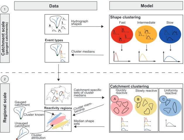
Paper V deals with Questions 2 and 3. It proposes a clustering approach based on functional
data to identify sets of representative hydrograph shapes within a catchment and regions of similar flood reactivity on a regional scale. The delineation of such reactivity regions is a first step towards a regional SDH construction approach that allows for the construction of event-type specific SDHs in ungauged catchments.
Paper VI deals with Question 3. It proposes a method for the regionalization of event-type
specific SDH sets to ungauged catchments. It uses the idea of the delineation of flood reactivity regions proposed in Paper V in a regional index flood approach which is extended to a regional SDH construction approach.
The six papers form a logical sequence and are closely linked. Bivariate return periods as discussed in Paper I are fundamental for the construction of SDHs which is discussed in Paper II for both a catchment-specific and a flood-type specific framework. Paper III focuses on the regionalization of catchment-specific SDHs. In contrast, Papers V and VI deal with the regionalization of event-type specific SDHs. In a first step, Paper V deals with the delineation of regions with similar representative hydrograph sets and therefore similar reactivity. In a second step, Paper VI uses these regions in a regional SDH construction approach which is based on a bivariate index flood approach. Paper IV looks at the uncertainty of SDHs focusing on catchment-specific SDHs. Uncertainty due to process variability is addressed in papers V and VI by the construction of event-type specific SDHs. All six papers focus on a return period of T =100 years since this return period is often used as a reference in national guidelines to define protection goals for settlements in Switzerland (Camezind-Wildi, 2005). The methods proposed or applied, however, are applicable for any return period of interest considering the limits posed by the limited data availability (Deutsche Vereinigung für Wasserwirtschaft Abwasser und Abfall, 2012).
C
H
A
P
T
E
R
3
M
ATERIAL AND
M
ETHODS
T
his chapter first introduces the dataset used to perform the analyses conducted within this thesis. An overview is then given on the methods used to construct SDHs in gauged catchments, to regionalize SDHs to ungauged catchments, and to assess SDH uncertainty.3.1 Study catchments
The analyses conducted in the context of this thesis rely on observed runoff time series and catchment characteristics of 163 study catchments in Switzerland.
3.1.1 Runoff observations
The dataset comprises catchments (Figure 3.1) with a wide range of catchment characteristics and flood behaviors. The selected catchments have hourly flow series of at least 20 years in duration ranging up to 53 years. The catchments’ runoff is neither altered by regulated lakes upstream or inland canals nor by urbanized areas. The catchments are small to medium-size (6 to 1800 km2), situated at mean elevations between 400 and 2600 m.a.s.l., and have either no or only a few areas with glaciers. Papers III to VI used the whole set of catchments while Papers I and II used only a subset of catchments.
The basis for each analysis was samples of flood events extracted from the runoff time series of the study catchments. Flood events were sampled using a peak-over-threshold approach based on the procedure proposed by Lang et al. (1999). The threshold for the peak discharges was chosen iteratively to fulfill a target condition of four events per year on average which is a trade-off between maximizing the information content in the sample and keeping the assumption of independence between events. For each of these events, sampled according to the flood peaks,
3.2. BIVARIATE RETURN PERIODS
allowing the assignment of an ungauged catchment to one of the reactivity regions. This subset consisted of catchment area, network density, Y-coordinate, soil topographic index, percentage area of karstic rocks, sunshine duration, and vapor pressure.
3.2 Bivariate return periods
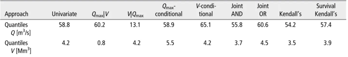
The return period contains information about the non-exceedance probability of an event which has traditionally been described in terms of its peak discharge in a univariate frequency analysis. A bivariate analysis, however, is more appropriate if two dependent variables, such as peak discharge and hydrograph volume, play a significant role in the ruling behavior of a flood (Salvadori et al., 2014). While the return period is uniquely defined in a univariate setting, this is not the case in the bivariate setting (Gräler et al., 2013; Salvadori et al., 2011; Yue and Rasmussen, 2002). The return period used to describe bivariate events can be determined by three types of approaches: 1) use of the conditional probability, 2) use of the joint probability, and 3) use of the Kendall’s distribution or survival function. The choice of one of these approaches depends on the problem at hand (Serinaldi, 2015). The conditional probability is used if one variable (often peak discharge) is considered to be more important than the other variable of interest (e.g. hydrograph volume). On the contrary, the joint probability is used if both variables are considered to be equally important for the design problem at hand. All these bivariate approaches have in common that, on the contrary to the univariate approach, there is no unique solution for design variables with a specific return period T. Instead, various combinations of peak discharges and hydrograph volumes share the same return period and lie on an isoline. For practical reasons, one event on the isoline is often chosen and called the design event. Usually, this is the most-likely design realization on the isoline, i.e., the point with the largest probability density along the isoline (Salvadori et al., 2011). A more detailed description of possible return period definitions and of approaches to choose one design variable pair is provided in Paper I.
This thesis considers both peak discharge and hydrograph volume to be equally important for the design problem at hand and therefore focuses on the joint OR return period which uses the probability that either peak discharge or hydrograph volume (or both) exceeds a given threshold. It is defined as: (3.1) T(x, y) = µt Pr[X > x ∨ Y > y]= µt 1 − FX(x) − FY(y) + FX Y(x, y) = µt 1 − C(u, v),
where X and Y are random variables, C is a copula, x and y are given thresholds, µt is the inter-arrival time between two successive events u = FX(x) and v = FY(y), and FX, FY, and FX Y are the marginal and joint distribution functions of the random variables respectively (Salvadori, 2004; Salvadori and De Michele, 2004). Throughout this thesis, one single design variable pair is obtained from the isoline by selecting the point with the largest joint probability density as follows:
CHAPTER 3. MATERIAL AND METHODS
(3.2) (u, v) = argmax
C(u,v)=t
fX Y©F−1X (u), FY−1(v)ª.
3.2.1 Marginal distributions
The marginal distributions of peak discharges and hydrograph volumes are linked to the flood sampling strategy. The flood samples used in this thesis were obtained by a peak-over-threshold (POT) approach which samples those events with a peak discharge higher than a predefined threshold (Lang et al., 1999). POT samples, according to extreme value theory (Coles, 2001), follow a generalized Pareto distribution (GPD) which is defined as:
(3.3) FX(x) = 1 −n1+ξ
³x −µ σ
´o−1ξ
ξ6=0,
with a location parameterµin R, a scale parameterσ>0, and a shape parameterξin R. The corresponding hydrograph volumes were defined over a time window of 72 hours starting 24 hours before peak discharge. Their marginal distribution can be described by a generalized extreme value (GEV) distribution as:
(3.4) FY(y) = exp · −n1+ξ³y −µ σ ´o−1ξ¸ ξ6=0,
with domain 1+ξ³y−µσ ´>0 forξ6=0 and with a location parameterµin R, a scale parameterσ>0, and a shape parameterξin R.
POT series have the advantage of including all relevant flood events, which is not guaranteed when working with annual maxima series (Lang et al., 1999). However, the independence of the events needs to be ensured. In this thesis, a minimum time difference of 72 hours between two successive events was prescribed to ensure their independence.
3.2.2 Copulas
The joint distribution of peak discharges and hydrograph volumes needs to reflect their depen-dence. Contrary to classical bivariate distributions, copula models allow the modeling of two dependent variables with different marginal distributions (Genest and Favre, 2007). The copula approach has its origin in the representation theorem of Sklar (1959) which states that the joint cumulative distribution function FX Y(x, y) of any pair of continuous random variables (X ,Y ) can be written as:
(3.5) FX Y(x, y) = C©FX(x), FY(y)ª, x, y ∈ R,
where FX(x) and FY(y) are the marginal distributions and C : [0,1]2 is the copula. C is unique if the marginals are continuous. One of the main advantages of the copula approach is that the
3.3. SDH CONSTRUCTION
selection of an appropriate copula for modeling the dependence between X and Y can proceed independently from the choice of their marginal distributions (Genest and Favre, 2007).
The copula models considered in the context of this thesis were five copulas of the Archimedean copula family (Ali-Mikhail-Haq (AMH), Clayton, Frank, Gumbel (also belonging to the extreme-value copula family), and Joe), two copula models of the elliptical copula family (Normal and Student-t copula), and the independence copula (Joe, 2014). They were fitted using maximum pseudo-likelihood estimation to the pseudo-observations, which are deduced from the ranks of the observations. After the fitting, the copulas were tested using both graphical approaches and a goodness-of-fit test based on the Cramér-von-Mises statistic (Genest and Favre, 2007). A p-value for the Cramér-von-Mises statistic of each copula was estimated using a statistical bootstrap procedure (Genest et al., 2009). The Joe copula was found to be the most suitable model to represent the dependence between peak discharges and hydrograph volumes within a single catchment. It is expressed as:
(3.6) C(u, v) = 1 − £(1 − u)θ+(1 − v)θ−(1 − u)θ(1 − v)θ¤1θ ,
whereθis the copula parameter, u = FX(x) and v = FY(y) are uniformly distributed between 0 and 1, and their dependence is modeled by the copula C.
The Joe copula is very flexible and can represent the bivariate distributions of the flood samples in most catchments even when they are divided by flood types. In addition, it is able to model the upper tail dependence (Heffernan, 2000) present in the data as described by the upper tail dependence coefficient (Poulin et al., 2007).
In a regional setting (see Paper VI), when pooling data from several catchments, the Student-t copula was found to be more suitable to model the dependence in the data than the Joe copula. It showed the lowest Cramér-von-Mises test statistic among all the copulas tested and similar to the Joe copula was able to model the tail dependence in the data (Frahm et al., 2003).
3.3 SDH construction
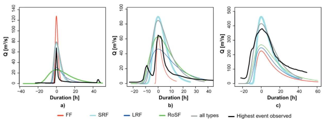
Catchment-specific and flood-type specific SDHs are constructed using observed hourly runoff time series. The construction approach models the magnitude of the design flood using a bivariate frequency analysis and the shape of the hydrograph via a probability density function. The method can be either applied to construct a catchment-specific SDH without any differentiation between flood types or to construct flood-type specific SDHs. Flood-type specific SDHs can be constructed for flash floods (FF), short-rain floods (SRF), long-rain floods (LRF), or rain-on-snow floods (RoSF), but not for snowmelt floods (SMF) and glaciermelt floods (GMF). The eleven steps involved in the procedure are illustrated in Figure 3.2, listed in the paragraphs below, and described in detail in Paper II. A more detailed description of the catchment-specific construction procedure can be found in Brunner et al. (2016).
CHAPTER 3. MATERIAL AND METHODS FF SRF LRF RoSF GMF SMF
1) Flood sampling 2) Classification Q t 1 1 3) Baseflow separation 4) Normali-zation 5) Identification of representative normalized hydrograph 6) Fitting of probability density function 11) SDH construction
=
+
=
Q V Q Q Q Q Q t t t t t 7) Dependence modelling 8) Choice of a return period definitionT
=
9) Estimation of and Q t 10) Computa -tion of Q t pFigure 3.2: Method for the construction of synthetic design hydrographs (SDHs). The method can either be applied to all types of flood events identified in a catchment or it can be used to construct flood-type specific SDHs. The approach consists of eleven steps. The SDH (QT(t)) can be expressed by a probability
3.3. SDH CONSTRUCTION
1. Flood sampling: Flood sampling using a POT approach which samples four events per year on average (see also Section 3.2.1).
2. Classification: Attribution of each flood event to one out of six flood types according to its triggering mechanism using a flood classification scheme adjusted from Merz and Blöschl (2003) and Sikorska et al. (2015). The flood types comprise flash floods (FFs) caused by short but very intense rainfall, short-rain floods (SRFs) caused by rainfall lasting no longer than one day, long-rain floods (LRFs) caused by rainfall lasting several days, rain-on-snow floods (RoSFs) triggered by rainfall falling on snow, snowmelt floods (SMFs) caused by a temperature-induced melting of snow cover, and glaciermelt floods (GMFs) caused by a temperature-induced melting of glacier cover. The classification scheme assigns a flood event to one of the flood types based on eight indices: timing of the flood, precipitation amount, precipitation duration, precipitation intensity, glacier cover, snow cover, snowmelt, and catchment wetness (Sikorska et al., 2015). The focus of this thesis was on FFs, SRFs, LRFs, and RoSFs because the number of SMFs and GMFs was very low and the latter are less relevant for flood management because of their rather low peak discharges. The classification step can be skipped if catchment-specific SDHs instead of flood-type specific SDHs are of interest.
3. Baseflow separation: Separation of baseflow from the quick flow component of the event hydrographs to enable their statistical analysis (Yue et al., 2002). A recursive digital filter was applied (Eckhardt, 2005) to separate quick flow from baseflow whose two parameters were estimated for each catchment individually.
4. Normalization: Normalization of the quick flow component of the hydrographs by dividing the base width by its duration D and the ordinate by the mean runoff (V /D).
5. Identification of representative normalized hydrograph: Identification of a repre-sentative normalized hydrograph (RNH) as the median normalized hydrograph of the event set under consideration (whole dataset or flood-type specific datasets). The median hydrograph was defined using a notion of depth for functional data (Ramsay and Silverman, 2002). The concept of data depth can be used to define the centrality of a hydrograph within a group of hydrographs and to define their ranks. This enables the computation of robust estimators of the median among curves. Among different definitions of data depth, the h-mode depth (Cuevas et al., 2007) was chosen and used to determine the median hydrograph within a set of hydrographs.
6. Fitting of probability density function: Fitting of a probability density function (PDF) to the RNH. PDFs can take various shapes and the area under their curves is equal to one as is the one under the RNH. The parameters of the PDF can be derived via an analytical expression using the time to peak, peak discharge, and the time base of the
CHAPTER 3. MATERIAL AND METHODS
RNH (Nadarajah, 2007; Rai et al., 2009). A comparison of eight commonly used PDFs (beta, gamma, Fréchet, inverse gamma, logistic, lognormal, normal, and Weibull) has shown that the lognormal is the most suitable PDF to model the shape of the hydrographs. The dimensionless shape of the design hydrograph can be upscaled to an SDH using design variable quantiles.
7. Dependence modeling: Estimation of the parameters of the marginal distributions of peak discharges (GPD: Equation 3.3) and hydrograph volumes (GEV: Equation 3.4). Estimation of the parameter of the Joe copula. Modeling of the dependence between peak discharges and hydrograph volumes using the Joe copula model (Equation 3.6).
8. Choice of return period definition: Choice of a return period definition according to the problem at hand (Serinaldi, 2015) (see Section 3.2). In this thesis the joint OR return period was used assuming that peak discharge and hydrograph volume were equally important. 9. Estimation of QTand VT: Estimation of the design variable quantiles peak discharge (QT)
and hydrograph volume (VT) with the defined return period. The quantiles are obtained by inverting their marginal distributions FX and FY:
(3.7) QT=F−1X (u)
and
(3.8) VT=FY−1(v).
10. Computation of DT: Computation of the design duration (DT) from the design estimates of QTand VTas DT=f(tp)VT/QT, where f (tp) is the lognormal density at the time to peak tp.
11. SDH construction: Construction of the SDH using the lognormal distribution fitted to the RNH and the estimates for VT and DT using:
(3.9) QT(t) = f (t)VT/DT+B,
where B is the baseflow to be added to the direct flow component. The baseflow is estimated by a mean event baseflow index computed for each catchment.
The construction of an SDH requires knowledge of ten parameters: event baseflow index, location and scale parameter of the lognormal distribution, a location, scale, and shape parameter for the two marginal distributions of the peak discharges and the hydrograph volumes as well as the parameterθof the Joe copula. A more detailed description of the statistics of these parameters, their correlation, and distributions is provided in Paper III. The approach described above can be applied to the whole sample of flood events in a catchment or to a subsample of flood events representing a particular flood type. The event-type specific construction is an ensemble based approach that represents the flood behavior of a catchment described by different process types.
3.4. SDH REGIONALIZATION
3.4 SDH regionalization
Design flood estimates are not only required in catchments where runoff observations are available but also in ungauged catchments where such observations are missing. Therefore, suitable approaches were sought that allowed for the transfer of SDHs to ungauged catchments. In a first step, catchment-specific SDHs were regionalized to ungauged catchments. In a second step, event-type specific SDH sets were transferred to ungauged catchments. The approaches used for the regionalization of catchment-specific SDHs is summarized in this paragraph and described in more detail in Paper III. The regionalization of event-type specific SDHs is addressed in Section 3.7 and described in detail in Paper VI. Various regionalization approaches can be used to regionalize the ten parameters of a catchment-specific SDH (see Section 3.3) to ungauged catchments. In this thesis, approaches from three categories were tested for their suitability to regionalize SDH parameters: 1) methods based on the relation between catchment characteristics and model parameters, 2) approaches based on spatial proximity, and 3) methods based on homogeneous regions (Figure 3.3). Approaches belonging to Category 1 comprise linear and nonlinear regression models. Methods belonging to Category 2 comprise spatial methods such as k-nearest neighbors, inverse distance weighting, and several kriging approaches. Category 3 delineates homogeneous regions, assigns an ungauged catchment to one of the regions based on its catchment characteristics, and estimates its SDH parameters based on the SDH parameters of the catchments belonging to the corresponding region. Since nonlinear regression models have not been frequently used in hydrological applications, they are shortly described in the next paragraph. More information on the other regionalization methods can be found in Paper III and the references cited therein.
C H A P T E R 3 . M A T E R IA L A N D M E T H O D S Nonlinear Trees Bagging Random forest Boos!ng Global Regression Linear Full Subset selec!on Dimension reduc!on Shrinkage Forward Backward Principal components Par!al-least-squares Ridge Lasso Spa!al Kriging Ordinary Trans-Gaussian Universal Topological Benchmark Catchment size Catchment eleva!on Individual parameters Mul!variate
Transfer most similar catchment
Forma!on fixed groups Mean Mean Forma!on homogeneous regions Transfer parameterset Pooling data
Most similar catchment Mean similar catchments Median similar catchments
Parameter es!ma!on Mean
Whole parameterset
K-means clustering Mean
K-nearest neighbors Mean parameter
IBF
Regional
Regional
Inverse distance weigh!ng
Figure 3.3: Methods tested to regionalize the ten parameters of a catchment-specific SDH on a global or regional scale. The methods were grouped into
3.5. SDH UNCERTAINTY
3.4.1 Nonlinear regression models
In the context of this thesis, the term nonlinear regression models is used for tree-based regression methods (Strobl et al., 2009). Tree-based methods split the space of catchment characteristics used as explanatory variables into a number of regions containing catchments with similar SDH parameters. The set of splitting rules used to divide the space of explanatory variables can be summarized as a tree (Hastie et al., 2008). Tree models are usually applied as an ensemble to avoid overfitting and improve prediction accuracy. Such ensemble methods comprise bagging, random forest, and boosting (James et al., 2013). Bagging uses bootstrap techniques to draw random samples from the catchment set, builds regression trees for each of these samples, uses each of the trees to make predictions for the SDH parameter under consideration, and averages these predictions. Random forest is similar to bagging but considers only a subset of catchment characteristics to be used in each split of the tree model to decorrelate the individual models (Breiman, 2001). Boosted regression trees (Freund and Schapire, 1996; Friedman, 2001, 2002) work similarly but fit the regression trees iteratively focusing on catchments modeled poorly by the existing collection of trees (Hofner et al., 2014).
3.4.2 Model validation
The predictive performance of the regionalization methods tested was compared to a benchmark model represented by the arithmetic mean (Parajka et al., 2005; Razavi and Coulibaly, 2013) over the SDH parameters of the 163 study catchments (Section 3.1). The validation of the methods was done using 10-fold cross validation by dividing the dataset into 10 parts of equal size, estimating the SDH parameters using 9 out of these folds, and predicting the SDH parameters and constructing the SDHs for the catchments in the remaining fold (James et al., 2013). The validation was on the one hand performed for the individual SDH parameters and on the other hand for the constructed SDHs in terms of their relative error. In the first case, each of the regionalized SDH parameters was compared to the corresponding SDH parameter estimated using runoff observations. In the second case, the hydrograph resulting from the regionalized SDH parameters was compared to the SDH estimated based on runoff observations. The relative error of the regionalized SDH compared to the estimated SDH was computed for four hydrograph characteristics (see Figure 3.4) including peak discharge (Qp), hydrograph volume (V ), time to peak (tp), and half-recession time (the time from peak to where the recession reaches half of the peak discharge) (tp05).
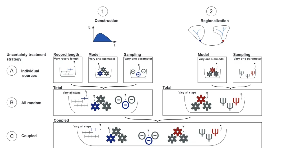
3.5 SDH uncertainty
The uncertainty of constructed and regionalized SDHs was quantified in an uncertainty assess-ment framework. This framework is shortly outlined here and a detailed description is given in Paper IV. The framework consists of three levels of complexity (Figure 3.5). On a first level (A), the
CHAPTER 3. MATERIAL AND METHODS
Q
pV
t
pt
p050.5 Q
pt
Q
Figure 3.4: Illustration of the hydrograph characteristics used for the validation of the regionalization methods: peak discharge (Qp), hydrograph volume (V ), time to peak (tp), and half-recession time (tp05).
effect of different uncertainty sources comprising record length, model, and sampling uncertainty was assessed. This allowed for the identification of important uncertainty sources. On a second level (B), the total uncertainty of constructed SDHs and regionalized SDHs was assessed without considering their dependence. On a third level (C), the uncertainty of the constructed SDHs was propagated through regionalization to assess the coupled uncertainty of SDH construction and regionalization. The uncertainty assessment was based on bootstrap simulations which involve the random sampling of data points, with replacement, from the original sample (Efron and Tibshirani, 1993). The bootstrapping was done on various model configurations (model choices and parameters) to construct a set of SDHs. The resulting set of SDHs was compared to an SDH obtained as the best estimate under the standard configuration (see Section 3.3).
3.5.1 Level A: Uncertainty due to individual sources
Level A distinguished between three categories of uncertainty: 1) uncertainty due to limited record length, 2) model uncertainty resulting from the choice of one model over another feasible model, and 3) sampling uncertainty resulting from estimating the model parameters based on an available flood sample that only approximates the characteristics of the underlying population. The impact of the individual uncertainty sources on the estimated SDH was assessed by focusing on one uncertainty source at the time. This was done by constructing various SDHs using a slight modification of the standard model configuration (see Section 3.3) either varying one model choice or considering the uncertainty of one parameter at the time. The set of SDHs obtained by these simulations gave an idea of the variability introduced by each source of uncertainty. The uncertainty sources considered comprised record length, choice of the flood sampling strategy, parameter uncertainty in baseflow separation, choice of the depth function used to identify the median normalized hydrograph (RNH), choice of the PDF used to model the hydrograph shape, choice of the marginal distributions to model peak discharges and hydrograph volumes, uncertainty in the estimation of the parameters of the marginal distributions, choice of the copula
3 .5 . S D H U N C E R T A IN T Y
Record length Model Sampling Model Sampling
Total Total
Coupled
Construction Regionalization
Vary all steps
Individual sources
A
B
C
All random Coupled Uncertainty treatment strategy1
2
Q tΘ
Θ
Θ
Vary one submodel
Θ
Θ
Θ
Vary one parameter
Vary record length Vary one submodel
ψ
ψ
Vary one parameter
ψ
Vary all steps
ψ
ψ
ψ
Vary all steps
Θ
Θ
Θ
ψ
ψ
ψ
Figure 3.5: Uncertainty assessment framework with three levels of complexity: A) Uncertainty introduced by individual sources, specifically, record length, model choices, and sampling uncertainty; B) Total uncertainty of the constructed SDH and total uncertainty of the regionalized SDH resulting from the sources described in A; C) Coupled uncertainty of the SDH when construction uncertainty (steps 1A-1B) is propagated through regionalization (steps 2A-2B) onto the final regionalized SDH.
CHAPTER 3. MATERIAL AND METHODS
family to model the dependence between peak discharges and hydrograph volumes, uncertainty in the estimation of the parameter of the copula, choice of a design variable pair on the isoline, baseflow addition, and model and parameter uncertainty associated with regionalization.
3.5.2 Level B: Total uncertainty
The total uncertainty of SDH construction and SDH regionalization was assessed independently. The total uncertainty related to SDH construction was assessed by a bootstrap experiment. Contrary to Level A, neither model choices nor parameters were fixed. At each step of the construction procedure, one option was randomly sampled from the model and/or parameter space to jointly consider all uncertainty sources involved in SDH construction. The total uncertainty due to SDH regionalization was also assessed by bootstrap simulations. In each run, a regionalization model was sampled from the model space and fitted for each SDH parameter using data from a resampled catchment dataset. The fitted models were then used to predict the SDH parameters of the catchments in the original catchment set.
3.5.3 Level C: Coupled uncertainty
The coupled uncertainty jointly considered construction and regionalization uncertainty. There-fore, the uncertainty of the constructed SDHs was propagated through the regionalization process. Catchment-specific distributions of the ten SDH parameters were defined on Level B by construct-ing 1000 SDHs under various bootstrapped model configurations. This construction uncertainty was then propagated through regionalization by fitting a randomly sampled regionalization model to a resampled catchment set. While the ten SDH parameters were fixed for each catchment in the total regionalization uncertainty, the coupled uncertainty sampled the ten SDH parameters for each of the resampled catchments from their catchment-specific empirical distributions.
3.5.4 Uncertainty quantification
Each level of the uncertainty analysis provided a set of SDHs obtained by varying one or several model choices and/or considering sampling uncertainty. These sets were compared to the best estimate SDH obtained by the standard configuration (see Section 3.3) without considering uncertainty. The absolute relative error of each simulated SDH compared to the best estimate SDH was computed and summarized over all catchments as the median absolute relative error (EMAR). The EMAR was computed for the four hydrograph characteristics Qp, V , tp, and tp05, which were already used for the validation of the regionalization approaches in Paper III (Figure 3.4).


![Table 1: List of stations used in this thesis. The station name is provided together with a catchment ID, catchment area [km 2 ], elevation [m.a.s.l.] (ELEV), mean elevation [m.a.s.l.] (MELEV), degree of glaciation [%] (DG), record length [a] (RL), and the](https://thumb-eu.123doks.com/thumbv2/123doknet/14712981.568068/80.892.109.765.474.1159/stations-station-provided-catchment-catchment-elevation-elevation-glaciation.webp)
![TABLE 1 | Possible Joint Events Using the OR “_” and the AND “^” Operators [Correction added on 21 September 2016, after first online publication: instances of underscore “_” have been changed to “_” as the correct symbol for "OR".]](https://thumb-eu.123doks.com/thumbv2/123doknet/14712981.568068/91.892.169.739.148.329/possible-events-operators-correction-september-publication-instances-underscore.webp)