Excavations at the Nubian royal town of
Kerma:
1975-91
CHARLES BONNET*
Kerma is an ancient city on the Nile in Middle Nubia, long known and the subject of renewed recent exploration. Its position, at the southern limit of Egyptian control, sets it strategically on the routes to the African interior. Its environment in the arid desert
results in remarkable preservation
of
organic remains.The discovery of Kerma
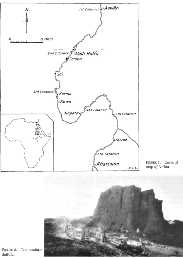
The first European travellers who made their way beyond the Nile’s 3rd cataract at the begin- ning of the 19th century found themselves in a wide, fertile plain, inhabited for thousands of years past. The meanders of the Nile and a wadi favoured the exploitation of these lands. Above the rapids, near the village of Kerma, two enigmatic, massive constructions attracted notice: the native inhabitants called them deffu-
fas, from a Nubian term indicating any large mud-brick structure rising out of the surround- ing plain (Reisner 1923: I: 14-18; Bonnet et al. 1990: 25-7) (FIGURE 1).
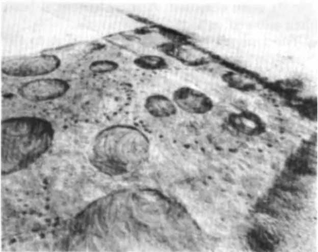
It was not until 1913-16 that archaeological work by G.A. Reisner satisfied some of the curiosity of men of science. According to this famous American Egyptologist, Kerma was an Egyptian trading post set in Sudanese territory, and the western deffufa the remains of a for- tified residence occupied by foreign overseers (Reisner 1923: I: 37-40; V: 554-9). The second deffufa, sited in the cemetery, had from the outset (Reisner 1923: 111: 123, 132-4) been identified as the funerary chapel of an enor- mous tumulus, in which had been buried, not far from the principal subject, several hundred human sacrifices. Fine objects, some imported, confirmed a date from the end of the Old to the Middle Egyptian Kingdom.
Reisner’s ideas were rapidly discussed, and many recognized in this site the remains of a native population with customs distinct from
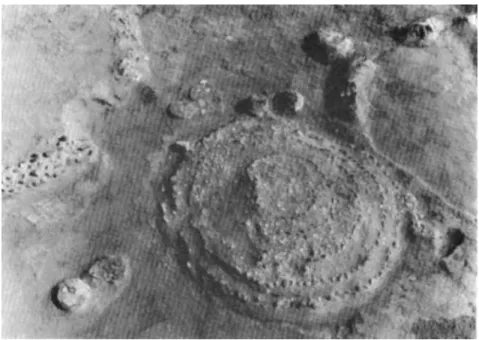
those of their northern neighbours (Junker 1921; 1932). The western deffufa continued to give rise to diverse interpretations; a recent sug- gestion has it as a watch-tower to oversee the traffic along the Nile (FIGURE 2) (Adams 1977b).
Recent research in Kerma and its region
In the 1970s, research in the Kerma necropolis of Sai, about 100 km to the north, allowed the French archaeologist B. Gratien to distinguish four phases in the development of the Kerma civilization, from 2400 to 1500 BC, based on the evolution of pottery, funerary ritual, and tomb morphology (Gratien 1978: 133-223,320; 1986) (TABLE 1). Further studies contributed knowledge of the contemporary ‘Group C’ cul- ture in Lower Nubia, whose territory formed an intermediate zone between Egypt and Kerma (Bietak 1968). It was mainly during the Nubia campaign, before the flooding above the Aswan dam, that this region became an excavation area of prime importance from which numerous
name date (BC) Pre-Kerma Early Kerma Middle Kerma Classic Kerma Final Kerma 3500-2 500 2 5 00-2 05 0 2050-1 750 1 7 5 0-1 5 80 1580-1500 TABLE 1.
Kerma culture. The four chronological periods of the * Mission Archeologique de I’Universite de Geneve au Soudan, 17 chemin du Bornalct. 1242 Satigny, Switzerland.
CHARLES BONNET
u Khartoum
-H.A.S-
FIGURE 1. General map of Nubia.
FICURS 2. The western deffufa.
EXCAVATIONS AT THE NUBIAN ROYAL TOWN OF KERMA: 1975-91 61 3 results were obtained. A solid historical basis
then allowed us to turn southwards.
The University of Geneva’s Mission to the Sudan worked on the Tab0 site, where remains from the 25th Dynasty (around 800 Bc) as well as from the Napata, Meroitic and Christian eras had been discovered (Maystre et al. 1986). In 1976, the Mission moved across to Kerma to research the origins of the first cultures from north Sudan. This site offered an extraordinary chance for investigation, as research could be carried out simultaneously in the ancient town and in the associated cemetery, where prelim- inary survey revealed at least 30,000 burials.
For 15 years, campaigns were divided between the long-term research programme for
the ancient town and that for the cemetery. Various rescue digs also took place in other areas threatened with destruction. The remains discovered complete our information for some very ancient periods and also for some later ones. The taking into cultivation of what has up to now been desert makes it essential to survey the region to establish the sensitive areas.
A great number of prehistoric sites have been recorded, often far removed from the present course of the Nile. It is probable that the arms of the river used to cover a much wider area, which climatic change has made progressively smaller, then suppressed the savannahs and wide strips of fertile ground formerly flooded by the river. Since the end of the Neolithic, warm- ing has been more and more marked.
To appreciate the wealth of this prehistoric heritage better, the Mission has begun a fruitful collaboration with the members of the French section of the Sudanese Direction of Antiqui- ties, and in particular with its director. Jacques Reinold, a prehistorian. Excavatioiis and sur-
veys currently in progress have allowed the Franco-Sudanese Mission to prove the excep- tional development of Neolithic peoples. A protection policy has also been established, and we hope that the large cemeteries will be able to be preserved.
The pre-Kerma period
Four km east of the present Nile, on the site where the necropolis of Kerma was later to
develop, an establishment from the end of the 4th millennium BC was discovered that extends
across the whole of the central part of the cemetery. Work on it will require several years.
-
The remains are in the form of pits dug into the alluvial soil and post-holes giving the plans of
huts, usually circular in shape. In the granaries
or silos, with walls sometimes reddened by fire, were deposited jars or smaller receptacles, and grain. The pottery, different from that of
Ancient Kerma, is closer in type to - while still perceptibly different from - that of Group A, with which it is no doubt contemporaneous. By contrast with what we find in Lower Nubia, not a single sherd of imported Egyptian ware was found in our site, and so we prefer the term ‘pre-Kerma’ for this Middle Nubian culture (FIGURES 3, 4).
The granaries were grouped in a central area; the area so far excavated is small, and so it would be premature to draw conclusions. How- ever, it can be seen that in the zones with a heavy concentration of grain-pits, post-holes are practically absent. By contrast, at the edges, the post-hole circles often intersect one another several times (FIGURE 5).
At the current stage of research, we may date this establishment to around 3000 BC. It was probably occupied until the settlement moved further west, closer to the river. The necropolis bears witness to a continuity of occupation, perhaps with an earlier cemetery still to be discovered.
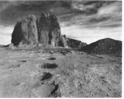
The western deffufa: a temple and its quarter
It is probable that the ancient town developed gradually around an early sanctuary located beneath the western deffufa. We have in fact established that the deffufa in its present form is the culmination of a long architectural develop-
FIGURE 4. Part of the plan of the pre-Kerma site.
FIGURE 5. Middle Kerma.
Circular huts and the later tombs of the
ment, since at least 12 phases have been distin- guished in the masonry (FIGURE 6). Below the massive structure, numerous occupation levels indicate yet earlier phases. We have also estab- lished that, for a fairly long period, the mon- ument had a kind of bastion or solid apse on its north side, a feature also found at the northern end of a large chapel located in the cemetery. Comparative study of the different funerary buildings rapidly convinced us of the religious function of the western deffufa, which was doubtless the main temple of the town. The extent of the religious quarter round about suggests the existence of a cult ‘institution’, perhaps analogous to those in Egyptian tem- ples. Isolated from the rest of the agglomeration by walls-more than 5 m high, this quarter comprised several chapels, a large habitation and workshops such as that of the bronze- workers, whose furnaces imply relatively sophisticated technical knowledge (FIGURE 7).
The southwestern hut
Not far from the religious quarter, towards the southwest, was another exceptional structure, a second focal point of the town. This very large hut must have been at least 10 m high. It
remained in use for several centuries, and was not finally abandoned until the Classic Kerma phase. From the outset, the master-builder opted for a rather complicated mixed construc- tion, using both wood and mud-brick. Three rows of sturdy wooden supports and a rounded wall in mud-brick supported the roof, which
EXCAVATIONS AT THE NUBIAN ROYAL TOWN OF KERMA: 1975-91
FIGURE 7. General view of the religious quarter, surrounded by the ancient town.
615 FIGURE 6. Kerma. The deffufa, a temple in the middle of the town.
was probably conical. A sort of portico is inferred from innumerable post-holes on the periphery of the structure. Inside, a brick wall defined a large room, about 12 m square, while two adjoining rooms and passages facilitated service.
This large building was in its turn isolated from the neighbouring houses by a large enclos- ure which, in its final phase, was formed ‘by a thick wall built in fired brick. This enclosure, round three sides, was closed by a palisade of large posts in front of the southern gates. For the period, no parallel is known for this large building, either in Egypt or in central Africa. However, it illustrates an architectural type later widespread over the continent, as witness the reception rooms of the sultans of Darfur or the audience chambers of the kings of southern Sudan (FIGURE 8).
The town
In order to gain a rapid overview of the town, large surface areas were cleared and several quarters have already been studied. Domestic architecture displays a great diversity of influ- ences enriching the local Nubian tradition. Although the custom of building in wood and other perishable materials persists, brick archi- tecture seems to appear very early. Initially, houses built of mud-brick comprise a single,
FIGURE 8. The large hut.
small room (3 x 4 m). They gradually become more complex, although the number of rooms is never more than four. A layout of two adjoining rooms is the most common; another with the building in two parts on either side of an interior courtyard is also well represented. Even today this is the most frequently adopted solu- tion in the area. On the southern side extends the large exterior courtyard, comprising kit- chens, pits for firing pottery, enclosures for small livestock, and silos or food-stores. We cannot rule out the presence of trees and gar- dens. The town layout was organized without any preconceived plan, and the course and width of the streets are a function of land occupation. Cul-de-sac streets often lead to a small enclosed square serving three or four houses.
Thus the general plan of the town of Kerma does not resemble that of Egyptian forts or the famous workers’ villages of the Middle and New Kingdoms. Rather it evokes a large agricultural settlement, shaped to accommodate changes in family, or the fortunes of the landowners. In general, domestic architecture remains modest; it does not reveal the strong hierarchy of the cemetery, where the proportions and richness of grave furnishings demonstrate the import- ance of the buried persoii (FIGURE 9).
Religious buildings in the town
The discovery of several private places of wor- ship demonstrates that the population was very religious, as is shown also by several Egyptian texts. It is clear that domestic altars were set up in certain rooms, but places specifically reserved for worship have also been found, notably in house no. 100 in the northwestern quarter. Although its plan is traditional - two long sections of building separated by an inner courtyard - the aImost triangular shape of the external courtyard is not usual. The thick wall which delimits it follows an irregular line, even sinuous in places, and we have been able to establish that certain sections were rebuilt several times. In this courtyard were kitchens, protected by a small shelter, and potters’ kilns. On the east side, a secondary habitation was linked to the principal unit by a covered pas- sage. In the northwest corner, backing on to the main gate, an apsidal space opened on to the courtyard. Its entrance was flanked by two pillars, between which post-holes indicated a
EXCAVATIONS A T THE NUBIAN ROYAL TOWN OF KERMA: 1975-91 61 7
flimsier closure. The roof was supported by a central beam. As in several chapels of the religious quarter or the cemetery, the floor of the apse was completely covered with a wash of red ochre. Use of ochre for religious or magic purposes is well attested at Kerma, as well as in Egypt where this colour was, for example, used to combat demons. Numerous traces of pegs 5 cm in diameter, noted on the floor, remain difficult to interpret. Several superimposed hearths were found, but it is unlikely that they were used to heat food as the earth is little reddened and charcoal abundant.
Although situated a little apart, this apse is closely associated with the life of the household across the courtyard. It evokes the often light- weight structures (el’messiid) in which today a part of the family unit will meet to discuss day-to-day problems arid to pray.
In another house (no. 88), the place of wor- ship associated with the living area was built in imitation of the chapels of the religious quarter, with a square plan, one or several axial sup- ports, and a levelled and red-ochre-washed
floor. The walls are thick, and we may suppose that the building was higher than the neigh- bouring houses.
Fortifications
The town was defended by a very elaborate system of fortification: wide, massive walls protected by projecting rectangular towers and
FIGURE 9. General view of the northern quarter of the ancient town. surrounded by dry ditches to prevent under- mining (FIGURE 10). It was the excavation of these ditches, up to 5 m deep, that provided the mud for ramparts, built in places on a thick foundation of stone from the quarries of the 3rd cataract at Tumbus, 30 km away. During the Classic Kerma period, fired brick was widely used to build stronger wall facings.
The gates and fortifications of the town did not withstand the attacks of the pharaohs of the 18th Dynasty (after 1580 BC) and erosion by the
wind. In fact, it is the dry ditches which reveal in negative the general outline of the final stages of the ramparts. In this way we have located the four principal means of access, disposed at the cardinal compass points, and indicated by a wide clear space, devoid of structures, penetrat- ing the interior of the agglomeration. The pas- sage leading to the gate was flanked by walls which facilitated its surveillance. The space either side of the passage was blocked by a series of palisades occupying the whole area up to the base of the fortification. Barriers of logs to prevent mining ran along the external ditches.
The standing of Kerma
The urban organization, as well as the size of
some tombs, leads us to consider Kerma as the capital of the kingdom. However, it is probable that the ancient town made up only a part of the economic and political centre. Although a palace has been discovered within the city
618 CHARLES BONNET
FIGURE 10. Part of the town’s ditch defences. during our latest season (1991-2), it seems quite
certain that there was another palace outside the walls. The harbour buildings probably con- stituted a secondary agglomeration for handling and warehousing merchandise. Numerous seal impressions suggest an administrative appara- tus indispensable to these exchanges. Egyptian sources report contacts between expedition chiefs and the king of Iam, from as early as the Old Kingdom. We cannot exclude the use of the Egyptian language in these transactions.
Structures by the Nile
Rescue excavations in the modern town of Kerma have produced some data for the Final Kerma period, (after 1600 BC), from structures
built close to the Nile (FIGURE 11). It seems that Tutmosis I and his successors had already conquered the territory (Trigger et a ] . 1983: 255-70), but pockets of resistance remained. The Final Kerma site, 1 km south of the ancient
town, is about 700 m from the present course of the Nile. This has certainly altered over 3500 years and may well have run immediately alongside the site.
--- FIGURE 11. Kerma site. 1 ancient town 2 princely tomb 3 temple
4 residential or administrative building
5 Napatan buildings
6 Napatan potter’s workshop
7 Meroitic cemeteries.
EXCAVATIONS AT THE NUBIAN ROYAL TOWN OF KERMA: 1975-91 619
Four monuments belong to these troubled times.
During the 1990-91 campaign, the very thick walls (1.90 m) of a residential building were exposed. Its strong foundations, of dressed sandstone slabs, could support a mud-brick elevation of one storey. Although badly pre- served, the remains allow the reconstruction of the plan of a building at least 26 m long by more than 10 m wide. It was made up of three large square rooms 5-7 m a side. The middle one contained a well surrounded by a narrower wall. A displaced column-base might belong to an axial support set in one of the rooms. In a second phase, a group of storage rooms was installed in the southwest corner. In one of them, partitions made of very small bricks delineated spaces used to store certain objects. A score of mud seal impressions, some inscribed, may attest the presence of Egyptian products (FIGURE 12).
In the layer of sand on which the monument was built were found numerous beads of fa'ience, glazed quartz and cornelian, some of large size - obviously deposited during the foundation of the building. We are dealing with the central part of a large residential or adminis- trative building. Around this central core, estab- lished on a hillock, would be the annexes
FIGURE 12.
administrative building of the Classic and Final Kerma Deriod faround 1600 ~(71.
Remains of a residential or
devoted to everyday activities. The Nile floods would have swept away these less solidly based buildings.
Still further below was an earlier occupation level, attested by water-washed layers and post- holes; this first occupation was not studied in detail, since this would mean destroying the later evidence. In it a circular structure about 10
m in diameter has been recognized. This is certainly not a stock enclosure (zeriba), as no animal footprints were found. Some grain pits dug into the ground have also been identified. These light structures were most likely related to the port's activity. A preliminary dating is provided by sherds of Ancient and Middle Kerma types.
Two further monuments have recently been excavated about 100 m from the administrative buiIding, dating also to the Final Kerma. These religious buildings are set on the remains of
earlier wooden constructions. To the east, post- holes reveal part of the plan of a rectangular structure which was later replaced by a mud- brick chapel. The brick floor with its coating of paint confirms a religious purpose, as does the proximity of a temple. Later, the chapel was once more rebuilt in wood on the same site, at a slightly shorter length.
The temple was also established on a site previously occupied by wooden structures, ori- ented slightly off the sanctuary axis. The plan, unique at Kerma, reproduces the classic layout of an Egyptian temple. The shrine and its two extended annexes are similar in size; they are entered by a transverse vestibule. At the end, store rooms or a staircase form narrow premises. In front of the temple, two quadrangular stone foundations probably correspond to two piers of a pylon (FIGURE 13).
Identical proportions are found at Buhen, in the sanctuary of the 18th Dynasty southern temple, dedicated to Horus. It will be remem- bered that, during the Second Intermediate Period, an Egyptian governor named Sepedhor had already built a temple to Horus to the satisfaction of the king of Kerma. Was the Kernia temple also the result of collaboration with an Egyptian architect?
The fourth monument from the Final Kerma period, quite close (200 m) to the preceding sites, is a curious circular structure. 1 7 in in
diameter. Its excavation 1 5 vears ago was
-
extremely difficult, as its stone masonry createdCHARLES BONNET
FIGURE 13. Egyptian-style temple built during the Classic and Final Kerma period. a funnel-shaped pit, that went down nearly 5 m,
that is, 2 m below the water-table. On the north side, a stair of wide slabs made of ferruginous sandstone led to the bottom of the well by two flights of 11 steps. Although the structure had been systematically destroyed, the positions of the piles of fallen stones allowed us to be certain of a rounded superstructure against which was built a chapel, decorated with glazed tiles. This kind of tumulus flanked by a chapel is remini- scent of the tumuli which surmounted the great classical tombs of Group C at Aniba.
In the fill, a multitude of fragments represent elements of rich and abundant furnishings, comprising statues, jewels, stone vessels and pottery. Several levels of burning confirmed violent destruction. Was this an attempt to obliterate even the memory of a rebel king? We remain at the stage of conjecture.
The existence at the end of the Classic Kerma of several prestigious structures close to the Nile is indirect evidence that the port and river traffic required the presence on the spot of high-ranking officials. The king himself might have overseen the activities which brought economic riches to his kingdom. In addition, we have noted that these different sites were occu- pied well before the Egyptian conquest, but we
would need to go beneath the modern houses to establish the dimensions of the ancient port complex.
The fortresses of the 2nd cataract supply several points of comparison. Here are agglomerations with distinct functions, a port and a palace situated to one side. The Egyptian model, with which the Nubians would have been familiar from having often been enrolled in the pharaoh’s armies, no doubt influenced the organization of this centre, an extension of Egyptian power beyond its frontiers. The genius of the people of Kerma is in having turned to good account the dynamic of exchanges with Egypt on the one hand and with central Africa and its sought-after products on the other.
The cemetery
The cemetery of Kerma provides important information about Nubian cultures. Because of the dryness of the climate, the tombs are in an astonishing state of preservation, and it is not unusual for skin, hair or feathers to be pre- served. So, despite fairly systematic pillaging, it has been possible to analyse funerary traditions and to follow modifications of ritual through time.
EXCAVATIONS AT THE NUBIAN ROYAL TOWN OF KERMA: 1975-91 621
north to south, with the earliest burials at the northern end. This is, of course, a general observation, with details yet to be investigated. Subsidiary tombs are grouped around the inhu- mations of important persons. Eighteen son-
dages, from 80 to 100 m apart, verified this ‘topochronology’. This research will, happily, complement the previous work carried out by Reisner, who excavated and published several thousand burials, mostly from the Classic Kerma period (Reisner 1923: 111: Slf; Dunham 1982).
In the Early Kerma period, 2500-2050 BC,
burials are marked by a low, circular super- structure of slabs of black sandstone, stuck into the ground in concentric circles. White quartz pebbles reinforce the structure (FIGURE 14). Certain tombs had another kind of superstruc- ture, formed of several stelae of light sandstone, set up in a circle. The circular or oval pit is
small, about 1 x 1.3 m. The corpse is generally placed on a cattle skin, 011 which no doubt it slept when alive. It lies on the right side in a crouched or lightly flexed position, head to the east, a position which appears the rule throughout the cemetery. Often, a second cover-
ing of leather protected the body. Probably funeral meals took place during the ceremonies, for a great number of bowls were turned upside- down oh the ground close to the pit, generally on the east side. Traces of liquid are sometimes
FIGURE 14. Inverted bowls around the superstruciure of an Early Kerma tomb (around 2400 RC). still visible on the hardened mud. Early on, the funerary furnishings’ were restricted to a few ornaments and a fan of ostrich feathers [FIGURE 15).
As customs gradually developed, one or more sheep under 2 years old were placed beside the
FIGURE 15. Tomb of an Early Kerma archer (around 2400-2300 BCJ.
CHARLES BONNET deceased. Cattle skulls, set in parallel rows, join
the up-turned bowls on the ground. Their numbers may be explained by ceremonies in honour of the dead extending or being repeated over several months, as is currently the case in Nubia. Nor is it unusual to find several indi- viduals in one pit; we may suppose that human sacrifices took place during the Early Kerma period. This practice is attested in Neolithic times, and the progressive generalization of these sacrifices is perhaps linked to the anti- quity of the tradition. The position of the vertebral column and the head turned to face the ground usually distinguish the secondary subjects from the principal burial.
Still during the Early Kerma, the deposition of sheep became systematic. Some wore on their heads a disc of ostrich feathers held on by thongs knotted around the neck. Ornaments of fai’ence beads were hung from the ends of the horns, pierced for this purpose. As these were usually very young lambs, we should not see this as the attribute of a head of the herd. Interpretation of the rock-engravings of the Sahara, which represent sheep with frontal discs and neck pendants, rather tends towards magic or religious significance. One is un- avoidably led to think of ram-headed Amon who appeared in Egypt several centuries later
-
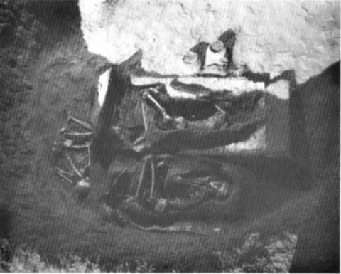
but it would be a delicate matter to trace a direct link.In the Middle Kerma period, 2050-1750 BC, the circular pits are generally of large dimen- sions. Entire flocks of sheep now accompany the deceased, while ever more numerous recep- tacles contain food supplies and prime necessi- ties. The sheep are placed south and west of the dead person, sometimes with a dog also, and one or more human sacrifices, while the pottery and joints of butchered animals are placed to the north, on a small table or directly on the ground. This distribution, practically unchang- ing, confirms the duality which exist between these offerings of different types.
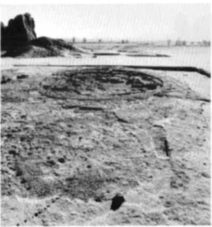
During the Middle Kerma period there also appear the first chapels in mud-brick to the northwest of the tombs (FIGURE 16). If, to begin
with, these oratories are very small, they rapidly become much larger. On the ground or in front of the entrances, deliberately broken ceramics again attest funerary rites, including libations. We observe a perceptible increase in human sacrifices. One or two adults and up to seven children are sometimes found beside the main subject. On several occasions, a man, lying on a wooden bed, was accompanied by a woman and an adolescent. At the present time, we might suppose that these burials relate to a single family, where certain members agree to follow one of their own in death.
The Classic Kerma period, 1750-1500 BC, is
marked by the enormous size of some tombs,
FIGURE 16. Middle Kerma tomb and chapel. The oxheads are placed south of the entrance.
EXCAVATIONS AT THE NUBIAN ROYAL TOWN OF KERMA: 1975-91 62 3
where the superstructure is set on a network of parallel or radiating walls. True temples are associated with these immense tombs. Human sacrifices run into hundreds, which cannot have been without consequences in the demographic evolution of a relatively sparsely peopled kingdom (FIGURE 17). The grave-goods also illus- trate the prosperity of the period: piles of fine ceramics, jewels, arms, toilet objects, chests and beds of wood inlaid with ivory, etc. Objects of Egyptian manufacture, statues, inscribed vases or
stelae, obtained by exchange or salvaged from Egyptian fortresses, can be observed. In chapels and temples, ornamentation of faience often overlaid with gold leaf, mural paintings featuring processions of animals, boats and a few scenes from everyday life, also bear witness to the flowering of the civilization of Kerma (FIGURE 18).
Discussion
Although the data acquired up to now have considerably enriched our knowledge, they are only partial. Remember in particular that no other Kerrna settlement has yet been excavated. The few surveys carried out in the Kerma Basin have located substantial remains which imply a type of architecture in earth and stone different
FIGURE 17. Human sacrifices became more numerous at the end of the Middle Kerma period.
from that at Kerma. Only by extending research outwards will we be able to find regional centres of the hinterland, and thus to have some idea of the effective power of Nubian sovereigns.
The discovery by our Italian colleague R. Fattovich at Kassala, near the Ethiopian fron- tier, of seals and ceramics close to those at Kerma (Fattovich 1988: 423-301, allows us to envisage research programmes geared to the trade routes and evolution of cultures in central Africa, on the shores of the Red Sea or in the Sahara. Egypt turns towards Palestine and the Mediterranean: by its geographical position. Kerma is a link with a major part of the African continent. And the beginnings of history in this continent still remain to be found.
Bibliographical note
A fuller account, with a great many illustra- tions, of.Kerrna, is to be found in Bonnet et al. (1990), the large catalogue of an exhibition at the Musee d’art et d’histoire, Geneva, June- November 1990. The catalogue contains a full bibliography, so only selected references are given in this paper.
The papers in Bonnet et al. (1990) summarize discoveries 1988-1991.
624 CHARLES BONNET
References
ADAMS, W.Y. 1977a. Nubia, corridor to Africa. London: Allen Lane.
1977b. Reflections on the archaeology of Kerma, in Agypten und Kush. Schriften zur Geschichte und Kultur des alten Orients 13: 41-51. Berlin. Africa in antiquity. The arts of ancient Nubia and the
Sudan I & 11. 1978. New York (NY): Brooklyn Museum.
ARKELL, A.J. [1955] 1961. A history ofthe Sudanfrom the earliest times to 1821. London.
BIETAK, M. 1968: Studien zur Chronologie der
Nubischen C-Gruppe. Ein Beitrag zur Fruh- geschichte Unternubiens zwischen 2200 und
1550 vor Ch. Vienna: Osterreichische Akademie der Wissenschaft. Phil.-hist. K1. Denkschriften 97.
FIGURE 18.
Funerary chapel of a Classic Kerma princely tomb. BONNET, C. 1977-1991. Les fouilles archeologiques de
Kerma (Soudan). Rapports preliminaires des campagnes de 1977 a 1991, Genava (n.s.) 26: 107-27: 28: 31-62: 30: 29-93: 32: 5-20; 34: 5-20; 36: 5-20; 39 (see below, Bonnet et al. 1990).
1986. Kerma, territoire et metropole. Quatre leCons au College de France, Bibliotheque g6n6rale de I’Institut f r u n p i s d’archeologie orientale 9. Cairo.
BONNET, C. et al. 1990. Kernia, ropaume de Nubie. Geneva: Mission archeologique de I’Universite de Geneve au Soudan.
1991. Kerma, Soudan 1988-1989 - 1989-1990 -
1990-2991, Genavo (n.s.) 39, comprising: - BONNET, C. 1991. Les fouilles archeologiques de
Kerma (Soudan): rapport preliminaire sur les campagnes de 1988-1989, de 1989-1990 et de
EXCAVATIONS A T THE NUBIAN ROYAL TOWN OF KERMA: 1975-91 625 1990-1991, Genovo (n.s.) 39: 5-20. (English text:
The archaeological excavations at Kerma (Sudan): preliminary report on the 1988-1989, 1989-1990 and 1990-1991 seasons, Genava (n.s.) 39: I-Vl.)
- BONNET, C. & MAHMOUD ELTAYEB MAHMOUD. 1991. Une tombe meroitique du cimetiere de la ville antique, Genovo (n.s.) 39: 29-34. (English text: A Meroitic tomb from the cemetery of the ancient town, Genavo ( n s ) 39: XIII-XIV.)
- BONNET, C. & SALAH EL-DIN MOHAMED AHMED. 1991. Un atelier de potiers d’epoque napateenne et quelques tombes chretiennes, Genava (n.s.) 39: 25-8. (English text: A potter’s workshop of the Napatan period and some Christian tombs, Genova (n.s.) 39: XI-XII.)
- GRATIEN, B. 1991. Empreintes de sceaux et admin- istration a Kerma (Kerma Classique), Genova (n.s.) 39: 21-4. (English text: Seal impressions and administration at Kerma in the Classic Kerma period, Genova,(n.s.) 39: VII-IX.)
- SIMON, C. 1991. Etude anthropolgique de squelet- tes provenant d’une tombe chretienne d e Koya et
d’une tombe meroi‘tique de Kerma, Genava (n.s.) 39: 35-41. (English text: An anthropological
study of human skeletons from a Christian tomb at Koya and a Meroitic tomb at Kerma, Genava (n.s.) 39: XV-XIX.)
DUNHAM, D. 1982. Excavations at Kerrna part VI. Boston (MA): Museum of Fine Arts.
FATTOVICH, R. et 01. 1988. Societa e territorio nel Delta del Gash (Kassala, Sudan orientale) 3000 a.Cr. -3001400 d.Cr., Africo 43(3): 394-453.
GRATIEN, B. 1978. Les cultures Kerma: essai de classification. Lille.
1986. Sol I: La NCcropole Kerma. Paris: CNRS. JUNKER, H. 1921. Der nubische Ursprung der sogen-
nanten Tell el-Johudiye Vasen. Vienna: Akade- mie der Wissenschaften in Wien. Phil.-hist. K1. Sitzungberichte 198(3).
1932. Bemerkungen zur Kerma-Kunst, in Studies in
honor of F.L. Griffith: 297-303. London: Egypt Exploration Society.
MAYSTRE, C. 1986. Tabo I. Geneva: Georg.
REISNER, G.A. 1923. Excavations at Kerma parts I-V, Harvord African Studies 5-6.
TRIGGER, B.G. 1976. Nubio under the Pharaohs. London: Thames & Hudson.
TRIGGER, B.G. et al. 1983. Ancient Egypt: a social history. Cambridge: Cambridge University Press.