HAL Id: hal-01499439
https://hal-univ-paris.archives-ouvertes.fr/hal-01499439
Submitted on 31 Mar 2017
HAL is a multi-disciplinary open access
archive for the deposit and dissemination of
sci-entific research documents, whether they are
pub-lished or not. The documents may come from
teaching and research institutions in France or
L’archive ouverte pluridisciplinaire HAL, est
destinée au dépôt et à la diffusion de documents
scientifiques de niveau recherche, publiés ou non,
émanant des établissements d’enseignement et de
recherche français ou étrangers, des laboratoires
mantle subduction, and oblique, strike-slip controlled
growth of the Tibet plateau
B Meyer, P Tapponnier, F Bourjot, F Métivier, G Gaudemer, G Peltzer, Guo
Shunmin, Chen Zhitai
To cite this version:
B Meyer, P Tapponnier, F Bourjot, F Métivier, G Gaudemer, et al.. Crustal thickening in
Gansu-Qinghai, lithospheric mantle subduction, and oblique, strike-slip controlled growth of the Tibet
plateau. Geophysical Journal International, Oxford University Press (OUP), 1998, 135, pp.1 - 47.
�10.1046/j.1365-246X.1998.00567.x�. �hal-01499439�
Crustal thickening in Gansu-Qinghai, lithospheric mantle
subduction, and oblique, strike-slip controlled growth of the
Tibet plateau
B. Meyer,1 P. Tapponnier,1 L. Bourjot,2 F. Me´tivier,1 Y. Gaudemer,1 G. Peltzer,3
Guo Shunmin
4 and Chen Zhitai5
1 L aboratoire de T ectonique, CNRS-UMR 7578, Institut de Physique du Globe, 4 place Jussieu, 75252 Paris cedex 05, France 2 Universite´ de Savoie, Chambe´ry, 73000, France
3 Jet Propulsion L aboratory, 4800 Oak Drive, Pasadena, CA 91109, USA 4 State Seismological Bureau, 63 Fuxing Road, Beijing, China
5 Institute of Seismology, 20 Donggangxi Road, L anzhou, China
Accepted 1998 February 7. Received 1997 December 19; in original form 1997 August 1
S U M M A R Y
Fieldwork complemented by SPOT image analysis throws light on current crustal shortening processes in the ranges of northeastern Tibet (Gansu and Qinghai provinces, China). The ongoing deformation of Late-Pleistocene bajada aprons in the forelands of the ranges involves folding, at various scales, and chiefly north-vergent, seismogenic thrusts. The most active thrusts usually break the ground many kilometres north of the range-fronts, along the northeast limbs of growing, asymmetric ramp-anticlines. Normal faulting at the apex of other growing anticlines, between the range fronts and the thrust breaks, implies slip on blind ramps connecting distinct active de´collement levels that deepen southwards. The various patterns of uplift of the bajada surfaces can be used to constrain plausible links between contemporary thrusts downsection. Typically, the foreland thrusts and de´collements appear to splay from master thrusts that plunge at least 15–20 km down beneath the high ranges. Plio-Quaternary anticlinal ridges rising to more than 3000 m a.s.l. expose Palaeozoic metamorphic basement in their core. In general, the geology and topography of the ranges and forelands imply that structural reliefs of the order of 5–10 km have accrued at rates of 1–2 mm yr−1 in approximately the last 5 Ma.
From hill to range size, the elongated reliefs that result from such Late-Cenozoic, NE–SW shortening appear to follow a simple scaling law, with roughly constant length/width ratio, suggesting that they have grown self-similarly. The greatest mountain ranges, which are over 5.5 km high, tens of kilometres wide and hundreds of kilometres long may thus be interpreted to have formed as NW-trending ramp anticlines, at the scale of the middle–upper crust. The fairly regular, large-scale arrangement of those ranges, with parallel crests separated by piggy-back basins, the coevality of many parallel, south-dipping thrusts, and a change in the scaling ratio (from #5 to 8) for range widths greater than #30 km further suggests that they developed as a result of the northeastward migration of large thrust ramps above a broad de´collement dipping SW at a shallow angle in the middle–lower crust. This, in turn, suggests that the 400–500 km-wide crustal wedge that forms the northeastern edge of the Tibet–Qinghai plateau shortens and thickens as a thick-skinned accretionary prism decoupled from the stronger upper mantle underneath.
Such a thickening process must have been coupled with propagation of the Altyn Tagh fault towards the ENE because most thrust traces merge northwestwards with active branches of this fault, after veering clockwise. This process appears to typify the manner in which the Tibet–Qinghai highlands have expanded their surface area in the Neogene. The present topography and structure imply that, during much of that period,
the Tibet plateau grew predominantly towards the northeast or east-northeast, but only marginally towards the north-northwest. This was accomplished by the rise, in fairly fast succession, of the Arka Tagh, Qiman Tagh, Mahan shan, Tanghenan Shan, and other NW-trending mountain ranges splaying southeastwards from the Altyn Tagh, isolating the Aqqik-Ayakkum Kol, Qaidam, Suhai and other catchments and basins that became incorporated into the highland mass as intermontane troughs. The tectonic cut-off of catchments and the ultimate infilling of basins by debris from the adjacent ranges, a result of tectonically forced internal drainage, have thus been essential relief-smoothing factors, yielding the outstandingly flat topography that makes Tibet a plateau.
Using Late-Mesozoic and Neogene horizons as markers, the retrodeformation of sections across the West Qilian Ranges and Qaidam basin implies at least #150 km of N30°E Neogene shortening. On a broader scale, taking erosion into account, and assuming isostatic compensation and an initial crustal thickness comparable to that of the Gobi platform (47.5±5 km), minimum amounts of Late-Cenozoic crustal shortening on NE sections between the Kunlun fault and the Hexi corridor are estimated to range between 100 and 200 km. In keeping with the inference of a deep crustal de´collement and with the existence of Mid-Miocene to Pliocene plutonism and volcanism south of the Kunlun range, such values suggest that the lithospheric mantle of the Qaidam plunged obliquely into the asthenosphere south of that range to minimum depths of the order of 200–300 km. A minimum of #150 km of shortening in the last #10 Ma, consistent with the average age of the earliest volcanic–plutonic rocks just south of the Kunlun (#10.8 Ma) would imply average Late-Cenozoic rates of shortening and regional uplift in NE Tibet of at least #15 mm yr−1 and #0.2 mm yr−1, respectively. Such numbers are consistent with a cumulative sinistral offset and slip rate of at least #200 km and #2 cm yr−1, respectively, on the Altyn Tagh fault east of 88°E. The fault may have propagated more than 1000 km, to 102°E, in the last 10 Ma.
Our study of ongoing tectonics in northeast Tibet is consistent with a scenario in which, while the Himalayas-Gangdese essentially ‘stagnated’ above India’s subducting mantle, much of Tibet grew by thickening of the Asian crust, as propagation of large, lithospheric, strike-slip shear zones caused the opposite edge of the plateau to migrate far into Asia. The Asian lithospheric mantle, decoupled from the crust, appears to have subducted southwards along the two Mesozoic sutures that cut Tibet north of the Gangdese, rather than to have thickened. The Bangong-Nujiang suture was probably reactivated earlier than the Jinsha-Kunlun suture, located farther north. Overall, the large-scale deformation bears a resemblance to plate tectonics at obliquely convergent margins, including slip-partioning along large strike-slip faults such as the Altyn Tagh and Kunlun faults. Simple mechanisms at the level of the lithospheric mantle are merely hidden by the broader distribution and greater complexity of strain in the crust.
Key words: deformation, fault propagation, fold and mountain growth, plate tectonics,
plateau building, Tibet.
1988). Some (e.g. Molnar et al. 1993; England & Houseman 1 I N T R O D U C T I O N
1986, 1989; Dewey et al. 1988) also invoke homogeneous thickening and shortening of the Asian lithospheric mantle, The high elevation and great crustal thickness of the Tibet
followed by convective removal of its lower part. plateau, between the Himalayas and the Kunlun, are generally
The lack of detailed mapping of Tertiary thrust zones within assumed to result from the India–Asia collision, but the
Tibet, the lack of high-resolution seismic studies of its deep processes that have led to the situation observed today remain
crustal and upper-mantle structure, the lack of convincing unclear. While Ni & Barazangi (1984) or Zhao & Morgan
evidence documenting the way in which its elevation changed (1985) relate the formation of the plateau to wholesale
since the Cretaceous, and the fact that it has been the site of underthrusting (Argand 1924), or to injection of the crust of
E–W crustal extension since the beginning of the Quaternary India beneath that of Asia, most authors view distributed
(e.g. Tapponnier et al. 1981; Armijo et al. 1986) have set the shortening and thickening of the Asian crust to have been the
stage for enduring controversy. Besides, most extant models dominant mechanism (e.g. Dewey & Burke 1973; Molnar &
focus on deformation in the Himalayas and within the plateau in the shortening process, the way in which the Tibet plateau developed, and the origin of its flat topography.
(Zhao et al. 1993; Nelson et al. 1996; Owens & Zandt 1997) rather than along its northern rim.
Active crustal shortening, however, occurs prominently
2 G R O W I N G R A M P AN T I C L I N E S , A C T I V E along and north of the Kunlun range, over much of northern
D E´ COLLEMENTS AND BRANCHING Qinghai and Gansu provinces, from the Qaidam basin to the
T H R U S T S I N T H E F O R E L A N D S O F T H E Tarim, Gobi and Alashan platforms (Fig. 1). This broad
moun-TA X U E H A N D moun-TA N G H E N A N R A N G E S tainous region forms the northeastern edge of the Tibet
high-lands. North, east and west of the Qaidam, it is composed of
2.1 Morphology and age of the mountain piedmonts roughly parallel NW–SE-trending ranges, several hundreds of
Steep mountain range fronts in NE Tibet (Fig. 1) generally kilometres long and a few tens of kilometres wide (Qilian
rise 2–3 km above piedmont bajadas of great size. Such broad, Shan, Taxueh Shan, Sulenan Shan, Tanghenan Shan, Qiman
gently sloping Quaternary aprons result from the coalescence Shan, etc., Fig. 1). The ranges tower to 5500–6000 m, more
of alluvial fans fed by the many streams that flow out of the than 4000 m above the Gobi desert. They are separated by
ranges. The bajada shown in Fig. 2(a), along the northern intermontane basins with altitudes between 2000 and 4000 m.
piedmont of the Taxueh Shan, south of Changma, is a typical The average topographic elevation (approximately 3500 m),
example. The fanglomerates that compose its apron have been the presence of Quaternary folds and thrust faults (Guo &
deposited as fluvial or fluvio-glacial terraces. While all of them Xian 1985; Xu et al. 1989; Tapponnier et al. 1990a; Meyer
are of Late Quaternary age, they are not coeval. To a first 1991; Zhang et al. 1991), the level of historical and instrumental
order, on the SPOT image and in the field, three groups of seismicity (Institute of geophysics 1976), and thrust fault-plane
deposits of increasing relative ages (a3, younger than a2, itself solutions (Tapponnier & Molnar 1977; Molnar & Lyon-Caen
younger than a1) may be distinguished on the basis of clast 1989; Ekstro¨m 1987; Chen et al. 1996) (Fig. 1) concur to
size and consolidation, colour and relative elevation of the indicate that these mountain ranges are still growing, to
surfaces that cap them, and degree of incision of such surfaces accommodate thickening of the crust. In the Qaidam basin,
by erosion. seismic profiles and borehole data suggest that thrust faulting
On the images of Figs 2, 3, 4 and 5, for instance, the dark and folding began after the Cretaceous, were most active in
linear swaths correspond to the flood channels of the contem-the Mio-Pliocene, and continue at present (Bally et al. 1986).
porary drainage, floored by the youngest ( lowest) deposits of The region located north of the Kunlun is thus well suited
the bajada (a3). The dark-grey colour results from denser to study the mechanisms by which thickening of the crust of
vegetation due to more abundant seasonal and subsurface Asia now takes place, as well as whether and how the
lithosph-water in the stream beds. Typically, such streams have incised eric mantle is involved. A strong incentive for such a study is
several metres below the average level of the bajada. that this region may be viewed as a young outgrowth of the
The surface that forms the bulk of the bajada apron (a2) Tibet plateau proper, with which it is contiguous (e.g. Molnar
has a rather uniform light-grey hue on the SPOT image & Tapponnier 1978). Hence, deformation mechanisms at work
(Fig. 2a). It has little internal relief, with only small rills, here today may resemble those that have contributed to the
generally less than a couple of metres deep, meandering on its formation of the plateau.
top. Due to loess accumulation in them, the rills are a lighter As a step towards elucidating such mechanisms and their
shade of grey. In the field, much of a2 itself is in fact coated bearing on the growth and uplift of orogenic high plateaus,
by a thin blanket of loess, a few centimetres to over one metre we document here the existence, extent, and geometry of active thick. The blanket becomes thicker southwards, as reflected thrusts and growing folds in some of the mountains of Qinghai
by its smoother texture and lighter, more even colour on the and Gansu. Our study is based on fieldwork, guided and image (Figs 2a,b). Farther south, near the foot of the range, complemented by SPOT image analysis. Two regions, at the the uniform, barren bajada blends with a more densely incised northern foot of Taxueh Shan, and of Tanghenan Shan, were and vegetated (darker) surface. We interpret the more rugged targets of more detailed investigation and mapping. Particular morphology to result from the proximal accumulation of attention was given to quantitative assessment of the mor- coarser debris of morainic origin, reworked by the streams phology, using either topographic maps (at scales of 15105 and that fan out when escaping the glacial valleys that reach the 15106) or levelled surface profiles. range front (Fig. 2).
We combine geological and structural observations with The oldest bajada fanglomerates are exposed along two measurements of surface warping and deformation to clarify narrow, ESE-trending zones that are conspicuous on the SPOT fold growth, the relationship between folding and faulting, and image (Figs 2a,b, and for greater detail, Figs 4a,b, and 5a,b). to constrain plausible shapes of active thrusts down-section. In both zones, such fanglomerates lie above, and are more We then use the insights gained on the geometry of thrust incised than the rest of the bajada apron (Fig. 4c), even though faulting along the Taxueh and Tanghenan Shan, with they appear to merge with it upstream or, at places, down-additional evidence from the Qilian Shan (Peltzer et al. 1988; stream. Occasionally, the surfaces that top them stand at Tapponnier et al. 1990a; Meyer 1991; State Seismological somewhat different levels, a few metres apart (Fig. 4e). Overall, Bureau 1993) and the Qaidam basin, to draw inferences on however, these levels may be seen as only slightly diachronous the growth of the mountain ranges and thrusts, on the large- components of a distinct terrace surface (a1), which forms the scale organization of crustal shortening, and on its relationship highest and oldest geomorphological unit of the bajada. to strike-slip faulting. We finally attempt to place bounds on The relative age inferred from morphological evidence for the amounts and rates of Late Neogene shortening and faulting each of the three units is consistent with the aspects of the fanglomerates in outcrop. Loose gravel and pebbles mixed north of the Kunlun, and discuss the role played by the mantle
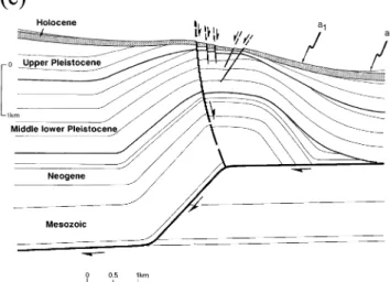
Figure 1. Seismotectonic map of Qinghai–Gansu highlands. The insert shows the location of the region relative to Tibet and within eastern Asia. Active and Quat ernary features (faults and folds) are from our fieldwork and Landsat and SPOT image analysis. Elevation contours are from ONC chart G8 (Defense Mapping Agency 1973, 1989 ). Earthquake ep icentres are from the catalogue of strong shocks of China (Institute of geophysics 1976; Gu et al . 1989 ). F ault-plane solutions are from Molnar & Lyon-Caen (1989 ). Boxes with numbers refer to areas of Figs 2 and 9. Thin dashed lines are sections in Fig. 17. TQK is T a Quen Kou basin, where piedmont bajada surface loess has been dated (Meyer 1991 ).
Figure 2(a). Part of panchromatic SPOT scene KJ 240–270 ( 12/11/87; pixel-size, 10 m).
Figure 2(b). Morphotectonic map of Fig. 2(a). Taxueh Shan piedmont is mantled by large postglacial bajada. Three fanglomerate units and
surfaces of different ages are distinguished: a3, contemporary stream-channels; a2, coalescent fans of main bajada surface; a1, oldest fanglomerates along narrow EW zones of tectonic uplift corresponding to growing anticlines (thin dashed lines, anticlinal axes). Elevation contours are from PRC 1 : 105 topographic maps, Chang Ma and Sandou Gou sheets. Boxes indicate locations of Figs 4 and 5.
a distance of #20 km. On the north flank of Taxueh Shan, whose summit peaks at 5681 m, the tips of contemporary glacier tongues reach down to 4200–4300 m, approaching to within 5–6 km of the range front. The present-day snowline roughly follows the 4700 m elevation contour, while the perma-frost line, the lower limit of the periglacial zone, is near 3700 m (Wang & Derbyshire 1987). Where fresh-looking and well preserved, the lowest Wu¨rm terminal moraines in the northern Taxueh Shan stand at about 3600 m, 800–900 m below the present ones (Peltzer et al. 1988). Hence, during the last glacial maximum, large Wu¨rm glaciers probably flowed out of the range onto the uppermost part of the piedmont, while much of that piedmont was within the periglacial domain, a situation similar to that in the Ta Quen Kou basin (TQK, Fig. 1), 90 km to the east (Peltzer et al. 1988). We thus infer the morainic debris along the foot of Taxueh Shan (Fig. 2) to be mostly of late Wu¨rm age (20–15 ka BP, e.g. Duplessy et al. 1988; Bard et al. 1990). At that time, much of the piedmont surface was probably smoothed out by efficient, periglacial mass transport processes (e.g. cryoplanation, gelifluction, etc.). Such superficial processes would not have allowed preservation of small-scale relief such as the fine incision network now visible on a1 or a2. Hence, that pluvial network, as well as the surfaces that bear it and their loess blanket, ought to postdate the Wu¨rm glacial retreat.
Thermoluminescence dating, with one-year-long dosimeter calibrations, of a comparable loess blanket, approximately 90 cm thick, sampled at two sites in the nearby Ta Quen Kou basin corroborates this inference. Both sampling sites yield comparable, upward-decreasing age sequences of 11.5±1.5 ka, 6.6±2.2 ka, 3.6±0.6 ka, and 9.4±1 ka, 4.4±0.7 ka, 1.8±0.35 ka, at shallowing depths of 80, 55, and 30 cm (Meyer 1991). The loess layer thus postdates 10.7±2.3 ka BP, and most of the a2 fanglomerates of the bajada were deposited as a result of increased run-off in the piedmont prior to 8.4 ka BP, around the beginning of the Holocene. Even the oldest surface (a1) probably represents remnants of a terrace emplaced after deglaciation started (#14 ka BP, Fairbanks 1989; Bard et al. 1990).
Together with the Yumu Shan bajada, 300 km eastwards (Fig. 1), whose age also appears to be mostly Holocene (e.g. Tapponnier et al. 1990a), the Taxueh Shan bajada is the foreland fanglomerate apron that we studied in most detail. We infer, however, from their similar aspect on SPOT images and topographic maps, that many other Quaternary bajadas
Figure 3(a). South-looking view of Taxueh Shan Piedmont. The
growing north-hills anticline is in the foreground, with the emergent that reach elevations≥2000 m at the foot of the great ranges
thrust activated by the 1932 Chang Ma earthquake along its front (see of northeastern Tibet have a similar age and origin. In
particu-Fig. 3b). The south-hills anticline is discernable in the right- lar, we assume that large areas of the northern foreland middleground. The highest peak of the Taxueh Shan range (5681 m) of Tanghenan Shan (Fig. 1) are mantled by postglacial or dominates the background. (b). Southeast-looking views of the 1932 holocene fanglomerates.
Chang Ma earthquake surface break (white arrows) at site b in Fig. 2( b). (c). As (b), for site c.
2.2 Shortening in the Taxueh Shan piedmont
The two narrow zones where the highest terrace (a1) is exposed across the Taxueh Shan piedmont trend roughly perpendicular with sand and silt fill the a3 channels, while alternating layers
of sandy and pebbly conglomerate characterize a2. Better to the drainage direction (Fig. 2). In the field, both zones thus form rows of hills separated by contemporary drainage chan-cemented, more consolidated, cobbly conglomerate is
associated with a1. nels (Fig. 3a). The hills stand above the average surface of the bajada apron (a2), interrupt its continuity, and break its The average elevation of the Taxueh Shan piedmont is high
(#3100 m). From about 3600 m at the foot of the range (Fig. 2) otherwise uniform slope (Figs 2, 3, 4 and 5). There is ample evidence, described below, that such hill rows are of tectonic the bajada descends regularly northwards to about 2600 m (at
Figure 4(a). Detail of panchromatic SPOT scene KJ 240–270 ( 12/11/1987; pixel size, 10 m).
Figure 4(b). Morphotectonic map of (a). Spearheaded, almond-shaped tongues of uplifted terrace a1, separated by bottleneck cluses of
contemporary streams, signal the growth of the north-hills anticline south of the festooned thrust trace. Such tongues vanish where thrust-trace segment terminates or steps over, or where depositional surface is younger. Thin dashed lines are streambed and hilltop profiles of Fig. 4(f ).
Figure 4(c). Detail of 1 : 105 topographic map in the north-hills anticline area. Tees with capital letters mark extremities of profile pairs of Fig. 4(d). Inset on right shows precise location and trace of levelled field profiles.
ridges above south-dipping thrust ramps. For lack of local view, the stream channels that wander within the generally divergent fan pattern of the bajada tend to converge into fewer toponyms to designate these features, we refer to them as the
north- and south-hills anticlines. channels as they cross the hill zone. Water flow is thus funnelled into bottleneck narrows, or ‘cluses’, that separate (Fig. 3a) almond-shaped patches of uplifted terrace (a1), elongated in 2.2.1 North-hills (Beishanzi ) anticline
the direction of flow (Figs 4a,b and c). Upstream, such terrace patches merge smoothly with the bajada surface (a2), forming The north side of the northern hill row, about 16 km north of
the range front, is bounded by a thrust fault—the Taxueh Shan spearheaded tongues, as the amount of relative uplift between a1 and a2 gradually decreases (Figs 4b and c). Downstream, piedmont thrust—whose trace is conspicuous on the SPOT
image (Figs 2 and 4a,b). The thrust trace, about 30 km long, by contrast, the active thrust sharply truncates the patches at their widest. On the images, on the 15105 topographic map is composed of right-stepping, en e´chelon segments with
fes-tooned shape (Figs 2 and 3c). The segments along the biggest (Figs 4a and c) and in the field, there is good evidence that the stream channels crossing the north-hills anticlinal ridge hills display clear south-pointing cusps at intersections with
main stream channels (Figs 2 and 4), as expected for a south- became narrower and deeper, and hence more localized, by successively abandoning older terrace levels on the sides. The dipping thrust. At both ends of the thrust trace (NW and SE
corners of Figs 2a,b) we found, and followed for a few existence of such levels adds to the composite, locally diachronic nature of a1.
kilometres in the field, a north-facing, 30–75 cm high scarp
(Figs 3b,c). The freshness of that scarp [exposed gravels on its Sections along stream channels show the uppermost fanglo-merates, which roughly parallel the top surface of terrace a1, rather steep face (25–30°N), small bushes aligned along its
base, or in places loose soil without turf, as if freshly plowed, unconformably capping gently folded, more consolidated fang-lomerates (Figs 4e and f ). The angle of unconformity is in and small pressure ridges poked with rodent holes] implies
that it is a surface break of the 1932 December 25, M=7.6, general small, varying across section from a few degrees in the south to about 10° in the north. Steeper dips (up to 30°N) Chang Ma earthquake, making the Taxueh Shan piedmont
thrust one of five large fault strands ruptured by that great locally exist near the cumulative thrust scarp (Fig. 4f ). Folding of the Late Quaternary piedmont fanglomerates thus appears earthquake (Meyer 1991).
The maps and sections of Fig. 4 display the morphology to increase with deposition age and is asymmetric (north-facing), a straightforward consequence of north-vergent thrust-and superficial structure of the northern hill row, as well as
the geometry of the underlying anticline (north-hills anticline) ing. Although exposure is limited to cliffs at most #20 m high (Figs 4c and e), it is likely that the degree and asymmetry of and of the thrust ramp compatible with that structure. In map
Figure 4(d ). Hilltop/streambed profile pairs derived from map of Fig. 4(c). The shape of the north-hills anticlinal bulge is visible on all profiles.
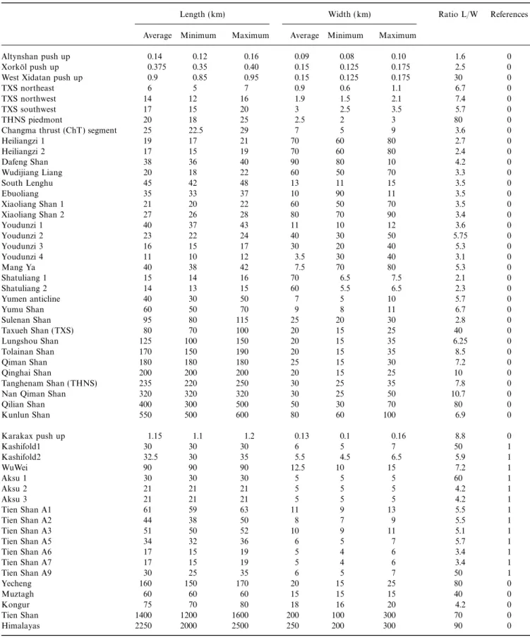
Parameters derived from the profiles are summarized in Table 1.
folding increase further with depth. 15 km to the northeast, at most prominent unconformities within that sequence ought to correspond chiefly to the onsets of interglacial periods (for Xiao Kouzi, in the hanging wall of another north vergent
active thrust, the Changma thrust (Meyer 1991), a tight example, the folded #125 ka unconformity represented in Fig. 4f ).
recumbent fold of Cretaceous red beds (Gansu Geological
Bureau 1975) is exposed under the gently warped, distal In summary, the northern hill row is a remarkable example of the geomorphic expression of an active fault-propagation fanglomerates of the Taxueh Shan Bajada, here only a few tens
of metres thick (Meyer 1991). Hence, we infer the base of the anticline in a rather dynamic environment of fluvial deposition. Because of its exceptional location within a periglacial area, it much thicker fluvio-glacial Quaternary sequence beneath the
northern hill row to be folded in a comparable tight manner provides a ‘snapshot’ (with a geological ‘exposure time’ of about 14 ka) of a ramp anticline caught in the process of active (Fig. 4f ), within the faulted, asymmetric core of the north-hills
in the Liupan Shan, east of Gansu, range mostly between 40° and 60°. More specifically, where exposed in a small gully east of Sange Quan, #20 km east of the north-hills anticline, the measured dip of the Changma thrust, closest neighbour of the Taxueh Shan piedmont thrust, is 40°S (Meyer 1991; State Seismological Bureau 1993). 80 km eastwards, the Ta Quen Kou fault, which may be considered an eastern splay of the Taxueh piedmont Shan thrust, dips 55°±5°S (Peltzer et al. 1988). We thus take 45°±15°S to be the most plausible dip of that thrust under most of the northern hill row.
It is possible to infer more about the depth and kinematics of thrusting with a quantitative assessment of the relief above it. The amount of surface warping recorded by the visible uplift of the postglacial terraces may be obtained, at comp-lementary scales, from the 15105 topographic maps and from levelling in the field. The difference between paired profiles roughly perpendicular to the thrust, one across a given hill
Figure 4(e). East-looking view of the slight angular unconformity of
(a1), the other along an adjacent stream channel (a3), yields
a1 upon gently south-dipping upper-Pleistocene fanglomerate beds on
the width and amplitude of the anticlinal bulge relative to the
the southern top part of the north-hills anticline.
contemporary depositional surface. Fig. 4(d) shows 10 pairs of 7–9 km long profiles across the western part of the north-hills anticline, derived from the map of Fig. 4(c). Although precision is limited by the equidistance of the elevation contours on that map (20 m), the anticlinal shape of the hills is clear on all the profiles, being constrained by at least three point pairs. The anticlinal bulge makes only a local disturbance, up to 25 m high and 1.4–2.1 km wide, on the otherwise regular bajada surface (Fig. 4d, Table 1). As befits sedimentary fans, the bajada is in general slightly concave upwards, with a slope angle of as much as 3.2°N south of the anticline and as little as 2.5°N north of it (Fig. 4d, Table 1). The width and height of the bulge diminish both eastwards and westwards (Fig. 4d, Table 1), towards the extremities of the corresponding thrust segment, in keeping with the decrease in length of the a1 terrace tongues (Fig. 4b).
A more accurate shape of the anticlinal bulge was obtained
Figure 4(f ). Top: difference between hilltop (P2) and streambed
by levelling, using a digital-recording theodolite distancemeter
(P1) profiles near the centre of the north-hills anticline ( location on
Figs 4b,c). Small circles are levelling points. Both profiles are projected (Wild T 2000-DI 3000), two approximately NS profiles about
on N–S- and N21°E-striking vertical planes, south and north of the 2.5 km long (P1 and P2, Figs 4b,c and f ) across a typical black circles, respectively (see also inset in Fig. 4c). Bottom: cross-section spearheaded terrace tongue and adjacent bottleneck cluse near of the anticline beneath the profile, derived from field observations the centre of the thrust segment (for technical details and and regional geological evidence. The degree of folding increases with
measurement errors, which are less than 20 cm in height and
depth. The progressive growth of the anticline accounts for thinning
less than 2 m in horizontal position, see Peltzer et al. 1988,
of sedimentary layers above the thrust ramp, taken to dip 45°S.
Avouac et al. 1993 and Gaudemer et al. 1995). The highest
Unconformities are assumed to correspond to the onset of the last
stand of terrace a1 on the hill top lies 25±0.5 m above the
two interglacials. The thickness of Quaternary is taken to be similar
stream bed below (a3). The asymmetric shape of the anticlinal
to that in neighbouring sites where stratigraphic log is known (Gansu
bulge comes out clearly on the hill-top profile. The gentle
Geological Bureau 1975; Xu et al. 1989). Postglacial fanglomerates
are shaded. See discussion in text. (#1.2°N), undisrupted slope of the south limb, #1.9° less than
the local bajada slope, contrasts with the rather steep (#20–25°N on average), #10–12 m high cumulative scarp to ‘spearheaded’, ‘almond-shaped’ terrace tongues, all of them
truncated by fresh surface scarps that testify to seismic the north. The zone of uplift is #1.6 km wide, close to the average bulge width (#1.8 km) visible on the SPOT image movement on the thrust ramp underneath.
Since the Taxueh Shan piedmont thrust splays and shallows and derived from Figs 4(c and d) (Table 1). Although there is #4 m of local entrenchment of the contemporary stream-bed near the surface (Figs 3c, 4b,f ), its average dip under the
north-hills anticline may only be estimated. In general, dips of active near the cumulative scarp, there seems to be no detectable cumulative vertical offset of the bajada slope upstream and continental thrust ramps in sediments vary between 30° and
70° (e.g. Yeats 1983, 1986; Suppe 1983; Philip & Meghraoui downstream from the anticline, within the precision of our measurements. Nor is there any great change in the bajada 1983; Tapponnier et al. 1990a; Meyer et al. 1990; Chen et al.
1996). Avouac et al. (1993) found such thrust ramps to dip slope gradient (#3.1°N upstream, and #2.6°N downstream), whose average (2.85°N) is identical to the 20 km average and 55±5°S along the Dzungarian piedmont of the Tien Shan, in
a Quaternary tectonic environment broadly comparable to to the long-profiles slope average (Table 1). The topographic measurements thus support quantitatively the observation, in that of western Gansu. Dips measured by Zhang et al. (1991)
Figure 5(a). Detail of panchromatic SPOT scene KJ 240–270 ( 12/11/1987; pixel size, 10 m).
Figure 5(b). Morphotectonic map of Fig. 5(a). Spearheaded almond-shaped tongues of uplifted a1 and a1–2 (stripes) terraces, due to fold growth,
are not truncated by thrust trace. Roughly parallel scarps facing south (sunlit) or north (shaded) along the anticline apex (see Fig. 5a) testify to active surface deformation, in all likelihood normal faulting, near its hinge.
than the entrenchment of a3 near the thrust scarp and probably small enough to have been smoothed out by deposition or erosion processes away from the thrust. It seems doubtful, however, that such processes could smooth out more than a few metres of uplift. We conclude that a de´collement south of the north hills would be unlikely to dip south by more than #10°, and take 5°±5° as the most plausible value. With the rules commonly used to constrain the geometry of growing fault-propagation folds (e.g. Suppe 1983; Jamison 1987) and the dip assumed for the thrust ramp, bulge widths of 1.6–1.8 km would imply depths of #1.1–1.2 km for the ramp termination or ramp-to-flat kink (Fig. 4f ), appropriate for it to lie in the weak upper-Neogene mudstones under the coarse, competent lower Quaternary conglomerates (Xiyu fm.) that characterize the regional late-Cenozoic sedimentation here, as in much of western China (e.g. near Yumen, State Seismological bureau 1993; in the Tien Shan, Avouac et al. 1993).
Figure 5(c). Plausible cross-section of the south-hills anticline
con-sistent with surface observations on the SPOT image. The south-hills 2.2.2 South-hills (Nanshanzi ) anticline
anticline is inferred to result from fault-bend folding above blind ramp
About halfway between the trace of the emergent Taxueh Shan
linking two active de´collement levels. Kinematic compatibility results
piedmont thrust ramp and the range front, #8 km south of
in hinge-normal faulting. Triple junction instability may cause
hanging-wall normal faults to stop and move passively towards the foreland the north-hills anticline, bottleneck cluses in the drainage,
(e.g. Avouac et al. 1992). Stratigraphy, as in Fig. 4(f ). Due to lack of separating almond-shaped patches of uplifted, incised terrace
field measurements, this section is more qualitative than that of fanglomerates (a1) signal the existence of another contempor-Fig. 4(f ) (see discussion in text). ary anticline, the south-hills anticline, whose growth has formed
the other hill row of the piedmont (Figs 2 and 5).
map view on the SPOT image, that a1 and a2 merge upstream The morphology of the southern hill row, which we could and that stream channels are not deeper south than north of not reach in the field, differs from that of the northern one. the anticline. On the SPOT image, the terrace tongues have a more sym-That the bajada slope is not offset or warped on a large metrical shape, with spearheaded tips both upstream and scale, except within a few hundred metres of the cumulative downstream, and no trace of an active thrust trace truncating thrust scarp on the stream-bed profile, implies either that the them either to the north or south (Figs 5a and b). Many thrust plane terminates downwards at a shallow depth, at most parallel #EW-striking fault scarps cut the upper surface of of the order of the anticlinal bulge width, or that it kinks the almond-shaped terrace patches where they are widest and rather sharply at such depth into a de´collement (Fig. 4f ). highest, therefore roughly at the apex of the anticline. The Given the accuracy of our field profiles, such a de´collement scarps tend to be right-stepping, slightly oblique to the anti-would have to dip at a very shallow angle. Assuming the thrust clinal axis. In general, the northernmost scarps are lit by the ramp under the north-hills anticline to dip 45°S, and resolving sun, i.e. face towards the south, while the southernmost ones the 25 m surface uplift of a1 on the deeper part of that ramp are shaded and face north (Figs 5a and b). The scarps that implies #33 m of postglacial slip on it. This amount of slip face north tend to be more continuous and prominent than on a de´collement dipping 10°S would have generated #7.5 m those that face south. To the east, a particularly large, north-of cumulative uplift south north-of the anticline. Since the bajada facing, ENE-striking scarp appears to crosscut smaller scarps surface (a2) is younger than a1, the vertical uplift of its slope that more closely parallel the average strike of the anticlinal
axis. could plausibly be a few metres only, an amount no greater
Table 1. Dimensions of north-hills anticlinal bulge, derived from sections in Fig. 4.
Hilltop/streambed Profiles length Upstream Downstream Bulge width Bulge height
profiles ( km) slope (°) slope (°) (km) (m)
BB∞/AA∞ 9 2.6 — 1.5 12.5 CC∞/DD∞ 9 2.7 — 2.1 19 EE∞/FF∞ 8.5 3 2.5 2.1 18 GG∞/HH∞ 8 3.2 — 1.9 22.5 II∞/JJ∞ 7.75 3.2 2.75 2 22.5 KK∞/LL∞ 7.75 3.2 2.8 2 19 MM∞/LL∞ 8 3.1 2.9 2 25 OO∞/NN∞ 7.5 3.2 2.9 1.5 20 PP∞/QQ∞ 7.5 — 3.1 1.7 16 RR∞/QQ∞ 7.25 — 3.1 1.4 15 Average #8 km #3° #2.85° #1.82 km #19 m P2/P1 2.5 3.1° 2.6° 1.62 25
With the SPOT image as sole source of information, we can fresh, steep, conjugate surface scarps along the hinge of the anticline. Such scarps are most simply interpreted to reflect assess only qualitatively the main traits of the structure of the
south-hills anticline, by comparison with that along the north compatibility normal faulting due to bending of the strata within a seismically growing fault-bend fold (Fig. 5c) (e.g. hills. The length of the uplifted terrace patches is about 3.5 km
on average, everywhere greater than the maximum width of Avouac et al. 1992). Despite the lack of topographic profiles, the apparent incision depth on the SPOT image suggests that, the north-hills anticline (2.1 km), (Figs 2, 4 and 5). The
channels that separate these patches, and certain rills that like the north-hills anticline, the south-hills anticline is a localized bulge within the bajada apron (Fig. 2). Hence, the incise their surface, seem to have somewhat greater depths and
steeper sides than channels and rills in the north hills. The blind ramp beneath it extends downwards to only limited depth. The section drawn on Fig. 5(c), which we find to be, for spearheaded a1 tongues north of the anticlinal axis tend to be
shorter than those south of it, reflecting some degree of reasons discussed below, most consistent with surface evidence, depicts the blind ramp linking two de´collement levels at asymmetry, with the north limb of the anticline being somewhat
steeper than the southern one. different depths within the sedimentary cover (Fig. 5c). The multiple scarps along the axis of the anticline must
result from contemporary faulting because they can be traced
2.2.3 Overall geometry of thrusting across most of the rills that incise the terrace surface. The
rectilinearity of their traces suggest faulting on steep planes. That contemporary shortening north of the Taxueh Shan involves the coeval growth of two different, roughly parallel, By comparison with the rills they cut, we infer these scarps to
be a few to several metres high, a cumulative result of repeated ramp anticlines, 20–30 km long and as much as 8 km apart within the piedmont bajada (Figs 2 and 6a,b), makes it worth slip during earthquakes comparable to, and in all likelihood
including, that of 1932. Although the location of the scarps examining whether they are related to one another, and how. implies that they reflect deformation during incremental fold
growth, the exact deformation mechanism is harder to assess short of detailed fieldwork. The simplest interpretation is that the scarps result from roughly conjugate normal faulting at the apex of the anticline (Fig. 5c). A somewhat greater amount of downthrow towards the north would account for the slight pre-eminence of the north-facing scarps and a small component of left-slip, for their right-stepping, en e´chelon arrangement (Figs 5a and b). This overall geometry is closely comparable to that of the normal fault array at the apex of the anticline along the central segment of the Ech Cheliff thrust, in Algeria, that was activated by the 1980 October 10 El Asnam earth-quake (e.g. King & Vita-Finzi 1981; Philip & Meghraoui 1983; Meyer et al. 1990; Avouac et al. 1992). A different interpretation might be that such scarps, which are numerous, closely parallel to one another, and south- or north-facing, respectively, north or south of the anticline axis, result from flexural slip between competent beds in steep fold-limbs hidden beneath a relatively thin layer of unconformable Quaternary fanglomerates. Such a mechanism of deformation (Yeats et al. 1981) is common in young, growing folds north of the Qilian Shan and Tien Shan (Tapponnier et al. 1990a; Avouac et al. 1993). We doubt that it operates here, however, at least near the surface, because the most prominent scarps lie within a few hundred metres of the fold axis, in a narrow belt following the fold hinge, and because the thickness of rather gently dipping mid-upper Pleistocene fanglomerates close to the range front is unlikely to be less than a few hundred metres (Fig. 5c) (Gansu Geological Bureau 1975; Xu et al. 1989).
In summary, the evidence visible on the SPOT image implies that the southern hill row is the surface expression of a fairly broad feature, about twice the width of its counterpart along the northern hill row, and with somewhat greater amplitude. It probably folds a sedimentary pile about twice as thick. Like the north-hills anticline, the south-hills anticline is asymmetric (north-facing), which is consistent with north-directed slip on an underlying thrust ramp. The more subdued asymmetry
than that visible across the north-hills anticline, however, Figure 6. Sketch showing how observed warping and faulting in map implies that the upper tip of that ramp is fairly deep (e.g. view (a) and in cross-section ( b) might result from distinct thrust Suppe 1983; Stein & King 1984). That seismic slip currently geometries at depth (c,d,e,f ). (f ) is the most likely geometry, see text
for discussion.
Although such anticlines could reflect active thrusting on two independent ramps (Fig. 6c), we find this hypothesis untenable. Given the limited width of the anticlinal bulges, the ramps, whose most plausible dips are ≤60°, are unlikely to reach depths greater than #5–6 km and probably terminate short of the metamorphic basement, within Meso-Cenozoic sedi-ments. The north-hills ramp, which bears a surface break unquestionably related to the M#7.6 Changma earthquake, could not reach deeper than about 2 km, and more likely extends 1.1–1.2 km down, to near the base of the Quaternary conglomerates (Fig. 4f ). From a mechanical point of view, it is doubtful that such a shallow thrust could have been activated by such a large event without being physically connected to a deeper seismogenic structure. Therefore, we infer both ramps to be linked with a deep thrust fault, beneath the mountain basement to the south, by means of shallower-dipping flats, as shown in the sections of Figs 6(d)–(f ).
Further support for the hypothesis of interconnected south-dipping ramps and flats comes from the observation that the distances between the north- and south-hills anticlines, and between them and the range front, decrease as the Taxueh Shan foreland basin narrows, and hence shallows towards the east (Fig. 2). This implies that the depths of certain horizons, which depend on sedimentary thickness, exert a strong control on faulting (e.g. Armijo et al. 1986): the fold axes and underlying
ramps converge because the diminishing thickness of the Figure 7. Schematic sections showing the most plausible geometry of sedimentary cover causes such guiding horizons to shallow. active Taxueh Shan (a) and Tanghenan Shan (b) thrusts. In both cases, foreland de´collements (D1–D2, D, inferred to dip 5°S) splay from deep
Concurrently, the widths of the anticlinal bulges also decrease
thrust ramps under mountain ranges (F). Fault-propagation and
fault-from west to east (Fig. 2).
bend anticlines that fold piedmont bajada fanglomerates are due to
The observed surface deformation, combined with kinematic
the occurrence of shallower, blind (R2, section a) or emergent ramps
compatibility requirements, makes the section of Fig. 6(f )
(R3, section a; R2, section b). F, R2 and R3 are inferred to dip 45°S;
preferable to those of either Fig. 6(d) or (e). Section 6(d), in
R0 and R1, 60°S. Inset vector diagrams indicate the inferred
composi-which both the north- and south-hills ramps are inferred to
tion of slip components at fault triple junctions. Stratigraphic
thick-splay from the same flat, provides no plausible explanation for nesses are compatible with those known in western Hexi-corridor the fundamental difference between the two anticlines, i.e. for drill-logs (Gansu Geological Bureau 1975; Xu et al. 1989). Crosses the fact that the southern ramp remains blind, with only only represent pre-Mesozoic basement, without inference on rock type. normal faults at the surface. Rather, it maximizes internal Boxes are sections of Figs 4(f ) and 5(c).
shortening above the junction between that ramp and the flat, and ought to induce reverse faulting. Section 6(e), which
depicts a thrust triple-junction under the south-hills anticline, ing in the Taxueh Shan. It outlines the simplest way to account for surface observations without subsurface information or minimizes such shortening but raises another problem. Since
the height of the south-hills anticline—hence the amount of geodesy. Although the range front is marked by a distinct break in topographic slope, there is only subdued, discontinu-postglacial slip on the ramp beneath—appears to be at least
of the order of that of the north-hills anticline, slip-conservative ous evidence for Late Quaternary surface faulting along that slope break (Fig. 2). Hence, while the youthful mountain range kinematics at the junction require that the 5°–10°S-dipping
foreland flat steepens by at least 15°–20° after meeting with must be underlain by a prominent Late Cenozoic thrust ramp (F), bringing Precambrian basement on top of Cretaceous and the lower tip of the 40°–50°S-dipping south-hills ramp. Such
steepening would result in visible uplift, hence deeper incision, Neogene sediments (Gansu Geological Bureau 1975), the trace of that ramp at the foot of the range (R1) is no longer the of the bajada surface south of the south-hills anticline, which
is not observed. A flat linking the north-hills ramp to the primary site of movement. Instead, most of the present-day slip appears to be transferred towards the north by a shallow upper tip of the south-hills ramp as shown in Fig. 6(f ), on the
other hand, would be the simplest way to transfer surface slip south-dipping de´collement. We infer this de´collement (D1) to be guided by a flattish sedimentary interface several kilometres to that ramp, then to a deeper flat, eventually allowing a single
thrust surface to reach deep enough within the crust to rupture deep, possibly an unconformity at the base of the Mesozoic cover, or within Palaeozoic basement rocks. 8 km north of the in a large earthquake. The geometry of section 6(f ) also
accounts most simply for the blindness of the ramp beneath range front, beneath the south-hills anticline, the thrust ramps up (R2) to a shallower de´collement (D2), probably located the south-hills anticline and for the occurrence of normal
faulting, compatible with rough conservation of slip at depth, near the Neogene–Lower Quaternary interface. Emergence of the active thrust eventually occurs as much as 16 km north of at the apex of that anticline (e.g. King & Vita-Finzi 1981;
Meyer et al. 1990; Avouac et al. 1992; Lacassin et al. 1993). the range front, along the north-hills ramp (R3).
The most robust feature of the simplified section of Fig. 7(a) The schematic section drawn in Fig. 7(a) summarizes our
which seems inescapable. The section itself, however, is not reported in the log of the Yumen drill-hole (Gansu Geological Bureau 1975) (Fig. 8), and those depicted on sections across uniquely constrained because the dips—which are tied to the
depths—of the ramps and flats are not precisely known, even the western Hexi corridor, at the foot of the Qilian Shan (Xu et al. 1989) (Fig. 1), reveal a drastic surge of that rate in the though the values chosen (45° and 5°S, respectively) yield
de´collement-horizon depths consistent with known strati- Latest Miocene, most probably around 5–6 Ma. Even allowing for compaction, the surge implies a many-fold increase of graphic thicknesses in the western Hexi corridor (Gansu
Geological Bureau 1975; Xu et al. 1989) (Fig. 8). Such detrital influx in the basins. Short of a change towards a wetter climate, for which there is little evidence at that time in central limitations taint the inferences derived below.
As drawn, the section implies at least #7 km of structural Asia (Me´tivier & Gaudemer 1996), such a surge may be taken to mark the onset of regional mountain building and sustained throw on the deepest part of the thrust (F), much of it probably
since deposition of the Neogene mudstones, in keeping with high-angle thrusting. the observation that the Taxueh Shan range is one of the
largest, highest, and thus presumably fastest-rising wedges of
2.3 Shortening in the Tanghenan Shan (Humbolt range) crust in the region. Although the contemporary geometry
piedmont suggests migration of the thrust away from the range and
fairly recent localization of R3, our data are insufficient to The Tanghenan Shan, about 140 km southwest of Changma, is another of the great NW–SE-trending ranges of northeastern assess the timing and detailed mechanism of such a sequential
development. It suffices, however, to place plausible bounds Tibet (Fig. 1). Like the Taxueh Shan and the Qilian Shan, it appears to be rising fast, reaching maximum elevations of on the Holocene slip rate and age of the thrust. We take the
age of the top surface in the north-hills, which we infer to be #5700 m. It is bounded on either flank by Late Cenozoic faults and folds, roughly outlined by geological contours on younger than the Wu¨rm glacial retreat (#14 ka BP) but older
than the bajada loess layer (#10.7±2.3 ka BP), to be available maps (Gansu Geological Bureau 1975) and clearly visible on Landsat images. On SPOT images, such recent 11.2±2.8 ka BP. With D2 at a depth of #1.1 km (Figs 4f and
7a), the cross-sectional area of the north-hills anticlinal bulge tectonic features are particularly prominent across the northern foreland of the range, on the south side of the Yanchiwan on P1–2 (#25.5×10³ m2, Fig. 4f ) implies about 23 m of
horizontal shortening during that time, which translates intermontane basin (Fig. 9), where the surface morphology shares many of the tell-tale characteristics that typify active into Holocene rates of shortening—or slip on D2—of
#2.1±0.6 mm yr−1. With slip conserved from D2 to D1 across thrusting and fold growth in the Taxueh Shan foreland, and thus permits fairly elaborate analysis, even though we did not R2 (inset vector diagram, Fig. 7a), and negligible contemporary
movement on R1, the thrust rate on the deep ramp (F) visit the area in the field.
The Yanchiwan basin is asymmetric. The northern, lowest underlying the Taxueh Shan would be the same. Assuming F
to dip 45°S would imply that rocks in the mountain range half of the basin, at an altitude of about 3200 m, is drained by the Tang He river. Its 8–10 km wide floor is covered by marsh have been tectonically uplifted at a rate of about
1.5±0.4 mm yr−1 relative to distal piedmont deposits during flats (Fig. 9a), rimmed in places by abandoned shorelines that imply the existence of a former lake, possibly of Early Holocene the Holocene. If such an uplift rate had been uniform prior to
the Holocene, 5±1.3 million years would have been sufficient age. North of the river, the marshes abut a rejuvenated planation surface that dips 4°–5°S, exposing Precambrian and to create the minimum Late Cenozoic structural relief on the
north flank of the range. As drawn, the section would imply Palaeozoic rocks (Gansu Geological Bureau 1975; Defense Mapping Agency 1973, 1989). South of the river, they merge coeval movement on R1 and R2 during much of the recent
uplift history of the Taxueh Shan, hence probably slower slip smoothly with the toes of contemporary fans that form the distal part of a bajada, comparable to that north of Taxueh on the foreland thrust than now, but the inference that most
of the relief of the mountain might be of Plio-Quaternary age Shan (Fig. 9a), which rises gently southwards to the Tanghenan range front. Using similar criteria to those in the Taxueh Shan finds support in the sharp change of sedimentation rate
recorded in a comparable foreland basin, about 50 km to the piedmont, three principal fanglomerate units of increasing age, which we refer to by similar symbols (a3, a2, a1) may be ENE. The Late Mesozoic–Cenozoic stratigraphic thicknesses
distinguished (Figs 9a and b). Beige-coloured loess, possibly reworked by wash in places, and much thicker in the south than in the north, mantles broad areas of the main bajada surface (a2). Significant parts of the a2 surface may be younger than the Wu¨rm glacial retreat.
The bajada slope is broken into two distinct, 4–6 km wide steps by two conspicuous, NW–SE-trending zones along which fanglomerate terraces are strongly uplifted and incised (Figs 9a and b). As in the Taxueh Shan piedmont, both zones appear to be rows of hills separated by entrenched channels of contemporary streams (a3), which flow towards the northeast, orthogonal to the range. By comparison with the north hills, we interpret such hill rows to signal the emergence of two
Figure 8. Maximum thicknesses of post-Devonian sediments as a
active, south-dipping thrust ramps (R1 and R2, Fig. 9b),
function of age from the Yumen drillhole in Hexi corridor (after Xu
roughly parallel to the range. The thrust traces follow the
et al. 1989). Dots represent cumulative thicknesses, plotted at the end
northern base of the hills, with the corresponding cumulative
of main geological periods and epochs. Note the sharp increase in
Figure 9(a). Part of multispectral SPOT scene KJ 238–271 (09/12/1986; pixel-size, 20 m). Northern piedmont of Tanghenan Shan. Thrust faulting
and folding of fanglomerates is comparable to that seen on Taxueh Shan Piedmont.
Figure 9(b). Sketch of Fig. 9(a). Fanglomerate surfaces a1 and a1–2 are uplifted and folded south of northern thrust ramp (R2 ), but only uplifted
Figure 10 (a) . Relationship of Quaternary and active thrusts and strike-slip faults with topography in the NE corner of Tibet (improved from Peltzer et al . 1989 and T apponnier et al . 1990a) . Active faults are from fieldwork and augmented SPOT and Landsat coverage. T opography is from 1 5 10 6 ONC chart G8. The location of sections in Fig. 10 (c) is indicated. Note how all thrusts and associated ranges, which we refer to, collectively, as ‘W est-Qilian’ ranges, splay from the Altyn T agh fault zone.
Figure 10 (b ). Plio-Quaternary faulting and geology of the NE corner of Tibet (based on Gansu Geological Bureau 1975 and improved from Peltzer et al . 1988 ). Pre-Devonian geology is greatly simplified. Emphasis is on distribution and structure of Mesozoic–Cenozoic series and Late-Cenozoic faulting.
observation that, in places, the two traces cut inset lateral compared to that north of Taxueh Shan on the images, the Tanghenan Shan range-front ramp seems more active. As in terraces all the way to the seasonal flood channels implies that
both are periodically rejuvenated by earthquake surface breaks. the Taxueh Shan, however, a large fraction of the contemporary thrusting appears to be taken up north of the range, by ramps Hence, as in the Taxueh Shan, both thrust surfaces must
somehow reach seismogenic depths. What can be assessed of R1 and R2 within the foreland. We interpret this to reflect slip partitioning between two splays (R0 and F) of a deeper thrust the morphology and superficial stratigraphy from the images
suggests, however, a major difference in their deep geometry. ramp (F∞) responsible for the large-scale uplift of that range. With the dips taken in Fig. 7( b) and the distance between the South of the northern thrust ramp (R2), bottleneck cluses
separate spearheaded tongues of uplifted terrace (a1) that surface traces of R0 and R1, those two splays would merge at a depth of approximately 12 km, isolating the R0–R1 basement merge upstream with the bajada surface (a2), a situation similar
to that in the north hills, north of Taxueh Shan. Hence, R2 wedge, whose wholesale rise leads to fairly uniform surface uplift of the bajada step closest to the range. Further partition-must reach the surface by slicing through the north limb of an
asymmetric (north-facing), growing fault-propagation anticline. ing of slip occurs at the junction between R1 and D, possibly near the base of the Neogene, permitting a final slip fraction The core of that anticline, which includes steeply south-dipping,
mostly upper-Neogene, pink-mudstone beds (N2, Gansu geo- to reach the surface along the trace of R2, the farthest and probably most recent localization of the Tanghenan Shan logical Bureau 1975), recognizable from their yellowish shade
on the Landsat image (e.g. Avouac et al. 1993), is in fact piedmont thrust, 8–9 km north of the range. Note that the composition of slip at the junction between F, R1 and D (inset exposed farther east along-strike across the Tang He marsh
flats. From the length of the terrace tongues, the width of the vector diagram, Fig. 7b) is precisely that which can be ruled out under the south-hills anticline, north of Taxueh Shan anticlinal bulge is about 2–2.5 km, comparable to the width
of its Neogene core where not hidden under the bajada apron. (Fig. 6e). Although the deep geometry of the section in Fig. 7( b) is different from that in the Taxueh Shan, it also As for the Taxueh Shan north-hill ramp, we interpret this
localized bulge to reflect the fact that R2 flattens southwards implies many kilometres of cumulative late Cenozoic throw on the Tanghenan Shan thrust. Moreover, since the ranges’ topo-into a shallow south-dipping de´collement (D, Fig. 7b). Taking
R2 to dip at least as steeply as 45°S, in view of its linear trace graphic and structural reliefs appear to be similar, and since the aspect of cumulative foreland thrust scarps on the SPOT and of the attitude of the Neogene beds, would imply a
ramp-to-flat kink at least 1.5 km deep (Fig. 7b). Such a depth is image implies roughly comparable postglacial shortening and uplift rates, the ages of the two mountains may not be consistent with the observation that the anticline folds a section
of Late Cenozoic sediments that bottoms in the pink upper- very different.
In summary, active shortening of surface deposits in the Neogene mudstones brought to outcrop by R2 near the Tang
He river. basins separating the ranges of northeastern Tibet results in patterns of uplift, warping and folding that permit first-order South of the southern thrust ramp (R1), gently
north-dipping, dark-grey Quaternary terraces (a1 and older) belong- reconstruction of the geometries of SE-dipping seismogenic thrusts down-section (Fig. 7). To a degree, the geometries ing to the proximal part of the bajada lie unconformably upon
rocks with denser yellow hue on the Landsat image, which shown in sections 7( b) and (a) may be seen to represent two successive stages of the migration of young thrusts that root probably correspond to mostly early Neogene, deep-red
sand-stones (N1, Gansu Geological Bureau 1975; Xu et al. 1989). beneath the ranges into forelands with fairly dynamic contem-porary sedimentation. In either case, localized, kilometre-wide In contrast to what is observed south of R2, the terraces are
uplifted all the way to the slope break marking the base of the foreland anticlines, whether of fault-propagation or fault-bend type, appear to reflect flat-to-ramp bends at rather shallow steep range front, another 5 km farther south. The sharpness
and continuity of that break, which follows the main tectonic depths. At the scale of each range, the active thrusts flatten underneath the foreland sediments, which makes them break contact placing Ordovician rocks on top of Neogene and
Quaternary clastics on the geological map (Gansu geological the surface far from the mountains, all the farther as the foreland flexural fill is thicker (e.g. Avouac et al. 1993; see also Bureau 1975), implies that the range-front base itself coincides
with the emergence of an active thrust ramp (R0, Figs 7b and Armijo et al. 1986, for splaying normal faults), but plunge steeply into the deeper crust beneath the range-front slope 9b). The uplift of the a1 fanglomerate terraces between R1 and
R0 appears to be relatively uniform, because the side cliffs of breaks.
While similar thrust systems are commonly exposed in fossil the contemporary drainage channels keep roughly the same
height across the entire R0–R1 fault step (Fig. 9). This suggests foldbelts, it is rarer to witness them at work, in the act of migrating (Ikeda 1983) and dynamically creating relief in such wholesale uplift of the basement wedge between R0 and R1,
without detectable, short-wavelength, contemporary surface a clear way. Going beyond the scale of shallow thrusts along the foreland of a single range, we now investigate the distri-folding on the image of Fig. 9(a). Thus, although topographic
profiles might reveal slight surface warping across the entire bution and interrelation of thrusts along different ranges, and what their fate might be at depths greater than 15 km. width of that wedge, the morphological features visible on the
image suffice to conclude that R1 extends much deeper than R2. The section of Fig. 7( b) outlines the overall thrust geometry
3 RE G I O N A L OR G A N I Z AT I O N O F L AT E -that we find most plausible north of Tanghenan Shan. Since it
C E N O Z O I C FA U LT I N G A N D O R I G I N O F emplaces lower-Palaeozoic onto Neogene and Quaternary
T H E M O U N TA I N RA N G E S OF N E T I B E T rocks, the thrust ramp along the range front (R0) has probably
absorbed a few kilometres of late Cenozoic shortening and In addition to the examples seen on the north sides of the Taxueh and Tanghenan Shan, there is prominent evidence for produced, given its fairly linear trace and hence probably
ranges, and along folds in the Qaidam basin. The maps of prominent, N70°E-striking, shallow SE-dipping thrust that emplaces pink, schistose Pliocene mudstones on top of flat, Figs 10(a and b) and the sections of Fig. 10(c) show the
relationship of such thrusting to the regional topography and Mid-Pleistocene conglomerates (Fig. 11b). A smaller, steeper thrust splays upwards from that master thrust to offset, by a geology. The surface signatures of growing folds and the traces
of Quaternary thrusts and other faults over this large area few metres, the base of the unconformable, Late-Pleistocene terrace on top of the cliff. South of the branch-line with that (#600×250 km2) are derived from detailed analysis of nearly
complete SPOT and Landsat coverage of the region, with splay ramp, the dip of the master thrust steepens to 25°SE. The more intense, approximately EW-striking schistosity near reference to localities studied in the field.
that junction, and slickensides on the master-thrust plane where steeper (inset, Fig. 11b, Table 2), imply slip towards 3.1 Surface deformation N25–30°E, with a left-lateral component.
Farther upsection in the deeper river canyon, fairly thick, 3.1.1 Extent of coeval thrusting and folding
consolidated, well-bedded Early Pleistocene conglomerates (Xiyu fm., Q1) lying conformably upon the Pliocene mudstones Qilian Shan and Gobi: Active thrust faulting keeps on creating
young, vigorous relief far northeast of the Taxueh Shan. 10 to are strongly folded, with dominant SW-dips of up to 50° (photograph, Fig. 11c). Numerous small thrust faults, several 20 km north of the north-hills anticline, the southwest-dipping
Changma thrust, and its eastward stepover, the Yuerhong of them along bedding planes, hence reflecting flexural slip (inset, Fig. 11c, Table 2), affect these south-dipping conglomer-thrust, both activated by the 1932 Changma earthquake,
sharply bound one rising subrange of the Qilian Shan. In a ates. They bear slickensides compatible with N20°E shortening (Table 2). We interpret that deformation and the attitude of sharply incised stream gully east of Sange Quan (Figs 10 and
11a), for instance, the former of these thrusts is seen to heave the Q1 conglomerates to reflect steepening, on a 40–50 °SE-dipping ramp (Fig. 11c), of the underlying foreland thrust that a slice of strongly sheared Cretaceous red-beds, itself overthrust
by Cambrian slates, onto Holocene gravels. The fresh slicken- used to break the surface at Fedongmiao (Fig. 11b). The corresponding ramp anticline is separated from the range front sides we exhumed on the main, N115°E-striking, 40°S-dipping
fault plane imply nearly pure reverse faulting, with slip towards by a N–Q1 synclinorium, unconformably capped by flat Q3–4 terraces, with hinge faulting and folding and steeply north-N30°E, perpendicular to the range front (inset, Fig. 11a,
Table 2). Discrete, subsurface offsets of the gravel wedge that dipping Neogene beds along its southern limb. Overall (Fig. 11c), the Qilian-front thrust geometry deduced from mantles the scarp, and sheared phacoids, suggest additional
thrust slip on hanging-wall sandstone beds parallel to that surface evidence in the Hongshuiba He valley thus resembles, both in scale and style, that inferred for foreland thrusts north plane. A large fraction, if not all, of the scarp height (#2.4 m)
formed during the 1932 earthquake (see discussion in Meyer of the Tanghenan and Taxueh Shan (Figs 7 and 10).
Even though the Qilian Shan, first great mountain wall 1991 and Meyer et al. 1991).
Another 20–30 km northwards, the #400 km long front of south of the Gobi to stand above 5000 m, marks the northern boundary of the Tibet–Qinghai highlands, it is not the outer the main Qilian range is also a prominent site of Quaternary
folding and overthrusting. Foreland-facing thrust scarps cut limit of active crustal deformation related to their growth. Crustal seismicity and active faulting extend farther towards the surface of postglacial piedmont fans along much of the
length of the range (e.g. State Seismological Bureau 1993; the northeast (Figs 1 and 10a).
Just north of Yumen, an emergent, approximately Meyer 1991; Tapponnier et al. 1990a). Where we were granted
access, sections along river valleys incising the north flank of N90–110°E-striking thrust ramp lifts terraces of the bajada south of Kuantai Shan above the current profiles of their the range clearly display the style of recent deformation of
Neogene and Quaternary rocks. parent streams (Figs 10 and 11d). This north-dipping thrust ramp, one of the rare exceptions we found amongst regionally Such is the case, for instance, of the Hongshuibai He valley
section, south of Jiuquan (Figs 10a,b and c). At Fedongmiao, south-dipping, Late-Quaternary overthrusts, is clearly active. Its hanging wall displays all the attributes, defined in the upstream from ENE-striking, north-facing scarps that cross
the apex of fans near the top of the Holocene bajada, the Taxueh Shan north hills (Figs 3 and 4), that characterize youthful, growing fault-propagation anticlines. In the field, the #20 m high cliff on the east side of the valley exposes a
Figure 11(a). Detailed sections of ground-breaking thrusts, and late Quaternary slip-kinematics at sites along the Qilian and Kuantai Shan
northern range fronts (see Figs 10a,b for location). Section of Changma thrust in gully east of Sange Quan. SE-looking view (top) and interpretative sketch (below) show thrust of Cambrian slates and Cretaceous redbeds imbricates onto Holocene gravels. Steep scarp above thrust formed during 1932 Changma earthquake. Inset stereogram (lower-hemisphere projection) indicates attitudes of active thrust plane and fresh slickensides on it. (b). Fedongmiao, Hongshuibai He valley, Qilian foreland. SE-looking view (top) and sketch (below) of steep, Late-Pleistocene thrust ramping from shallower dipping contact emplacing schistose Miocene mudstones (N2) on top of Mid-Pleistocene conglomerates (Q2). Inset (as in 11a) shows attitudes of lowermost thrust, slikensides on it, and cleavage above it. (c). Hongshuibai He section. NW-looking photograph (top) of folded, 50 °SW-dipping, Early Pleistocene conglomerates (Q1 ) upstream from Fedongmiao. Overall section ( below) involves steepening of main active thrust on blind-ramp under N2–Q1 anticline north of the Qilian range front. Stratigraphic thicknesses are from Gansu Geological Bureau (1975), and Xu et al. (1989). Slickensides on fault planes in Q1 (most of them due to bedding slip) are represented on inset diagram. (d). North Yumen thrust. View of emergent, N-dipping thrust ramp, folding south Kuantai Shan bajada fans. Detail of panchromatic SPOT scene KJ 242–270 (07/10/87). Note the striking similarity with Taxueh Shan north-hills anticline, despite opposite vergence. (e). Jiayuguan. Southern extension of the Great Wall Citadel fault. NW-looking view of sheared Q2 conglomerates (top). The interpretative sketch shows sharp, steep contact between folded Cretaceous red-beds and Holocene conglomerates. Slickensides on the local shear plane (inset diagram) indicate oblique right-lateral slip, with uplift of the southwest wall on a NNW-striking fault.