HAL Id: hal-01852183
https://hal.archives-ouvertes.fr/hal-01852183
Submitted on 1 Aug 2018
HAL is a multi-disciplinary open access
archive for the deposit and dissemination of
sci-entific research documents, whether they are
pub-lished or not. The documents may come from
teaching and research institutions in France or
abroad, or from public or private research centers.
L’archive ouverte pluridisciplinaire HAL, est
destinée au dépôt et à la diffusion de documents
scientifiques de niveau recherche, publiés ou non,
émanant des établissements d’enseignement et de
recherche français ou étrangers, des laboratoires
publics ou privés.
The French National Landslide Observatory OMIV –
Monitoring surface displacement using permanent
GNSS, photogrammetric cameras and terrestrial LiDAR
for understanding the landslide mechanisms
Jean-Philippe Malet, Gilbert Ferhat, Patrice Ulrich, Pierre Boetzlé
To cite this version:
Jean-Philippe Malet, Gilbert Ferhat, Patrice Ulrich, Pierre Boetzlé. The French National
Land-slide Observatory OMIV – Monitoring surface displacement using permanent GNSS, photogrammetric
cameras and terrestrial LiDAR for understanding the landslide mechanisms. 3rd Joint International
Symposium on Deformation Monitoring (JISDM), Mar 2016, Vienne, Austria. �hal-01852183�
The French National Landslide Observatory
OMIV – Monitoring surface displacement using
permanent GNSS, photogrammetric cameras
and terrestrial LiDAR for understanding the
landslide mechanisms
J.-P. Malet, G. Ferhat, P. Ulrich, P. Boetzlé
School and Observatory of Earth Sciences, Institute of Earth Physics, CNRS UMR 7516, University of Strasbourg, 5 rue René Descartes, 67084 Strasbourg Cedex, France.
J. Travelletti
Bureau d'Etudes Géologiques SA (BEG), Route de la Printse 2, 1994 Aproz, Switzerland
Abstract. The French Landslide Observatory
(OMIV - Observatoire Multi-disciplinaire des
Instabilités de Versants) is a French-research
initiative clustering five research institutes in earth sciences (e.g. OSUG/ISTerre in Grenoble, EOST-IPGS in Strasbourg, OCA/GéoAzur in Nice; THETA-Chrono-Environnement in Besançon, and EMMAH in Avignon) under the auspices of INSU (Institut National des Sciences de l’Univers) since 2007. The objectives of OMIV are (1) to conduct geo(morpho)logic, hydrologic, geodetic and seismic observations for the long-term understanding of landslide processes, and (2) to maintain robust, long-lasting multi-parameter datasets freely available for the international geoscience community. Four large and continuously active landslides in France are monitored by the OMIV research group; they have been chosen according to their past history of monitoring, to the hazard/risk they may create and to the scientific challenges they raise up. The four studied landslides are: (1) the Avignonet landslide (30 km South of Grenoble) and the Super-Sauze landslide (5 km South to Barcelonnette) which are soft-rock slides developed in clays for which the susceptibility to rainfalls and earthquake is the main open question; (2) the La Clapière (100 km North of Nice) and the Séchilienne landslide (25 km East of Grenoble) which are typical mature and immature large scale rock mass gravitational instabilities. On these four pilot sites, the OMIV research group at EOST/IPGS is in charge of coordinating the continuous observations of landslide deformation, in terms of sensors installation, data transfer and management, and the development of processing strategies.
GNSS receivers, photogrammetric cameras and terrestrial LiDAR campaigns. In this paper, we present the comparisons of DD (Double Differencing) and PPP (Precise Point Positioning) solutions of GNSS data processing. Moreover, we show stereo-photogrammetric processing of time series of terrestrial optical images, and image-based processing of the LiDAR point cloud time series.
Keywords. Landslide monitoring, GNSS, camera,
LiDAR
1 Introduction
The objective of the French National Landslide Observatory OMIV is to provide long-term monitoring of three categories of landslide parameters: (1) kinematic observations (surface and in-depth displacements), (2) hydro-meteorological observations and (3) seismological observations.
Fig. 1 Multi-technique monitoring strategy at OMIV
2 Monitoring is essential to understand the
mechanics of landslides, and predict their behavior in time and space. Scientists at the OMIV Observatory monitor selected landslides in order to learn more about the physical processes that trigger landslides or control their movement, develop original landslide investigation methods and hydro-mechanical models of slope deformation. For the survey, a multi-technique monitoring strategy is proposed (Figure1).
2
Structure
of
the
service
and
objectives
Given the wide style of techniques used at OMIV, several French laboratories are involved (Figure 2). Four major monitoring methods are employed (seismology, meteorology and hydro-chemistry, event catalogues, kinematics and geodesy).
Seismological measurements are coordinated and planned by the Grenoble team (OSUG/ISTerre). Three types of seismological information related to landslide dynamics: (1) continuous seismological records of the landslide; (2) the landslide response to regional earthquakes (e.g. the signal of regional earthquakes recorded on the landslide); (3) the seismic records of events occurring within (e.g. slidequakes, rockfalls) or very close (e.g. small local earthquakes) to the landslide.
Concerning environmental parameters such as meteorological parameters (rain precipitations, wind force and direction), hydrological and chemical measurements are performed by the team at Nice (OCA/Géoazur) and by the Strasbourg team (EOST/LHyGes).
Fig. 2 Structure partners at the OMIV Observatory
(http://omiv.unistra.fr).
The task consists in collecting information on the local and regional meteorology through the setup of weather stations; the slope hydrology in the critical zone (unsaturated and saturated zone) using hydrogeological (piezometers), hydrochemical (ion/cation analysis, isotope analysis, water quality) and hydrogeophysical (soil resistivity, soil temperature) techniques.
Event catalogues are established by the Strasbourg team (EOST/IPGS). These records consist of landslide catalogues (landslide type, date and intensity) and landslide controlling factors (relief, lithology, local geodynamics, landcover).
The last component of this large set of measurements concerns the surface displacement monitoring performed at Strasbourg (EOST/IPGS) which is the main topic of this article.
3 Monitored landslides
Four large and continuously active landslides in France are monitored by the OMIV research group. They have been chosen according to their past history of monitoring, to the hazard/risk they may create and to the scientific challenges they raise up.
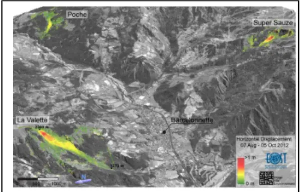
Fig. 3 The four main landslides monitored by OMIV in the
Fig. 4 Ubaye valley and major landslides around the city of
Barcelonnette (French Southern Alps): Poche, Super Sauze and La Valette landslides (Stumpf et al. 2014).
The four studied landslides are located on Figure 3 and are: (1) the Avignonet landslide (30 km South of Grenoble) and the Super-Sauze landslide (5 km South to Barcelonnette) which are soft-rock slides developed in clays; (2) the La Clapière (100 km North of Nice) and the Séchilienne landslide (25 km East of Grenoble) which are typical landslides developed in hard rocks.
We will focus on the Ubaye valley located in the French Southern Alps, because this region is affected by several large and active landslides (Figure 4) and in particular the Super-Sauze landslide which is a rapidly deforming zone (0.5 cm.d-1 to few dm.d-1, Malet et al., 2005). This landslide is located on the north-facing slope of the Barcelonnette Basin. This landslide has developed in a torrential basin located in the upper part of the Sauze torrent (Figure 4).
We will also discuss some GNSS observations acquired at the La Clapière landslide in order to illustrate the performance of different processing techniques (PPP precise point positioning and DD double difference).
3 Instruments for surface displacement
monitoring
The surface displacement monitoring performed by the Strasbourg team is based on geodetic measurements such as tacheometry, GPS, LiDAR and also terrestrial optical images.
3.1 GPS and total station measurements
Permanent GPS networks are installed on or closed to the landslide (Figure 5). The requested accuracy
of the estimated planimetric and vertical coordinates has to be better than 1 cm.
Expensive GNSS receiver and antenna were classically installed on the deforming zone, but given the possible loss of the instruments, low-cost GNSS receivers have been recently installed (Figure 6, Boetzlé, 2015; Ferhat et al. 2015). The Infra-Survey company has developed the Geomon low-cost receiver which enables a precision of 1 to 3 cm. Moreover, permanent surveys of benchmarks installed at the landslide surface using automatic total stations or GNSS-RTK (Global Navigation Satellite System Real Time Kinematic) are performed regularly from a reference station outside the deforming zone (Figure 7). The requested accuracy of the estimated planimetric and vertical coordinates is 2 cm.
Fig. 5 Permanent GNSS Trimble antenna on the Super Sauze
landslide (Boetzlé, 2015).
Fig. 6 Geomon low-cost GNSS receiver and its solar panel
4 Fig. 7 Reference benchmark observed by GNSS GR10 Leica
receiver close to the Super-Sauze landslide but outside the sliding zone (Boetzlé, 2015).
3.2 LiDAR campaigns
Campaigns of airborne and terrestrial LiDAR are setup on the most active parts of the landslide to obtain distributed information on the topography. The requested accuracy of the estimated planimetric and vertical coordinates is better than 4 cm (Travelletti et al. 2014).
3.3 Terrestrial optical images
Permanent monitoring using terrestrial optical cameras and image correlation techniques are also performed in routine at the Super-Sauze landslide (Travelletti et al., 2012; Gance et al., 2014). The requested accuracy of the estimated planimetric and vertical coordinates is better 4 cm.
4 Surface displacement obtained with
geodetic and optical observations
4.1 Geomon data processing
In order to evaluate the precision of the Geomon low-cost receivers, we have installed 5 devices on the Super-Sauze landslide and one reference on a stable zone (Figure 8).
The Geomon observations were processed using the RTKLib software.
Fig. 8 Location of the five low-cost receivers (Geomon 1 to
5) at the Super-Sauze landslide. The reference and stable station is Geomon 6 outside the deforming zone (Boetzlé, 2015).
Positions of Geomon-1 to 5 are daily computed relatively to a closed reference station SAZ4 and to a more distant one BACT (~5 km, in the city of Barcelonnette) (see locations of stations in Figure 8). The Geomon-6 station should have been used as the reference station but it encountered a failure during the period of acquisition (June 18 to July 16, 2015).
Time series of baseline lengths Geomon-4 to the reference site of SAZ4 or BACT vary daily for a 1 to 2 cm in horizontal component East and North, for up to 5 cm in the vertical component (Figure 9). The increase of the scatter in the position estimated is clearly linked to the distance to the reference.
Fig. 9 Time series of relative positions of Geomon-4 referred
to the permanent GNSS station SAZ4 or BACT during June 18 to July 16, 2015. Location of Geomon-4 is indicated in Figure 8. (Boetzlé, 2015).
4.2 DD vs PPP processing at La Clapière landslide
La Clapière landslide is monitored by a set of 3 GPS antennas located on top and center of the sliding zone. A reference station named CLAP has been installed the bottom and outside of the deforming zone (Figure 10).
Historically, the positions of the moving antennas (CLP1 to 3) have been computed relative to the reference station CLAP using the GAMIT/GLOBK software. This approach used the classical Double Difference technique (DD) to eliminate most common errors at nearby sites (atmospheric and clock errors). In order to evaluate an alternative strategy of processing the data, we use the Precise Point Positioning technique (PPP) through two softwares. GINS software is developed by the GRGS/CNES (France) and the SCR-PPP is developed at the NRCAN (Canada). Moreover relative positioning using the DD technique was evaluated using RTKLib software.
As an example, Figure 11 shows the differences for the baseline CLAP-CLP2 for 2011 between PPP approaches (GINS and SCR-PPP) and the DD GAMIT/GLOBK, which serves as a reference solution. SCRS-PPP solution is really close (less than 1 cm in North or East component) to the GAMIT/GLOBK solution. Offset of 12 cm is observed with RTKLIB in the vertical component (Figure 11).
Fig. 10 Location of the GPS antennas at La Clapière
landslide. CLAP is the reference station, CLP1 to 4 are on the deforming zone.
Fig. 11 Differences for the baseline CLAP-CLP2 in 2011 for
several processing approaches (GINS-PPP, SCRS-PPP, DD-RTKLib). The differences are indicated relative to the reference solution provided by GAMIT/GLOBK software.
The GPS and GNSS observations located on the major landslides are currently reprocessed using the SCRS-PPP software. Results in terms of time series of position and baseline length variation will be provided on OMIV website: http://omiv.unistra.fr
4.3 Correlation of optical images
The kinematics of the Super-Sauze landslide is monitored by several remote terrestrial optical cameras.
Fig. 12 Overview of the Super-Sauze landslide (South French
Alps). (A) Monitoring system by terrestrial optical photography. (B) Image acquired by the monitoring system presenting the different parts of the landslide from the camera location. (C) View of the landslide morphology in the local coordinate system on a shaded relief computed with a 0.25 m resolution DEM interpolated from an airborne LiDAR survey (ALS) acquired in July 2009. The invisible areas from the camera location are indicated (Travelletti et al., 2012).
6 Fig. 13 Displacement rate amplitude (color) and direction
(arrow) in the image plane and cumulated displacements along eight profiles crossing the landslide over the period 20 May–25 June 2008. In order to highlight the displacement direction, the arrow length is normalized for each image (Travelletti et al. 2012).
This instrumentation consists in a low-cost D70 Nikon reflex digital camera installed on a concrete pillar located on a stable crest in front of the landslide at a distance of 300 m from the lower part and 900 m from the main scarp (Figures 12A, B, and C). Every four days, a series of images is acquired at 11:00, 12:00, 13:00 and 14:00 GMT in order to increase the probability of acquiring at least one image with good meteorological and illumination conditions.
4.4 Comparison of temporal Lidar DEM.
Four to five terrestrial laser scans are acquired at the Super-Sauze landslide (toe, main scarp) since 2007. The dense point clouds have been acquired with a terrestrial long-range Optech ILRIS-3D laser scanning device from the same base stations (Figure 14).
The time series are analyzed using two approaches: 1) a method of correlation of gradient images, and 2) a method of feature tracking in the
raw 3D point clouds. The estimated surface displacements are then compared with GPS surveys on reference targets. The Figure 15 presents an example of results (Travelletti et al., 2014).
Fig. 14 Schematic presentation of the projective projection
applied on the TLS point clouds with the different coordinate systems involved in the procedure (Travelletti et al. 2014).
Fig. 15 2D displacement fields obtained from the correlation
of the grey–intensity images related to the acquisition periods of (A) July–October of the years 2008 and 2009, and (B) October–May of the years 2007 and 2008. The displacement maps are draped on their corresponding grey–intensity images (Travelletti et al. 2014).
5 Conclusions
The French Landslide Observatory (OMIV -
Observatoire Multi-disciplinaire des Instabilités de Versants) is a French-research initiative clustering
five research institutes in earth sciences. The four studied landslides are studied (Avignonet, Super-Sauze, La Clapière and Séchilienne).
Super-Sauze is monitored by several techniques developed by the OMIV research group at EOST/IPGS. We are using geodetic (GPS, tacheometry), terrestrial LiDAR (TLS) and optical images to provide deformation field of the surface of the landslide.
Concerning GNSS processing technique, we evaluate the difference between DD (Double Differencing) and PPP (Precise Point Positioning). We also evaluate the RTKLib software for relative positioning.
References
Boetzlé, P. (2015). Géodésie multi-technique pour la surveillance haute fréquence de glissements de terrains,
Master of Science in Engineering Surveying and Geomatics, INSA de Strasbourg France, 87 pages.
Ferhat, G., J.-P., Malet, P., Boetzlé, P., Ulrich (2015), Evaluation of different processing strategies of Continuous GPS (CGPS) observations for landslide monitoring, European Geosciences Union General
Assembly, Vienna, Austria, 12-17 April 2015.
Gance, J., J.-P., Malet, T., Dewez, J., Travelletti (2014). Target Detection and Tracking of moving objects for characterizing landslide displacements from time-lapse terrestrial optical images. Engineering Geology, 172: 26-40.
Malet, J.-P., D. Laigle, A. Remaître, O. Maquaire (2005). Triggering conditions and mobility of debris-flows associated to complex earthflows. Geomorphology, 66(1-4): 215-235.
Stumpf, A., J.-P., Malet, P. Allemand, P., Ulrich (2014). Surface reconstruction and landslide displacement measurements with Pléiades satellite images.
International Journal of Photogrammetry and Remote-Sensing, 95: 1-12.
Travelletti, J., C., Delacourt, P. Allemand, J.-P., Malet, J., Schmittbuhl, R., Toussaint, M., Bastard (2012). Correlation of multi-temporal ground-based optical images for landslide monitoring: Application, potential and limitations, ISPRS Journal of Photogrammetry and
Remote Sensing 70, pp.39-55.
Travelletti, J., J.-P., Malet, C., Delacourt (2014). Image-based correlation of Laser scanning point cloud time series for landslide monitoring. Journal of Applied Earth