Publisher’s version / Version de l'éditeur:
Vous avez des questions? Nous pouvons vous aider. Pour communiquer directement avec un auteur, consultez la première page de la revue dans laquelle son article a été publié afin de trouver ses coordonnées. Si vous n’arrivez pas à les repérer, communiquez avec nous à PublicationsArchive-ArchivesPublications@nrc-cnrc.gc.ca.
Questions? Contact the NRC Publications Archive team at
PublicationsArchive-ArchivesPublications@nrc-cnrc.gc.ca. If you wish to email the authors directly, please see the first page of the publication for their contact information.
https://publications-cnrc.canada.ca/fra/droits
L’accès à ce site Web et l’utilisation de son contenu sont assujettis aux conditions présentées dans le site LISEZ CES CONDITIONS ATTENTIVEMENT AVANT D’UTILISER CE SITE WEB.
Technical Memorandum (National Research Council of Canada. Division of
Building Research); Issue 72-11
READ THESE TERMS AND CONDITIONS CAREFULLY BEFORE USING THIS WEBSITE. https://nrc-publications.canada.ca/eng/copyright
NRC Publications Archive Record / Notice des Archives des publications du CNRC :
https://nrc-publications.canada.ca/eng/view/object/?id=76a0fdab-a36f-458c-b676-0c64161607a5
https://publications-cnrc.canada.ca/fra/voir/objet/?id=76a0fdab-a36f-458c-b676-0c64161607a5
NRC Publications Archive
Archives des publications du CNRC
This publication could be one of several versions: author’s original, accepted manuscript or the publisher’s version. / La version de cette publication peut être l’une des suivantes : la version prépublication de l’auteur, la version acceptée du manuscrit ou la version de l’éditeur.
Access and use of this website and the material on it are subject to the Terms and Conditions set forth at
The geotechnical properties of impervious fill materials in some
Canadian dams - Les propriétés géotechniques des matériaux du
remblai imperméable de quelques barrages canadiens
The Associate Committee on Soil and Snow
Mechanics is one of about thirty special committees which
assist the National Research Council in its work.
Formed
in 1945 to deal with an urgent wartime problem involving
soil and snow, the Committee is now perfonning its intended
ta sk of co-ordinating Canadian research studies concerned
with the physical and mechanical properties of the terrain
of the Dominion.
It
does this through subcommittees on
Snow and Ice, Soil Mechanics, Muskeg and Pennafrost.
The Committee, which consists of about twenty-five Canadians
appointed as individuals and not as representatives. each for
a 3-year term, has funds available to it for making research
grants for work in its fields of interest.
Inquiries
wi
11 be
welcomed and should be addressed to: The Secretary, Associate
Committee on Soil and Snow Mechanics, c/o Division of
Building Research, National Research Council, Ottawa, Ontario.
This publication is one of a series being produced by the
Associate Committee on Soil and Snow Mechanics of the National Research
Council.
It
may therefore be reproduced, without amendment, provided
that the Division
i
s t o ld in advance and that full and due acknowledgment
of this publication is always made.
No abridgment of this report may
be published without the written authority of the Secretary of the ACSSM.
Extracts may be published for purposes of review only.
NATIONAL RESEARCH COUNCIL
CANADA
ASSOCIA TE COMMITTEE ON SOIL AND SNOW MECHANICS
CANADIAN PAPERS PRESENTED AT THE FIFTH
INTERNA TIONAL CONFERENCE ON SOIL MECHANICS
AND FOUNDATION ENGINEERING,
PARIS,
JULY 1961
TECHNICAL MEMORANDUM NO.72
OTTAWA
JANUARY 1962
PREFACE
The Fifth International Conference on Soil Mechanics
and Foundation Engineering was held in Paris, France, from 17 to
22 July 1961.
The first such conference was held in 1936 as a part
of the tercentenary celebrations of Harvard University, Cambridge,
Mass.
The incidence of war necessitated the gap of twelve years
between the first two meetings.
The second conference was held in
Rotterdam in 1948, and the third was held in Zurich in 1953.
The
fourth was held in London in 1957.
Seven Canadians were present at the Harvard rn e e
ti.ng,
This number has increased over the years and over 25 were present
at the conference in Paris.
The Associate Committee on Soil and
Snow Mechanics of the National Research Council is pleased to publish
the reprints of the eleven Canadian papers which were included in the
official proceedings.
The International Society of Soil Mechanics and Foundation
Engineering is composed of national sections.
The executive body for
the Canadian Section is the Associate Committee on Soil and Snow
Mechanics of the National Research Council.
The principal function of
the Canadian Section is to assist in the further development and
appli-cation of soil mechanics throughout Canada.
Enquiries with regard to
its work will be welcome; they may be addressed to the Secretary,
Associate Committee on Soil and Snow Mechanics, National Research
Council, Ottawa 2, Canada.
Robert F. Legget,
Chairman.
Ottawa
The Geotechnical Properties of Impervious
Some Canadian Dams
Fill Materials
6/25
.
111
Les proprietes geotechniques des materiaux du remblai impermeable de quelques barrages
canadiens
by
D.H. MACDoNALD,Geotechnical Engineer,H.
G. ACRES& CO.LTD.,Consulting Engineers, Niagara Falls, Canada,J.
de RUITER, BISH& PARTNERS LTD,The Hague, Holland, Formerly of H. G. Acres & Co. Ltd.and
T. C.KENNEY, Norwegian Geotechnical Institute, Oslo, Norway, Formerly of H. G. Acres & Co, Ltd.
Summary
Since 1945 increasing use has been made in Canada of earth-fill and rock earth-fill dams. A variety of materials have been used for impervious fill in these dams, and a comparative review of the geotechnical properties of such soils from twenty-five of these dams is included in this paper. In the selection of the dams an atte.npt has been made to illustrate the several soil types used, to include the major earth fill and rockfill dams now completed, and to provide as complete geographical coverage as possible. The collected data indicate a correlation between the types of soils generally used for impervious fill in the different parts of the country with the nature of the underlying rock and the effects of the Pleistocene glaciations. Approximate ranges of values of the important geotechnical properties, particularlyfP',for the several groups of soils are also discernible, and these may be of some assistance in the preliminary design of these types of dams.
In the years preceding 1945, few earthfill or rockfill dams were constructed in Canada, and those that had been built were of comparatively small height. Since 1945, however, increasing use has been made of these types of dams and their sizes have progressively increased. At present, the highest earthfill dam is the 200-foot high St. Mary Dam in Alberta, and the highest rockfill dam is the 317-foot high Kenney Dam in British Columbia. The trend toward greater use of these structures is continuing and the heights of several proposed dams would rank them amongst the larger of their types in the world. As dams of these types depend for their economy upon the local availability of suitable cons-truction materials, and because the impervious fill is perhaps the most important element in such dams, it is believed that a comparative review of impervious fills used throughout Canada will be of considerable interest at this time. Many of the data presented in this paper have been collected by the authors while working on the soils of a number of dam-sites throughout Canada, but, in order that the review will be typical with regard to both geography and the larger dams of the various types now being built, the collected data have been supplemented by additional information either previously published or otherwise made available to the authors.
Geological Considerations
Canada can be divided into four main physiographic and geological regions, distinguished by variations in
topo-Sommaire
Depuis 1945, au Canada, l'usage des barrages en enrochement ou en terre s'est de plus en plus repandu, Differents rnateriaux ont ete employes pour le remblai impermeable de ces barrages et cette communication comprend une revue comparative des proprietes geotechniques des sols dont on s'est servi dans vingt-cinq d'entre eux. Les barrages ant ete choisis avec intention afin d'illustrer les differents types de sols employes, d'inclure les barrages en enrochement ou en terre les plus importants qui aient ete cons-truits jusqu'a maintenant et de couvrir une etendue geographique aussi complete que possible. La compilation de ces renseignements montre une correlation entre les types de sols generalernent employes pour les remblais imperrneables dans les differentes parties du pays, et la nature de la roche du so us-sol au les effets des periodes glaciaires du Pleistocene. Les limites approximatives des valeurs des proprietes geotechniques importantes de ces dif-ferentes sortes de sols, en particulier la valeur defP'peuvent aussi en etre deduites et ces valeurs peuvent etre utiles lors des etudes prelirninaires aux projets de ces types de barrages.
graphy, rock types, and geologic structure [14]. These regions, which are shown in Fig. 1, are the Canadian Shield, the Appalachian Region, the Plains Region, and the Cor-dilleran Region. The Canadian Shield, which forms an area of approximately 1,770,000 square miles in the northern and eastern parts of the country, is a peneplained region com-prised of igneous, metamorphic, and lesser amounts of sedimentary and volcanic rocks, all of Precambrian age. At its southerly and westerly border, these Precambrian rocks dip beneath the gently folded sedimentary rocks of Paleozoic and Mesozoic age which constitute the Plains Region. The sedimentary rocks are shales, limestones, and sandstones, of considerable thickness. The largest area of the Plains Region is the Interior Plain which joins the Cor-dilleran Region whose mountainous topography was produced by several orogenies in Mesozoic and early Cenozoic times. The Cordilleran rocks consist of deformed sedimentary and volcanic rocks, intruded by immense quantities of igneous rocks.
The Appalachian Region adjoins the eastern border of the Canadian Shield and that part of the Plains Region known as the St. Lawrence Lowlands. It is a region of mountains which were created in Paleozoic times, subsequently eroded and then uplifted to form the present area of moderately low relief. The rocks are a complex assemblage of sedimentary and volcanic rocks accompanied by lesser amounts of igneous and metamorphic types.
During the Pleistocene Epoch, almost the entire area of Canada was subjected to several continental glaciations,
...
2 NORTHWEST TERRITORI E S LEGEND セ COROILLERAN REGION セ PLAINS REGION セ APPALACHIAN REGION [:=:::J CANADIAN SHIELD NOTENUMBERS AND SYMBOLS REFER TO DAMS LISTED IN TABLE I
Fig. 1 Locations of Dams in Canada With Respect to the Major Physiographic Regions. Emplacement des barrages au Canada et principales regions geographiques,
LEGEND
セ MARINE
セ LACUSTRINE CLAY
o
GLACIAL DRIFTNOTE
NUMeERS AND Sy.,eOLS REFER TO DAMS LISTED IN TA8LE I
Fig. 2 Locations of Dams in Canada With Respect to the Distribution of Dominant Surface Soil Groups. Emplacement des barrages au Canada et repartition des groupes dominants de sol de surface.
.
..
from the St. Lawrence Valley. These two soils have clay fractions ranging from 30 per cent to 60 per cent,are moderat-ely plastic, highly impermeable, and have optimum water
00' Fig. 3 20,0 GRAVEL 6.00 '0 2.00 600 SAND '00 060 .cac 5lL T
GRAIN SIZE IN MILLIMETERS
STANDAftO SIEVE SIZES 200 100 60 40
.006
Grain Size Distribution Curves for Impervious Fill Materials in Canadian Dams.
Granulornetrie des materiaux du remblai impermeable dans les barrages canadiens.
セ
I I I I I I IY
/
//
/ /
/
CA) MARINE ANO ESTUARINE CLAYS
V
->
//
セ
セ
Is) LACUSTRINE CLAYS
----
:::::=セM
s-
セ
.»>:
V--セ
V-:
/
Y
/
セ
V
セ
セlei GLACIAL TILLS - PLASTIC
I
MMMセ
セセ e . セ セ.e>:
/-
V
セセ
Oセセ
セ
/A
"L'/L'/セ
/
セ
セィ4-
W
---'
セ セaゥUNNセ
セ
V
セ セBBB (01 GLACIAL TILLS - NON-PLASTIC
.v
V
/
/
-:
-:
N T [NUMBERS FlHHItoOAMS LiSTED
IN fA8LE I
([I RESIDUAL SOILS
I I I ... z セ 40 セ 0. '0
...
z "' 40 V セ 0.セ
C 60 2'"
10 .0...
セ 40 V セ 0: w ::J c 10 2'"
'0
'0
セ -' -' .. 60 2 in 0: "' -' -' セ 60'"
80 '0 80 0: "' -' -' C 60 セ I-,Z "' 40 IV 0:"'
..
...
セ 40 V 0: "' '0.Impervious Fill Materials :
Amongst the group of soil types outlined above those that would be expected to be suitable for impervious fill because of permeability, shear strength, and placing properties, would be the well-graded and more plastic glacial tills, and to a lesser degree the marine, lacustrine, and estuarine clays. To illustrate the use which has been made of these several soil types in dam construction in Canada, data have been collected from twenty-five dams which were selected as being representative of (a) the largest earthfill and rockfill dams constructed in Canada (hydraulic-fill dams excluded). (b) the types of soil most probably available in the various regions of the country, and (c) the variations in types of soil used in Canada for impervious fill in dam construction. The pertinent data concerning these twenty-five dams and the impervious materials used in them are contained in Table 1.
The dams in Table 1 have been grouped as shown according to soil type, and it is not surprising, in view of the widespread occurrence and satisfactory properties of the glacial tills, that they have been used in eighteen of the twenty-five dams. Considerably less use has been made of the marine, estuarine, and lacustrine clays, while. residual soils would appear to have been used even less. Chin Dam in Alberta is the only one of this last type included in Table 1. Boundary Dam has been included to illustrate a rare example of an impervious fill obtained from soft siltstone and sandstone. The geotech-nical properties of the several soil types are shown in Table 1 and Figs. 3 and 4, and are briefly described below.
Group A in Table 1 contains one marine clay, Beauhar-nois No.3, and one estuarine clay, Bersimis No.2, both with the result that most of the present surface overburden deposits are glacially derived either directly or indirectly [7]. During the latest glaciation, the Laurentide ice sheet covered the entire country east of the Cordilleran Region. Itoriginated in, and moved outwards from, several centres, the two main ones being in Central Quebec and in the Northwest Territories just west of Hudson Bay. Minor centres were located in Northern New Brunswick, Newfoundland, and Baffin Island. The Laurentide ice sheet, during its period of maximum extent, abutted the Cordilleran ice sheet along a line approximately coinciding with the boundary between the Plains Region and the Cordilleran Region. The Cordil-leran ice sheet originated in the mountainous area of British Columbia and spread outwards in easterly and westerly directions. Two areas of moderate size were not covered by ice, a part of the Yukon Territory, located along the Alaska boundary, and a number of the outermost islands of the Arctic Archipelago.
During the advance and retreat of the glaciers, the bedrock surface and most of the then existing overburden, were either eroded or reworked and subsequently deposited as unsorted glacial drift and water-sorted glacial outwash deposits. Much of the country is now covered with such materials (see Fig. 2). As the glaciers waned, freshwater lakes such as the extinct Lake Agassiz in Manitoba, the extinct Lake Barlow-Ojibway in Northern Ontario-Quebec, and the immediate areas surrounding the larger present-day lakes such as the Great Lakes, were formed. Marine incursions also occurred at this time, particularly in the Hudson Bay Lowlands, and along the St. Lawrence River Valley. Marine and estuarine conditions prevailed in these areas and sedi-mentation of fine-grained soils produced the well-known marine and estuarine clays.
Because of the extensive glaciation during Pleistocene times, and the temperate climate which has since prevailed in Canada, almost no production of residual soils has occurred. Aeolian soils are also virtually non-existent.
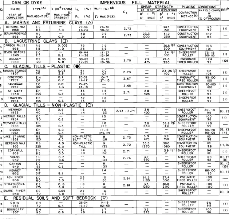
TABLE I GEOTECHN ICAl PROPERTIES OF IMPERVIOUS Fill MATERIALS IN CANADIAN DAMS
DAM OR DYKE IMPERVIOUS FILL MATERIAL
TYPEld ) k(10-6 FT./MIN LL (%) WOPT (%) td) SHEAR STRENGTH PLACING CONDITIONS REp-e)
NO. NAME AT WOPT !AT 125%OF WOP1 AV. FIELD COMpo
tbl (e) G s 4l' ( 0) 4l' ( 0) COMPACTION W
YEAR OF MAX. HYDR. METHOD(h)
COMPLETION MAX.HEIGHT(Fl) GRADIENT PL (%) YoMAX. (P.en c' (P.S.F.) c' (P.S.F.) yo
% OF PROCTOR
A. MARINE AND ESTUARINE CLAYS (b.)
I BERSIMIS1958NO.2 E C85 29-46 24-30 2.72 34.7 CONSTRUCTION 115 (I)
5.0 18-23 98-88 - 150 EQUIPMENT 97
2 BEAUHARNOIS NO.31958 RC60
-
50 29 2.73 23.3 31.2 CONSTRUCTION 107-0.9 22 91 1000 250 EQUIPMENT 98
B. LACUSTRINE CLAYS (0)
3 CARIBOU FALLS RS 0.005 79 29 - 20.5 \9/ CONSTRUCTION 103
-1958 35 1.0 25 89
-
- 200 EQUIPMENT 1014 SEVEN SISTERS E C 19-114 17 - 27
-
- 24 (f) SHEEPSFOOT 75-115 (I)1949 25 0.2 11- 38 113-94
-
300 ROLLER 90-1155 KELSEY RS 0.03 30-65 18-25 2.70 23 24.5 PNEUMATIC 124 (10)
1959 120 5.8 17- 25 110- 96 475 350 TIRED ROLLER 92
C. GLACIAL TILLS - PLASTIC (e)
6セiagara STORAGE RS 0.05 41 20 2.70 23-26 (9) SHEEPSFOOT 92 (I)
1957 68 2.8 21 104 - 100 ROLLER 105
7 CONESTOGOGQセUW EH 0.1 20-32 10-17 2.67 PNEUMATIC 95-100 (I)
104 0.7 11-17 127-113 - - TIRED ROLLER 100
8 FANSHAWE1952 EC102 0.011.3 15-2513- 18
-
-
2.65-
-
- CONSTRUCTIONEQUIPMENT 95-100 (I)100
9 ST MARY EH 35 I 5 2.71 28 - SHEEPSFOOT 94 (I)
1950 200 0.8 14 113 425 - ROLLER 95
10 TRAVE RS EC - 32 16 - - - SHEEPSFooT 93 ( I)
1954 145 0.6 15 112 -
-
ROLLER 97D. GLACIAL TILLS - NON-PLASTIC
(0)
I I MENIHEK1953 EH40 0.6 16 10 2.63 - 2.74 28
-
SHEEPSFooT 80-'.'0 (I).(2)1.2 14 132 400
-
ROLLER 9512nictaセZUZalls EC 15
-
CONSTRUCTION 100 (I)90 0.6
-
-
-
- EQUIPMENT 98I 3セeymouth FALLS EH '10
-
30 36.8 \9/ SHEEPSFOOT 110-1960 104 0.5
-
129 830 40 ROLLER 9514 SISSON EH 5.0 - 12 -18
-
- SHEEPSFOOT 80-120 I), (3)1952 85 0.4 - 123-109 -
-
ROLLER 90-105 (4)15 LAKEiセセZnne RS 30 NON- PLAST IC 8 2.73 39 39 CONSTRUCTION 101
-120 4.5 SILTY TI LL 128 475 350 EQUIPMENT 98
16 BERSIMIS NO.1 RS 4.0 NON-PLASTIC 9 2.72 35.5 38.0 CONSTRUCTION 101 (I),(121
1955 225 6.0 TILL 135 1370 1080 EQUIPMENT 98
17 CORNWALL EH 0.5 14 10 2.71 - 39 \9/ SHEEPSFOOT 96 ( I)
1958 85 0.5 10 132 - 0 ROLLER 101
18 SHAND E H 0.13
-
9 2.74 32 - SHEEPSFooT 129 (I\'11\9)1942 75 0.6
-
134 970 - ROLLER 9219 CANYON EC -
-
8-
--
SHEEPSFOOT - I), (5)1949 192 0.8
-
135 - - ROLLER - (13)20 KENNEY RS 14 - SHEEPSFOOT 86-100 (I), (8)
1952 317 8.1
-
- - - ROLLER 9521 ASH RIVER EC
-
25 10 2.91 34.5 37.4 PNEUMATIC 100-1958 80 3.0 15 135 1100 350 TIRED ROLLER 101
22 STRATHCONA ES 0.16 18 8 2.81 33 40.0 PNEUMATIC 100 (I)
1957 175 3.0 I I 141 1250 200 IRED ROLLER 100
23SNARE RIVER EC 0.04 27 16
-
-
- SHEEPSFooT - (I), (6)1948 70 1.0 18 112 -
-
ROLLER-E. RESIDUAL SOILS AND SOFT BEDROCK
('V)
24 CHI N EH - 28-34 14-19
-
- SHEEPSFOOT 90 \ I)1955 72 0.4 16-17 112-105
-
- - ROLLER 9525 BOUNDARY EH 31 17
-
32 - SHEEPSFOOT 100 (I)1957 95 0.6 19 III 575 - ROLLER 96
NOTES
4
(a) EH - EARTHFILL, HOMOGENEOUS SECTION
EC - EARTHFILL, CENTRAL CORE
ES - EARTHFILL, SLOPING CORE
RC - ROCKFILL, CENTRAL CORE
RS - ROCKFILL, SLOPING CORE
(b) MEASURE0 ABOVE ORIGINAL RIVER BED LEVEL. (e) RATIO OF SHORTEST SEEPAGE PATH TO HEAD
IN SECTION WITH MAXIMUM HEIGHT.
(d) MEASURED IN STANDARD PROCTOR TEST.
Ie) SEE REFERENCES AND ACKNOWLEDGEMENTS
AT END OF PAPER
(f) SHEAR STRENGTH PARAMETERS USED IN DESIGN.
(9) WATER CONTENT DURING TEST PROBABLY
GREATER THAN 125% OF OPTIMUM.
(h) WHERE "CONSTRUCTION EQUIPMENT" IS INDICATED
COMPACTION WAS OBTAINED BY USE OF HAULING
Significance of Impervious Fill Types in Dam Construction It is interesting to note that in eighteen of the twenty-five dams listed in Table I glacial tills were used for the impervious fill. The common occurrence of tills has undoubt-edly been a major factor in its more frequent use, but it is also probable that where a till and a clay are equally favoured by economy and availability, the till would more likely be chosen for its greater strength and possibly better placing properties. Nevertheless, it is interesting to note that the more plastic and usually weaker marine, estuarine, and lacustrine clays have been successfully used in areas where till is absent. The use of such clays is a comparatively recent development, and thus far they have only been used in core type structures of modest height. The Kelsey Dam, with a maximum height of 120 feet, is believed to be the highest structure in Canada to have a plastic clay core.
The geotechnical properties of glacial tills vary considerably, between, for instance, the moderately plastic Niagara till with ak セ 5 x 10⁻⁸ft.rmin and a (/)' セ 23 degrees to 26 de-grees, and the non-plastic Lake St. Anne till for which k ;;;;
3 X 10⁻⁵ ft./min and (/)' セ 39 degrees. The tills included in Groups C and D have been successfully used in homogeneous dams and in central and sloping core dams. In the dams greater than 150 feet in height, tills have been used exclusively. An examination of Table I reveals an interesting correlation between the type of till and the underlying rock. The plastic tills shown in Fig. 3(C), which have clay fractions ranging from 15 per cent to 25 per cent, are found in the Plains Region, an area underlain by the softer sedimentary rocks, whereas the semi-plastic and non-plastic tills shown in Fig. 3 (D), having clay fractions below 15 per cent, are found in the three physiographic regions largely underlain by the harder igneous and metamorphic rocks. The deficiency in clay-sized particles is most evident in tills from the Canadian Shield as, for example, Bersimis No. 1 and Lake St. Anne. Fig. 4 shows the value of yf1max and (/)' plotted against
W opt, with the values ofyifmax adjusted to a common value
of G.,= 2'70. Itcan be seen that the plotted values constitute a narrow band within which the several soil type groups are rather distinctly separate. Of greater interest in the design of dams, however, is the relationship between Wopt and (/)'. All values lie in a band for which the possible upper limit varies from about 45 degrees to 35 degrees as Woptincreases, and the possible lower limit similarly varies from about 25 degrees to 20 degrees. The (/)' values for the non-plastic tills and the marine and estuarine clays lie near the upper limit, whereas the values for the pas tic tills and the lacustrine clays, lie near the lower limit.
In Table 1 values have been presented, wherever possible, for the shear strength parameters, (/)' and c'; at two water content conditions. The first sets were obtained at optimum water content conditions, and in most cases they show moder-ately high values of c'. It has been customary to use these values of (/)' and c' to determine the stability at the end of construction, but because of the existence of negative pore water pressures in samples tested at about optimum water content the apparent values of (/)' and c' obtained are respect-ively lower and higher than the true values. More realistic values of these two parameters can be obtained in tests performed with water contents higher than optimum, and for this reason the second sets of shear strength data are included in Table 1. These higher values of (/)' are plotted Since the compositions of residual soils can vary widely depending on the parent rock and weathering processes, no generalizations of their properties can be made. The cases of Chin Dam and Boundary Dam are included here solely to illustrate the use of these types of soil.
0
セセ
LEGEND/}).MARINE AND ESTuARINE CLA'"
D LACUSTRINECl.AY • GLlI.CIALTILL,PlASTlC
0 GLACIALTlLL,NON.PLASTtC
0
0\
i|セ
'VRESIDUAL CLAY OR SOFT aEOROC NOT£SDENSITY "'NO ...,t,TfR CONT£NTS HAVE BEEN ADJUSTED FOl'lSP[CIFICGRAVlTY
セセ[セjセセZァァセwセセセaNィセᆪdケZセ
\
セ
b INDICATESA VALUE: CONSIDERED TO BE LOW 0セ セ
0セセLセ
0 セセ t::. 0....1"
0" ' 0 ., 'AI "O• •セ 0 '0 0POSSlBl£ LIMITS fOflSOILIS
USABLE ...S ....PEIIVfOljSFILL
--
--0 Ub0
--
MMNA[Nセ セォMM --0 'V [; 0-"
---
---1
'b --0 lOWER ll"'/T 00 NOHTESTS WERE PERfORll4EO ON FULLYOR NEARLY FULLl
'"
SATURATErSOILS
I
00" >0
Fig. 4 Wop t vs.ydm a x and <P' for Impervious Fill Materials in
Canadian Dams.
Wopt en fonction deydrc a x et <P' pour les materiaux de
remblais imperrneables dans les barrages canadiens.
OPTIMUM WATER CONTENT, PERCENT
..
,contents between 24 per cent and 30 per cent. For both clays (/)' is between 30 degrees and 35 degrees.
Three lacustrine clays, all deposits of Lake Agassiz, have been used in dam construction and are included in Group B of Table 1. The plasticity of these clays is variable because of their varved structure and differential weathering, but in general the clays are of moderate to high plasticity. They ha ve clay fractions ranging from 30 per cent to 50 per cent, very low permeability, and optimum water contents between about 20 per cent and 30 per cent. Their shear strengths are much lower than those of the Group A clays, (/)' being characteristically between 20 degrees and 25 degrees.
The eighteen glacial tills listed in Table I can be divided on the basis of grain size into two groups (see Fig. 3 (C) and (D)). Five of these tills, Group C, three from Southwestern Ontario and two from Southern Alberta, are typical of the thick clay till sheets which are underlain by sedimentary rocks. These plastic tills have clay fractions ranging from 15 per cent to 30 per cent, moderate plasticity, and low permeability. Their optimum water contents vary from 10 per cent to 20 per cent, while from the few data available (/)' might be expected to be between about 23 degrees and 30 degrees. The Group D tills have clay fractions which attain a maxi-mum of about 15 per cent, and because of the small amount of clay they exibit little or no plasticity. The permeabilities of these tills can be expected to vary rather widely between limits such as the silty Lake St. Anne till(k = 30X 10-6ft/min) and the more clayey Strathcona till(k = 0'16 x 10-6ft./min). Optimum water contents characteristically range from about 8 per cent to 15 per cent. The well-graded granular nature of these tills and their low clay contents combine to produce (/)' values which range between 35 degrees and 40 degrees.
in Fig. 4 B) and it s considered that they should be used in stability analyses together with the lower values ofc' and correct values of the pore pressure parameters.
Acknowledgements
To the following organizations which supplied data and permitted it to be published, the authors wish to extend their thanks.
H. G. Acres & Co. Ltd. (From whose files data on Dams Nos. 1, 2, 5, 7, 8, 13, 15, 16, 18, 21, and 22, were obtained.) The British Columbia Power Commission (Dams Nos. 21 and 22.)
The Grand River Conservation Commission (Dams Nos. 7 and 18.)
The Hydro-Electric Power Commission of Ontario (Dams Nos. 3, 6, and 17.)
The Manitoba Hydro-Electric Board (Dams Nos. 4 and 5). Montreal Engineering Co. Ltd. (Dams Nos. 11,19, and 23.) The New Brunswick Electric Power Commission (Dam No. 14.)
The Nova Scotia Power Commission (Dam No. 13.) The Prairie Farm Rehabilitation Administration (Dams Nos. 4, 9, 10, 24, and 25.)
The Quebec Hydro-Electric Commission (Dams Nos. 1, 2, 15, and 16.)
The Upper Thames River Conservation Authority (Dam No.8.)
The authors also wish to thank their colleagues in H. G. Acres & Co. Ltd. for their assistance in the preparation of this paper.
6
References
[1] CANADIAN ELECTRICAL ASSOCIATION, January 1958. Report on Earth and Rock-fill Dams, Hydraulic Power
Section-Eastern Zone, Hydraulic Structures Committee.
[2] CAREY, L. A. (May 1954). Menihek Power Development,
Engineering Journal, vol. 37, No.5, pp. 549-556, 563.
(3] COATES, D. F. (Dec. 1952). The Sisson Earth Dam. Proc. of
6th Canadian Soil Meek Conf., Section 7, pp. 52-59. [4] DANILIAUSKAS J. V., and COATES, D. F. (April 1953).
Compacted Earth Fill Dam for Maritime Hydro Pro-ject, Engineering Journal, vol. 36, No.4, pp. 356-361. [5] ECKENFELDER, G. V. (April 1952). Spray Hydro-Electric Power Development, Engineering Journal, vol. 35, No.4, pp. 288-304.
[6] ECKENFELDER, G. V. and RUSSELL, B. E. (March 1950). Snare River Power Project, Engineering Journal, vol. 33, No.3, pp. 165-171.
[7] FLINT, R. F. (1947). Glacial Geology and the Pleistocene Epoch, Wiley, New York, 589 pp.
(8] JOMINI, H. (Nov. 1954). The Kenney Dam, Engineering
Journal, vol. 37, No. 11, pp. 1386-1397.
[9] LEGGET, R. F. (Nov. 1942). An Engineering Study of Gla-cial Drift for an Earth Dam, Near Fergus, Ontario,
Economic Geology, vol. 37, No.7, pp. 531-556.
[10] MACDONALD, D. H., PILLMAN, R. A. and HOPPER, H. R., (Oct. 1960). Design and Construction of the Kelsey Dam and Dykes, Engineering Journal, Vol. 43, No. to,
pp. 87-98.
[11] MCQUEEN, A. W. F. and McMoRDIE, R. C. (April 1940). Soil Mechanics at the Shand Dam, Engineering Journal, vol. 23, No.4, p. 161.
[12] PATTERSON, F. W. and MACDONALD, D. H. (Aug. 1958). The Bersimis Sloping Core Dams, Proc. of A.S.C.E., Paper No. 1740.
[13] RUTLEDGE, S. (May 1950). The Spray Lakes Power Project,
Proc. of1949 Civilian Soil Mech. Conf., Tech. Mem. 17 of N.R.C., pp. 49-51.
[14] STOCKWELL, C. H. and OFFICERS OF THE GEOLOGICAL SURVEY OF CANADA (1957). Geology and Economic Minerals of Canada, Economic Geology Series No.1,
Geological Survey, Department of Mines and Technical Surveys, Ottawa, 4th Ed., 517 pp.