HAL Id: hal-01570248
https://hal.archives-ouvertes.fr/hal-01570248
Submitted on 28 Jul 2017
HAL is a multi-disciplinary open access
archive for the deposit and dissemination of
sci-entific research documents, whether they are
pub-lished or not. The documents may come from
teaching and research institutions in France or
abroad, or from public or private research centers.
L’archive ouverte pluridisciplinaire HAL, est
destinée au dépôt et à la diffusion de documents
scientifiques de niveau recherche, publiés ou non,
émanant des établissements d’enseignement et de
recherche français ou étrangers, des laboratoires
publics ou privés.
Soil quality assessment for spatial planning in urban and
periurban areas (Southern France)
Catherine Keller, Samuel Robert, Marie-Laure Lambert, Jean-Paul Ambrosi,
Eva Rabot, Stéven Criquet, Franco Ajmone-Marsan, Mattia Biasioli
To cite this version:
Catherine Keller, Samuel Robert, Marie-Laure Lambert, Jean-Paul Ambrosi, Eva Rabot, et al.. Soil
quality assessment for spatial planning in urban and periurban areas (Southern France). 4th
Interna-tional Congress of the European Confederation of Soil Science Societies (EUROSOIL 2012), Jul 2012,
Bari, Italy. �hal-01570248�
SOIL QUALITY ASSESSMENT FOR SPATIAL PLANNING IN
URBAN AND PERI-URBAN AREAS (southern France)
C. Keller
1, S. Robert
2, M.-L. Lambert
3, J-P. Ambrosi
1, Eva Rabot
4, S. Criquet
5, F. Ajmone Marsan
6, M. Biasioli
6 1. CEREGE ( ), CNRS / Aix-Marseille Université, Aix-en-Provence (F), keller@cerege.fr2. ESPACE (Etude des Structures, des Processus d'Adaptation et des Changement de l'Espace), CNRS / Aix-Marseille Université, Marseille (F) 3. CEJU-LIEU (Centre d’Etudes Juridiques en Urbanisme - Laboratoire Interdisciplinaire En Urbanisme), Aix-Marseille Université, Aix-en-Provence (F) 4. INRA, UR0272 Science du Sol, Orléans (F)
5. IMBE (Institut Méditerranéen de Biodiversité et d’Ecologie marine et continentale), Aix-Marseille Université, Marseille (F)
6. Di.VA.PRA (Dipartimento di Valorizzazione e Protezione delle Risorse Agroforestali- Chimica Agraria), Università di Torino, Grugliasco (I)
•
This experimental approach aimed at sensibilising local authorities 1) to soil functions or soil quality and its potential degradation, 2) to the advantages they could draw from a sustainable soil and land management. Feedback from the Gardanne local authorities indicate an interest in using such a tool while amending their PLU.•
The experiment highlights the need for a pluridisciplinary approach in order to propose a meaningful evaluation of soil quality of land planners.•
It allowed for a complete analysis of the French and European laws highlighting the specific status of soil as compared to air and water. Acknowledgements: GESSOL program financed by the French Ministry of Ecology, ADEME, OHM-BMP, ECCOREVFigure 1: Land use changes between 1935 and 1999 - Corine Land Cover level 1
•
Soils are considered as a major constituent of anthroposystems.•
In 2011, artificialisation reached 9% of the European territory with an increase of urban sprawl of 3% per year, larger than population increase.•
In France, the SRU law (solidarity and urban renewing law, 13th December 2000), and morerecently the “Grenelle 2” law, have pointed out the need to control urban sprawl and support reconversion and densification aiming at preserving soil quantity (surface).
•
There is no consistent either European or French legislations regarding soils management and conservation and no associated definition of soil quality.•
Soils fulfill many essential functions directly or only indirectly useful for societies such as support for agriculture, filtering of water or biodiversity tank. These functions deserve a better integration into land planning and land management procedures.To propose a methodology to integrate soil functions into land planning and land management procedures at a local scale, and apply it to the municipality of Gardanne (southern France).
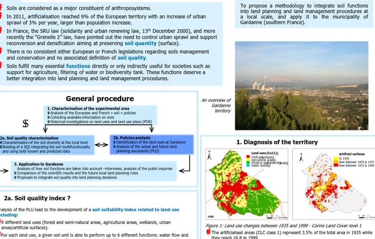
1. Diagnosis of the territory
Facts
Aim
1. Characterisation of the experimental area
oAnalysis of the European and French « soil » policies oCollecting available information on soils
oHistorical investigations on land uses and land use plans (POS)
3. Application to Gardanne
○ Analysis of how soil functions are taken into account –interviews, analysis of the public inquiries oComparison of the scientific results and the future local land planning rules
oProposals to integrate soil quality into land planning decisions
2a. Soil quality characterisation
oCharacterisation of the soil diversity at the local level oBuilding of a SQI integrating the soil multifunctionality
and using both known and predicted data
General procedure
2a. Soil quality index ?
Analysis of the PLU lead to the development of a soil suitability index related to land use including:
•
9 different land uses (forest and semi-natural areas, agricultural areas, wetlands, urban areas/artificial surfaces).•
For each land use, a given soil unit is able to perform up to 6 different functions: water flow and retention, retention and cycling of nutrients, physical stability and support, maintenance of biodiversity and habitat, buffering and filtering of potentially toxic materials and natural soil heritage. The sum of these functions represents the “multifunctionality” of the soil (Figure 2).•
For a given soil unit the sum of the satisfied functions is made first for its actual land use and then the same calculation is performed for the other land uses. The sum of results for the 9 land uses gives the land use polyvalence index which can be spatialised.•
Various alternatives have been identified to integrate information on soils into the local urban planning (PLU) documents. This could be done :- in the compulsory environmental evaluation - in the introducing report of the local plan (not binding)
- in the PADD (sustainable urban and development plan) (not binding)
•
in the specific development recommendations (binding)•
in the binding rules of each zone of the PLU (binding for each zone)•
in some reserved areas for specific activities (binding)•
in the protected woods or protected agricultural zones (binding•
in the rules for risk management: hazard maps, natural risks plans (binding)2b. Local urban planning analysis
2b. Policies analysis
oIdentification of the land uses at Gardanne oAnalysis of the actual and future land
planning documents (PLU)
•
The artificialised areas (CLC class 1) represent 3.5% of the total area in 1935 while they reach 26.8 in 1999.•
Initial agricultural areas have been consumed, mostly as the consequence of urban sprawl from the existing built-up areas.3. An original approach
Figure 2: Soil / land use suitability index - actual useUnit: Local urban planning (PLU) polygones N = natural area A = agricultural area U = urban area AU = planned as an urban area
3. Originality of the approach
Analysis of the map indicates that:
•
Assuming that natural and agricultural areas are the most demanding uses in terms of functions, some PLU areas are not matching the results of the index, indicating the limited knowledge on and/or interest in and/or weight of soil quality while building the PLU•
There is variability in soil index accuracy mostly due to limited access to the soil (private property) and an increasing soil history complexity in the urban areas Figure 3: Land use polyvalence index mapping according to the PLU polygones An overview of Gardanne territoryConclusions
Artificial surfaces In 1935New between 1935 & 1972 New between 1972 & 1999
Land uses (CLC1)
Artificial surfaces Agricultural areas Forest & semi - natural areas Water bodies