HAL Id: tel-03135109
https://tel.archives-ouvertes.fr/tel-03135109
Submitted on 8 Feb 2021HAL is a multi-disciplinary open access archive for the deposit and dissemination of sci-entific research documents, whether they are pub-lished or not. The documents may come from teaching and research institutions in France or abroad, or from public or private research centers.
L’archive ouverte pluridisciplinaire HAL, est destinée au dépôt et à la diffusion de documents scientifiques de niveau recherche, publiés ou non, émanant des établissements d’enseignement et de recherche français ou étrangers, des laboratoires publics ou privés.
in the Tibetan Plateau
Yanchuan Li
To cite this version:
Yanchuan Li. Geodetic observation and modelling of fault deformation in the Tibetan Plateau. Earth Sciences. Université Côte d’Azur, 2020. English. �NNT : 2020COAZ4002�. �tel-03135109�
1
Observation géodésique et
modélisation de la déformation des
failles dans le Plateau Tibétain
Yanchuan Li
Géoazur
Présentée en vue de l'obtention du grade de docteur en Sciences de la Terre et de l'Univers
d'Université Côte d'Azur
Dirigée par Jean-Mathieu Nocquet co-dirigée par Xinjian Shan Soutenue le 18.02.2020
Devant le jury, composé de
Cécile Lasserre, Professeur de Université de Lyon
Philippe Vernant, Professeur Agrégé au Université Montpellier II Mathilde Vergnolle, Chargée de Recherche au CNRS
Jean-Mathieu Nocquet, Directeur de Recherche IRD Xinjian Shan, Professeur de IGCEA
III
Geodetic observation and modelling of
fault deformation in the Tibetan Plateau
Thèse présentée devant le jury composé de
Rapporteurs:
Cécile Lasserre, Professeur de Université de Lyon
Philippe Vernant, Professeur Agrégé au Université Montpellier II
Examinateurs:
Mathilde Vergnolle, Chargée de Recherche au CNRS
Chunyan Qu, Professeur de Institute of Geology, China Earthquake Administration
Directeurs de these:
Jean-Mathieu Nocquet, Directeur de recherche IRD
V
Résumé
La convergence continue des plaques entre l'Inde et l'Eurasie au cours des ∼40 millions d'années a créé le plateau tibétain, une région avec une altitude moyenne de ~4500 m, une superficie de plus de 600×1000 km2, et des failles actives et une déformation crustale s'étendent sur plus de 2000 km Asie centrale. Environ la moitié des 36 à 40 mm/a de l’Inde vers le nord se répartit dans le plateau tibétain, ce qui entraîne un épaississement, un raccourcissement, des plis et des systèmes de failles complexes. La déformation crustale active provoque divers styles d'accumulation et de libération de déformation sur les failles crustales, exprimées sous la forme de comportements de failles ou de cycles sismiques distincts. L'étude de la déformation des failles crustales et des cycles sismiques sur le plateau tibétain à l'aide de la géodésie spatiale, c'est-à-dire le système de positionnement global (GPS) et l'interférométrie radar à ouverture synthétique (InSAR), a commencé il y a 30 ans. Actuellement, la géodésie à haute résolution spatio-temporelle nous fournit des données abondantes et une résolution suffisante pour étudier la déformation de la surface du sol associée aux processus du cycle sismique.
Dans cette dissertation, je me concentre sur la déformation intersismique le long de trois grands systèmes de failles de glissement du plateau tibétain, la faille Altyn Tagh, le système de failles Haiyuan et le système de failles Xianshuihe-Anninghe-Zemuhe-Xiaojiang (XAZX). J'utilise les observations géodésiques GPS (1999–2018) et InSAR (2003–2016), ainsi que les modèles de dislocations 2D et de blocs 3D, pour inverser les taux de glissement et le couplage des failles intersismiques, évaluer le risque sismique et étudier les cycles sismiques le long de ces failles; étudier en outre la cinématique de la déformation à travers le plateau tibétain. Mes résultats montrent des taux de glissement allant de ~2 à ~12 mm/a, un couplage de failles intersismiques très hétérogène (coexistant complètement verrouillé avec un fluage total), un potentiel sismique distinct et différents cycles de tremblement de terre le long de ces failles. En particulier, j'identifie deux et un nouveaux segments rampants asismiques le long du système de faille Haiyuan et de la faille Xianshuihe respectivement. Mes résultats d'observation et de modélisation géodésiques démontrent la diversité spatio-temporelle et la complexité de la déformation interstismique des failles dans le plateau tibétain, mettent en évidence l'importance de considérer la déformation verticale dans InSAR et permettent une compréhension nouvelle et approfondie des cycles sismiques le long des trois failles ci-dessus systèmes.
Mots clés: Plateau Tibétain, Déformation intersismique, Faille Altyn Tagh, Faille Haiyuan, Système de failles Xianshuihe-Xiaojiang, GPS et InSAR, Cycle sismique
VII
Abstract
Ongoing plate convergence between India and Eurasia during the past ∼40 million years has created the Tibetan Plateau, a region with average elevation of ~4500 m, area of over 600×1000 km2, and active faulting and crustal deformation extends more than 2000 km into central Asia. Approximately one-half of India’s 36–40 mm/a northward motion is partitioned in the Tibetan Plateau, resulting in crustal thickening, shortening, folds, and complex fault systems. The active crustal deformation cause diverse styles of strain accumulation and release on crustal faults, expressed as distinct faulting behavior or earthquake cycles. Investigating into crustal fault deformation and earthquake cycles in the Tibetan Plateau using space-based geodesy, i.e., Global Positioning System (GPS) and Synthetic Aperture Radar Interferometry (InSAR), has started 30 years ago. Currently, high spatial-temporal resolution geodesy provides us with abundant data and sufficient resolution to study the ground deformation associated with earthquake cycle processes.
In this dissertation, I focus on the interseismic deformation along three boundary large strike-slip fault systems of the Tibetan Plateau, the Altyn Tagh fault, the Haiyuan fault system and the Xianshuihe-Anninghe-Zemuhe-Xiaojiang fault system (XAZX). I use GPS (1999-2018) and InSAR (2003-2016) geodetic observations, along with 2D dislocation and 3D block models, to invert for slip rates and interseismic fault coupling, assess seismic hazard and investigate earthquake cycles along these faults; moreover, study the kinematics of deformation across the Tibetan Plateau. My results show slip rates ranging from ~2 to ~12 mm/a, highly heterogeneous interseismic fault coupling (fully locked coexist with fully creeping), distinct seismic potential and different earthquake cycles along these faults. In particular, I identify two and one new aseismic creeping segments along the Haiyuan fault system and the Xianshuihe fault respectively. My geodetic observation and modeling results demonstrate the spatio-temporal diversity and complexity of interseismic fault deformation in the Tibetan Plateau, highlight the significance of considering vertical deformation in InSAR, and allow a new and in-depth understanding of earthquake cycles along the above three fault systems.
Key words: Tibetan Plateau, Interseismic fault deformation, Altyn Tagh fault, Haiyuan fault, Xianshuihe-Xiaojiang fault system, GPS and InSAR, Earthquake cycle
IX
Acknowledgements/Merci
‘A journey of a thousand miles begins with a single step’. I learn the proverb or ancient poetry when I was in primary school. Although I did not fully understand the meaning behind the proverb when I was young, I was lucky to follow it on my way during the school-time in the past 24 years. I remember one night I watched a documentary about China's college entrance examination, I was deeply moved; not only for their stories, but because I was one of them. I have been from a poor rural family in China to now studying in France and receiving a PhD, which is the best reward for me and my family. On the eve of my doctoral thesis, I’d like to show my thanks to those who helped and accompanied me all the way.
First, and foremost, thanks to my supervisor Jean-Mathieu Nocquet, for receiving me to study in Geoazur, for teaching me many new things and ongoing patience in each discussion, for teaching me what qualities a scientist should have. Also, you helped me to revise my ugly manuscripts, and reminded me of the details of my works. Stay with you for the one and a half years will be one beautiful memory and the wealth of my life. I am grateful to my Chinese advisor Xinjian Shan, who not only offered me with opportunity and funding to study in France, but also supported me with everything I need in my research. Professor Shan is more like my father who gave me a lot of advice, thank you. Also, my thanks to all team colleagues in China, Chunyan Qu, Guohong Zhang, Xiaogang Song, Yunhua Liu, et al. I am happy to work with you, to work in the field, and to talk in daily lives.
I show my thanks to my friends and teachers in France, Zoe Candaux, Huihui Weng, Junchao Chen, Chen Luo, Sandrine Bertetic, Valérie Mercier-Valéro, Youling Wang, Paul Jarrin, Maria Jose Hernandez Salazar, Jenny Trevisan, Shanhong Liu, and all others who helped me and worked with me. Without you, I could not adapt to life in France so easy. My Chinese friends and colleagues, Chuanhua Zhu, Yingfeng Zhang, Dezheng Zhao, Hao Yin, Xin Qiao, Xiaodong Liu, Zicheng Huang, Shaoyan Wen, Liyan Hou, Zhishen Zhang, Pengcheng Sha, Lei Zhao, Anming Liu, Ronghu Zuo, Nana Han, Zhiyu Gao, and all others who I do not mention here, thank you for working and enjoying with me.
I am also grateful to the China Scholarship Council and China Earthquake Administration for funding me to study in France. Especially, I show my thanks to Simon Daout and his co-workers for sharing the interseismic InSAR results across the Altyn Tagh fault. I am grateful to Jiankun He, in Institute of Tibetan Plateau Research, Chinese Academy of Sciences, who shared the GPS data acquired in 2009–2011 across the western Altyn Tagh fault. I thank Cavalie Olivier for his help in revising my manuscript. I also show my gratitude to Yann Klinger for his comments on my
Xianshuihe manuscript. Moreover, the Crustal Movement Observation Network Of China (CMONOC) GPS data were provided by the National Earthquake Infrastructure Service, China Earthquake Administration, I show my thanks to all people who participated in the GPS fieldwork. Besides, Wei Zhan from the First Crust Deformation Monitoring and Application Center, China Earthquake Administration, helped me a lot with GPS data processing.
My gratitude and love to my parents and sisters. Although my family was not rich, my parents supported me and my sisters to study without any slack and complaints. We are lucky to complete our college education. Without the fully support from my parents and sisters, I may have dropped out early. I would apologize to my younger sisters for not being able to attend your weddings. I also show my love to my elder sister for taking care of our parents. My nephew and niece, I love you.
And finally to my girlfriend Huizi Jian, who is lovely, kind and considerate. She is now a PhD candidate, I hope you will also enjoy the journey. I am really happy to talk with you about our researches. It was my luck to meet you and love you. You have always encouraged me during the hardest part of my dissertation writing. Go back to the dormitory with you, eat together on weekends, watch movies, go to the gym, and go for a walk and so on, every moment will be our romantic memories. I love you.
新的旅途已经开启,愿岁月厚待,生活如花。
Yanchuan, in Nice, France December 2019
Table of Contents
Chapter 1∙
Introduction ... 1
1.1. Seismic hazard in the Tibetan Plateau ... 2
1.2. Earthquake cycle ... 6
1.2.1. Interseismic deformation ... 7
1.2.2. Coseismic deformation ... 9
1.2.3. Postseismic deformation ... 10
1.3. Previous geodetic observation and modelling of crustal deformation in the Tibetan Plateau ... 12
1.4. The aims of this thesis ... 18
1.5. References ... 19
Chapter 2∙
Geodetic datasets and data processing ... 28
2.1. GPS measurements and data processing ... 29
2.1.1. GPS measurement ... 29
2.1.2. GPS data processing ... 31
2.2. InSAR dataset ... 35
2.2.1. The Altyn Tagh fault... 35
2.2.2. The Haiyuan fault ... 35
2.2.3. The Xianshuihe fault ... 36
2.3. Geodetic data integration ... 38
2.3.1. How to consider vertical deformation ... 38
2.3.2. Methodology and data integration ... 39
2.3.3. Minor comments ... 44
2.4. References ... 45
Chapter 3∙
Measuring the crustal deformation along the Altyn Tagh fault using
GPS and InSAR... 48
3.1. Abstract ... 67
3.2. Introduction ... 68
3.3. Geodetic data and analysis ... 69
3.3.1. GPS measurements and data processing ... 69
3.3.2. Comparison of GPS and InSAR ... 71
3.4. Results ... 72
3.4.1. GPS velocity field ... 72
3.4.2. Corrections of the geodetic data for block-rotation ... 73
XIII
3.5. Discussion ... 77
3.5.1. Slow strain accumulation rate along the western Altyn Tagh fault ... 77
3.5.2. Do asymmetric patterns of interseismic velocity exist across the western Altyn Tagh fault? ... 77
3.5.3. High spatial resolution crustal deformation in the northwestern Tibet ... 79
3.6. Conclusions ... 82
3.7. References ... 83
Chapter 4∙
Surface creep on the Haiyuan fault system, northeastern Tibet,
constrained from GPS and InSAR ... 87
4.1. Abstract ... 88
4.2. Introduction ... 89
4.3. Geodetic data... 93
4.3.1. GPS data and processing ... 93
4.3.2. InSAR data ... 94
4.3.3. Geodetic data comparison and combination ... 95
4.4. Modeling strategy ... 98
4.4.1. Interseismic horizontal GPS velocities ... 98
4.4.2. Combined GPS-InSAR inversion... 98
4.5. Results ... 100
4.5.1. GPS velocity profile fitting ... 100
4.5.2. Fault creep from the restored InSAR ... 101
4.5.3. Block modeling of the GPS and restored InSAR ... 101
4.6. Discussions... 103
4.6.1. Shallow creep segments along the Laohushan fault ... 103
4.6.2. Mechanism of shallow fault creep along the Laohushan fault ... 103
4.6.3. The correlation between fault creep and the M~8 1920 Haiyuan earthquake ... 104
4.6.4. Earthquake scenarios along the Haiyuan fault system ... 106
4.7. Conclusions ... 108
4.8. References ... 109
Chapter 5∙
Heterogeneous interseismic coupling along the Xianshuihe-Xiaojiang
fault system, eastern Tibet ... 115
5.1. Abstract ... 116
5.2. Introduction ... 117
5.3. Data and model ... 119
5.3.1. GPS data processing ... 119
5.3.2. GPS data modeling ... 120
5.3.3. InSAR data and processing ... 121
5.4. Interseismic coupling results ... 123
5.5. Discussion ... 125
5.5.1. Fault behavior and moment budget along the XXFS ... 125
5.5.1.1. Overall characteristics ... 125
5.5.1.3. Southern Xianshuihe fault ... 128
5.5.1.3. Anninghe-Zemuhe fault... 130
5.5.1.4. Xiaojiang fault ... 131
5.5.1.5. Seismic potential along XXFS ... 131
5.5.2. Shallow creep along the Xianshuihe fault ... 131
5.5.3. Temporal variation in creep rate along the Xianshuihe fault (~30.2°N–30.4°N) 135 5.6. Conclusions ... 138
5.7. References ... 139
Chapter 6∙
Discussions and conclusions ... 143
6.1. Fault coupling and seismic potential ... 144
6.2. What we learn about the shallow fault creep in Tibet ... 146
6.2.1. Interseismic fault creep on crustal faults in Tibet ... 146
6.2.2. Very long-term creep/afterslip on crustal faults in Tibet ... 150
6.2.3. The role of shallow creeping in seismic behavior ... 151
6.3. What we learn about the geodetic data ... 154
6.4. Future work ... 157
6.5. References ... 159
Appendix A
-
Appendix for Chapter 3 ... 163
Appendix B
-
Appendix for Chapter 4 ... 168
Chapter 1∙ Introduction
In this chapter, I first present brief introductions about the seismic hazards in the Tibetan
Plateau. In this section, I address the significance of using geodetic measurements to
study interseismic fault deformation. Subsequently, I present general introductions on
earthquake cycle, and the crustal fault deformation characters in each phase of the cycle.
Then, I summarize the geodetic observations in the Tibetan Plateau over the last 30
years, and studies of the interseismic crustal deformation in the Tibetan Plateau. In the
last, I present the aims of this dissertation, and the main contents of each chapter are
also briefly introduced.
2
1.1. Seismic hazard in the Tibetan Plateau
The Tibetan Plateau is known as the roof of the world for its extremely high altitude. The formation of the Tibetan Plateau is one of the greatest events in the earth history that started ~55 millions of years ago, with complex dynamics and kinematic processes (e.g., Tapponnier et al., 1986). It is generally interpreted as the result of long-term collision of the Indian plate and the Eurasian plate. The collision not only caused intense crustal deformation extending thousands of kilometers northward from the Himalayan mountain range to the Mongolian platform (Figure 1.1), but also had large impacts on climate, environment, and ecology of Asia (e.g., Molnar and Tapponnier, 1975; Rowley, 1996). Probing the mechanism of lithospheric deformation of Tibet has been one key question of geodynamics and tectonics. (e.g., Avouac and Tapponnier, 1993; Shen et al., 2001; Tapponnier et al., 2001; Wright et al., 2004; Thatcher, 2007; Zhang, 2013; Li et al., 2018a, 2018b).
Figure 1.1. Tectonic map of the Tibetan Plateau. Dark red lines indicate active faults (Deng et al., 2003).
During the last century, several kinematic models have been proposed to explain the crustal lithospheric deformation mechanism of the Tibetan Plateau. These models include the ‘northward underthrusting of the Indian plate beneath Tibet’ model proposed by Argand (1924), the ‘intracrustal shortening within a hot ductile Asia’ (e.g., Dewey and Burke, 1973), the ‘successive collision of small continental blocks with the leading edge of Asia’ (e.g., Chang and Cheng, 1973), the ‘lithosphere extrusion model’ (e.g., Tapponnier and Molnar, 1975), the ‘continuum model’ (e.g.,
England and Houseman, 1986, 1988), the ‘subduction of Asian lithospheric mantle beneath Tibet’ (e.g., Willett and Beaumont, 1994), the ‘mantle diapir model’ (Xu et al., 1996), the ‘south underthrusting plus north melting’ (Owens and Zandt, 1997), and the ‘eastward flow of a channel of viscous crustal rocks’ (e.g., Royden et al., 1997; Clark and Royden, 2000). Among them, two end-number models, i.e., the ‘lithosphere extrusion model’ and the ‘continuum model’, has become a matter of debates. The ‘lithosphere extrusion model’ proposes the India-Eurasia collision to be accommodated laterally along large-scale narrow bounding fault zones by lithosphere extrusion (e.g., Tapponnier and Molnar, 1975; Meade, 2007), whereas the ‘continuum model’ stresses that the collision is partitioned by numerous, isolated fault structures, that is, the deformation is continuous throughout the entire lithosphere and dominated by broadly distributed crustal shortening and thickening (e.g., England and Houseman, 1986, 1988; Shen et al., 2001). Regardless of the deformation model of the Tibetan Plateau, one thing is certain: the active deformation has resulted in the occurrence of large crustal earthquakes inside and around the Tibet (Figure 1.2). Thus, understanding the faulting behaviors of crustal faults in Tibet are not only crucial for unraveling the mechanisms driving deformation, but also to provide insights into earthquake physics, seismic potential and hazards.
Figure 1.2. Large earthquakes (M7+, 1900-2019) in and around mainland China. Circles are
coloured by earthquake magnitude. Earthquake data from U.S. Geological Survey (USGS).
The classical view of earthquake faulting portrays large earthquakes as sudden slip events that dynamically propagate along a fault, releasing years of accumulated strain (e.g., Davison, 1901; Reid, 1910, 1911). In Tibet, the subduction of the Indian plate under the Eurasian plate results in different movement of rigid or deforming blocks, which in turn lead to strain accumulation along bounding faults, leading to a variety of faulting style (e.g., Zhang et al., 2004). Since earthquakes have started to be recorded several centuries ago, as many as 18 large earthquakes with magnitude
4
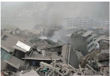
estimated larger than 8.0 and more than 100 earthquakes with magnitudes in 7.0-8.0 have been documented in and around the Tibet (Deng et al., 2016). As a result, China is the country with the highest recorded large continental earthquakes (Zhang et al., 2002). Figure 1.2 shows the large earthquakes (M7+) in the China mainland during the last century. Almost all continental earthquakes occurred in and around Tibet. Some of them have been very destructive. The 1920 Haiyuan M 8.3 earthquake caused 237,114 casualties, produced a surface rupture length of 220 km, and a maximum displacement of 10 m (e.g., Deng et al., 1986; Zhang et al., 1987); the 2008 Wenchuan Mw 7.9 earthquake had a total surface rupture length of 312 km along the Longmenshan fault zone, with maximum vertical and horizontal offsets of 6.5 m and 4.9 m respectively. It caused the destruction of buildings and the death of more than 80,000 people (e.g., Xu et al., 2009; Zhang, 2013; Figure 1.3). The frequent occurrence of destructive earthquakes inside and around Tibet calls for investigating the physical mechanisms behind earthquakes to better anticipate them.
Figure 1.3. Beichuan County, Sichuan Province, China. Picture taken about half an hour after the Mw
7.9 2008 Wenchuan earthquake, from Zhang (2013).
In the recent years, seismic potential assessment in Tibet benefited from various disciplines, such as paleoearthquake research (e.g., Liu-Zeng et al., 2007; Wen et al., 2008; Li et al., 2009; Yao et al., 2019), geomorphology (e.g., Gaudemer et al., 1995; Kirby et al., 2008), numerical simulations (e.g., Toda et al., 2008; Xiong et al., 2010; Li et al., 2014), crustal structure imaging (e.g., Wang et al., 2015), geodetic study (e.g., Cavalié et al., 2008; Shen et al., 2009; Jolivet et al., 2012, 2013, 2015a; Daout et al., 2016; Li et al., 2017, 2018a, 2018b, 2019; Rui and Stamps, 2019a). Despite fundamental differences in data and methods, most studies agree that several crustal faults inside and around the Tibet show a high potential of rupture in the near future, such as the ‘Tianzhu seismic gap’ along the Haiyuan fault, the Altyn Tagh fault, the eastern Kunlun fault and the Anninghe-Zemuhe fault system (seismotectonic settings for each of these faults are present in the following chapters; Figure 1.1). As an example, Figure 1.4 shows the logarithm of the tectonic forecast of seismicity, which was calculated from geodetic strain rates and reveals the seismic potential in one
region, of mainland China and its surroundings at large scale (Rui and Stamps, 2019b). The Himalaya, the Xianshuihe-Xiaojiang fault system, the eastern Kunlun fault system, and the western Tien Shan are the regions showing the highest forecasted seismicity rate. I recommend readers to Rui and Stamps (2019b) for more details of the calculation method.
Figure 1.4. Common logarithm of the tectonic forecast of seismicity in mainland China and its surroundings. Update from Rui and Stamps (2019b). HYF: Haiyuan fault; XAZX: Xianshuihe-Anninghe-Zemuhe-Xiaojiang fault system; KLF: Kunlun fault; LMSF: Longmenshan fault; MHT: Main Himalayan Thrust.
As one developing technology, modern geodetic measurements, i.e., Global Positioning System (GPS) and Synthetic Aperture Radar Interferometry (InSAR), reveal that slip along crustal faults is composed of aseismic and seismic slip (e.g., Bürgmann et al., 2000; Kaneko et al., 2013; Jolivet et al., 2015b; Stevens and Avouac, 2015). At depths greater than about 30-40 km, steady aseismic slip becomes dominant, whereas great continental earthquakes result from rupture of heterogeneous patches or asperities at shallower depths. In order for elastic strain to build up and be released during large earthquakes, the fault must be wholly or partially locked during the interseismic phase so that a slip deficit accumulates. With sufficient geodetic observations, it is now possible to measure surface displacements associated with interseismic strain build up or release along continental faults in great detail, thus leading to higher resolution in identifying locked/creeping patches, characterizing their temporal evolution, providing insight into interseismic behaviors and earthquake cycle physics. These are the general issues that will be addressed in the thesis, which focuses on the Haiyuan fault system, Altyn Tagh fault and the Xianshuihe-Anninghe-Zemuhe-Xiaojiang (XAZX) fault system that bounding the Tibet (Figure 1.1).
6
1.2. Earthquake cycle
Crustal displacements have been observed since the late 1800s in Japan by geodetic leveling and coastal uplift (Nagata and Okada, 1947; Fitch and Scholz, 1971). These observations lead to recognize that earthquakes were cyclic, and that the cycle of earthquake could be divided into the interseismic, coseismic, and postseismic phases. The interseismic and coseismic phases could be quantitatively related when the concept of the elastic rebound was formulated (Reid, 1911). The theory assumes elastic rheology: tectonic movements result in a steady, slow, buildup of elastic strain within certain portions of the crust. When these strains reach the maximum supportable level, an elastic rebound (an earthquake) occurs in such a way as to release the stored strain energy, accompanied by a shear dislocation on the fault plane. The quantitative relationship is: the notion that interseismic and coseismic deformation are equal in magnitude but opposite in sign so that they cancel. The elastic rebound theory explains remarkably well the overall nature of major earthquakes. However, it has been confirmed that the strain release by actual earthquakes takes place in a variety of ways. For example, most major earthquakes are followed by aftershocks and, in most cases, by creep-like postseismic deformations. This variety results from the difference in the nature of the crust (visco-elastic of the mantle) and the stress field in the respective epicentral area. This usually be termed as postseismic deformation.
I show the conceptual cartoon of deformation in the crust and uppermost mantle in Figure 1.5a, which represents the earthquake cycle deformation along one strike-slip fault. In the following, I introduce the detailed crustal deformation in each stage of an earthquake cycle, along with typical examples of surface deformation mapped by geodetic measurements.
Figure 1.5. Crustal deformation during the earthquake cycle. (a) Conceptual cartoon of deformation
in the crust and uppermost mantle. (b) Interseismic phase. InSAR interseismic crustal velocities along the San Andreas Fault Zone (SAF), California; corresponding InSAR displacements profiles are shown. (c) Coseismic phase. The complex slip distribution of an earthquake, and the occurrence of an earthquake increases and decreases the Coulomb failure stresses on nearby faults. (d) Postseismic phase. The InSAR Light of Sight (LOS) velocity across the Kunlun fault and corresponding LOS rate profile. Figure updated from Tong et al. (2013), Elliott et al. (2016) and Zhao et al. (2018).
1.2.1. Interseismic deformation
(1) Locked faults
Interseismic refers to the time between earthquakes (Harris, 2017). Reid (1910) made the first geodetic observation of interseismic deformation across the San Andreas Fault (SAF) in the 1860s and 1880s by triangulation. Since this pioneering work, similar measurements have been made across active deformation regions worldwide using modern geodetic technology, such as GPS and InSAR (e.g., Wang et al., 2001; Wright et al., 2004).
Savage and Burford (1973) first proposed the elastic screw dislocation model (equation 1.1) to analyze the triangulation data across the SAF:
8
This approach models the fault as a buried infinite screw dislocation in homogeneous elastic half-space, where the interseismic aseismic slip occurs at a rate of V0 below a locking depth of D,
V(x) is the displacement at a perpendicular distance x from the fault trace. In this model, no transition
zone at depth is assumed, which is unphysical for strike-slip faults in nature. Nevertheless, it has been widely adopted to invert for fault slip rates and locking depths owing to its simplicity. There are geodetic data showing asymmetric patterns of interseismic velocities across strike-slip faults, which could result from varying elastic thickness (e.g., Chéry, 2008), lateral variations in the elastic strength, or a shift in the position of dislocation at depth relative to the fault trace (Le Pichon et al., 2005; He et al., 2013); modeling the asymmetry geodetic data needs more complex equation, and I will present in Chapter 3.
Savage (1983) proposed the ‘back slip’ model for strain accumulation and release at subduction zones. The model was originally motivated by the recognition that the overriding plate apparently experiences little permanent inelastic deformation on the timescales relevant to the seismic cycle (several hundred years). The back slip model accomplishes this zero net strain in the overriding plate by parameterizing interseismic fault slip as normal slip, i.e., back slip, on the same patch that also slips in the reverse sense during great earthquakes (see Savage, 1983). Along with the establishment of dislocation analytical solution (Okada, 1985), spatially variable coupling models were proposed (e.g., McCaffrey, 1995; Savage et al., 2000; Wallace et al., 2004), which characterize the interseismic fault slip on the fault plane using a unitless parameter (between 0 and 1), locking coefficient or the interseismic fault coupling. The locking coefficient is equal to the back-slip rate divided by fault loading rate. Under such a frame, both fully locked (coupled) patches and fully slipping (creeping) patches might co-exist on the same fault plane. This idea has continued to this day, and inverting for the interseismic fault coupling both along subduction zones (e.g., Nocquet et al., 2014) and continental faults (e.g., Stevens and Avouac, 2015), using GPS and InSAR, has become an important tool in assessing the seismic potential and investigating the fault physical mechanism.
(2) Aseismic slipping faults
Aseismic refers to the situation where neither earthquakes nor earthquake waves are generated. Aseismic fault slip occurs when there is gradual movement on a fault without generating seismic energy or fast-moving waves in the Earth’s crust (Harris, 2017). Both interseismic shallow fault creep and slow-slip events (SSEs) are aseismic processes.
Whereas most continental faults do appear to be interseismically locked, at least within the resolution of geodetic measurements, it was discovered more than 50 years ago (e.g., Louderback, 1942) that some continental faults at specific locations exhibit significant motion during the interseismic phase. Such phenomenon was named as shallow fault creep, and has been observed along several crustal faults, such as along the Haiyuan fault in China (e.g., Cavalié et al., 2008), the central San Andreas Fault in USA (e.g., Ryder and Bürgmann, 2008) and the North Anatolian Fault
(e.g., Cakir et al., 2005) among others. Shallow fault creep is a prominent behavior in earthquake cycle, I will present some mean observation of the process in Chapter 4 and 5.
In Figure 1.5b, I present one example to show the differences between locked and creeping segments. If the fault segment is creeping up to the surface, contrary to the locked segment that produces relatively smooth geodetic velocity gradient across the fault, fault-crossing geodetic velocity show sharp gradient or offset.
SSEs (also referred to as silent earthquakes) release strain on tectonic faults at slip rates faster than plate rates but slowly enough that seismic shaking is not generated. SSEs do not induce seismic waves but could produce surface deformation. SSEs have been measured along several subduction zones (e.g., Lowry et al., 2001; Radiguet et al., 2016; Voss et al., 2018) and the southern San Andreas Fault (e.g., Tymofyeyeva et al., 2019). SSEs often occur on adjacent regions of large earthquakes on the fault interface (Rolandone et al., 2018), which could last for weeks to months, releasing energy of similar magnitude to earthquakes. Previous studies along the Mexico subduction zone have suggested that SSEs are triggering factors for large earthquakes (e.g., Kostoglodov et al., 2003; Graham et al., 2014; Radiguet et al., 2016; Voss et al., 2018); however, there is also evidence that earthquakes can trigger SSEs (e.g., Zigone et al., 2012; Villegas-Lanza et al., 2016).
1.2.2. Coseismic deformation
Earthquakes are the result of sudden slip that dynamically propagate along a fault and release the accumulated strain during the interseismic phase (e.g., Davison, 1901; Reid, 1910, 1911). Earthquakes produce seismic waves, cause permanent displacements of the ground around the fault rupture, and induce Coulomb Failure Stress (CFS) perturbations along adjacent faults (Figure 1.5c). The seismic waves, with high resolution temporal information, for medium-large earthquakes could be recorded globally, and can be analyzed to investigate the rupture process (e.g., Ammon et al., 2005; Grandin et al., 2015). The coseismic ground static displacements could be recorded by triangulation, GPS, InSAR, Leveling and other geodetic measurements, which provide high spatial resolution. Over the last 30 years, GPS and InSAR were widely adopted to invert for the coseismic slip on the fault plane (e.g., Shen et al., 2009; Figure 1.6). To this date, despite the widely use of modern geodetic data in earthquake source inversions, it is still difficult to capture the ground deformation for medium-small earthquakes (M6-) owing to the low signal to noise ratio (Funning and Garcia, 2018). An earthquake could alter the shear and normal stress on surrounding faults, often integrated as Coulomb Failure Stress changes (ΔCFS). Positive ΔCSF could bring the fault closer to failure in the short term, thus increasing the seismic potential. Negative ΔCFS reduces the seismic hazard on the fault. Besides, the CFS is commonly used to interpret the occurrence of aftershocks and afterslips following an earthquake (e.g., Stein, 1999; Perfettini and Avouac, 2004).
10
Figure 1.6. The map of seismic events color-coded by the number of associated scientific publications (top) and list of the top 50 earthquakes with the largest number of associated publications. Figure come from http://www.isc.ac.uk/event_bibliography/overview.php.
1.2.3. Postseismic deformation
Postseismic deformation was first measured by Okada and Nagata (1953) following the 1946 Mw 8.1 Nankaido, Japan, earthquake. Postseismic deformation typically occurs in hours to years following an earthquake, and provide constraints on the rheology of the lithosphere (Figure 1.5d). Three different mechanisms have been proposed to interpret the postseismic deformation following large earthquakes: aseismic afterslip (e.g. Bürgmann et al., 2002), poroelastic rebound (e.g., Peltzer et al., 1998) and viscoelastic relaxation (e.g., Nur and Mavko, 1974). Afterslip is attributed to the interaction of a velocity-weakening region at depth (within which earthquakes nucleate) with an upper region of velocity-strengthening frictional behavior (Marone et al., 1991); that is, coseismic
stress changes drive aseismic afterslip. Commonly, afterslip decay rapidly following a large earthquake and last for days to years. Poroelastic rebound is related to coseismic pressure changes, which drive fluid flow within the upper crust; poroelastic rebound often affect regions around the fault. Viscoelastic relaxation, where coseismic stress changes imparted to the hot lower crust and upper mantle cannot be sustained and drive viscoelastic flow, could last for tens of years and to more wide spread. After a large earthquake, these different mechanisms may not always operate separately, and distinguishing between them is often difficult.
Figure 1.7. Map showing earthquakes with magnitudes larger than 6.0 occurred in and around the Tibetan Plateau in 1990-2019. Labels show the three earthquakes with significant postseismic
deformation that have been studied using GPS and/or InSAR.
Within Tibet, several earthquakes with significant postseismic deformation have been documented using GPS and/or InSAR (Figure 1.7), such as the 1997 Manyi Mw 7.6 earthquake (e.g., Ryder et al., 2007), the 2001 Kokoxili Mw 7.8 earthquake (e.g., Wen et al., 2012; Zhao et al., 2018; Liu et al., 2019), and the 2008 Wenchuan Mw 7.9 earthquake (e.g., Huang et al., 2014; Diao et al., 2018). Note that, despite these large earthquakes have occurred 10-20 years ago, the post-earthquake geodetic velocity solutions in Tibet are still be contaminated by slow ongoing postseismic deformation (Li et al., 2019).
12
1.3. Previous geodetic observation and modelling of crustal
deformation in the Tibetan Plateau
Modern geodetic measurements using GPS in Tibet date back to the early 1990s when different international research projects and institutes established several regional GPS networks for crustal deformation studies in China and neighboring regions (e.g., King et al., 1997; Bendick et al., 2000; Zhu et al., 2000; Chen et al., 2000; 2004; Wang et al., 2001). By 1999, a nationwide GPS network, the Crustal Movement Observation Network of China (CMONOC-I), had been established. The CMONOC-I network included 27 continuously operating GPS stations and 1056 campaign-mode GPS stations (Niu et al., 2005). In 2009, the Tectonic and Environmental Observation Network of Mainland China (CMONOC-II) was established, adding 233 continuous stations and 1000 campaign-mode stations to the CMONOC I network (Gan et al., 2012; Figure 1.8, 1.9). To this date, campaign-mode GPS stations have been observed regularly in 1999, 2001, 2004, 2007, 2009, 2011, 2013, 2015, 2017 and 2019, with at least four days (30 s sampling rate) of continuously record. Moreover, campaign-mode observations were undertaken in Sichuan, Ordos, North China, Sichuan, Yunnan, and the Tianshan area in 2012, 2014, and 2016.
Figure 1.8. Continuous GPS stations in mainland China (http://www.cgps.ac.cn/).
Over the last 20 years, GPS data from CMONOC has been extensively used in earthquake cycle deformation studies, including interseismic deformation (e.g., Wang et al., 2001; Zhang et al.,
2004; Gan et al., 2007; Liang et al., 2013), coseismic deformation (e.g., Shen et al., 2009; Wang et al., 2011; Jiang et al., 2014), and postseismic deformation (e.g., Diao et al., 2018; Li et al., 2019; Figure 1.7). Here in my thesis, I focus on the interseismic deformation along the Haiyuan fault system, Altyn Tagh fault and the Xianshuihe-Anninghe-Zemuhe-Xiaojiang (XAZX) fault system (Figure 1.1). In the following, I introduce only previous studies about interseismic GPS velocity field.
Figure 1.9. Campaign-mode GPS stations in mainland China (http://www.cgps.ac.cn/).
Wang et al. (2001) derived the first nationwide interseismic GPS horizontal velocity field (354 stations in total) using the GPS data measured between 1991 and 2001. The velocity map depicts the general crustal deformation of the Tibetan Plateau and provides constrains for several deformation areas or faults. At the large scale, they argued that deformation within the Tibet and its margins, the Himalaya, the Altyn Tagh, and the Qilian Shan, absorbs more than 90% of the relative motion between the Indian and Eurasian plates; internal shortening of the Tibetan plateau itself accounts for more than one-third of the total convergence. Subsequently, Zhang et al. (2004) included more GPS stations (553) with longer time span (1998-2004) and derived an enlarged interseismic GPS velocity map of Tibet. By conducting and analyzing GPS velocity profiles, they argued that the present-day tectonics in the plateau could be best described as deformation of a continuous medium, at least when averaged over distances larger than 100 km. Gan et al. (2007) updated the GPS velocity solution by including 726 GPS stations in and around the Tibetan Plateau. Although the spatial resolution of these above velocity solutions are limited compared to subsequent
14
published results (e.g., Liang et al., 2013; Ge et al., 2015; Wang et al., 2017; Zheng et al., 2017), they represent the secular interseismic crustal deformation of Tibet (Figure 1.10). As in the above velocity solutions, data of GPS stations that along the Kunlun fault, where the 2001 Kokoxili Mw 7.8 earthquake occurred, were excluded. Here, I use the ‘secular’ to refer to the velocity solution is not contaminated by postseismic deformation. After that, Liang et al. (2013), Ge et al. (2015), Wang et al. (2017) and Zheng et al. (2017) published their own GPS velocity solution of the Tibet or mainland China, however, an important factor was ignored, that is, the postseismic deformation of the 2001 Kokoxili Mw 7.8 earthquake was ignored, despite they all excluded the GPS stations (measured after the 2008 Wenchuan Mw 7.9 earthquake) in eastern Tibet (Liu et al., 2019). The readers are recommend to refer Wen et al. (2012) and Zhao et al. (2018) for detailed knowledge of postseismic deformation of the 2001 Kokoxili Mw 7.8 earthquake. Note that in Liang et al’s solution, they also derived the vertical velocity field of the Tibetan Plateau. I discuss their reliability in Chapter 4 for northeastern Tibet.
Figure 1.10. GPS velocity field of crustal motion in central Asia relative to the stable Eurasia. Figure
come from Gan et al. (2007).
With the publication of GPS velocity solutions, geodesists focused on interpreting the velocity results. Wang et al. (2001), Zhang et al. (2004), Gan et al. (2007) and Ge et al. (2015) proposed the horizontal GPS velocities could explained by the ‘continuum model’, in spite of different methods or interpretations/arguments. Meanwhile, some other geodesists argued that the horizontal GPS velocities could be modeled by (elastic) block models. For instance, Shen et al. (2005) modeled the
GPS velocities in southeastern Tibet using block models and obtained a satisfactory data fitting. They proposed that the crustal deformation of southeastern Tibet could be described by rotating blocks, bounded by crustal faults, of different scales. Subsequently, Meade and Hager (2005), Thatcher (2007), Loveless and Meade (2011) and Wang et al. (2017) developed microplate or block models for Tibet. Despite differences in the scale and number of blocks, their block model predictions agree well with observations. The debate of ‘continuum model’ and ‘block model’ is not well resolved so far. Thatcher (2007) argued that as the size of the blocks decreases and tends towards the thickness of the seismogenic layer, the block model approaches a continuum and will be indistinguishable from surface velocities.
Over the last 30 years, many studies, using interseismic GPS velocities, focused on regional areas or specific faults, such as the northeastern Tibetan Plateau (e.g., Li et al., 2017), the Altyn Tagh fault (e.g., Li et al., 2018a), and the Xianshuihe-Xiaojiang fault system (e.g., Jiang et al., 2015). To avoid repeating, I will introduce previous work of each of the fault system in the following chapters.
Table 1.1. Summary of previous InSAR Studies
Location Study Location Study
A Wright et al., 2004 M Bell et al., 2011
B Taylor and Peltzer, 2006 N Grandin et al., 2012
C Taylor and Peltzer, 2006 O Qiao et al., 2017
D Taylor and Peltzer, 2006 P Liu et al., 2011
E Lasserre et al., 2007 Q Garthwaite et al., 2013
F Lasserre et al., 2007
Jolivet et al., 2008 R
Wen et al., 2012 Zhao et al., 2018
G Elliott et al., 2008
Daout et al., 2018 S Song et al., 2019
H Cavalié et al., 2008
Daout et al., 2016 T Zhu et al., 2016
J Wang et al., 2009 U Wang et al., 2019
K Wang and Wright, 2012 V Huang et al., 2014
16
Figure 1.11. Map showing the distribution of published InSAR studies of interseismic deformation in Tibet. Grey polygons with green outlines show the spatial extent of Synthetic Aperture Radar (SAR)
data used in each study. See Table 1.1 for the citations relating to each lettered polygon.
The interseismic InSAR studies in Tibet date back to Wright et al. (2004), who used the European Remote Sensing Satellite (ERS) data spanning 1992-1999 to constraint the slip rates on the Karakoram and Altyn Tagh faults. Their results show that slip rates on the Karakoram and Altyn Tagh faults are lower than what would be expected from the extrusion model and suggest a significant amount of internal deformation in Tibet. Subsequently, Lasserre et al. (2007), Elliott et al. (2008), Jolivet et al. (2008), Wang and Wright (2012), Zhu et al. (2016), Daout et al. (2018), and Xu and Zhu. (2019) processed different sources/time-spans SAR data covering different segments of the Altyn Tagh fault, aiming at either estimating its slip rate/locking depth or investigating the strain partitioning between several crustal faults in northwestern Tibet. Also, the crustal deformation along the Haiyuan fault attracted attention of geodesists. Cavalié et al. (2008) first introduced SAR data to map the left-lateral motion along the Laohushan segment. They identified a shallow creeping section along the Laohushan segment, which was later confirmed by Jolivet et al. (2012) and further studied by Jolivet et al. (2013) and Daout et al. (2015). Other faults in Tibet have also been investigated by InSAR, such as the Xianshuihe fault (Wang et al., 2009; Liu et al., 2011) and the Main Himalayan Thrust (Grandin et al., 2012). Moreover, with the accumulation of SAR data and improvement of data processing methods, large-scaled crustal deformation monitoring using InSAR becomes now possible, as the work done by Wang et al. (2019) (Figure 1.11). Furthermore, the monitoring of postseismic deformation using InSAR has been conducted along the Manyi fault (e.g., Bell et al., 2011), Kunlun fault (e.g., Wen et al., 2012; Zhao et al., 2018) and the Longmenshan fault (Huang et al., 2014). I show in Figure 1.11 the distribution of published InSAR studies of
interseismic deformation in Tibet. Although many areas of the Tibetan Plateau have been studied using InSAR, there are still large unmapped areas, especially in the southeastern Tibet, where dense vegetation cover causes a loss of coherence.
18
1.4. The aims of this thesis
The thesis focuses on three large strike-slip faults which pose a significant seismic hazard in Tibet, the Altyn Tagh fault, the Haiyuan fault system and the XAZX fault system (Figure 1.1). These faults have slip rates ranging from 2-12 mm/a, intensive historical earthquakes, different interseismic deformation characteristics (locked and shallow creeping segments), and distinct earthquake cycles. Benefiting from the geodetic observations (GPS and InSAR) across these faults, we could investigate into the interseismic fault coupling and lateral variation of coupling along faults distance. The thesis seeks to answer the following general questions: what’s the interseismic fault coupling along these faults and the seismic potential implications? The existence and distribution of shallow aseismic creep and their temporal/spatial behaviors? What we could learn about the earthquake cycle from the present-day fault deformation? For each crustal fault I studied, I emphasize its specific scientific issues in the following chapters. I will use GPS and InSAR to measure the interseismic velocities across these faults, interpret the geodetic data in detail, model the geodetic data using both two dimensional and three dimensional kinematic models, and finally interpret the results and their implications.
The rest of this thesis is organized as follows:
Chapter 2 describes, in general, the geodetic data (GPS and InSAR) and processing methods. It presents methods for GPS and InSAR comparison and integration, and shows the GPS/InSAR integration result in northeastern Tibet.
Chapter 3 consistents of two part. The first is adapted from my paper (Li et al., 2018a), which investigates the fault coupling along the Altyn Tagh fault. The remaining describes the interseismic GPS/InSAR velocity solution across the western Altyn Tagh fault (86°E), and inverts for the slip rate and locking depth on the fault.
Chapter 4 is a paper in preparation. It describes newly identified shallow creeping along the Haiyuan fault system, presents the elastic block modeling of GPS/InSAR data around the Haiyuan fault system, and describes the interseismic fault coupling and earthquake cycle along the Haiyuan fault system.
Chapter 5 is a paper submitted to Earth and Planetary Science Letters. It describes the interseismic locking and creeping on the Xianshuihe-Xiaojiang fault system, based on GPS and InSAR. Seismic potential and earthquake cycle behavior along the fault system are also discussed.
Chapter 6 summarizes the findings of the previous chapters, discusses the implications of these findings, and explores future works.
1.5. References
Ammon, C. J., Ji, C., Thio, H. K., Robinson, D., Ni, S., Hjorleifsdottir, V., ... & Ichinose, G. (2005). Rupture process of the 2004 Sumatra-Andaman earthquake. Science, 308(5725), 1133-1139. Argand, E. (1924), La Tectonique de l'Asie, in Compte-rendu du 13e congrès Géologique
International (in French), pp. 171-372, Int. Geol. Congr., Brussels.
Avouac, J. P., & Tapponnier, P. (1993). Kinematic model of active deformation in central Asia. Geophysical Research Letters, 20(10), 895-898.
Bell, M. A., Elliott, J. R., & Parsons, B. E. (2011). Interseismic strain accumulation across the Manyi fault (Tibet) prior to the 1997 Mw 7.6 earthquake. Geophysical Research Letters, 38(24). Bendick, R., Bilham, R., Freymueller, J., Larson, K., & Yin, G. (2000). Geodetic evidence for a low
slip rate in the Altyn Tagh fault system. Nature, 404(6773), 69.
Bürgmann, R., Ergintav, S., Segall, P., Hearn, E. H., McClusky, S., Reilinger, R. E., ... & Zschau, J. (2002). Time-dependent distributed afterslip on and deep below the Izmit earthquake rupture. Bulletin of the Seismological Society of America, 92(1), 126-137.
Bürgmann, R., Schmidt, D., Nadeau, R. M., d'Alessio, M., Fielding, E., Manaker, D., ... & Murray, M. H. (2000). Earthquake potential along the northern Hayward fault, California. Science, 289(5482), 1178-1182.
Cakir, Z., Akoglu, A. M., Belabbes, S., Ergintav, S., & Meghraoui, M. (2005). Creeping along the Ismetpasa section of the North Anatolian fault (Western Turkey): Rate and extent from InSAR. Earth and Planetary Science Letters, 238(1-2), 225-234.
Cavalié, O., Lasserre, C., Doin, M. P., Peltzer, G., Sun, J., Xu, X., & Shen, Z. K. (2008). Measurement of interseismic strain across the Haiyuan fault (Gansu, China), by InSAR. Earth and Planetary Science Letters, 275(3-4), 246-257.
Chen, Q., Freymueller, J. T., Yang, Z., Xu, C., Jiang, W., Wang, Q., & Liu, J. (2004). Spatially variable extension in southern Tibet based on GPS measurements. Journal of Geophysical Research: Solid Earth, 109(B9).
Chen, Z. H., Burchfiel, B. C., Liu, Y., King, R. W., Royden, L. H., Tang, W., ... & Zhang, X. (2000). Global Positioning System measurements from eastern Tibet and their implications for India/Eurasia intercontinental deformation. Journal of Geophysical Research: Solid Earth, 105(B7), 16215-16227.
Cheng-Fa, C., & Chang, Hsi-Lan. (1973). Some tectonic features of the Mt. Jolmo Lungma area, southern Tibet, China. Scientia Sinica, 16(2), 257-265.
Chéry, J. (2008). Geodetic strain across the San Andreas Fault reflects elastic plate thickness variations (rather than fault slip rate). Earth and Planetary Science Letters, 269(3-4), 352-365. Clark, M. K., & Royden, L. H. (2000). Topographic ooze: Building the eastern margin of Tibet by
lower crustal flow. Geology, 28(8), 703-706.
Daout, S., Doin, M. P., Peltzer, G., Lasserre, C., Socquet, A., Volat, M., & Sudhaus, H. (2018). Strain partitioning and present-day fault kinematics in NW Tibet from Envisat SAR interferometry. Journal of Geophysical Research: Solid Earth, 123(3), 2462-2483.
Daout, S., Jolivet, R., Lasserre, C., Doin, M. P., Barbot, S., Tapponnier, P., ... & Sun, J. (2016). Along-strike variations of the partitioning of convergence across the Haiyuan fault system detected by InSAR. Geophysical Journal International, 205(1), 536-547.
20
Davison, C. (1901). The Great Japanese Earthquake of October 28, 1891. The Geographical Journal, 17(6), 635-655.
Deng, Q., Chen, S., Song, F., Zhu, S., Wang, Y., Zhang, W., ... & Zhang, P. (1986). Variations in the geometry and amount of slip on the Haiyuan (Nanxihaushan) fault zone, China, and the surface rupture of the 1920 Haiyuan earthquake. Earthquake Source Mechanics, Geophys. Monogr. Ser, 37, 169-182.
Deng, Q., Cheng, S., Ma, J., & Peng, D. (2014). Seismic activities and earthquake potential in the Tibetan Plateau. Chinese Journal of Geophysics, 57(5), 678-697.
Deng, Q., Zhang, P., Ran, Y., Yang, X., Min, W., & Chu, Q. (2003). Basic characteristics of active tectonics of China. Science in China Series D: Earth Sciences, 46(4), 356-372.
Dewey, J. F., & Burke, K. C. (1973). Tibetan, Variscan, and Precambrian basement reactivation: products of continental collision. The Journal of Geology, 81(6), 683-692.
Diao, F., Wang, R., Wang, Y., Xiong, X., & Walter, T. R. (2018). Fault behavior and lower crustal rheology inferred from the first seven years of postseismic GPS data after the 2008 Wenchuan earthquake. Earth and Planetary Science Letters, 495, 202-212.
Elliott, J. R., Biggs, J., Parsons, B., & Wright, T. J. (2008). InSAR slip rate determination on the Altyn Tagh Fault, northern Tibet, in the presence of topographically correlated atmospheric delays. Geophysical Research Letters, 35(12).
Elliott, J. R., Walters, R. J., & Wright, T. J. (2016). The role of space-based observation in understanding and responding to active tectonics and earthquakes. Nature Communications, 7, 13844.
England, P. C., & Houseman, G. A. (1988). The mechanics of the Tibetan Plateau. Philosophical Transactions of the Royal Society of London. Series A, Mathematical and Physical Sciences, 326(1589), 301-320.
England, P., & Houseman, G. (1986). Finite strain calculations of continental deformation: 2. Comparison with the India-Asia collision zone. Journal of Geophysical Research: Solid Earth, 91(B3), 3664-3676.
Fitch, T. J., & Scholz, C. H. (1971). Mechanism of underthrusting in southwest Japan: A model of convergent plate interactions. Journal of Geophysical Research, 76(29), 7260-7292.
Funning, G. J., & Garcia, A. (2018). A systematic study of earthquake detectability using Sentinel-1 Interferometric Wide-Swath data. Geophysical Journal International, 2Sentinel-16(Sentinel-1), 332-349. Gan, W., Li, Q., Zhang, R., & Shi, H. B. (2012). Construction and application of tectonics and
environmental observation network of mainland China. J. Eng. Stud, 4(4), 324-331.
Gan, W., Zhang, P., Shen, Z. K., Niu, Z., Wang, M., Wan, Y., ... & Cheng, J. (2007). Present-day crustal motion within the Tibetan Plateau inferred from GPS measurements. Journal of Geophysical Research: Solid Earth, 112(B8).
Gaudemer, Y., Tapponnier, P., Meyer, B., Peltzer, G., Shunmin, G., Zhitai, C., ... & Cifuentes, I. (1995). Partitioning of crustal slip between linked, active faults in the eastern Qilian Shan, and evidence for a major seismic gap, the ‘Tianzhu gap’, on the western Haiyuan Fault, Gansu (China). Geophysical Journal International, 120(3), 599-645.
Ge, W. P., Molnar, P., Shen, Z. K., & Li, Q. (2015). Present-day crustal thinning in the southern and northern Tibetan plateau revealed by GPS measurements. Geophysical Research Letters, 42(13), 5227-5235.
Salazar-Tlaczani, L. (2014). GPS constraints on the 2011–2012 Oaxaca slow slip event that preceded the 2012 March 20 Ometepec earthquake, southern Mexico. Geophysical Journal International, 197(3), 1593-1607.
Grandin, R., Doin, M. P., Bollinger, L., Pinel-Puysségur, B., Ducret, G., Jolivet, R., & Sapkota, S. N. (2012). Long-term growth of the Himalaya inferred from interseismic InSAR measurement. Geology, 40(12), 1059-1062.
Grandin, R., Vallée, M., Satriano, C., Lacassin, R., Klinger, Y., Simoes, M., & Bollinger, L. (2015). Rupture process of the Mw= 7.9 2015 Gorkha earthquake (Nepal): Insights into Himalayan megathrust segmentation. Geophysical Research Letters, 42(20), 8373-8382.
Harris, R. A. (2017). Large earthquakes and creeping faults. Reviews of Geophysics, 55(1), 169-198.
He, J., Vernant, P., Chéry, J., Wang, W., Lu, S., Ku, W., ... & Bilham, R. (2013). Nailing down the slip rate of the Altyn Tagh fault. Geophysical Research Letters, 40(20), 5382-5386.
Huang, M. H., Bürgmann, R., & Freed, A. M. (2014). Probing the lithospheric rheology across the eastern margin of the Tibetan Plateau. Earth and Planetary Science Letters, 396, 88-96. Jiang, G., Xu, X., Chen, G., Liu, Y., Fukahata, Y., Wang, H., ... & Xu, C. (2015). Geodetic imaging
of potential seismogenic asperities on the Xianshuihe-Anninghe-Zemuhe fault system, southwest China, with a new 3-D viscoelastic interseismic coupling model. Journal of Geophysical Research: Solid Earth, 120(3), 1855-1873.
Jiang, Z., Wang, M., Wang, Y., Wu, Y., Che, S., Shen, Z. K., ... & Li, Q. (2014). GPS constrained coseismic source and slip distribution of the 2013 Mw6. 6 Lushan, China, earthquake and its tectonic implications. Geophysical Research Letters, 41(2), 407-413.
Jolivet, R., Candela, T., Lasserre, C., Renard, F., Klinger, Y., & Doin, M. P. (2015a). The Burst-Like Behavior of Aseismic Slip on a Rough Fault: The Creeping Section of the Haiyuan Fault, ChinaShort Note. Bulletin of the Seismological Society of America, 105(1), 480-488.
Jolivet, R., Cattin, R., Chamot-Rooke, N., Lasserre, C., & Peltzer, G. (2008). Thin-plate modeling of interseismic deformation and asymmetry across the Altyn Tagh fault zone. Geophysical Research Letters, 35(2).
Jolivet, R., Lasserre, C., Doin, M. P., Guillaso, S., Peltzer, G., Dailu, R., ... & Xu, X. (2012). Shallow creep on the Haiyuan fault (Gansu, China) revealed by SAR interferometry. Journal of Geophysical Research: Solid Earth, 117(B6).
Jolivet, R., Lasserre, C., Doin, M. P., Peltzer, G., Avouac, J. P., Sun, J., & Dailu, R. (2013). Spatio-temporal evolution of aseismic slip along the Haiyuan fault, China: Implications for fault frictional properties. Earth and Planetary Science Letters, 377, 23-33.
Jolivet, R., Simons, M., Agram, P. S., Duputel, Z., & Shen, Z. K. (2015b). Aseismic slip and seismogenic coupling along the central San Andreas Fault. Geophysical Research Letters, 42(2), 297-306.
Kaneko, Y., Fialko, Y., Sandwell, D. T., Tong, X., & Furuya, M. (2013). Interseismic deformation and creep along the central section of the North Anatolian fault (Turkey): InSAR observations and implications for rate-and-state friction properties. Journal of Geophysical Research: Solid Earth, 118(1), 316-331.
King, R. W., Shen, F., Clark Burchfiel, B., Royden, L. H., Wang, E., Chen, Z., ... & Li, Y. (1997). Geodetic measurement of crustal motion in southwest China. Geology, 25(2), 179-182. Kirby, E., Whipple, K., & Harkins, N. (2008). Topography reveals seismic hazard. Nature
22
Geoscience, 1(8), 485.
Kostoglodov, V., Singh, S. K., Santiago, J. A., Franco, S. I., Larson, K. M., Lowry, A. R., & Bilham, R. (2003). A large silent earthquake in the Guerrero seismic gap, Mexico. Geophysical Research Letters, 30(15).
Lasserre, C., Cavalié, O., Peltzer, G., Socquet, A., Doin, M. P., Sun, J., ... & Gaudemer, Y. (2007). Interseismic strain across the Altyn Tagh and Haiyuan faults at the northern edge of the Tibetan plateau, measured by space geodesy. EGU General Assembly.
Le Pichon, X., Kreemer, C., & Chamot-Rooke, N. (2005). Asymmetry in elastic properties and the evolution of large continental strike-slip faults. Journal of Geophysical Research: Solid Earth, 110(B3).
Li, C., Zhang, P. Z., Yin, J., & Min, W. (2009). Late Quaternary left-lateral slip rate of the Haiyuan fault, northeastern margin of the Tibetan Plateau. Tectonics, 28(5).
Li, Y., Jia, D., Wang, M., Shaw, J. H., He, J., Lin, A., ... & Rao, G. (2014). Structural geometry of the source region for the 2013 Mw 6.6 Lushan earthquake: Implication for earthquake hazard assessment along the Longmen Shan. Earth and Planetary Science Letters, 390, 275-286. Li, Y., Shan, X., & Qu, C. (2019). Geodetic Constraints on the Crustal Deformation along the
Kunlun Fault and Its Tectonic Implications. Remote Sensing, 11(15), 1775.
Li, Y., Shan, X., Qu, C., Liu, Y., & Han, N. (2018a). Crustal deformation of the Altyn Tagh fault based on GPS. Journal of Geophysical Research: Solid Earth, 123(11), 10309-10322.
Li, Y., Shan, X., Qu, C., Zhang, Y., Song, X., Jiang, Y., ... & Wang, C. (2017). Elastic block and strain modeling of GPS data around the Haiyuan-Liupanshan fault, northeastern Tibetan Plateau. Journal of Asian Earth Sciences, 150, 87-97.
Li, Y., Zhang, G., Shan, X., Liu, Y., Wu, Y., Liang, H., ... & Song, X. (2018b). GPS-derived fault coupling of the Longmenshan fault associated with the 2008 Mw Wenchuan 7.9 earthquake and its tectonic implications. Remote Sensing, 10(5), 753.
Liang, S., Gan, W., Shen, C., Xiao, G., Liu, J., Chen, W., ... & Zhou, D. (2013). Three-dimensional velocity field of present-day crustal motion of the Tibetan Plateau derived from GPS measurements. Journal of Geophysical Research: Solid Earth, 118(10), 5722-5732.
Liu, S., Xu, X., Klinger, Y., Nocquet, J.-M., Chen, G., Yu, G., & Jónsson, S. (2019). Lower crustal heterogeneity beneath the northern Tibetan Plateau constrained by GPS measurements following the 2001 Mw 7.8 Kokoxili earthquake. Journal of Geophysical Research: Solid Earth, 124.
Liu, Y., Xu, C., Li, Z., Wen, Y., & Forrest, D. (2011). Interseismic slip rate of the Garze–Yushu fault belt in the Tibetan Plateau from C-band InSAR observations between 2003 and 2010. Advances in Space Research, 48(12), 2005-2015.
Liu-Zeng, J., Klinger, Y., Xu, X., Lasserre, C., Chen, G., Chen, W., ... & Zhang, B. (2007). Millennial recurrence of large earthquakes on the Haiyuan fault near Songshan, Gansu Province, China. Bulletin of the Seismological Society of America, 97(1B), 14-34.
Louderback, G. D. (1942). Faults and earthquakes. Bulletin of the Seismological Society of America, 32(4), 305-330.
Loveless, J. P., & Meade, B. J. (2011). Partitioning of localized and diffuse deformation in the Tibetan Plateau from joint inversions of geologic and geodetic observations. Earth and Planetary Science Letters, 303(1-2), 11-24.
southern Mexico. Geophysical Research Letters, 28(19), 3753-3756.
Marone, C. J., Scholtz, C. H., & Bilham, R. (1991). On the mechanics of earthquake afterslip. Journal of Geophysical Research: Solid Earth, 96(B5), 8441-8452.
McCaffrey, R. (1995). DEFNODE users guide. Rensselaer Polytechnic Institute, Troy, New York. Meade, B. J. (2007). Present-day kinematics at the India-Asia collision zone. Geology, 35(1),
81-84.
Meade, B. J., & Hager, B. H. (2005). Block models of crustal motion in southern California constrained by GPS measurements. Journal of Geophysical Research: Solid Earth, 110(B3). Molnar, P., & Tapponnier, P. (1975). Cenozoic tectonics of Asia: effects of a continental collision.
Science, 189(4201), 419-426.
Nagata,T., and A. Okada (1947). Land deformation of the Muroto Point before and after the Nankai great earthquake on December 21, 1946. Bull. Earthq. Res. Inst. 25, 85-89.
Niu, Z., Min, W., Hanrong, S., Jianzhong, S., Xinzhao, Y., Weijun, G., ... & Yongxiang, W. (2005). Contemporary velocity field of crustal movement of Chinese mainland from Global Positioning System measurements. Chinese Science Bulletin, 50(9), 939-941.
Nocquet, J. M., Villegas-Lanza, J. C., Chlieh, M., Mothes, P. A., Rolandone, F., Jarrin, P., ... & Martin, X. (2014). Motion of continental slivers and creeping subduction in the northern Andes. Nature Geoscience, 7(4), 287.
Nur, A., & Mavko, G. (1974). Postseismic viscoelastic rebound. Science, 183(4121), 204-206. Okada, A., and T. Nagata (1953), Land deformation of the neighborhood of Muroto Point after the
Nankaido great earthquake in 1946. Bull. Earthquake Res. Inst. Univ. Tokyo, 31, 169-177. Okada, Y. (1985). Surface deformation due to shear and tensile faults in a half-space. Bulletin of the
Seismological Society of America, 75(4), 1135-1154.
Owens, T. J., & Zandt, G. (1997). Implications of crustal property variations for models of Tibetan plateau evolution. Nature, 387(6628), 37.
Peltzer, G., Rosen, P., Rogez, F., & Hudnut, K. (1998). Poroelastic rebound along the Landers 1992 earthquake surface rupture. Journal of Geophysical Research: Solid Earth, 103(B12), 30131-30145.
Perfettini, H., & Avouac, J. P. (2004). Postseismic relaxation driven by brittle creep: A possible mechanism to reconcile geodetic measurements and the decay rate of aftershocks, application to the Chi-Chi earthquake, Taiwan. Journal of Geophysical Research: Solid Earth, 109(B2). Qiao, X., Yu, P., Nie, Z., Li, J., Wang, X., Kuzikov, S. I., ... & Yang, S. (2017). The crustal
deformation revealed by GPS and InSAR in the northwest corner of the Tarim Basin, northwestern China. Pure and Applied Geophysics, 174(3), 1405-1423.
Radiguet, M., Perfettini, H., Cotte, N., Gualandi, A., Valette, B., Kostoglodov, V., ... & Campillo, M. (2016). Triggering of the 2014 M w 7.3 Papanoa earthquake by a slow slip event in Guerrero, Mexico. Nature Geoscience, 9(11), 829.
Reid, H. F. (1910). On mass movements in tectonic earthquakes and the depth of the focus. Beitragen Geophys., 10, 318–351.
Reid, H. F. (1911). The elastic-rebound theory of earthquakes. Univ. Calif. Publ. Bull. Dept. Geol., 6(19), 413-444.
Rolandone, F., Nocquet, J. M., Mothes, P. A., Jarrin, P., Vallée, M., Cubas, N., ... & Font, Y. (2018). Areas prone to slow slip events impede earthquake rupture propagation and promote afterslip. Science Advances, 4(1), eaao6596.