HAL Id: ird-01223163
https://hal.ird.fr/ird-01223163
Submitted on 2 Nov 2015
HAL is a multi-disciplinary open access
archive for the deposit and dissemination of sci-entific research documents, whether they are pub-lished or not. The documents may come from teaching and research institutions in France or abroad, or from public or private research centers.
L’archive ouverte pluridisciplinaire HAL, est destinée au dépôt et à la diffusion de documents scientifiques de niveau recherche, publiés ou non, émanant des établissements d’enseignement et de recherche français ou étrangers, des laboratoires publics ou privés.
Glacier shrinkage in the Andes and consequences for
water resources-Editorial
Anne Coudrain, Bernard Francou, Zbignew W. Kundzewicz
To cite this version:
Anne Coudrain, Bernard Francou, Zbignew W. Kundzewicz. Glacier shrinkage in the Andes and consequences for water resources-Editorial. Hydrological Sciences Journal, Taylor & Francis, 2005. �ird-01223163�
Publié dans Hydrological Sciences Journal = Journal Des Sciences Hydrologiques, 2005, 50
(6), p. 925-932. ISSN 0262-6667 - doi:10.1623/hysj.2005.50.6.925
Glacier shrinkage in the Andes and consequences for
water resources—Editorial
ANNE COUDRAIN1, BERNARD FRANCOU2 & ZBIGNIEW W. KUNDZEWICZ3,4
1 Institut de Recherche pour le Développement, Unité de Recherche Great Ice UR32,
Case MSE (UMII – IRD – CNRS), BP 64501, F-34394 Montpellier Cedex 5, France coudrain@ird.fr
2 Institut de Recherche pour le Développement, Unité de Recherche Great Ice UR32, CP 9214 La Paz, Bolivia
bfrancou@acelerate.com
3 Research Centre of Agricultural and Forest Environment, Polish Academy of Sciences, Bukowska 19, 60-809 Poznań, Poland
zkundze@man.poznan.pl
4 Potsdam Institute for Climate Impact Research, D-14412 Potsdam, Germany
INTRODUCTION
The state of mountain glaciers is a good climatic indicator of the global warming of the planet—one of most spectacular, and persuasive, manifestations of climate change. Numerous studies worldwide show a widespread, and well documented, retreat of mountain glaciers in non-polar regions of the world during the 20th century (IPCC, 2001). In fact, many glaciers have been shrinking for even longer, since the temperature minima of the Little Ice Age (17th–19th centuries), but a clear acceleration of the glacier retreat has been observed during recent decades. Glacier retreat is an un-deniable fact and poses several questions: what is the reason for it and what are the observed and projected impacts? The likely reason is climate change and the primary impacts refer to glacier-based water resources and systems dependent on them. The glacier changes reflect mainly accumulated changes in temperature and precipitation. The relationship between glacier and temperature may depend on a number of factors, such as the geometry of the glacier and its surroundings, glacier area and depth, and those controlling the heat fluxes (summertime cloudiness, albedo, humidity, wind). On the global scale, air temperature is considered to be the most important factor controlling glacier retreat. For a typical mid-latitude glacier, a 1°C temperature rise would have the same effect as much greater decreases in cloudiness (by 30%) or precipitation (by 25%) (IPCC, 2001). In several areas, the climatic anomalies have been strongly influenced by the El Niño-Southern Oscillation (ENSO) events. The warm (El Niño) phase of ENSO, influencing the phase of precipitation at the altitudes of the glacier accumulation zone (for the Andes, see Francou et al., 2004), has become more intense, more frequent, and more long-lasting in recent decades (IPCC, 2001).
Even if the general picture is of a widespread, and long-lasting, retreat of mountain glaciers, in a few regions glaciers were advancing, until a few years ago. In Norway, many coastal glaciers advanced in the 1990s due to precipitation enhancement related to the more pronounced positive phase of the North Atlantic Oscillation (NAO), but in the last four years, with very warm summers, glacier shrinkage has been observed.
Studies of the shrinkage of mountain glaciers have considerable potential to support or qualify the temperature records (IPCC, 2001). Climate-relevant glacier data, such as measurements of the terms of the surface energy balance, and measurements or reconstruction of the mass balance (gain or loss of ice mass) and of the geometry (area and length) of glaciers, complement the instrumental meteorological records. They are particularly valuable, as some of them extend back in time (to before the instrumental era) and some are from remote, inaccessible, data-scarce regions. Typically, glaciers exist at a significantly higher altitude than meteorological stations.
Tropical and sub-tropical areas are of particular concern. This is where most of the world’s people live and where the wealth of global biodiversity is located. Unprecedented retreat of old glaciers in the tropics and sub-tropics has been observed and projections are made of complete disappearance of small glaciers. The iconic sites, such as Kilimanjaro, which was immortalized in Hemingway’s novel ―The Snows of Kilimanjaro‖, and Chacaltaya (Bolivia), which was the highest skiing station, may disappear completely in the near future.
Relating fluctuations in glacier mass balance to meteorological conditions is more complicated for tropical glaciers than for mid- and high-latitude mountain glaciers, since the most important factors may be those that drive the albedo and not the local temperature (Sicart et al., 2003). Nevertheless, the fast glacier recession in the tropics appears to be consistent with an upward shift of the equilibrium line (where glacier accumulation balances with ablation) and of the 0°C isotherm.
ANDEAN GLACIERS
In contrast to the Alpine glaciers, which undergo a long accumulation period in winter and a short ablation season in summer, the glaciers of the tropical Andes experience, in their lower part, an ablation regime throughout the year. Melting is at its height in Bolivia and Peru during the austral summer (October–April) when the strongest radiation input coincides with the maximum rainfall, and in Ecuador in the months nearer to the equinoxes (April–May and September). Tropical Andean glaciers have a seasonal precipitation distribution (dry and wet season), while seasonal temperature variations are small, compared to strong diurnal (day–night) amplitude.
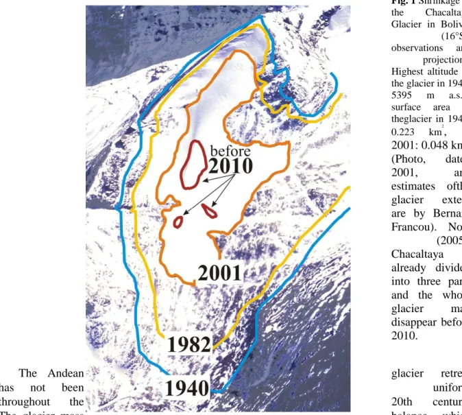
There is growing evidence that the observed general glacier retreat in the warming tropical Andes has accelerated significantly in the last decades. The retreat includes even large glaciers, but it is particularly dramatic for the small-sized glaciers, such as the Chacaltaya Glacier in Bolivia (16°S), whose present area (2005) is less than
0.04 km2. The Chacaltaya Glacier may disappear before 2010 (see Fig. 1). Along the length of the Andes, glacier retreats have been dominating and (minor) advances of glacier snouts have been exceptional. Data suggest that changes in precipitation and cloud cover in the latter part of the 20th century were minor, and that changes in these quantities are unlikely to explain the ubiquitous Andean glacier retreat. The general shrinkage of glaciers is driven by temperature rise at high elevation in the southern Andes. However, the processes are more complex in the tropics, where the increase in melting reflects a complex combination of factors related to the energy balance, such as temperature, duration of dry events, precipitation and humidity which control albedo, and melting/sublimation.
Fig. 1 Shrinkage of the Chacaltaya Glacier in Bolivia (16°S): observations and projections. Highest altitude of the glacier in 1940: 5395 m a.s.l.; surface area of theglacier in 1940: 0.223 km2, in 2001: 0.048 km2. (Photo, dated 2001, and estimates ofthe glacier extent are by Bernard Francou). Now (2005), Chacaltaya is already divided into three parts and the whole glacier may disappear before 2010.
The Andean glacier retreat
has not been uniform
throughout the 20th century.
The glacier mass balance, which
is an estimate of the difference between the accumulation of snow and ice and their ablation (by melting and sublimation), appears to be strongly controlled by the climate variability at decadal time scales, driven by the ENSO mechanism. During the warm (El Niño) period, negative mass balances are observed in the tropical areas, linked to a deficit of precipitation during the summer/wet period in Bolivia and during February–May in Ecuador, which directly affects the albedo and the melting rates at the glacier surface. In this intense melting period, the snow/rain limit moves up to 5000 m, which results in decreased accumulation. Positive anomalies of mass balance are also documented during the warm (El Niño) period but generally occur on glaciers located in sub-tropical areas (30–35°S), due to enhanced winter precipitation. During an El Niño year, intertropical glaciers may lose from 600 to 1200 mm of water equivalent. The opposite occurs during the cooler and more humid La Niña phase, during which the glaciers return to equilibrium and sometimes show a minor increase. Warm events that have been occurring at higher frequency since the widely recognized shift in 1976, and the acceleration in the retreat of glaciers, particularly in the tropics, is seen as the consequence of the change in the Southern Oscillation regime and Pacific warming over the last 25 years. Between 1976 and 1997 the equatorial Pacific has been abnormally warm for more than 15 years, while cold conditions were more frequent during the 1956–1976 period (see http://www.cdc.noaa.gov/ENSO/enso.mei). As a consequence, the Andean glaciers showed a mass balance close to the equilibrium before 1976–1980, and a persistent negative balance thereafter.
It is important to identify the physical processes responsible for the surface melting and sublimation occurring on the glaciers. In a number of pilot studies, the energy balance of glaciers has been monitored and the amounts of energy received and absorbed by the glaciers, resulting from solar radiation and turbulent flow, were determined from meteorological data (including relative humidity, temperature, wind direction and velocity) collected at the glacier surface. The energy balance investigations show that glacier melt is governed mainly by the net radiation, which represents the fraction of incident solar radiation absorbed by the glacier. This emphasizes the essential role of the reflective properties of the glacier surface, i.e. the albedo. As noted by Sicart et al. (2003), melting of tropical glaciers strongly depends on the seasonal distribution of precipitation, due to the high albedo of (even thin) fresh snow cover.
The present Special Section of Hydrological Sciences Journal contains six papers referring to tropical and sub-tropical glaciers in four countries of South America: Bolivia, Chile, Ecuador and Peru. These are revised and updated versions of selected contributions to the Second Symposium on Mass Balance of Andean Glaciers. The symposium, organized by INRENA (Instituto Nacional de Recursos Naturales, Peru) and IRD (Institut de Recherche pour le Développement, France), was held in Huaráz (Peru) from 6 to 9 July 2004. It was co-sponsored by the International Association of Hydrological Sciences (IAHS). The main purpose of this event was to highlight the recent climatic changes occurring in the Andean Cordillera and to encourage the scientific community to strengthen the glacier observation network existing along the Andean chain from Colombia to the Patagonian ice fields. Abstracts of all the papers presented at the Huaráz Symposium and authors’ addresses are available at http://www.greatice.ird.fr.
Carrasco et al. (2005) report an overall retreat of glaciers in the Andes of central Chile during the last hundred years, probably due to changes in temperature and precipitation. An overall warming, of 1.3–2.1ºC in minimum near-surface air temperature and 0.2–1.5ºC in maximum temperature, occurred in central Chile during 1961–2001. Analysis of radiosonde temperature data for central Chile shows mid-tropospheric warming with an increase in elevation of the 0ºC isotherm of 122 ± 8 m and 200 ± 6 m in winter and summer, respectively, during 1975–2001. Precipitation data show a general decrease during the last century and a slight increase during the second half of the 20th century in a latitude range 30–34°S. This behaviour is probably due to the influence of the ENSO, which is stronger northward of 34ºS. Warming has been concentrated during periods with no precipitation, leading to enhanced melting of glaciers. The number of days with precipitation has decreased, indicating that precipitation events are becoming less frequent but more intense. This also suggests that glaciers are exposed to more days with atmospheric conditions appropriate for melting.
Carrasco et al. (2005) make projections for the end of the 21st century, which indicate that the equilibrium line altitude in central Chile (30–38ºS) may rise by about 400 m compared to its present-day location, under SRES scenario A2 (cf. IPCC, 2000). Changes in air temperature rather than precipitation are projected to be the main driving factor.
Jordan et al. (2005) used aerial photographs of the Cotopaxi Volcano ice cap (Ecuador) to quantify the evolution of the surface area. The results show that glaciers stagnated from 1956 to 1976 and then underwent a very strong recession from 1976 to 1997, losing about 30% of their surface area (probably linked to the increase in intensity, duration and frequency of warm ENSO phases). This finding corroborates the observations made on the nearby Glacier 15 (Antizana ice cap) located 10 km northeast of the Cotopaxi Volcano, which also lost about 30% of its surface area from 1956 to 1997. Slope exposure to humid fluxes from the Amazon and solar radiation at the Cotopaxi ice cap did not have any significant effect, since all the glaciers of the volcano retreated to a similar degree. It is interesting to note that the glacier recession on the Cotopaxi Volcano was particularly pronounced because of the conical form of the ice cap, resulting in exposure of the surface area below the equilibrium line altitude to strong ablation conditions.
Rivera et al. (2005) found that ice-capped volcanoes of the Chilean Lake District have undergone significant glacier retreat during recent decades, probably in response to tropospheric warming and precipitation decrease. By 2003, the shrinking glaciers of the Mocho-Choshuenco Volcano had lost 11.5 ± 2.5 km2, i.e. 40.5% of the total ice area of 28.4 km2 measured in 1976. A maximum decrease in area was observed at a rate of 0.45 km2 year-1 between 1987 and 2003. The influence of ashes originating from the nearby Villarrica Volcano on the glacier dynamics of the (presently inactive) Mocho-Choshuenco Volcano are presumably negligible, because the dominant winds dispersed the volcanic material ejected by Villarrica far away from Mocho-Choshuenco. Therefore, observed ice-area changes on this volcano are thought to be driven mainly by climatic factors.
Mark et al. (2005) estimated the glacier melt contribution to streamflow in the Cordillera Blanca, Peru, over different spatial scales, using water balance and endmember mixing computations. The glacierized Cordillera Blanca has undergone an overall reduction in glacier volume throughout the 20th century. Water balance studies show elevated discharge in recent years, when glacial melt accounted for most of the annual mean discharge, which is considerably more than before. On average, the discharge of the Rio Santa leaving the Callejon de Huaylas (8% glacierized) is estimated as a mixture with 66% deriving from glacierized tributaries of the Cordillera Blanca and the rest from the non-glacierized Cordillera Negra.
As noted by Mark et al. (2005), the Yanamarey Glacier catchment in the southern Cordillera Blanca, 75% of which is covered by glacier ice, is representative of small glaciers in the range, and its recession in recent years has been very extensive. The multi-decadal rates of terminus recession have accelerated four-fold from 5 m year-1 in 1948–1977 to 20 m year-1 in 1977–2003.
The study by L’Hôte et al. (2005) demonstrates the validity of the empirical relationship obtained between the air temperature ranges and the percentages of snowfall occurrence, useful in hydrological modelling. Determining the precipitation phase—rain or snow—is an important factor in modelling discharge in mountainous basins. In a study carried out in the outer tropical Andes of Bolivia, half-hourly determination of precipitation phase was obtained and relationships were studied between the determined precipitation phase and observed air temperature. The main result of this comparative study, based on precipitation data from the Andes and the Swiss Alps, is the good similarity between the relationships of snowfall occurrence percentages and air temperature in these two mountain ranges, in spite of the differences in climate and altitude.
Pouyaud et al. (2005) examined hydrological data in the Llanganuco basin (87 km2, 39% glacierized), Cordillera Blanca, Peru and found a long-term increase in glacial melting during the last quarter of the 20th century. The basin runoff was found to be well correlated to the atmospheric temperature. This finding agrees with the observation of retreat of several other glaciers in the Cordillera Blanca, which has been well documented for 50 years, with accelerated shrinkage since the mid-1970s. A model is presented allowing computation of the future evolution of the melt runoff for several catchments, which predicts the occurrence of a maximum discharge followed by a regular decrease for the next century as the temperature increases and the ice reservoir shrinks.
IMPACTS ON WATER RESOURCES
Glaciers play a very important role in global freshwater storage—69.6% of the world’s freshwater (nearly 25 million km3) is stored in glacial ice. The mountain glaciers allow for large volumes of atmospheric precipitation to be stored and then released gradually into river networks throughout warm or dry seasons. For the mid- and low-latitude regions, the equivalent water volume of the glacial ice is 0.2 million km3, that is over 100 times more than that of the rivers (0.0017 million km3). Mountain glaciers are old natural water reservoirs. The mean global sojourn time of a water particle in a mountain glacier is of the order of 1600 years.
Many large rivers of the world originate in mountainous areas. The high mountains —the Himalayas, the Andes and the Alps—with their glaciers, are the world’s virtual water towers, assuring year-round water flows. In the dry Andes, glacial meltwater constitutes river flow during the long dry season. The rapid shrinkage of the mountain glaciers threatens the livelihoods of many people and the future of ecosystems, with numerous rare and endemic species.
The melting of glaciers may lead to water shortages for millions of people. Among the regions most at risk from glaciers melting due to climate change are: Bolivia, Ecuador and Peru (cf. contributions in this Special Section), where glaciers feed rivers all year round. On the Pacific side of Peru, 80% of the water resources originate from snow/ice melt. Often, glacier-fed surface waters constitute the sole source of water, not only for rural areas but also for major cities (water supply and hydroelectric power). Many basins, including large areas of glaciers in the cordilleras, have experienced an increase in runoff in recent decades, while precipitation has not changed, or tended to decrease. This can be interpreted as the consequence of glacier retreat—there may be more water in the rivers, but at the cost of reduction in the storage of frozen water in the glaciers. Hence, the recent increase in runoff is not likely to last very long. This is not good news for future generations—it raises sustainability concerns.
For instance, ongoing and rapid glacier recession in the Cordillera Blanca was found to have enhanced discharge at the expense of catchment storage (Mark et al., 2005; Pouyaud et al., 2005). The glaciers now appear to be in persistent negative mass balance. Seasonal stream runoff may become more variable in the future, as peak discharge coincides with highly seasonal peak precipitation. Short-term increases in stream discharge with critical long-term loss of storage are likely to be widespread over the Cordillera Blanca region. Since glacier melt provides a very significant proportion of discharge of the Rio Santa, the latter is also likely to diminish if glaciers continue to melt.
Rapid melting of glaciers can lead to flooding of rivers and to the formation of glacial meltwater lakes, which may pose the serious threat of dynamic outburst floods, caused by continued melting or calving of ice chunks into lakes. The Cordillera Blanca, with more than 1000 lakes formed by recent glacial retreat, is an area at risk of outburst of moraine-dammed lakes.
FINAL REMARKS
The contributions to this Special Section illustrate the ongoing change in the state of tropical glaciers in the Andes. There is a general observation of widespread glacier retreat that is considerably more rapid since the mid-1970s. However, even if the temperature rise is responsible for much of the accelerated shrinking of tropical and sub-tropical glaciers, there are also other factors that need to be taken into account in order to explain the observed deglaciation.
The causes of tropical glacier retreat are being debated in a vigorous, international discussion. Despite shrinking funds for observation networks, it is of utmost importance to maintain, and possibly enhance, the monitoring programmes in data-scarce tropical glacier areas and to collect documentation of the ongoing changes in order to improve understanding. Programmes of observations, such as those reported in this Special Section, and in Sicart et al. (2003) and Røhr & Killingtveit (2003), deserve applause.
It is necessary to continue the mass balance monitoring programmes at Andean glaciers in order to verify the recent trends and their representativeness. Field measurements need to be complemented with satellite observations, as well as modelling studies, in order to improve our understanding of glacier dynamics.
The International Association of Hydrological Sciences welcomes the fact that a wealth of important material on the Andean glaciers and their water resources is published in the present issue of Hydrological Sciences Journal. This is the first time that this remote region has been selected as a topic for a Special Section of HSJ. The six papers herein have been largely prepared by experts from four Andean countries: Bolivia, Chile, Ecuador and Peru, with co-authors from Europe and the USA.
The principal objective of the IAHS is to promote the study of hydrology as an aspect of the Earth sciences and of water resources, and, in particular, to study the hydrological cycle on the Earth, including snow and ice. The Association’s area of interest embraces physical, chemical and biological processes, their relationship to climate and to other physical and geographical factors, as well as the interrelations between them. The present Special Section is a valuable contribution towards fulfilling the IAHS objectives.
Coincidentally, earlier this year, the former International Commission on Snow and Ice (ICSI) of IAHS became the Commission of Cryospheric Sciences of IUGG (CCS) and should become a full IUGG Association in 2007. We wish ICSI colleagues success in their new endeavour. As demonstrated by the papers in this Special Section, snow and ice play an important role in the hydrological cycle, being of particular importance for water resources. In recognition of this, a new IAHS commission devoted to snow and ice hydrology, the International Commission on Snow and Ice Hydrology (ICSIH) was launched during the IAHS Assembly in Foz do Iguaçu, Brazil, in April 2005 and a provisional Bureau has been appointed (see http:www.iahs.info for details).
Acknowledgements Anne Coudrain and Bernard Francou acknowledge the institutions of Andean
countries that contribute significantly to the Great Ice Programme of IRD. The authors wish to acknowledge the main contributing institutions, namely Instituto Hidráulica e Hidrología, Universidad Mayor de San Andres and Servicio Nacional de Meteorología e Hidrología in Bolivia; Centro de Estudios Científicos (CECS) in Chile; Instituto Nacional de Meteorología e Hidrología (INAMHI) in Ecuador; and Servicio Nacional de Meteorología e Hidrología (SENAMHI) and Instituto Nacional de Recursos Naturales (INRENA) in Peru.
Z. W. Kundzewicz acknowledges the German Science Foundation (DFG), who financed his visit to Bolivia.
REFERENCES
Carrasco, J. F., Casassa, G. & Quintana, J. (2005) Changes of the 0°C isotherm and the equilibrium line altitude in centralChile during the last quarter of the 20th century. Hydrol. Sci. J. 50(6), 933–948 (this issue). Francou, B., Vuille, M., Favier, V. & Cáceres, B. (2004) New evidences of ENSO impacts on glaciers at low latitude: Antizana 15, Andes of Ecuador, 0°28′. J. Geophys. Res. 109, DOI 10.1029/2003JD004484.
IPCC (Intergovernmental Panel on Climate Change) (2000) Special Report on Emissions Scenarios. Special Report of the Working Group III of the Intergovernmental Panel on Climate Change, Cambridge University Press, Cambridge,UK.
IPCC (Intergovernmental Panel on Climate Change) (2001) Climate Change 2001: The Scientific Basis. Contribution of the Working Group I to the Third Assessment Report of the Intergovernmental Panel on Climate Change, CambridgeUniversity Press, Cambridge, UK.
Jordan, E., Ungerechts, L., Cáceres, B., Peñafiel, A. & Francou, B. (2005) Estimation by photogrammetry of the glacier recession on the Cotopaxi Volcano (Ecuador) between 1956 and 1997. Hydrol. Sci. J. 50(6), 949–961 (this issue).
L’Hôte, Y., Chevallier, P., Coudrain, A., Lejeune, Y. & Etchevers, P. (2005) Relationship between precipitation phase andair temperature: comparison between the Bolivian Andes and the Swiss Alps. Hydrol. Sci. J. 50(6), 989–997 (this issue). Mark, B. G., McKenzie, J. M. & Gómez, J. (2005) Hydrochemical evaluation of changing glacier meltwater
contributionto stream discharge: Callejon de Huaylas, Peru. Hydrol. Sci. J. 50(6), 975–987 (this issue). Pouyaud, B., Zapata, M., Yerren, J., Gomez, J., Rosas, G., Suarez, W. & Ribstein, P. (2005) Avenir des ressources en eau glaciaire de la Cordillère Blanche. Hydrol. Sci. J. 50(6), 999–1022 (this issue). Rivera, A., Bown, F., Casassa, G., Acuña, C. & Clavero, J. (2005) Glacier shrinkage and negative mass balance in theChilean Lake District (40°S). Hydrol. Sci. J. 50(6), 963–974 (this issue). Røhr, P. Ch. & Killingtveit, Å. (2003) Rainfall distribution on the slopes of Mt Kilimanjaro. Hydrol. Sci. J. 48(1), 65–78. Sicart, J. E., Ribstein, P. & Francou, B. (2003) Etude des précipitations et de la fonte sur un glacier tropical: le glacier duZongo, Bolivie, 16°S. Hydrol. Sci. J. 48(5), 799–808.