Publisher’s version / Version de l'éditeur:
Géographie Physique et Quaternaire, 33, 3-4, pp. 279-289, 1979
READ THESE TERMS AND CONDITIONS CAREFULLY BEFORE USING THIS WEBSITE. https://nrc-publications.canada.ca/eng/copyright
Vous avez des questions? Nous pouvons vous aider. Pour communiquer directement avec un auteur, consultez la première page de la revue dans laquelle son article a été publié afin de trouver ses coordonnées. Si vous n’arrivez pas à les repérer, communiquez avec nous à PublicationsArchive-ArchivesPublications@nrc-cnrc.gc.ca.
Questions? Contact the NRC Publications Archive team at
PublicationsArchive-ArchivesPublications@nrc-cnrc.gc.ca. If you wish to email the authors directly, please see the first page of the publication for their contact information.
NRC Publications Archive
Archives des publications du CNRC
This publication could be one of several versions: author’s original, accepted manuscript or the publisher’s version. / La version de cette publication peut être l’une des suivantes : la version prépublication de l’auteur, la version acceptée du manuscrit ou la version de l’éditeur.
Access and use of this website and the material on it are subject to the Terms and Conditions set forth at
Permafrost distribution in the southern part of the discontinuous zone
in Quebec and Labrador
Brown, R. J. E.
https://publications-cnrc.canada.ca/fra/droits
L’accès à ce site Web et l’utilisation de son contenu sont assujettis aux conditions présentées dans le site LISEZ CES CONDITIONS ATTENTIVEMENT AVANT D’UTILISER CE SITE WEB.
NRC Publications Record / Notice d'Archives des publications de CNRC:
https://nrc-publications.canada.ca/eng/view/object/?id=fe20e9b6-513a-4c39-87da-fb826fe7ff6b
https://publications-cnrc.canada.ca/fra/voir/objet/?id=fe20e9b6-513a-4c39-87da-fb826fe7ff6b
cop
2
BLf
PERMAFROST DISTRIBUTION
IN THE SOUTHERN PART OF THE
DISCONTINUOUS ZONE IN QUEBEC
AND LABRADOR
by R.J.E. Brown
Reprinted from
Geographie physique et Quaternaire
Vol. XXXIII, NOS 3-4, 1979
p.
279-289
DBR Paper No. 885
Division of Building Research
GBogr. phys. Quat., 1979, vol. XXXIII, nos 3-4, p. 279-289.
PERMAFROST DISTRIBUTION
IN THE SOUTHERN PART
OF THE DISCONTINUOUS ZONE
IN QUEBEC AND LABRADOR*
Roger J. E. BROWN, Geotechnical Section, Division of B u i l d i n g Research, National Research Council of Canada, Ottawa, Ontario K I A OR6.
ABSTRACT The distribution of perma- frost in the southern part of the discon- tinuous zone in Quebec and Labrador is described. At the southern limit of this subzone islands of permafrost vary in extent from a few tens of square metres to several hectares and in thickness from a few centimetres to a metre or so. Northward to the middle of the discon- tinuous zone permafrost becomes in- creasingly widespread reaching a thick- ness exceeding 100 metres. Permafrost occurs mainly in peatlands, on some north facing slopes and above treeline on mountain summits. The relationships of permafrost distribution to climatic and terrain factors, including air temperature, vegetation, drainage and snow cover are discussed, the last being particularly im- portant. The paper concludes with an analysis of some prominent air photo patterns.
RESUME
La rbpartition du perg6lisol dans la partie mBridionale de la zone discontinue du QuBbec-Labrador. Au sud de la zone de pergelisol discontinu, la superficie des ilots de pergelisol varie entre quelques dizaines de metres car- res et plusieurs hectares et I'epaisseur du pergelisol se situe entre quelques centimetres et environ un metre. En se dirigeant vers le nord, jusqu'au centre de la zone discontinue, le pergelisol devient plus dense et son epaisseur depasse la centaine de metres. Le pergelisol se ma- nifeste surtout dans les tourbieres, sur les versants exposes au nord et sur les sommets au-dessus de la limite arbore- enne. II est ensuite question des rela- tions entre la repartition du pergelisol et les caracteristiques du climat et du ter- rain telles la temperature de I'air, la ve- getation, les conditions de drainage et I'epaisseur de la neige, ce dernier aspect etant particulierement important. L'etude se termine par une analyse des traits sail- lants de quelques photos aeriennes.ZUSAMMENFASSUNG Dauerfrostvertei- lung irn sudlichen Teil der unterbroche- nen Zone in Quebec und Labrador. Die Verteilung des Dauerfrostes im sud- lichen Teil der Unterbrochenen Zone in Quebec und Labrador ist beschrieben. An der Siidlichen Grenze dieser Subzone finded man lnseln von Dauerfrost die im Durchrnesser von wenigen Quadratme- tern bis zu mehreren Hektaren varieren und wo er von wenigen Zentimetern bis zu ungefahr einern Meter dick ist. Weiter nordlich in der Mitte der unterbrochenen Zone wird der Dauerfrost immer haufiger und erreicht mehr als 100m Dicke. Dauer- frost kommt hauptsachlich in Mooren vor, an einigen Nordhangen und ijber der Baumlinie auf Berggipfeln. Die Bezie- hungen zwischen Dauerfrostverteilung und klimatischen und landschaftlichen factoren, einschliesslich Lufttemperatur- en, Vegetation, Entwasserung und Schneedecke werden behandelt, die letztere ist von besonderer Wichtigkeit. Die Studienarbeit schliesst mit der An- alyse einiger wichtiger Luftbildstruktur- en.
' This paper is a contribution from the Division of Building Research, National Research Council of Canada, and is published with the approval of the Director of the Division.
INTRODUCTION
PERMAFROST DISTRIBUTION AND FEATURES
According to available information, the southern limit of the discontinuous permafrost zone in Quebec and Labrador appears to extend approximately along the 51st parallel of latitude from the southern end of James Bay to the Strait of Belle-Isle, 1500 km to the east (Fig. 1). The northern limit of this southern part, or subzone, of the discontinuous zone begins at the west- ern extremity on Hudson Bay in the vicinity of Poste-de- la-Baleine, 55"N latitude. Eastward on approximately the same parallel, Schefferville in the centre of the Quebec- Labrador peninsula, and Hopedale on the Atlantic coast of Labrador, are both situated at the northern margin of the permafrost area under consideration.
In the southern half of the discontinuous zone, per- mafrost occurs in the form of scattered islands which increase in size and number from south to north. Generally the total area of permafrost terrain is less than 50 per cent of the entire land surface, very low at the southern limit and approaching this figure at the north- ern limit. North of the area under consideration in the northern part of the discontinuous zone, where perma- frost is widespread, it comprises generally more than 50 per cent of the entire land surface. Here, islands of unfrozen ground are found scattered through the per- mafrost terrain, decreasing in size and number north- ward toward the continuous zone.
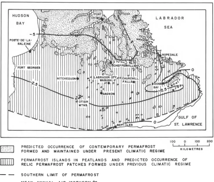
L A B R A D O R
100 0 100 200
PREDICTED OCCURRENCE OF CONTEMPORARY PERMAFROST
-
FORMED AND MAINTAINED UNDER PRESENT CLIMATIC REGIME K I L O METRES PERMAFROST ISLANDS IN PEATLANDS AND PREDICTED OCCURRENCE OF
RELIC PERMAFROST PATCHES FORMED UNDER PREVIOUS CLIMATIC REGIME
-
-
SOUTHERN LIMIT OF PERMAFROST-
MEAN ANNUAL AIR ISOTHERM,OCFIGURE 1. Permafrost distribution in Nouveau-Quebec and La rbpartition du perg6lisol au Nouveau-QuBbec et au La- Labrador (after BROWN, 1967, 1978; IVES, 1962). brador (d'apres BROWN, 1967, 1978; IVES, 1962).
PERMAFROST DISTRIBUTION
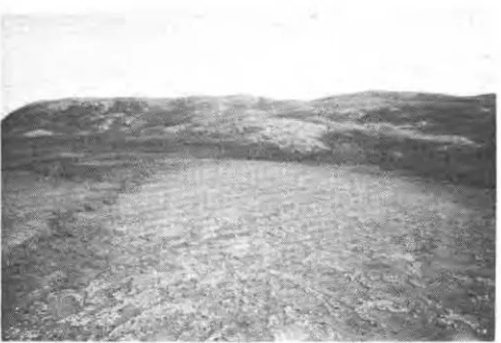
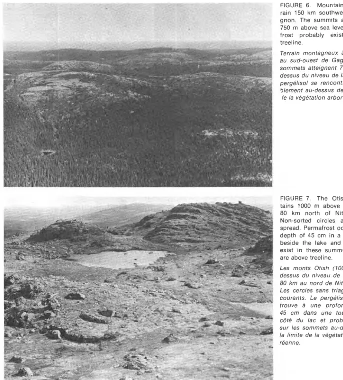
The islands of permafrost vary in extent from less than a few tens of square metres to several hectares. The thickness of these patches varies from a few centi- metres to a metre or so at the southern limit of the discontinuous zone to 100 m or more at the northern limit of the subzone under consideration. At Scheffer- ville, for example, permafrost thickness of 120 m has been observed (Fig. 2) in the iron mining region (NI- CHOLSON, 1978). Many of the permafrost islands occur in peatlands associated with peat plateaux and palsas (Figs. 3, 4, 5). Some are found on valley slopes, usually north facing and in other special terrain situations such as where dense tree growth provides heavy shading or the snow cover is thin. Permafrost is also prevalent at high elevations on and near mountain summits which protrude above treeline (Figs. 6, 7). Even as far south as the Chic-Chocs Mountains in the Gaspe Peninsula, per mafrost occurs on treeless summits (GRAY and BROWN, 1979). It has been encountered at high elevations in the iron mines near Wabush and Labrador City to depths exceeding 60 m.
The depth of the permafrost table in the peatlands averages 50 cm with observed variations from a mini- mum of about 35 cm to a maximum of about 85 cm. The permafrost table usually lies in the peat above the mineral soil, the thickness of the peat layer ranging from about 0.6 to 2.0 m with an average of about 1 to 1.3 m. Peat in excess of 3 m thickness has been observed at some locations.
Very few ground temperature measurements are available for this region. The permafrost islands near the southern limit have temperatures ranging from -0.l0C to only a few tenths of a degree cooler. Northward the ground temperatures decrease steadily to the latitude of Schefferville. At this location they are observed to be as low as -2.8% at the 15 m depth (approximate depth of zero annual amplitude) (NICHOLSON and THOM, 1973).
PALSAS AND OTHER PEATLAND FEATURES
Peat plateaux and palsas occur at numerous sites in Quebec and Labrador within the area under considera- tion although they do not appear to be as numerous as in the Hudson Bay Lowland of northern Ontario and Manitoba (BROWN, 1967, 1973). The greatest concen- trations have been observed in the west, between the marine limit of the Tyrrell Sea and Hudson Bay (DION- NE, 1978) and to a lesser extent in the east near the Atlantic coast (BROWN, 1975).
In the west, DIONNE (1978) has mapped the distribu- tion of palsas from the coast of James Bay eastward for 200 km to the approximate boundary of the Tyrrell Sea deposits lying roughly along longitude 76"W. With- in this broad coastal zone, palsas and peat plateaux are very prevalent. To the east their numbers are greatly
reduced. Particularly heavy concentrations of these features are shown by Dionne in the vicinity of Fort George and in the eastern portion of the Tyrrell Sea region between Eastmain River and the Grande Riviere. Two areas of palsas and peat plateaux occur about 50 km and 150 km south of the permafrost region in Figure 1 : Lac Evans at latitude 51 "N and near Matagami at latitude 50°N respectively (DIONNE, 1978).
Various studies have been carried out on palsas and peat plateaux in northwestern Quebec. HAMELIN and CAILLEUX (1969) described the palsas in the basin of Great Whale River. LAGAREC (1978), LAVERDIERE and GUIMONT (1976), PAYETTE et a/. (1976) and SEGUIN and CREPAULT (1978) made extensive investigations on the evolution of permafrost in palsas and other land- forms from the northern portion of the James Bay region to Poste-de-la-Baleine and further north. South- ward, observations have been reported from the vicinity of Fort George (VINCENT, 1977) and Fort Rupert (DION- NE, 1978). These investigators observed that forested ~ a l s a s occur further south than unforested ~ a l s a s . Manv 8 - - - -
are relic especially in the extreme south.
The paisa shown in Figure 3 is typical of those en- countered in this western region. There are 5 in a group each 15 to 30 m long, about 10 m wide and 2 to 3 m high. They have no trees although many palsas are forested (PAYETTE et a/., 1976). The ground cover con- sists of hummocky Sphagnum and lichen (mainly Clado- nia alpestris) below which is Sphagnum peat about 1 m thick overlying silty fine sand. The permafrost table is 50 to 60 cm below the ground surface and the perma- frost is probably 5 to 10 m thick. Cracks extending to a depth of nearly 1 m are scattered over the surface of the palsas. No permafrost occurs between palsas except for a few scattered patches beneath some lichen patches where the active layer is about 50 cm and the thickness of the permafrost 10 to 50 cm.
East of the Tyrrell Sea region there are relatively few palsas until reaching the longitude of Schefferville (67"W). They occur in the Schefferville area and have been noted at various locations to the south, such as on the summit of Mount Wright (now demolished for mining operations) 750 m above sea level. Closer to ~ e p t - i l e s on the Laurentidian Scarp, there are small areas of palsas on summits about 800 m above sea level. Further east, north of Havre-Saint-Pierre and near Harrington Harbour, scattered areas of palsas occur at similar elevations on the Laurentidian Scarp. There are also palsas at elevations up to about 350 m above sea level around Lake Melville.
In the extreme southeast of the region under con- sideration palsas and peat plateaux exist 8 km north of the Strait of Belle-Isle at an elevation of 120 m above sea level. These features, situated in a shallow rock
FIGURE 2. Terrain at Timmins orebody, lron Ore Company of Canada Limited, 32 km north of S c h e f f e ~ i l l e , and 770 m above sea level. Non-sorted circles cover the ground surface. The depth t o the permafrost table varies from 3 t o 4 m and the permafrost extends to a depth of about 100 m.
Le gisement de Timmins 4 de la lron Ore Company of Canada, B 32 km au nord de Shefferville et B 770 m au-dessus du ni- veau de la mer. Des cercles sans triage couvrent la surface. Le perg6lisol se manifeste 21 partir de 3 ou 4 m de profondeur
et son Bpaisseur atteint 100 m.
FIGURE 4. Palsas and peat plateaux 1.5 m high at Cart- wright, Labrador, with vegetative cover of hummocky Spha- gnum and lichen below which is peat 1.2 m thick overlying sandy soil. The permafrost table is 45 cm below the ground surface and the permafrost extends into the mineral soil. No permafrost occurs in the surrounding low areas.
Palses et plateaux tourbeux de 1,5 m de hauteur a Cartwright, Labrador, dont le couvert v6sBtal est composB de buttes de
FIGURE 3. Typical palsa located 40 km south of Poste-de-la- Baleine. It is 15 m long by 9 m wide and 2,5 m high with vege- tative cover of hummocky Sphagnum and lichen below which is peat 0,9 m thick overlying silty fine sand. The permafrost table is 53 cm below the ground surface and the permafrost is probably about 5 to 10 m thick. Permafrost a few centimetres t o 1 m thick occurs in small hummocky Sphagnum lichen areas (incipient peat plateaux) near the palsa. There is no per- mafrost in the surrounding sedge covered areas.
Palse typique situBe a 40 km au sud de Poste-de-la-Baleine; elle mesure 15 m de longueur, 9 m de largeur et 2,5 m de hau- teur. Son couvert vBgBtal se compose de buttes de sphaigne et de lichen sous lesquelles 0,9 m de tourbe couvre un sable fin silteux. Le pergBliso1 se trouve a une profondeur de 53 cm et son Bpaisseur atteint probablement 5 B 10 m. Autour de la palse, une bande de pergBliso1, Bpaisse de quelques centimh- tres B 1 m, apparait dans les zones composBes de petites but- tes de sphaigne (dBbuts de plateaux tourbeux). I1 n'y a pas de perg6lisol dans les terrains couverts de carex a proximit6.
-
sphaigne et de lichen sous lesquelles Une Bpaisseur de 1,2 m FIGURE 5. Aerial view from altitude of 150 m of palsas and
de tourbe recouvre un sol sablonneux. Le perg6lisol se mani- peat plateaux on Neveisik i n Lake M e l v i l l e . feste B partir de 45 c m de la surface et s'6tend jusqu'au sol
min6ral. I1 n'y a pas de pergBliso1 dans les d6pression.s avoi- Vue abrienne, prise B une altitude de 150 m, des palses et des sinantes. plateaux tourbeux de I'ile Neveisik du lac Melville.
PERMAFROST DISTRIBUTION
FIGURE 6 . Mountainous ter-
rain 150 km southwest of Ga- gnon. The summits are about 750 m above sea level. Perma- frost probably exists above treeline.
Terrain montagneux B 150 km au sud-ouest de Gagnon. Les sommets atteignent 750 m au- dessus du niveau de la mer. Le pergelisol se rencontre proba- blement au-dessus de la limite
le la vegetation arboreenne.
FIGURE 7. The Otish Moun- tains 1000 m above sea level 80 km north of Nitchequon. Non-sorted circles are wide- spread. Permafrost occurs at a depth of 45 cm in a peat bog beside the lake and probably exist in these summits which are above treeline.
Les monts Otish (1000 m au- dessus du niveau de la mer) B 80 km au nord de Nitchequon. Les cercles sans triage y sont courants. Le pergelisol se re- trouve B une profondeur de
45 cm dans une tourbiere B c8t6 du lac et probablement sur les sommets au-dessus de la limite de la vegetation arbo- rbenne.
basin in hilly terrain, are 1.3 m high, and each several hundreds of square metres in area. There are no trees; the surface vegetation is Sphagnum and lichen on a peat layer 1.8 m thick overlying stony sandy soil. The permafrost table is 50 cm below the ground surface and permafrost extends into the mineral soil.
Concentrations of pa'lsas 2 to 3 m high are found at Cartwright on the Atlantic coast, on Huntingdon Island
a few kilometres offshore, and on Neveisik Island in Lake Melville. There are no trees and the surface vegeta- tion consists of Sphagnum and grey lichen. Scattered cracks extend to a depth of 60 cm. The peat layer is 60 cm to 1.2 m thick overlying silty sandy soil. The per- mafrost table is 60 cm below the ground surface. The palsas were described initially by HUSTICH (1939) and WENNER (1 947).
Palsas and peat plateaux are the most prominent permafrost features but other indications of existing and past occurrences of permafrost are also evident. Many peatlands and peat bogs have peat plateaux but not existing permafrost. Collapse scars and thermokarst lakes are common, also with no permafrost present (CAILLEUX, 1959, 1971 ; LAGAREC, 1973 ; THIBODEAU and CAILLEUX, 1973). String bogs are very common especially on the Laurentidian Plateau in Labrador (ALLINGTON, 1961 ; HAMELIN, 1957, 1958; POTZGER and COURTEMANCHE, 1955; THOM, 1972). They are not necessarily directly related to the presence of per- mafrost; conditions in these features are usually too wet for perennially frozen ground to form. They also occur south of the permafrost region (DIONNE, 1968) but attain their best development in periglacial conditions where permafrost exists.
PERMAFROST AT HIGH ELEVATIONS AND OTHER PERMAFROST FEATURES
Outside of the peatlands, permafrost and related features are found in other types of terrain particularly at high elevations above treeline on and near mountain summits. Sorted circles, stone nets, and polygonal cracks have been observed on the Mealy Mountains 1080 m above sea level near the Labrador coast, on the Otish Mountains 1000 m above sea level 120 km south of Nitchequon and on summits 540 m and 700 m above sea level north of this location. These features are also present on summits reaching 900 m above sea level on the Laurentidian Scarp north of Sept-iles. In the north-
ern reaches of the area under consideration these sur- face features are more prevalent. Sorted circles and stone nets are widespread in the Schefferville area where permafrost is widespread and more than 100 m thick. They exist south of Schefferville on mountain summits at elevations of 800 m above sea level and near Churchill Falls on summits 650 m above sea level.
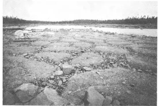
Stone nets 3 to 4 m in diameter also occur in an- other type of location on the Laurentidian Plateau. Near Churchill Falls they were observed on low flat shorelines of the large shallow lakes (Fig. 8). They can also be seen on lake bottoms near the shores in shallow water (DIONNE, 1974). There is a good possibility of perma- frost existing at these sites because the lakes, at least their margins, freeze to the bottom in winter.
Other occurrences of features associated with per- mafrost and periglacial conditions have been observed and reported. On the coast of Labrador north of Rigolet, thaw slumps occur on the south-facing slopes of several river valleys in fine-grained soils (BROWN, 1975). Thaw slumps were encountered on the tree-covered north- facing slope of the Unknown River, a tributary of the Churchill River near Churchill Falls where the existence of permafrost was described by ANDREWS (1961) and CAPLAN (1961). No slumping was observed on the deciduous-covered south-facing slopes. Permafrost was encountered to a depth of 5 m in fill on an island in Lobstick Lake at the hydroelectric construction at Churchill Falls, and at another location, also in till, on an island in Ossokmanuan Lake (Acres Canadian Bechtel Ltd., personal communication).
FIGURE 8. Stone nets about
3 m in diameter at edge of a small shallow lake near Chur- chill Falls. The soil is a mixture of silt, clay and gravel. Perma- frost possibly exists at this site because the lake, although nearby, freezes to the bottom in winter.
Rbseaux polygonaux de pier- res, de 3 m de diametre environ, en bordure d'un petit lac peu profond pres de Churchill Falls. Le sol est composb de silt, d'ar- gile et de gravier. Le pergblisol existe probablement 9 cet en- droit puisque le lac, bien que voisin, gele jusqu'au fond en hiver.
PERMAFROST DISTRIBUTION
The distribution of permafrost in Quebec and Labrador has fluctuated with time in response to changes in climate and terrain conditions. Such ques- tions as: what permafrost is contemporary and what is relic; is the present permafrost in equilibrium with environmental conditions; what was the-distribution of permafrost in the past; and what are the future trends -
all require answers to complete the understanding of permafrost conditions in Quebec and Labrador. The paper in this volume by IVES (1979) presents the most recent information and discussion on these important considerations.
ENVIRONMENTAL FACTORS
Climate is the most important factor influencing the formation and existence of permafrost in the region under consideration. Within this framework the most prominent terrain factors are vegetation, relief, drainage and snow cover.
At the northern boundary of the region under con- sideration, i.e., extending from Poste-de-la-Baleine through Schefferville to Hopedale, permafrost becomes widespread and is found in many types of terrain. West of Hudson Bay the southern limit ,of this widespread subzone of the discontinuous zone generally coincides with a mean annual air temperature of about -3.5% to -4°C. In Northern Quebec and Labrador, however, the same broad relationship does not hold. The mean an- nual air temperature at Poste-de-la-Baleine (55"N lati- tude) is -4.1°C but the -4°C mean annual air isotherm veers southeastward almost to Nitchequon (53"N lati- tude), then northeastward between Churchill Falls (54"N latitude) and Schefferville (55"N latitude), those two sta- tions having mean annual air temperatures of -3.2% and -4.6"C respectively. From here it extends almost due north about 250 km inland from Hopedale, which has a mean annual air temperature of only - 1.7% but
permafrost conditions similar to those at Poste-de-la- Baleine.
CLIMATIC INFLUENCES ON PERMAFROST
Air temperature is the only climatic parameter for which sufficient data are available to permit com- parisons with the distribution of permafrost. In Canada, west of Hudson Bay, the southern limit of permafrost coincides roughly with a mean annual air temperature of - 1°C (BROWN, 1978). This relationship also appears
to hold generally in Quebec from James Bay eastward toward the Strait of Belle-Isle (Fig. 1). In southeastern Labrador, however, the 0°C mean annual air isotherm curves northward placing the Atlantic Coast, between the Strait of Belle-Isle and Cartwright, and the Lake Melville region in an area with higher air temperatures. Palsas exist at Cartwright, where the mean annual air temperature is 0.2%. They may have formed under cooler conditions of an earlier period. Low solar radia- tion values during the summer in this maritime climatic region may also be a factor.
In the southern fringe of the permafrost region, permafrost exists only in certain types of terrain men- tioned at the beginning of this paper, provided the climate is sufficiently cool, i.e., the mean annual air temperature is -1°C or less. Southward, permafrost oc- currences are rare and generally are not found in the same types of terrain because the climate is too warm. A few palsas were noted by DIONNE (1978) near Ma- tagami where the mean annual air temperature is about 0°C. These palsas, which are forested, are disintegrating today. A few widely scattered patches of permafrost, probably relic, and polygonal cracks have been reported in the peat-covered coastal plain along the Gulf of St. Lawrence such as at Mingan Island, 35 km west of Havre-Saint-Pierre (LANDRY and DUBOIS, 1977).
TERRAIN FACTORS
Vegetation is one of the most important components of the terrain, mainly in the role which peat plays in the distribution of permafrost. Most of the occurrences of permafrost in the region under consideration are in peatlands and peat bogs.
The mechanism of permafrost formation in peat ter- rain is known to be related to changes in the thermal properties of the peat through the year. During the summer the surface layers of peat become dry through evaporation. The thermal conductivity of the peat is low and warming of the underlying soil is impeded. The lower peat layers gradually thaw downward and become wet as the ice layers in the seasonally frozen layer melt. In the autumn there tends to be more moisture in the surface layers of the peat because of a decreased evaporation rate. When it freezes the thermal conduc- tivity of the peat is increased considerably. Thus the peat offers less resistance to the cooling of the under- lying soil in winter than to the warming of it in sum- mer. The mean ground temperature under peat will therefore be lower than under adjacent areas without peat. When conditions under the peat are such that the ground temperature remains below 0°C throughout the year, permafrost results and is maintained as long as the thermal conditions leading to this lower temperature persist.
There is a somewhat puzzling aspect of the above- mentioned role of peat in the formation and existence of permafrost. In the region under consideration per- mafrost is absent in the peat at many locations although this peat is sufficiently thick and dry. This type of terrain condition west of Hudson Bay north of the -1°C mean
annual air isotherm usually indicates the presence of permafrost but none occurs at many such sites east of James Bay and Hudson Bay, and eastward into La- brador. At numerous locations where dry peat 1 m and more in thickness is encountered in peat bogs, no per- mafrost exists. The peat is cold to the touch, but not frozen even where the mean annual air temperature is several degrees below 0°C.
The variable relief and existence of high elevations throughout the sutdy area have a significant effect on the distribution of permafrost. It is suggested that per- mafrost exists at all locations above treeline in the dis- continuous zone of Quebec and Labrador (IVES, 1962, 1974). The Mealy Mountains in eastern Labrador and the Otish Mountains (Fig. 7) in Quebec have permafrost on their summits which are above treeline (BROWN, 1975). Other areas with summits above treeline are shown as dark islands on the map of permafrost dis- tribution (Fig. 1) and are typified by the photograph of typical mountainous terrain in Figure 6. Mountain sum- mits near Nitchequon are also above treeline and have permafrost. Palsas can be seen in many peat bogs on mountain summits above treeline, confirming the p r e sence of permafrost. No permafrost was encountered in the townsites of Wabush and Labrador City 540 m above sea level. As mentioned previously, permafrost occurs above 750 m in the nearby iron mines and has been found to depths exceeding 60 m. At Schefferville scat- tered permafrost islands exist in peat bogs near the town at an elevation of about 500 m above sea level. Thick, widespread permafrost exists above treeline at about 700 m elevation where mining operations are un- derway.
Drainage appears to be an important factor related to the occurrence of permafrost in the discontinuous zone. The importance of water conditions is shown by the absence of permafrost in areas where the water table is at the ground surface, even if the ground cover consists of Sphagnum. The extensive string bogs on the Laurentidian Plateau in Labrador are too wet for per- mafrost even in the Sphagnum-covered ridges. In some of these areas, the surface peat layer is thin, only 30 to 50 cm, and mineral soil and boulders are visible in the bottoms of the shallow pools. At many locations in the study area, open wet treeless bogs with no permafrost are bordered or surrounded by slightly higher and drier peatland with scattered tree growth. Scattered per- mafrost islands can be found in only some of these areas so this terrain situation does not guarantee the existence of permafrost.
Regional snowfall conditions appear to be a major factor contributing to the general scarcity of permafrost in the peatlands of Quebec and Labrador located in the southern fringe of the discontinuous zone. The
mean annual snowfall east of Hudson Bay and James Bay ranges from about 200 to 250 cm at the west in- creasing eastward to nearly 500 cm in Labrador (Table I). In contrast to this, the mean annual snowfall west of Hudson Bay varies from a maximum of 200 cm in the Hudson Bay Lowland to lower amounts in central Manitoba. Furthermore, Table I indicates that snowfall is much greater in the fall months, October to De- cember inclusive, east of Hudson Bay than to the west during the onset of freezing air temperatures. The snow cover on the ground during the fall, and over the entire winter, is also about 50 per cent greater east of Hudson Bay. Freezing ground temperatures and the formation of permafrost are therefore considerably inhibited in con- trast to the southern fringe of the discontinuous zone west of Hudson Bay.
The importance of the snow cover has also been demonstrated by investigations at Schefferville. Here it was found that snow is the most important factor con- trolling permafrost distribution and that there is a linear relationship between ground temperatures and snow depth. Permafrost exists generally where the snow cover is less than about 70 cm. Permafrost occurs in ridges where snow cover in thin but not in valley bot- toms where the snow is deep (NICHOLSON and GRANBERG, 1973; NICHOLSON and THOM, 1973).
AIRPHOTO PATTERNS
Aerial photographs reveal a variety of patterns throughout the region under consideration because of the variations in relief, vegetation, soils and drainage. The areas most probably containing permafrost, i.e., the peatlands, can be delineated on the air photos; field investigations to verify its existence or absence can be concentrated in these locations. Within this broad framework, however, the recognition of such permafrost features as peat plateaux and palsas is hindered some- what by their small size on the available photographs. Some peat plateaux do not contain permafrost, which is a complicating feature. North-facing slopes are also potential permafrost areas as are treeless mountain summits. Surface features associated with permafrost include nonsorted circles and stripes, and polygons, all of which are identifiable on aerial photographs. North- ward where permafrost becomes widespread, such as in the vicinity of Schefferville, the identification of perma- frost is complicated by its existence in various types of terrain without associated surface features.
The area shown in Figure 9 was selected from east- ern Labrador to illustrate some patterns, including per- mafrost features. The area with the permafrost features comprises virtually the entire extent except for the rock outcrops on the left side. The most predominant pattern
consists of a network of closely spaced black flecks i n a medium t o light grey mesh-like matrix. The light grey hummocks are palsas and peat plateaux and the black flecks are small ponds.
CONCLUSION
Climate is the most important factor influencing the formation and continued existence of permafrost. This is b o r n e o u t by the location of the mean annual air isotherms relative t o the distribution of permafrost, and indicates the existence of a broad relationship. Per- mafrost is generally n o t f o u n d south of the -1°C iso- therm except i n southeastern Labrador under unusual local conditions. Between the -1°C and -4°C iso- therms, permafrost is patchy and restricted t o certain types of terrain, mainly peatlands. Permafrost is wide- spread n o r t h of the -4°C isotherm.
Permafrost i s m u c h less c o m m o n i n peatlands i n the region under consideration than i n similar terrain condi- tions west of Hudson Bay. The greater snowfall east of Hudson Bay appears t o be the predominant factor causing this situation. Even i n the peat terrain, perma- frost does n o t exist where water lies at o r near t h e g r o u n d surface. I t is restricted mainly t o the positive microrelief peat features
-
peat plateaux and palsas. Drainage is therefore an important terrain factor in- fluencing the existence of permafrost. The excessive wetness of vast peatland areas may b e d u e i n part t o t h e heavy winter snowfall combined w i t h relatively l o w sum- mer evaporation. The role of vegetation i n the distribu- t i o n of permafrost i n peatlands is complex. The tree growth, predominantly spruce with some tamarack, is n o t by itself an indicator of permafrost occurrence be- cause these trees also g r o w o n sites where permafrost is absent. The Sphagnum and lichen cannot b e used as indicators of the existence of permafrost.The distribution of permafrost i n Quebec and La- brador is complicated by relief and elevation. Its exist- ence is m o r e extensive than merely occurring i n peat- lands and i t is f o u n d o n mountain summits and h i g h elevations above treeline where mean annual air tem- peratures are several degrees lower than shown o n the permafrost map (Fig. 1).
REFERENCES
ALLINGTON, K. R. (1961): The bogs of central Labrador- Ungava; an examination of their physical characteristics, Geogr. Ann., Vol. 43, p. 401-417.
ANDREWS, J.T. (1961) : Permafrost in southern Labrador-Unga- va, Dept. of Geography, McGill University, Misc. Paper No. 1, Unpub, mimeo., 5 p.
BROWN, R. J. E. (1967): Permafrost map of Canada, Div. of
Bldg. Res., Nat. Res. Counc. (NRC 9769) and Geol. Surv. Can. (Map l246A)
-
(1973) : Permafrost distribution and relation to environ- mental factors in the Hudson Bay Lowland, Symposium on the Physical Environment of the Hudson Bay Lowland, Univ. of Guelph, p. 35-68.-(1978): Permafrost map of Canada, in Hydrological Atlas of Canada, Dept. of Fisheries and Environment (Map
No. 32).
CAILLEUX, A. (1959): Observations sur quelques lacs ronds nord-americains, Cah. GBogr. QuB., No. 6, p. 139-147. -(1971): Lacs en ourson, cernes et thermokarst, Cah.
GBogr. QuB., No. 34, p. 131-136.
CAPLAN, B. (1961): Beating the permafrost at Twin Falls, Eng. Contract Rec., Vol. 74, No. 11, p. 61-63.
DIONNE, J.-C. (1 978) : Formes et phenomenes periglaciaires en Jamesie, Quebec subarctique, GBogr. phys. Quat., vol. 32, NO. 3 p. 187-247.
GRAY, J. T. and BROWN, R. J. E. (1979): Permafrost pre- sence and distribution in the Chic-Chocs Mountains, Gaspe- sie, Quebec, GBogr. phys. Quat., vol. 33, Nos. 3-4, p. 299- 31 6.
HAMELIN, L.-E. (1957): Les tourbieres reticulees du Quebec- Labrador sub-arctique. Cah. GBogr. QuB., vol. 2, No. 3, p. 87-106.
-
(1958) : Les cours d'eau a berges festonees, Can Geogr., NO. 12, p. 20-24.HAMELIN, L.-E. and CAILLEUX, A. (1969): Les palses dans le bassin de la Grande Riviere de la Baleine, Rev. GBogr. Montr., vol. 23, No. 3, p. 324337.
HUSTICH, 1. (1939): Notes on the coniferous forest and tree limit on the east coast of Newfoundland-Labrador, Acta Geogr. vol. 7, No. 1, p. 5-77.
IVES, J. D. (1962): Iron mining in permafrost, central Labrador- Ungava, Geogr. Bull., No. 17, p. 66-77.
-
(1974): Permafrost, Chapter 4A, p. 159-194, in Arctic and Alpine Environments, J. D. lves and R. G. Barry, ed., London,Methuen, 999 p.
-
(1 979) : A proposed history of permafrost development in Labrador-Ungava, GBogr. phys. Quat., vol. 33, Nos. 3-4, p. 233-244.LAGAREC, D. (1973): Postglacial permafrost features in east- ern Canada, Proc., Second Internat. Conf. Permafrost, North American Contribution, U.S. Nat. Acad. Sc., Washing- ton, p. 126-131.
-
(1978): Caracteristiques de la distribution des palses en Hudsonie (Nouveau-Quebec). Ann. ACFAS, vol. 45, p. 102. LANDRY, B. and DUBOIS, J. M. M. (1977): Un ilot de pergelisoldans le golfe du Saint-Laurent, Ann. ACFAS, vol. 44, p. 94. LAVERDIERE, C. and GUIMONT, P. (1976): Les palses de la
region de Poste-de-la-Baleine, littoral sud-est de la mer d'Hudson, Nouveau-Quebec, Ann. ACFAS, vol. 43, p. 105. NICHOLSON, F. H. (1978): Permafrost distribution and char-
acteristics near Schefferville, Quebec, Proc. 3rd Intern. Conf. Permafrost, vol. 1, p. 428-433.
PERMAFROST DISTRIBUTION
NICHOLSON, F. H. and GRANDBERG, H. B. (1 973) : Permafrost SEGUIN, M. K. and CREPAULT, J. (1978) : Etude physique and snowcover relationships near S c h e f f e ~ i l l e , Proc., d'un champ de palses a Poste-de-la-Baleine, Ann. ACFAS, Second Intern Conf. Permafrost, North American Contribu- Vol. 45. D. 102.
tion, U.S. Nat. Acad. Sc., Washington, p. 151-1 58.
NICHOLSON, F. H. and THOM, B. G. (1973): Studies at the Timmins 4 permafrost experimental site, Proc., Second Internat. Conf. Permafrost, North American Contribution, U.S. Nat. Acad. Sc., Washington, p. 159-166.
PAYETTE, S., SAMSON, H. and LAGAREC, D. (1976): The evolution of permafrost in the taiga and i n the forest- tundra, western Quebec-Labrador Peninsula, Can. Jour. Forest Res., Vol. 6, No. 2, p. 203-220.
POTZGER, J. E. and COURTEMANCHE, A. (1955): Permafrost and some characteristics of bogs and vegetation of north- ern Quebec, Rev. Can. GBogr., Vol. IX, Nos. 2-3, p. 109-114.
.
.
THIBODEAU, E. and CAILLEUX, A. (1973): Zonation en latitude de structures d e thermokarst et d e tourbieres vers 75" ouest, Quebec, Rev. GBogr. Montr., Vol. XXVI, No. 2, p. 117- 138.
THOM, B. G. (1972): The role of spring thaw in string-bog genesis, Arctic, Vol. 25, No. 3, p. 236-239.
VINCENT, J.-S. (1977): Le Quaternaire recent de la region du cours inferieurs d e la Grande Riviere, Quebec, Geol. Surv. Can., ~ t u d e 76-19, 20 p.
WENNER, C. G. (1947): Pollen diagrams from Labrador, Geogr. Ann., Vol. 29, Nos. 3-4, p. 137-373.
priate remittance (a Bank, Express, or Post Office Money Order, or a cheque, made payable to the Receiver General of Canada, credit NRC) to the National Research Council of Canada, Ottawa K I A OR6. Stamps are not acceptable.
A list of all publications of the Division is available and may be obtained from the Publications Section, Division of Building Research, National Research Council of Canada. Ottawa K I A OR6.