91 GÉOLOGIE DE LA FRANCE, N° 1, 2003
Apatite fission-track (AFT) data is a widely used method ideal for monitoring long-term erosion rates and constraining geomorphological models of landscape evolution for different geodynamic settings. This study is concerned with defining the denudation history of part of western Europe, principally hercynian basement rocks distributed around the Paris Basin.
Apatite fission-track thermochronology is widely used by geologists to determine low-temperature thermal histories of upper crustal rocks. Fission tracks are crystal lattice damages produced by the natural fission of 238 Uranium atoms that accumulate in crystals and allow to date rocks. Because fission-tracks are reset at elevated temperatures, measured ages rarely record discrete events such as a rock formation age. Instead most ages relate to a cooling history primarily in response to erosion, although reheating can also occur with sedimentation or tectonic thrusting. For common apatite compositions (Ca5(PO4)3(F,Cl,OH), fission-tracks are stable at temperatures below ~ 50°C, semistable between ~50 and 110 ± 10°C and completely reset above 110°C (for durations of heating lasting between 106 –108 years). By determining an AFT age and measuring the lengths of individual tracks it is possible to reconstruct a sample cooling history through these temperatures. The results when combined with heat flow and rock conductivity data (geothermal gradient) can be used to reconstruct a sample passage through the uppermost (2-5 km) of the Earth’s crust. This information has been extensively used in tectonics -studying orogenic belt and rift zone margin evolution - in geomorphology - measuring long-term denudation rates - in sedimentology, defining timing and volume of sediment supply and thermal history of sedimentary basins (review in Gallagher et al., 1998).
The Paris Basin which covers today an area of ~240,000 km2 is an intracratonic sedimentary basin that experienced
continuous subsidence and sedimentation (up to 3 km thick in the centre) from the Permian until the end Cretaceous (Fig. 1). Sedimentation began by the deposition of Permian conglomeratic sediments in small endoreic basins followed by sands, dolomites and evaporites in the Triassic; marine shales and carbonates in the Jurassic, sands in the Early Cretaceous followed by Chalk in the Upper Cretaceous and thin continental sandstones, clays and few carbonates in the Tertiary (Mégnien et coll., 1980; Guillocheau et al., 2000). The present-day exposure of the Paris Basin shows a concentric distribution of sediments with stratigraphic age decreasing from the borders (Palaeozoic massifs such as Ardenne, Vosges, Morvan, Massif Central and Massif Armoricain) towards the basin centre. Two main phases of deformation have been recognised in the basin. The first, in the Lower Cretaceous, is linked to the opening of the North Atlantic and Bay of Biscay, and the second event, at the end of the Cretaceous/Early Tertiary, is associated with collision between Africa and Europe and formation of the Alps (Wyns et al., this volume).
Extensive diagenetic studies of the Paris Basin have shown that basin sediments previously experienced higher temperatures than at present (Guilhaumou, 1993; Spötl et al., 1993; Demars & Pagel, 1994; Clauer et al., 1995). These high temperatures have been mainly explained by an Upper Cretaceous Chalk cover that has since been eroded (Demars and Pagel, 1994). The original extent of this cover and its thickness are unknown. There is also some evidence that circulating fluids caused widespread cementation in the Triassic and Jurassic sediments causing a significant reduction in their porosity. The driving mechanism for fluid flow has been postulated as topographically driven, at the basin margins. This hypothesis can be tested by reconstructing the uplift history of basement rocks from around the basin margin.
Apatite fission-track thermochronology
in western Europe:
search for weathered/eroded cover rocks
on the Hercynian basement (method,
results, limitations and perspectives)
Jocelyn BARBARAND
(1)Géologie de la France, 2003, n° 1, 91-93, 1 fig.
Key words: Fission tracks, Apatite, Thermal history, Mesozoic, Cenozoic, Denudation, Uplift, Basement, Paris Basin, Morvan, Vosges.
APATITE FISSION-TRACK THERMOCHRONOLOGY IN WESTERN EUROPE
GÉOLOGIE DE LA FRANCE, N° 1, 2003 92
Apatite Fission-Track data from Paris Basin sediments (Geotrack, unpublished report; Pagel et al., 1992) are consistent with several hundreds of metres of erosion but timing is poorly resolved as the samples were collected from hydrocarbon wells at depths where present-day temperatures are high (> 60°C). Clearly, more data is required to better understand the evolution of this basin and its margins. The purpose of this study is to constrain the Mesozoic to Cenozoic thermal history of the Hercynian basement around the Paris basin and address two specific questions:
1) What was the original thickness of sediments in the basin?
2) What is the timing of episodes of basin inversion and associated erosion?
Data acquired in collaboration with Andy Carter (University and Birkbeck College, London) on the Morvan and the Vosges massifs will be presented.
The Morvan massif represents the south-eastern border of the Paris Basin. It has a horst structure delimited by two major faults. Samples were collected from across this basement covering the maximum elevation difference and including Triassic sandstones at the basement-basin interface. AFT ages range between 96±11 and 220±22 Ma
with most of the ages around 200 Ma. AFT mean track lengths are between 10.84±0.41 and 11.93±0.17 µm. The AFT ages and length distributions indicate the samples have resided at moderately low temperatures (< 90°C) for most of their Meso-Cenozoic history, and cooled.
Thermal history modeling for most of the samples shows a period of cooling throughout the Permian-Triassic, a period of low temperature (< 60°C) residence during the Jurassic and a stage of higher temperature around 80-90°C during the Upper Cretaceous/Lower Tertiary. There are three possible explanations for elevated temperatures during the Upper Cretaceous/Lower Tertiary : 1) increase in the paleogeothermal gradient, 2) circulation of hot fluids, and 3) sedimentary burial followed by erosion. This last hypothesis is considered the most likely and using constraints on the thickness of Cretaceous and Tertiary deposits in the Paris Basin (Guillocheau et al., 2000), the results of this study would suggest that up to 1000 m of Upper Cretaceous Chalk once covered the Morvan Hercynian basement. This chalk cover has since been removed by Tertiary erosion.
There is some circumstantial evidence to support deposition of Chalk. Clay-with-flints has been recognised for a long time on the eastern side of the Morvan massif (Arcelin, 1876) and on a larger scale disseminated on the
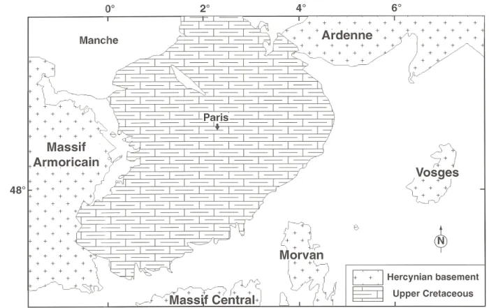
Fig. 1.- Present-day distribution of Upper Cretaceous deposits in the Paris Basin (simplified from the geological map of France at 1:1 000 000). Tertiary formations have not been drawn for clarity.
APATITE FISSION-TRACK THERMOCHRONOLOGY IN WESTERN EUROPE
93 GÉOLOGIE DE LA FRANCE, N° 1, 2003
Morvan surface (Rat, 1968). In collaboration with Florence Quesnel (BRGM), we have investigated the geometry of the weathering profiles and paleosurfaces of the Morvan and its borders. Most of the surface of the massif is covered by small pieces of flints with different colours unsuitable for dating. In well-exposed sections through the Clay-with-flints, we have sampled flints from different horizons to study their micropaleontology (in collaboration with Chantal Bourdillon, ERADATA). Isopach maps of the post-Cenomanian Chalk show the thickness of Chalk is variable across the Paris Basin (Guillocheau et al., 2000). Current thicknesses of remaining Chalk increase from the Northwest to the Southeast ranging from 300 to 700 metres thick. This suggests a greater level of subsidence toward the Southeast which is consistent with a significant chalk cover over the Morvan basement. Maastrichtian Chalk residues are only preserved in the West (Quesnel et al., 1996) and the East (Blanc and Guillevin, 1974) of the basin. Some Maastrichtian deposits are also known in the Cotentin (Normandy), very close to the Massif Armoricain basement and on the Ardenne where they are transgressive on the underlying terrains (Bless et al., 1991). Our flint sampling and their biostratigraphic analyses may help determine if Senonian - Coniacian to Maastrichtian - Chalk once existed over the Morvan.
Samples for AFT thermochronology have been also recovered on the eastern side of the Paris Basin. 31 Hercynian basement rocks and Triassic sandstones have been sampled from Luxeuil-les-Bains (France) to Bitburg (Germany). AFT ages are ranging from 43±6 to 200±14 Ma and FT lengths between 12.00±0.20 to 13.67±0.14 µm. These data clearly indicate that the thermal history of the Vosges area is different from the Morvan massif. AFT data from this area show a clear increase in age from South to North, less clearly from East to West. Rifting of the Rhine graben is the dominant regional event, which explains the bulk of this data. Nevertheless the data do provide some constraints on the possible extent of Cretaceous sedimentation. Preliminary thermal modelling suggests that Cretaceous Chalk deposits were shallow if they did ever exist on the eastern side of the Paris Basin and that inversion and erosion started much earlier than on the Morvan massif.
These data suggest that the Paris Basin was much wider during Upper Cretaceous with the presence of a kilometre thick Chalk layer in the Northeast of the Massif Central. Hercynian basements which form today the borders of the basin have experienced two main stages of uplift : Lower Cretaceous and Upper Cretaceous / Lower Tertiary.
References
Arcelin A. (1876) - Sur l’argile à silex de la côte chalonnaise. Bull. Soc. géol. Fr., IV, 673-675.
Blanc P.-L., Guillevin Y. (1974) - Nouvel indice de Maastrichtien dans l’Est du bassin de Paris. C.R. Acad. Sci., Fr., 273 (D), 465-467.
Bless M.J.M., Demoulin A., Felder P.J., Jagt J.W.M., Reynders J.P.H. (1991) - The Hautes Fagnes area (NE Belgium) as a monadnock during the late Cretaceous. Ann. Soc. géol. Belg., 113, 2, 75-101.
Clauer N., O’Neil J.R., Furlan S. (1995) - Clay minerals as records of temperature conditions and duration of thermal anomalies in the Paris Basin, France.
Clay Miner. GB, 30, 1-13.
Demars C., Pagel M. (1994) - Paléotempératures et paléosalinités dans les grès du Keuper du bassin de Paris : inclusions fluides dans les minéraux authigènes.
C.R. Acad. Sci., Fr., 319 (II), 427-434.
Gallagher K., Brown R., Johnson C. (1998) - Fission track analysis and its applications to geological problems. Ann. Rev. Earth and Planetary Sci., 26, 519-572.
Marshallsea S.J., O’Sullivan P., Brown R.W. (1990) - Apatite fission track analysis of fifteen samples from four wells, Paris Basin. Rapport pour Total, n° 233. Guilhaumou (1993) - Paleotemperatures inferred from fluid inclusions in diagenetic cements : implications for the thermal history of the Paris Basin. Europ.
J. Miner., 5, 1217-1226.
Guillocheau F., Robin C., Allemand P., Bourquin S., Brault N., Dromart G., Friedenberg R., Garcia J.-P., Gaulier J.-M., Gaumet F., Grosdoy B., Hanot F., Le Strat P., Mettraux M., Nalpas T., Prijac C., Rigollet C., Serrano O., Grandjean G. (2000) - Meso-Cenozoic geodynamic evolution of the Paris Basin: 3D stratigraphic constraints. Geodinamica Acta, 13, 189-246.
Mégnien C. (Ed.) (1980) - Synthèse géologique du bassin de Paris, tome 1 : stratigraphie et paléogéographie. Mém. Bur. Rech. géol. minières, Fr., 101, 466 p. Pagel M., Costa S., Galibert F., Lancelot J., Maluski H., Meyer A., Turpin L. (1992) - Géochronologie Sm-Nd, U-Pb, 40Ar-39Ar, K-Ar, Rb-Sr et
chronothermométrie par traces de fission sur le socle. Géologie de la France, 3-4, 129-134.
Quesnel F., Bourdillon C., Laignel B. (1996) - Maastrichtien supérieur au Nord-Ouest du bassin de Paris (France) : témoins résiduels en Seine-Maritime. C.R.
Acad. Sci., Fr., 322 (IIa), 1071-1077.
Rat P. (1968) - Sur le comportement du futur seuil de Bourgogne au Crétacé. Bull. Soc. géol. Fr., 7, X, 393-402.
Spötl C., Matter A., Brévart O. (1993) - Diagenesis and pore water evolution in the Keuper reservoir, Paris Basin (France). J. sediment. Petrol., 63, 909-928. Wyns R. et al. (2003) - Major weathering in France related to lithospheric deformation, this volume.