Abstract
The metallogeny of the Guiana Shield reflects the principal stages of its geotectonic evolution and also the main peculiarities of its geology, the first of which is the presence of large iron-ore deposits, referred as Algoma-type, related to the old Archean Imataca Complex in Venezuela. The second peculiarity is the absence of Middle and Upper Archean units equivalent to the Rio Maria and Carajás provinces of the Central Brazil Shield. The main feature of the Guiana Shield metallogeny is the great diversity of mineral deposits, such as manganese, diamond, chromite and especially gold, associated with the Paleoproterozoic volcano-sedimentary belts. These juvenile terranes underwent intense deformation and shearing induced by tectonic convergence between the West Africa and Amazonian cratons. After the Transamazonian Event, around 2.0 Ga, the Guiana Shield was stabilized and displayed a cratonic Proterozoic evolution characterized by the occurrence of mineral deposits associated with intracratonic granites (Sn), continental clastic sediments (Di), carbonatitic intrusions (Nb, Th, REE) and kimberlitic pipes (Di). The Phanerozoic mineral deposits are associated with Paleozoic marine sediments of the Amazonas Basin (Fe-ool, K-Na), Cenozoic lateritic weathering (Al, Kaol, Mn, Au) and alluvial placers (Di, Au, Sn).
Résumé
La métallogénie du Bouclier des Guyanes reflète les principaux stades de son évolution géotectonique tout comme les particularités majeures de sa géologie, la première d'entre elles étant la présence de grands gisements de minerai de fer, de type Algoma, en relation avec le complexe archéen d'Imataca au Vénézuela.
La seconde particularité est l'absence d'unités d'âge archéen supérieur, équivalentes à celle des provinces du Rio Maria et de Carajas dans le bouclier central brésilien. Le caractère principal de la métallogénie du Bouclier des Guyanes est la grande diversité des minéralisations, telles celles de manganèse, de diamant, de chromite et spécialement d'or, associées aux ceintures volcano-sédimentaires paléoprotérozoïques. Ces formations juvéniles ont subi des déformations et des cisaillements intenses lors de la convergence entre les cratons ouest africain et amazonien. Après l'événement transamazonien, autour de 2 Ga, le Bouclier des Guyanes s'est stabilisé et a connu, au Protérozoïque, une évolution cratonique caractérisée par l'existence de minéralisations associées à des granites intracratoniques (Sn), des sédiments clastiques continentaux (Di), des intrusions carbonatitiques (Nb, Th, REE) et des pipes kimberlitiques (Di). Les minéralisations phanérozoïques sont associées à des sédiments marins paléozoïques du bassin de l'Amazone (Fe-ool, K, Na), une altération latéritique cénozoïque, (Al, Kaol, Mn, Au) et des placers alluviaux (Di, Au, Sn).
Resumo
A metalogenia do Escudo das Guianas reflete as principais etapas de sua evolução geotectônica e os grandes traços de sua geologia. O primeiro estágio se manifesta pela presença de importantes depósitos de ferro, classificados como do tipo Algoma, que são relacionados ao Complexo Arqueano de Imataca na Venezuela. Um segundo traço muito peculiar encontrase na ausência de terrenos correspondentes ao Arqueano Médio e Superior, os quais são predominantes nas províncias de Rio Maria e Carajás no Escudo do Brasil Central. O principal caráter da metalogenia do Escudo das Guianas é refletido pela grande diversidade de depósitos minerais associados aos cinturões
of the Guiana Shield
Métallogénie du Bouclier des Guyanes
Carlos SCHOBBENHAUS
Géologie de la France, 2003, n° 2-3-4, 291-319, 23 fig.
Mots clés : Métallogénie, Guyane française, Guyana, Suriname, Brésil, Vénézuéla, Bouclier guyanais. Key words: Metallogeny, French Guiana, Guyana, Suriname, Brazil, Venezuela, Guyana Shield.
(1) Instituto de Geociências - ICC - Universidade de Brasília, Brasília-DF, CEP:70.910-900. E-mail: dardenne@tba.com.br
vulcano-sedimentares Paleoproterozóicos do tipo Greenstone Belt, como manganês, cromita, diamante e sobretudo ouro. Esses terrenos de natureza juvenil têm sofrido intensa deformação e cisalhamento induzidos pela tectônica convergente entre a África do Oeste e o Craton Amazônico. Os principais depósitos auríferos são relacionados a essas zonas de cisalhamento. Após o Evento Transamazônico, por volta de 2.0 Ga, o Escudo das Guianas estava estabilizado e mostrou durante o Proterozóico uma evolução cratônica caracterizada pela ocorrência de depósitos minerais associados ao magmatismo granítico intracratônico (Sn), aos sedimentos clásticos continentais (Di), às intrusões carbonatíticas (Nb, Th, ETR) e os pipes kimberlíticos (Di). Durante o Fanerozóico, os depósitos minerais são encontrados nos sedimentos marinhos do Paleozóico da Bacia do Amazonas, como o ferro oolítico do Devoniano e os evaporitos (K-Na) no Permo-Carbonífero. No Cenozóico, a intensa alteração laterítica permitiu a formação de importantes depósitos de bauxita, caolim, manganês, ferro e ouro, enquanto diamante, ouro e cassiterita se acumulavam nos placeres aluvionares desenvolvidos ao longo dos rios.
Introduction
The Guiana Shield, located in the northern part of the South American Platform (Fig. 1), constitutes a wide area in which geological knowledge is only at the regional recognition stage. The lack of detailed knowledge is mainly due to the tropical and equatorial climatic conditions favouring the development of a thick weathering lateritic mantle and an outstanding homogeneous tropical forest -global conditions that make traditional geological exploration difficult and restrict access even to the principal rivers.
The region represents a preferential target for the expansion of mineral exploration activities because of the traditional primitive extraction of gold by “garimpeiros” that has been ongoing for several centuries and because of recent discoveries of large gold deposits. In addition, voluminous deposits of iron, manganese, cassiterite and diamonds are known in the region. Collectively, these allow the Guiana Shield to be defined as one of the last extensive areas favourable for large mining discoveries.
The aim of this contribution is to present an up-to-date synthesis of the Guiana Shield metallogenesis through a description of the main characteristics of the known mineral deposits, emphasizing its relationships with the geotectonic evolution of the area.
Geotectonic Setting of the Amazonian
Craton
The consolidation of the South American Platform took place at the end of the Brasiliano Cycle with the
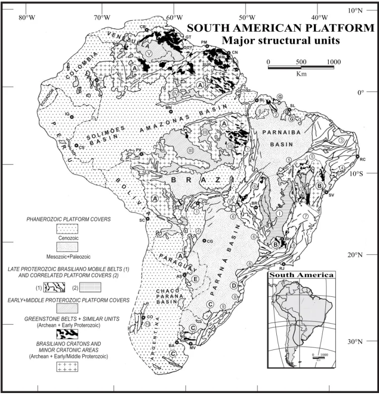
individualization of the Amazonian, São Francisco and Rio de La Plata cratons (Almeida, 1967; Almeida et al., 1976). Geographically, the Amazonian Craton is separated into two blocks by the Amazonas Basin (Fig. 1): the Guiana Shield and the Central Brazil (or Guaporé) Shield.
According to the model proposed by Cordani and Brito Neves (1982), Lima (1984), Teixeira et al. (1989), Tassinari (1996), Tassinari and Macambira (1999), Cordani and Sato (1999), Cordani et al. (2000) and Tassinari et al. (2000), the geotectonic evolution that led to the cratonization of the Amazonian region resulted from a progressive crustal accretion onto an older nucleus that stabilized around 2.5 Ga, at the end of the Archean. In accordance with this concept, the Amazonian craton has been subdivided into six geochronological provinces (Fig. 2): Central Amazônia (>2.3 Ga); Maroni-Itacaiúnas (2.20-1.95 Ga); Venturi-Tapajós (1.95-1.80 Ga); Rio Negro-Juruena (1.80-1.55 Ga); Rondônia-San Ignácio (1.55-1.30 Ga) and Sunsás (1.30-1.00 Ga).
Recently, this model was substantially modified by Santos et al. (2000) who individualize eight Precambrian tectonic provinces (Fig. 3): Carajás and Imataca (3.10-2.53 Ga), juvenile; Transamazonic or Guianas (2.25-2.00 Ga), juvenile; Tapajós-Parima (2.10-1.87 Ga), juvenile; Central Amazon (1.88-1.70 Ga), underplating; Rio Negro (1.86-1.52 Ga), collisional; Rondônia-Juruena (1.76-1.47 Ga), juvenile; K’Mudku (1.10-1.33 Ga), shear belt; and Sunsás (1.33-0.99 Ga), collisional.
Each of these provinces contains specific plutonic, volcanic and sedimentary associations with distinct lithological, geochronological and isotopic features. The progressive stabilization of the Amazonian region occurred during the Proterozoic and terminated at the end of the Mesoproterozoic around 1.0 Ga. At this time, the Amazonian Craton was juxtaposed along its southern and eastern margins with the Paraguai-Araguaia Fold Belt, which closed at the end of the Brasiliano Cycle around 600 Ma. During Phanerozoic times, the main events were related to Paleozoic rifting, which gave rise to the development of the Amazonas Basin and to the Mesozoic opening of the Atlantic Ocean with its incursions into the Amazonian Craton.
Regional Geology of the Guiana Shield
The Guiana Shield (Fig. 4) extends from the Atlantic Ocean margin, in the north and northeast of the South American Platform, to the Amazonas sedimentary basin in the south and to the Andes Belt in the west. It can be divided into: Archean granulitic and gneissic terranes; Paleoproterozoic granite-greenstone belts; Undifferentiated granitic and gneissic terranes; Mesoproterozoic plutonic, volcanic and sedimentary units; Neoproterozoic mafic and
A A B B D E C C C G G A A A V III III I II 1 6 7 8 9 9 10 8 5 5 2 3 4 6 F 1 1 6 III IV V E N E Z U E L A CO LO MB I A P E R U B O L I V I A P A R A G U A Y C H A C O P A R A N A B A S I N AR G E N T IN A P A R N A I B A B A S I N A MA Z O NA S B AS I N S OL I M Õ ES B A S I N P A R A N B A S IN Á B R A Z I L
PHANEROZOIC PLATFORM COVERS
Cenozoic
Mesozoic+Paleozoic
LATE PROTEROZOIC BRASILIANO MOBILE BELTS (1) AND CORRELATED PLATFORM COVERS (2)
EARLY+MIDDLE PROTEROZOIC PLATFORM COVERS GREENSTONE BELTS + SIMILAR UNITS
(Archean + Early Proterozoic)
BRASILIANO CRATONS AND MINOR CRATONIC AREAS
(Archean + Early/Middle Proterozoic) ECUADOR GUY SUR PM GFR CN BL SL BR BH SV RJ MV BA CO AS CU SC CS RC CG CB IQ PV MN MI South America 0 1000 Km
SOUTH AMERICAN PLATFORM
Major structural units
(1) (2) 80°W 70°W 60°W 50°W 40°W 10°N 0° 10°S 20°N 30°N 1000 Km 0 500 GT
Fig. 1.- Major structural units of the South American Platform. Brasiliano cratons and minor cratonic areas: Amazonian (A), São Francisco (B), Rio de La Plata (C), Luís Alves (D), Tibicuary (E), Central Goiás (F), São Luís (G). Selected Proterozoic Platform covers: Bambui (I), Chapada Diamantina (II), Beneficente-Iriri-Teles Pires and others (III), Urupi-Iricoumé (IV), Roraima-Surumu (V). Brasiliano Mobile-Belts: Paraguai-Araguaia (1), Gurupi (2), Borborema Province (3), Sergipe (4), Rio Preto-Riacho do Pontal (5), Brasília (6), Araçuaí (7), Ribeira (8), Dom Feliciano (9), Sierras Pampeanas Orientales (10). Modified after Schobbenhaus and Bellizzia (2000); Schobbenhaus and Campos (1984), Almeida (1978) and others sources referred in text.
AS: Asunción, BA: Buenos Aires, BH: Belo Horizonte, BL: Belém, BR: Brasília, CB: Cuidad Bolivar, CN: Cayenne, CO: Córdoba, CS: Cruzeiro do Sul, CU: Cuiabá, GFR: French Guyana, GUY: Guyana, GT: Georgetown, IQ: Iquitos, MI: Mitu, MN: Manaus, MV: Montevideo, PM: Paramaribo, PV: Porto Velho, RC: Recife, RJ: Rio de Janeiro, SC: Santa Cruz de la Sierra, SL: São Luís, SUR: Suriname, SV: Salvador.
Phanerozoic Covers Volcanics acid-intermediate Covers Basic Volcanism Greenstone belts Granulitic Complex Neoproterozoic Mobile Belts
CentralAmazôniaProvince
> 2.3 Ga Maroni-Itacaiúnas 2.2 Ga - 1.95 Ga Province Rio Negro-Juruena 1.8 Ga - 1.55 Ga Province Ventuari-Tapajós 1.95 Ga - 1.8 Ga Province Rondônia-San Ignácio 1.5 Ga - 1.3 Ga Province Sunsás 1.25 Ga - 1.0 Ga Province Granitoids
Manaus
Atlantic Ocean
AMAZONAS
BASIN
P. Velho
?
1
2
3
4
5
Belém 1 - Iquitos 2 - Purus 3 - Itacoatiara 4 - Monte Alegre 5 - Gurupá Basement Structural HighsFig. 2.- Schematic Map of Amazonian Craton, showing the distribution of geochronological provinces (after Teixeira et al., 1989; Tassinari et al., 1996, 2000). Fig. 2.- Carte schématique du craton amazonien montrant la distribution des provinces géochronologiques.
alkaline intrusions; Phanerozoic sedimentary units; and Cenozoic lateritic and clastic units.
The Archean Imataca Complex, at the extreme north
of the craton in Venezuela, is dominated by migmatite,
granulite, gneiss, amphibolite, quartzite, paragneiss, marble and BIF sequences. It has been metamorphosed to granulite and amphibolite facies and intensively deformed by isoclinal folds and by transcurrent and thrust faults. The east-northeast trend of the Complex cuts the
west-Manaus
Belém
0°00’Georgetown
PERU BRAZILAC
GC
PACIFIC
OCEAN
60°00’WATLANTIC OCEAN
0 500 km Carajás and Imataca Rondônia-JuruenaAraguaia Orogenetic Belt Andes Orogenetic Belt Phanerozoic indiscriminated
K’Mudku Sunsas OTHER UNITS São Francisco Craton
Tapajós-Panma Central Amazon
Transamazonic Rio Negro
COLOMBIA
VENEZUELA
BOLIVIA
Fig. 3.- Major provinces of the Amazon Craton in northern South America. GC=Garzon Complex, Greenvillean. AC=Arequipa Complex, Sunsas-Greenvillian (after Santos et al., 2000).
Fig. 3.- Principales provinces du craton amazonien en Amérique du Sud. GC = Complexe de Garzon, Greenville. AC = Complexe d’Arequipa, Sunsas-Greenville (d’après Santos et al., 2000).
northwest Transamazonian trend along the Guri Fault system. The protolith ages, considered as Early Archean between 3.7 and 3.1 Ga, have been restricted to an interval of 3.2-3.1 Ga in the center and 2.9-2.8 Ga at the borders, revealing two major periods of crust generation (Tassinari et al., 2001). The regional high-grade metamorphism and the migmatite injection (La Ceiba migmatite) have been constrained between 2.78 and 2.67 Ga (Tassinari et al., 2001) and characterize the Aroense Event around 2.8 Ga (Sidder and Mendoza, 1995). To the southwest and southeast, the Imataca Complex is limited by juvenile terranes of the Cuchivero and Pastora Paleoproterozoic
volcano-sedimentary sequences. During the Transamazonian orogeny (2.15-2.00 Ga) the complex was intruded by several granitoid plutons.
According to Tassinari et al. (2001) and Santos et al. (2000), the Imataca Complex is an allochthonous Archean fragment that was incorporated into the Guiana Shield during Late Paleoproterozoic. Other than the Imataca Complex, only a few local occurrences of Archean protoliths have been recognized in the Guiana Shield, such as the exotic terranes at Cupixi (2.9-2.6 Ga) to the northwest of Macapá in Brazil (Lafon et al., 1998).
Marowijne Orapu Bonidoro Southern Paramaka Guri Fault Pastora Botanamo Manaus BRAZIL BRAZIL 0° 4° 8° 70° 66° 62° 58° 54° 50° COLÔMBIA VENEZUELA GUYANA SURINAME FR. GUIANA Takutu F. 0 100 200 300 km Calçoene Macapá Georgetown Paramaribo Cayenne CGSZ 1 Orinoco River 2 3 Cuchivero 24 22 27 Barama Mazurani 5 4 6 28 20 19 29 7 8 9 10 Northern Paramaka 11 12 13 14 15 Vila Nova 16 17 18 31 30 32 26 25 Amazonas Ri v er 21 23 K’muduku
Phanerozoic sediments Middle Proterozoic (Roraima Gr.) Granites (1600 to 1500 Ma) Granites (1800 Ma)
Lower Proterozoic: Felsic Volcanics (Uatumã Gr.) Greenstone Belts Granulites Undifferentiated granites and gnaisses Archean Imataca Complex CGSZ - Central Guiana Shear Zone
Fig. 4.- Schematic geological map of the Guiana Shield showiong the location of the principal mineral deposits (after Dardenne and Schobbenhaus, 2001 [a, b], 2000; Bardoux et al. 1998; Faraco, 1997; Carvalho et al., 1995; Sidder, 1995; Gibbs and Barron, 1993).
1 - San Isidro/Cerro Bolivar (Fe); 2 - El Pao (Fe); 3 - El Callao/Lo Increíble (Au); 4 - Botanamo (Au); 5 - Las Cristinas (Au); 6 - Omai (Au); 7 - Gross Rosebel (Au); 8 - Paul Isnard (Au); 9 - St. Elie (Au); 10 - Camp Caiman (Au); 11 - Yaou (Au); 12 - Dorlin (Au); 13 - Salamangone (Au); 14 - Amapari (Au); 15 - Serra do Navio (Mn); 16 - Ipitinga (Au); 17 - Bacuri (Cr); 18 - Pitinga (Sn); 19 - San Salvador de Paúlo (Di); 20 - Icabarú (Di); 21 - Surucucus (Sn); 22 - Cerro Impacto (Nb, Th and REE); 23 Seis Lagos (Nb, REE); 24 Guaniamo (Di); 25 Jatapu (Fe); 26 Faro (K, Na); 27 Los Pijiguaos (Al); 29 -Moengo/Onverdacht/Paranam (Al); 30 - Almerim/Mazagão (Al); 31 - Jari (Kaolin); 32 - Oriximiná/Porto Trombetas (Al).
Fig. 4.- Carte géologique schématique du Bouclier guyanais montrant la localisation des principaux gîtes minéraux (d’après Dardenne and Schobbenhaus, 2001 [a, b], 2000; Bardoux et al., 1998; Faraco, 1997; Carvalho et al., 1995; Sidder, 1995; Gibbs and Barron, 1993).
The Paleoproterozoic Guiana Province forms two
subparallel granite-greenstone belts that extend 2000 km along the Atlantic Coast of the Guiana Shield, from Venezuela to Brazil, crossing the boundaries of the three Guyanas (Fig. 4). The plutono-volcano-sedimentary sequences have received different regional names: Pastora in Venezuela; Barama and Mazanuri in Guyana; Armina and Rosebel in Suriname; Paramaka and Bonidoro in French Guiana; Serra Lombarda and Vila Nova in Amapá and Pará (Brazil).
The Paleoproterozoic greenstone belts of the Guiana Shield evolved between 2.25 and 2.00 Ga and consist of three main units from base to top: a) mafic and ultramafic metavolcanic rocks with a large predominance of mafic tholeiitic volcanics and rare ultramafic komatiitic volcanics, and in which some mafic-ultramafic complexes are intruded at the base; b) tholeiitic to calc-alkaline metabasalt, meta-andesite, metadacite and metarhyolite; c) metaturbidite sequence of greywacke, volcanoclastic rocks, metapelite and chemical rocks.
The two belts are almost entirely composed of juvenile Paleoproterozoic crust (Milési et al. 1995; Vanderhaege et al., 1998; Norcross et al., 2000). Bardoux et al. (1998) have suggested that the northern megabelt may be older (2.17 Ga) than the southern one (2.10 Ga). A model for the evolution of the Paleoproterozoic granite-greenstone belts of French Guiana (Fig. 5) has been proposed by Vanderhaegue et al. (1998): the initial early volcanism occurred at 2174 ± 7 Ma, and the early calc-alkaline volcanic-plutonic arcs are dated at 2120 ± 2 Ma in Guyana (Norcross et al., 1998), at 2144 ± 6 Ma in northern French Guiana and at 2130 Ma in the volcanic Paramaka Series of French Guiana (Milesi et al. 1995); there are two main calc-alkaline batholitic granite suites, one being related to the first synvolcanic magmatic arc with ages of 2120 to 2160 Ma in French Guiana (Milési et al., 1995) and other related to the final stages of the Transamazonic Event at 2094-2080 Ma in Guyana and French Guiana (Vanderhaegue et al. 1998; Norcross et al., 2000).
Oblique convergence between the West Africa and Amazonian cratons induced collision and crustal thickening accompanied by the development of sinistral strike-slip shear zones.
The Undifferentiated Granite-Gneiss Terranes
occupy the largest area of the Guiana Shield, occurring between the greenstone belts and forming the basement of the volcanic and sedimentary covers of the Uatumã and Roraima groups, respectively. Geological knowledge of these terranes is very poor and isotopic data almost absent. For these reasons, they represent the principal point of discordance concerning the geodynamic reconstitutions proposed by Tassinari et al. (2000) and Santos et al. (2000),
making them the subject of strong speculation and controversial opinions.
Proterozoic Plutonic, Volcanic and Sedimentary Units
Between 2000 and 1950 Ma, Late Paleoproterozoic calc-alkaline continental volcanic rocks of acidic to intermediate composition, locally associated with clastic sediments, were deposited unconformably on the Undifferentiated Granite-Gneiss Terranes. These volcanic rocks, related to the Uatumã Supergroup (Gibbs and Barron, 1983, 1993), are widely distributed throughout the central and western parts of the Guiana Shield. Several regional names have been given applied to the volcanic rocks of the Uatumã Supergroup, such as Surumu and Iricoumé in Brazil, Cuchivero in Venezuela, Burro-Burro and Kuyuwini in Guyana, and Dalbane in Suriname. U/Pb determinations on zircon from rhyolite of the Surumu and Iricoumé formations gave ages of 1969 ± 42 Ma (Schobbenhaus et al. 1994). These volcanics occur at a shallow crustal level and are interpreted as late- or post-collision phases of the Transamazonian Event (Bosma et al. 1983; Reis and Fraga, 1996).
Granitic to granodioritic bodies, dated around 1.85 Ga and locally of subvolcanic nature, were intruded into the volcanic rocks. They host important tin mineralization and their geochemical characteristics are indicative of an anorogenic granitic magmatism.
All these units are overlain discordantly by continental sediments of the Roraima Group (ca. 1.8 Ga), which covers large areas of the central and western part of the Guiana Shield, forming tablelands such as Mount Roraima at the triple frontier between Brazil, Guyana and Venezuela. The Roraima Group consists essentially of conglomerate, arkose, orthoquartzite and smaller amounts of shale and tuff with jasper, deposited in fluvio-deltaic and lacustrine environments. These sediments were intruded by large dykes, mafic sills and small subordinate bodies of continental tholeiitic magma (Avanero Suite) dated at 1789 Ma (Santos et al. 1999, 2000).
The youngest granitic intrusions in the Guiana Shield belong to the Parguaza Suite dated at 1.55 Ga (Santos et al. 1999, 2000). Most of the Parguaza-type granites show rapakivi textures and anorogenic characteristics. Brazil also contains syenite intrusions of alkaline composition, such as Cachorro, Serra do Acari and Mapari, to which the same age (1.5 Ga) has been assigned,. Along the frontier between Brazil and Guyana is the Mutum alkaline intrusion dated at ca. 1.0 Ga. There is evidence of end-Mesoproterozoic faulting, shearing and reworking, related to an important event referred as Orinoquense, K’Mudku, Nickerie or Jari-Falsino and dated around 1.2 Ga in the interior of the Guiana Shield. Most of these faults strike NE-SW and are associated with mylonite and pseudotachylite. Igneous activity during the Neoproterozoic is marked by the intrusion of alkaline
complexes, mafic and felsic volcanic suites and kimberlitic sheets, such as Guaniamo in Venezuela.
The final stabilization of the South American Platform is marked by the closure of the Neoproterozoic Paraguai-Araguaia Belt at around 600 Ma.
Phanerozoic Basins
The Paleozoic evolution of the Guiana Shield is marked in the south by the individualization of the intracratonic Solimões-Amazonas basins with the development of Silurian-Ordovician subsidence along an east-west depression that corresponds probably to the reactivation of
weakness fracture zones (proto-rift) in the basement (Milani and Zalan, 1999).
Rifting and the consequent opening of the North Atlantic Ocean at the end of the Permian and beginning of the Triassic represents the major tectonic event that led to the formation of the sedimentary marginal basins along the oceanic coast and to the reactivation of old fracture zones in the interior of the shield, giving rise to rifting processes and the formation of grabens, such as the Takutu Graben. Extensive mafic and alkaline magmatic activity was associated with the tectonic activity, with diabase sills and dykes, mafic volcanics and alkaline intrusions.
Fig. 5.- Geodynamic evolution of French Guiana during the Paleoproterozoic Transamazonian orogeny (after Vanderhaegue et al., 1998).
Fig. 5.- Evolution géodynamique de la Guyane française pendant l’orogenèse transmazonienne paléoprotérozoïque (d’après Vanderhaegue et al., 1998).
North G uiana T rough South Guiana massif (~2.00Ga) Imataca Orapu basin Ile de Cayenne Complex Central Guiana Complex ? ? ? ? ? ? calc-alkaline plutons: 2115 Ma calc-alkaline plutons: 2144 Ma high-K plutons: 2093 Ma Leucogranites 2080 Ma Man Province Man Province Ile de Cayenne Complex Orapu basin Central Guiana Complex South Guiana massif Successive formation of calc-alkaline magmatic arcs
Oblique convergence: - formation of pull-apart basins - thickening of magmatic arcs
? Man
tholeiitic volcanics: 2174 Ma
Formation of oceanic crust between Archean blocks
During the Cenozoic, lateritic weathering profiles developed over the exposed Guiana Shield from the beginning of the Tertiary until recent times. The final event was the deposition of fluvial continental sediments in the interior of the shield.
Iron Deposits of the Imataca Complex
Among the various lithologies of the Imataca Complex, it is the banded iron formations (BIF) enriched by lateritic weathering that gave rise to the formation of major iron-ore deposits such as Cerro Bolivar, San Isidro and El Pao, with reserves greater than 1855 Mt grading about 63% Fe (Sidder, 1995). The lateritic iron ores are composed predominantly of goethite, limonite, hydrohematite and primary hematite. They are well represented at the tops of hills between 400 and 700 m above the sea level, an elevation that corresponds to the Imataca-Nuria paleosurface developed in the early Tertiary (Sidder, 1995).
The BIF units, underlain by amphibole-pyroxene gneiss, gneiss and amphibolite and associated with metavolcanic and metasedimentary rocks, were formed by chemical precipitation of volcanic exhalative origin. These BIFs essentially contain hematite, magnetite and quartz associated with iron-rich silicate minerals such as greenalite, grunerite and cummingtonite, and other silicate minerals such as sodic amphibole and pyroxene. Their primary thickness varies from a few centimetres to tens of metres and exceptionally to 200 m. The BIFs have been isoclinally folded and occupy the limbs and centers of synclines oriented along the main northeast regional trend of the Imataca Complex.
Secondary manganese-enriched beds are interstratified with migmatic gneiss, amphibolite and granulite. These rocks form part of a sequence consisting of gondite, quartz-biotite schist, amphibole schist and dolomitic marble. The individual manganese beds are generally less than 10 m thick with strike extensions of more than 20 km. Although some authors argue for a Lake Superior Type origin for the BIF, the association of the Imataca Complex BIF with amphibolite and manganese occurrences favours an exhalative volcanic origin and therefore an Algoma Type deposit.
Mineral Deposits of the Paleoproterozoic
Province
Various mineral deposits (gold, manganese, diamond and chromite) are associated with the development of the Paleoproterozoic plutono-volcano-sedimentary sequences.
Gold Deposits of the Granite-Greenstone Belts
The numerous gold deposits associated with the granite-greenstone belts are hosted by metasomatized lava
(Dorlin, Las Cristinas, Lo Increíble, Paul Isnard), BIFs (Ipitinga, Amapari), turbiditic sedimentary sequences (Gross Rosebel, Camp Caiman), calc-alkaline intrusives (Omai, St Elie, Salamangone), and conglomerates (Santa Maria, Tortue, Regina).
Most of these rocks have been affected by ductile-brittle deformation under greenschist-facies conditions accompanied by hydrothermal alteration, and have been exposed to lateritic weathering near the surface.
Volcanic-Hosted Gold Deposits
The best examples of the volcanic-hosted gold deposits are Dorlin in French Guiana and El Callao/Las Cristinas in Venezuela. However numerous gold occurrences are known throughout the Paleoproterozoic Province.
Dorlin Gold Deposit
The Dorlin Gold Deposit (Lerouge et al., 1999) in French Guiana is hosted by intermediate to acidic volcanic rocks (dacite, porphyry lavas, volcanoclastics, pyroclastics and crystal tuff) and several subvolcanic bodies interlayered with some fine-grained sediments and cherts. All these units belong to the Paramaka Group.
It is interpreted as a multistage hydrothermal deposit (Fig. 6) with an early tourmalinite-sulphide-bearing stratabound mineralization (M2) surrounded by a large outer zone of chlorite-sulphide mineralization (M1), affected by the first D1 deformation followed by the formation of a quartz-muscovite stockwork (M3) during a post-D1and pre-D2deformational event.
The M1hydrothermal mineralization, which forms the outer zone, consists essentially of oriented chlorite and disseminated sulphides, quartz and carbonates. The sulphides display low gold grades ranging from 1 to 5 g/t, and are represented by predominant pyrite with common traces of chalcopyrite, arsenopyrite, grey copper and minor proportions of sphalerite, pyrrhotite, digenite, tennantite, covellite and tellurides.
The M2hydrothermal mineralization, which forms the inner zone, consists of abundant tourmaline and quartz with disseminated sulphides and carbonates. The pyrite is predominant, with common traces of chalcopyrite, sphalerite, pyrrhotite, digenite, tennantite, covellite and tellurides. Arsenopyrite is absent in the M2mineralization. The M3hydrothermal mineralization forms a stockwork of quartz-muscovite-sulphide-carbonate-bearing veinlets associated with a local massive quartz-muscovite assemblage. The ore, consisting of predominant pyrite with minor chalcopyrite, galena, pyrrhotite, sphalerite and tellurobismuthinite, does not contain arsenopyrite and
shows a significant increase in the gold grades, which commonly exceed 5 g/t.
The gold is native in all three stages of mineralization and occurs as a) fine primary pure inclusions in pyrite, arsenopyrite and chalcopyrite, b) grains contemporaneous with tellurides and as inclusions in hessite, chalcopyrite
and pyrite, and c) isolated particles or locally included in digenite veinlets cross-cutting the pyrite grains.
Two principal orebodies have been identified: the first is contained in a chlorite-sulphide envelope with reserves of approximately 5 Mt at 2 g/t Au; the second is contained in hydrothermal tourmaline-silica-pyrite alteration with high gold values of 1-5 g/t Au, but has not been delimited.
El Callao District
The El Callao District in Venezuela (Sidder, 1995) is underlain by the Pastora volcano-sedimentary sequence, which consists of tholeiitic mafic volcanics, tholeiitic to calc-alkaline basalt to rhyolite intercalated with turbiditic greywacke, volcanoclastics and chemical sedimentary rocks. The mineralization, hosted in quartz veins from 2 cm to 10 m thick and 250 m in depth, comprises native gold and minor amounts of pyrite, tetrahedrite, chalcopyrite, bornite, scheelite, molybdenite, galena, pyrrhotite and sphalerite. Tourmaline and mariposite (chrome mica) are variably present in the veins. Hydrothermal alteration affected all the rocks, giving rise to carbonatization (ankerite, siderite, calcite), propylitization, sericitization and silicification.
Other known gold districts in Venezuela, such as Las Cristinas (8.6 Mt ore at 0.04 oz/t), Lo Increíble and Km 88, are characterized by the presence of gold-quartz-tourmaline veins with a low sulphide content (pyrite, chalcopyrite, molybdenite) associated with shear zones.
BIF-hosted Gold Deposits
In the Vila Nova Belt, gold mineralization is preferentially hosted by banded iron formations interlayered with schist and some quartzite (Fig. 7), such as in the Serra do Ipitinga District and Amapari Deposit.
Serra do Ipitinga District
The Vila Nova volcano-sedimentary sequence in the Serra do Ipitinga District (Fig. 8), is composed dominantly of mafic metavolcanics at the base, overlain by BIFs and clastic metasediments such as quartzite, schist and metagreywacke. The sequence, dated at 2264 ± 34 Ma by Sm-Nd (Faraco and McReath, 1998), was intruded by leucogranite with probable age around 2080 Ma through analogy with French Guiana (Milési et al., 1995).
Three types of mineralization have been recognized at Serra do Ipitinga (Faraco, 1990, 1997): a) sulphide mineralization of the hydrothermal volcanogenic type (VMS), associated with quartz-chlorite schist in contact with a banded iron formation – it is anterior to the first regional metamorphic event and is composed of pyrrhotite, pyrite, chalcopyrite and sphalerite, that contain gold and silver; b)
Dacitic rocks Volcanoclastic rocks Subvolcanic rocks
Chlorite-sulphide-bearing hydrothermal mineralization Tourmaline-sulphide-bearing hydrothermal mineralization Muscovite-quartz-sulphide veins and stockwork Chert Volcanoclastic rocks Breccias Chert Dacitic rocks M2 M1 M3
Fig. 6.- Schematic reconstitution of the Dorlin gold deposit (after Lerouge et al., 1999).
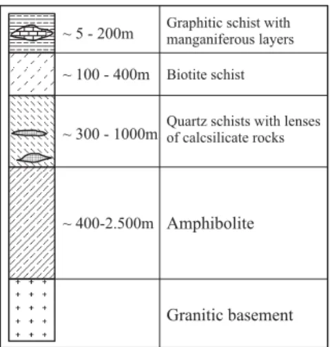
Fig. 6.- Reconstitution schématique du gîte aurifère de Dorlin (d’après Lerouge et al., 1999). ~ 400-2.500m ~ 300 - 1000m ~ 100 - 400m ~ 5 - 200m Granitic basement Amphibolite
Quartz schists with lenses of calcsilicate rocks Biotite schist Graphitic schist with manganiferous layers
Fig. 7.- Lithostratigraphy of the Lower Volcanic Sequence of the Vila Nova Group (after Spier and Ferreira Filho, 1999).
Fig. 7.- Lithostratigraphie de la séquence volcanique inférieure du groupe Vila Nova (d’après Spier et Ferreira Filho, 1999).
hydrothermal mineralization of the lode type, associated with gold-quartz veins containing some chalcopyrite, pyrite and covellite together with epidote and tourmaline; and c) supergene mineralization developed by lateritic weathering with a concentration of gold along the alteration profile.
Amapari Deposit
The Amapari gold deposit, recently discovered by AngloGold (Borges, 1999), is hosted by the Vila Nova volcano-sedimentary sequence, which is intruded by the Amapari leucogranite (Fig. 9). The primary mineralization, which is associated with a sinistral high-angle transcurrent shear zone, extends for 7 km along strike and occurs preferentially in the BIFs and schist affected by intense hydrothermal alteration, mainly silicification, sulphidization and carbonatization, in reactive rocks (Melo et al., 2001), but without large quartz veins. The gold is related to sulphide minerals such as pyrrhotite and pyrite, while chalcopyrite, galena and marcasite occur in small amounts. A Pb-Pb age of 2118 ± 32 Ma has been determined from the sulphides. The
weathering profile reaches depths exceeding 100 m; the reserves of colluvial and oxidized material (Borges, 1999), for a cut-off grade of 2.13 g/t Au, are about 30 t Au. There is still a considerable potential for primary gold mineralization. Fluid-inclusion studies (Melo and Villas, 2001) have shown CO2, H2O-CO2 and H2O fluids with low salinities and homogeneization temperatures between 270-420 °C and 145-230 °C respectively.
Turbidite-hosted Gold Deposits
According to Bardoux et al. (1998) the Armina Formation consists of a thick turbiditic sequence that lies unconformably on the Paramaka and Barama-Mazaruni lavas. Clastic fragments of the Armina sequence are composed of mafic and ultramafic volcanics, BIFs, and granitic rocks, mainly tonalite and granodiorite are referred to the Guyanais and Caraibes suites. This flysch-like sequence, which is also affected by one or two intensive phase of ductile-brittle deformation, occurs in a narrow basin parallel to the volcano-plutonic complexes of the GEOLOGIC MAP F E A B 0 1 2 3 km Rio Ipitinga Ig . E RIO IPITINGAF SCHEMATIC SECTIONS A B
BIF (oxide) clastic metasediments BIF (silicate) clastic metasediments Mafic metavolcanics
Gneiss, migmatite and granitoid Intrusive granite
Outcrop of intrusive granite not differentiated
Contact Fault Foliation
Vertical projection of the conductive body at the surface Conductive body RIO IPITINGA Ig . P u rgat r ói o F . d o s P at o s d os P at o s
Fig. 8.- Schematic geologic map and sections of the Serra do Ipitinga gold deposit (after Faraco, 1997). Fig. 8.- Carte géologique schématique et coupes du gîte aurifère de la Serra do Ipitinga (d’après Faraco, 1997).
northern and southern greenstone belts (Vanderhaegue et al. 1998; Bardoux et al., 1998). The rhythmic alternations of graded greywacke, sandstone and tuff have been deposited from south to north.
Gross Rosebel Deposit
According to Bardoux et al. (1998), the Gross Rosebel gold deposit consists essentially of sulphide-quartz vein
systems that affect the Armina Formation and was formed within three distinct settings (Fig. 10): a) along stratigraphic contacts between volcanics and clastic sediments; b) along plunging fold axes; c) along subvertical shear zones. Reserves at Gross Rosebel have been estimated at around 49 Mt of ore grading 1.6 g/t Au, mostly in soft weathered rocks (60%) and with a large potential laterally and in depth.
Camp Caiman, Regina and Saint Pierre Deposits
The Camp Caiman, Regina and Saint Pierre gold deposits in French Guiana are associated with quartz-tourmaline tension gashes developed perpendicular to the fold axes affecting quartz-pebbly conglomerate. In this context the gold is clearly associated with the quartz veining and with the metasomatic alteration and sulphidization that accompanied the formation of the veins (Bardoux et al., 1998; Manier, 1990).
Plutonic-hosted Gold Deposits
The plutonic-hosted gold deposits in the Paleoproterozoic Province are associated with quartz veins developed in shear zones that affected quartz monzodiorite and granite intrusions, such as described at Omai in Guyana, St. Elie in French Guiana and Salamangone in Brazil.
0 1 2 km 51°59’45” 51°52’05” 0°57’05” 0°49’24” Amapari R iver Serra do Navio B R -2 10 Campo Urucum Campo Taperebá Pedra Branca Granite
Amphibolites;BIF; muscovite quartzite and magnetic itabirite
Gnaiss and tonalite
Garimpos Ore bodies W E 0 20 40 60 80 m Scale 1:1000 200 100 0 -200 -100 Oxide BIF Oxide silicate BIF Granite Garnet-cordierite-tourmaline-quartz schist Colluvium Quartz-biotite schist/Hornblend-biotite-quartz schist Skarnites
Fig. 9a.- Geological map of the Pedra Branca do Amapari region (after Melo and Villas, 2001).
Fig. 9a.- Carte géologique de la région de Pedra Branca do Amapari (d’après Melo et Villas, 2001)
Fig. 9b.- Geological cross section of the Urucum field (after Melo and Villas, 2001).
Fig. 9b.- Coupe géologique du gîte de Urucum (d’après Melo et Villas, 2001).
Omai Deposit
The Omai deposit of Guyana is the most significant gold mineralization known in the Guiana Shield (42 million oz.). It is hosted in mainly subhorizontal and secondarily subvertical quartz veins located in the quartz monzodiorite Omai stock, which has been dated at 2094 ± 1 Ma (Norcross et al., 2000). The stock intrudes the Mazaruni volcano-sedimentary sequence, which was formed in a back-arc/island-arc setting (Lafrance et al., 1999) at 2120 ± 2 Ma (Norcross et al., 2000). The veins are related to brittle fractures, are undeformed and form swarms with a typical stockwork aspect. Pyrite is the most common sulphide in the mineralized quartz veins where it is associated with some galena and Au-Ag-Pb-Bi tellurides. The gangue minerals consist mainly of quartz and ankerite and subordinately of scheelite, albite, calcite, sericite, chlorite, epidote and tourmaline. Native gold occurs as small globular inclusions in pyrite, associated with galena and tellurides and as irregular coarse grains. The Omai deposit was formed at temperatures between 250 and 170 °C in an epizonal environment (Lafrance et al., 1999). The gold was trapped during the shearing deformation around 1995 Ma after the intrusive event.
St. Elie Deposit
The St. Elie deposit in French Guiana is associated with a quartz stockwork located in the Devis granite. The granite
was intruded, at 2140 Ma, in the Paramaka volcano-sedimentary sequence that formed in a volcanic-arc environment (Lafrance et al., 1999). The predominant subvertical NW-SE-striking quartz veins are subparallel to the regional foliation. Subordinate extensional subhorizontal veins are also present and were formed during the same deformation event. Biotite schist bodies surround the boudinaged quartz veins and were probably formed by potassic alteration associated with the mineralizing fluids. Mineralized veins contain pyrrhotite, pyrite, galena, chalcopyrite, native gold and minor molybdenite and Bi-Fe-Ag-Au tellurides. Gangue minerals are quartz, calcite, biotite, chlorite, muscovite and minor scheelite and tourmaline. The St. Elie deposit was formed at temperatures higher than 350 °C in a mesozonal environment (Lafrance et al., 1999).
Salamangone Deposit
The Salamangone deposit in Amapá, Brazil, (Ferran, 1988) is contained in subvertical quartz veins associated with a shear zone within tonalite and granodiorite plutons (Fig. 11) dated at 2155 ± 13 Ma (Nogueira et al., 2000). The plutons intrude the Serra Lombarda volcano-sedimentary sequence, which is related to a magmatic-arc development. Native gold occurs mainly as fine particles (67 to 75 µm) in arsenopyrite and subordinately in association with pyrrhotite, loellingite and chalcopyrite.
Laterite Sandstone
Mineralized Shear Zone Conglomerate
Mineralized Contact Zone Volcanics 400 m g Au/t/metre
GROSS ROSEBEL
4.8/14.0 500 m 400 mN
S
100 m 0.8/2.0 0.8/2.0 4.7/2.0 1.9/6.0 5.1/2.0 2.4/2.0 2.3/4.0 5.3/16.0 4.8/14.0 1.7/8.0 1.0/12.0 1.3/6.0Saprolite
Transition
Bedrock
Fig. 10.- North-south cross-section through of the Gross Rosebel deposit showing the stratigraphic and structural control on the mineralization (after Bardoux et al., 1998).
Fig. 10.- Coupe N-S à travers le gisement de Cross Rosebel montrant le contrôle stratigraphique et structural de la minéralisation (d’après Bardoux et al., 1998).
Conglomerate-hosted Gold Deposits
In French Guiana, the Armina Formation is overlain by clastic sediments of the Upper Sedimentary Unit (Vanderhaegue et al., 1998; Milesi et al., 1995) deposited in pull-apart basins along the outstanding sinistral shear zone that limits the “Sillon Nord Guyanais”. The sequence is dominated by monogenic quartz-rich conglomerate and sandstone. In the Tortue area and the Regina Basin the sedimentary sequence also comprises polygenic conglomerate interpreted as debris-flow products deposited from south to north.
In Amapá (Brazil), the Santa Maria gold deposit (Spier and Ferreira Filho, 1999) is hosted in coarse clastic sediments of the Upper Sediment Unit (Vanderhaegue et al., 1998) that partly overlies the Bacuri mafic-ultramafic Complex and consists mainly of metaconglomerate, conglomeratic quartzite, quartz schist, quartzite, itabirite and metachert (Fig. 12). The gold is concentrated (Fig. 13) in: a) a guide level at the base, constituted by a 5-15
m-thick sequence of foliated microconglomeratic quartzite with millimeter- to centimeter-thick bands of gold-rich tourmalinite associated with quartz veins concordant to the foliation; b) a polymict basal conglomerate, 8-13 m thick over an erosional unconformity, containing 15-60 cm-long clastic pebbles of mica schist, mafic and ultramafic rocks, and quartz in an abundant matrix of quartz, feldspar, sericite and accessory minerals such as tourmaline, fuchsite and chromite —it contains the best concentrations of gold with grades reaching 19 g/t Au; and c) oligomict metaconglomerate interlayered with quartzite —it displays large gold anomalies, suggesting a detrital origin. Reserves were estimated in 1.3 Mt ore grading 0.8 g/t Au. These conglomeratic gold deposits have been correlated with the famous Tarkwa gold mines in Ghana (Milesi et al., 1995).
Serra do Navio Manganese Deposits
The Serra do Navio manganese deposits extend for 10 km along a N30°W strike. They are associated with the
N
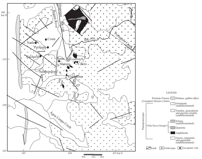
Cibois Lourenço Mutum Salamangone Isaac Yosbidome Costa Cachoeira Nadir Periquito Água Limpa Creek Português Creek Oiapoque BR-156 Regina River BR-156 260 km N 255 250 245 245 430 435 km EDiabase, gabbro dikes Granitoids (undifferentiated) Tonalite, granodiorite and gneissic-tonalite (undifferentiated) Schists (undifferentiated) Quartzite Anphibolite Gneiss, migmatite and granitoids (undifferentiated) Fault Gold mine Au-quartz vein (Vila Nova Group?)
Permian-Triassic (Cassiporé Intrusive Suite)
Paleoproterozpic
LEGEND
0km 1km 2km
Fig. 11.- Geological sketch map of the Lourenço Gold District (after Nogueira et al., 2000).
Vila Nova volcano-sedimentary sequence, which may form a third belt to the south, located at the limit between Amapá and Pará states. This sequence (Fig. 7), dated at 2264 ± 34 Ma by Sm-Nd (Faraco and McReath, 1998), consists of a thick unit of mafic volcanics (Jornal Formation) at the base, overlain by a unit dominated by schist (Serra do Navio Formation), including biotite schist, graphite schist and quartz schist, intercalated with manganiferous layers, BIF and quartzite beds in the upper part (Rodrigues et al., 1986; Scarpelli, 1966). The absence of felsic volcanic rocks is a characteristic of the Vila Nova belt and differentiates it from the Paramaka and Pastora-Barama-Marazuni belts. The basal mafic metavolcanics are sub-alkaline basalt formed in a back-arc basin environment (Faraco, 1997). The sequence has been highly folded, sheared and metamorphosed in the amphibolite facies.
The manganiferous zones (Fig. 14), which constitute the proto-ore of the queluzite-type, are intercalated with graphitic schist and consist dominantly of rhodochrosite (50-90% of the rock). Manganese silicate minerals, such as tefroite, spessartine and rhodonite may predominate to form true gondite in the more impure zones. The Mn-grade of the proto-ore varies between 19% and 36%. Some sulphide minerals, such as pyrrhotite, molybdenite, chalcopyrite and galena, are found in small amounts in the proto-ore. The laterite weathering profile under the equatorial climate may reach a depth of 100 m, altering the carbonate and silicate minerals of the manganese-rich rocks to oxides, such as cryptomelane, pyrolusite and manganite, and giving a rich oxide ore with up to 56% Mn. Open-pit mining began in 1956 in the oxide ore and continued until 1997 with an output of 520,000 tpa, or a total production over the period reaching 50-60 Mt MnO2. During the final years of operation, the carbonate-rich proto-ore was mined at a rate of about 150,000 tpa, equivalent to a total production around 3 Mt of manganese ore with an average grade of 35-38% Mn.
Dachine Diamond Occurrence
A new type of diamond occurrence has been recently described in the Dachine area of French Guiana, where the diamondiferous talc schist is associated with the second calc-alkaline volcanic suite interlayered with immature sediments (Vanderhaegue et al., 1998). The talc-carbonate-albite schist with occasional phlogopite, which includes a few relict high-pressure minerals such as garnet, chromite and diamond, is interpreted by Capdevila et al. (1999) as a metakomatiite based on its high Mg content, trace-element composition and volcanoclastic texture. Bailey et al. (1998) suggest a number of possibilities for the protolith, such as kimberlite, paleoplacer or ultramafic complex. Denny (in Magee Jr. 2001) favours a boninite origin for the host rock. McCandless et al. (1999) suggested that this rock might have been a lamproite, based on diamond resorption.
The diamond population consists mainly of microdiamonds, the largest stone recovered being ca. 4.6 mm in diameter. The morphology of the unbroken diamonds differs from those commonly found in kimberlite (>90% octahedral shape) with only 50% being octahedral, 33% cuboid and 16% tetrahexahedroidal (McCandless et al., 1999). The carbon isotopic signature (Magee Jr., 2001) of most of the Dachine diamonds is different from the signature of diamonds found in kimberlite (heavier than –17‰ PDB) with a concentration around -25‰, similar to organic carbon and to the values found for carbonado. Like carbonado, the individual crystals are small (200 µm), cuboid and old (2.1-2.2 Ga). The N content of the Dachine
Basement/
Mafic-Ultramafic rocks Quartzite with conglomerates
lenses Quartz schist Basal metaconglomerate
Quartzite with metaconglomerate Quartzite Sericite schist BIF Schist > 1,000m > 1,000m ~ 10-200m ~ 8-15m ~ 70-80m ~ 100-300m ~ 5-100m ~ 20-100m Au 10 g/t 9 8 7 6 5 4 3 2 1 0 0 5 10 15 23π 19,2 Microconglomeratic quartzite (guide level) Quartzite Diabase Metaconglomerate
Fig. 12.- Lithostratigraphy of the Upper Detrital Sequence of the Vila Nova Group (after Spier and Ferreira Filho, 1999).
Fig. 12.- Lithostratigraphie de la séquence détritique supérieure du groupe Vila Nova (d’après Spier et Ferreira Filho, 1999).
Fig. 13.- Distribution of gold in the Santa Maria deposit (after Spier and Ferreira Filho, 1999).
Fig. 13.- Distribution de l’or dans le gîte de Santa Maria (d’après Spier et Ferreira Filho, 1999).
diamonds (Magee Jr., 2001) is low, generally less than 30 ppm, showing extremely unaggregated N spectra (type II). Type IaA and IaB diamonds, which dominate the population of most kimberlite, are completely absent in the Dachine diamond population. The low temperature suggested by the low nitrogen aggregation state is consistent with the high proportion of cubic crystals in the Dachine diamond population and consequently the protolith could not be a komatiite according to Magee Jr. (2001), who favours a picritic high-K or shoshonitic arc magma, which is compatible with the tectonic setting.
Bacuri Chromite Deposit
The chromite deposits are associated with the Bacuri mafic-ultramafic Complex (Matos et al., 1992) which, located to the west of Macapá, is intrusive into medium- to high-grade metamorphic granite-gneiss terranes and related to the Vila Nova Group. According to Spier and Ferreira Filho (1999), the Bacuri mafic-ultramafic Complex includes amphibolite, serpentinite, tremolitite and chromitite and was deformed and metamorphosed in the amphibolite facies. These rocks have a differentiated stratiform character defined in function of the magmatic layering of the cumulate and the chemical characteristics of the observed textures. The principal layer of massive chromitite, with an average thickness of 12 m, is situated in
the interface between the mafic and ultramafic rocks. Thinner layers (up to 3 m thick) of massive and disseminated chromite are observed intercalated in the ultramafic rocks (Fig. 15). The chromite crystals are euhedral and of uniform size (average 0.2 mm). The matrix of the massive chromitite consists mainly of metamorphic silicates such as serpentine, chlorite and tremolite.
According to Spier and Ferreira Filho (2001), chromite grains in the massive chromitite have a homogeneous core and an alteration rim that is enriched in Cr and Fe2+ and depleted in Al and Mg. Their chromite composition changes significantly with stratigraphic position. The consistent variation is well indicated by a progressive upward decrease in the Mg/(Mg + Fe2+) ratio as well a progressive upward increase in the Cr/(Cr + Al) ratio, Fe3+/( Fe3+ + Al + Cr) ratio and TiO
2 content. The significant TiO2 and Fe3+ enrichments in the chromite of the uppermost chromitite are typical of stratiform chromite such as in the Bushveld Complex. Olivine shows an equivalent trend of compositional variation characterized by an upward decrease in Fe and Ni. The cryptic variation of chromite and olivine indicates extensive fractionation within the ultramafic zone. Reversals in the Fo content of the olivine and in the Mg/(Mg + Fe2+) ratio and TiO
2 content of the chromite suggest successive replenishments of the magma chamber with more primitive magma during 0 400 800 1200 m 0 400 800 1200 m 0 100 200 300 400 0 100 200 300 400 A C D B Ig. Sentinela T orre Ig. Canção Ig. Antunes Ig. Pedra Preta Rio Amapari Ig. Perdido N30W N55E S30E S55W Ilha T erezinha Rio Rio Igarapé Antunes Schists Gneisses
Amphibolites Manganes queluzite Manganes superficial ore
Massive manganes ore
Fig. 14.- Geological longitudinal and transversal sections of the Serra do Navio manganiferous district (after Rodrigues et al., 1986). Fig. 14.- Coupes géologiques longitudinale et transversale du district manganifère de Serra do Navio (d’après Rodrigues et al., 1986).
Manganese queluzite Manganese superficial ore
the formation of the ultramafic zone. The discovery, within the massive chromitite, of sulphide-bearing intervals (pyrrhotite and pentlandite) as inclusions in the chromite grains and as interstitial masses between the chromite crystals, makes the Bacuri Complex an interesting exploration target for platinum-group-element-enriched horizons (Spier and Ferreira Filho, 2001).
The intense lateritic weathering exceeds depths of 120 m in the topographically elevated localities, allowing a classification of the ore into three categories: lateritic ore, very hard and cemented by iron oxide and hydroxide; friable ore cemented by clay minerals; compact ore cemented by tremolite and chlorite and rarely by orthopyroxene and olivine.
This complex hosts 11 deposits of stratiform chromite with before-mining reserves exceeding 9 Mt of chromitite, of which 2 Mt were mined between 1989 and 1997.
Mineral Deposits of Paleo-Mesoproterozoic
Province
The Paleo-Mesoproterozoic Province is characterized by tin and diamond deposits.
The Pitinga Tin District
The important Pitinga tin district, located 300 km north of Manaus in the southern part of the Guiana Shield, is associated with the Água Boa and Madeira anorogenic granite massifs (Fig. 16) that intruded the consanguineous Iricoumé volcanic rocks at 1.8 Ga (Lenharo, 1998). The Pitinga intrusions are elongate (NE-SW), within-plate, shallow-level, rapakivi granites associated with a deep extensional fracture system. They were formed by magmatic fractionation from distinct sources with two or three stages of crystallization related to processes of decompression during the magma ascension (Lenharo, 1998). Two types of mineralization have been defined in association with the Água Boa and Madeira massifs, respectively.
Água Boa Massif
According to Daoud (1988), Borges et al. (1996), Lenharo (1998), Lenharo et al. (2002), the Água Boa Massif is a polyphase intrusion composed of three distinct facies: rapakivi granite, biotite granite and topaz granite. The mineralization in the Água Boa Massif is associated with hydrothermal processes that formed cassiterite-topaz-mica-quartz greisens hosted in vertical N50°W-striking veins, 1-20 m wide and more than 100 m long. The associated minerals are tourmaline, allanite, opaque minerals, zircon, fluorite, siderite, beryl and sulphide minerals such as sphalerite, pyrite and chalcopyrite. Widespread albitization has been defined as a typical
pre-greisenization process (Borges et al., 1996). The mineralization includes also cassiterite-bearing sodic episyenite (Costi et al., 1996). Greisens and sodic episyenite are spatially associated with K-feldspar-rich zones that occur in all facies of the Massif, but which are predominantly related to the topaz granite and microgranite that have a dyke-like geometry. The greisen mineralization was formed as a consequence of early fluid saturation.
Upper Mafic Zone Lower Mafic Zone Ultramafic Zone > 500 m > 300 m 3- 30 m 30- 120 m Amphibolite Serpentinites with layers chromitite Main chromitite Leuco-amphibolite
Fig. 15.- Stratigraphy of the Bacuri Mafic-Ultramafic Complex (after Spier and Ferreira Filho, 1999, 2001).
Fig. 15.- Stratigraphie du complexe mafique-ultramafique de Bacuri (d’après Spier et Ferreira Filho, 1999, 2001).
0 37’30”O 0 45’O 59 52’30”O 60 00’O 60 07’30”O II II 5 Km I I Albita - granite Topázio - granite Biotite - granite Porphiritic biotite - granite Rapakivi granite Iricoumé volcanics
Madeira Massif Água Boa Massif
Geological contact Fault
Fig. 16.- Geological map of Pitinga Mine (after Lenharo, 1998).
Madeira Massif
According to Daoud (1988) and Lenharo (1998), the Madeira Massif, which is separated from the Água Boa Massif by the Iricoumé volcanics, shows three distinct facies: rapakivi granite, biotite granite and albite granite. The mineralization in the Madeira Massif occurs as disseminated magmatic cryolite, zircon, cassiterite, pyrochlore, columbite-tantalite and xenotime or as massive cryolite in the peralkaline albite granite. Mineralization associated with greisens and other alteration types in the Madeira Massif is minor and located just at the contact of the rapakivi and biotite facies with the border of the albite granite only. The peculiar cryolite bodies may reflect the formation of immiscible fluoride melts during crystallization of the albite granite (Lenharo, 1998; Lenharo et al., 2002). The albite granite can be classified as a mixed NYF-LCT fertile granite, in the sense of Cërny (1991).
The fresh albite granite contains 0.176% Sn, 0.223% Nb2O5, 0.028% Ta2O5, 0.030% U3O8and 0.80% ZrO2. This disseminated mineralization is enriched in the weathered mantle, which is about 30 m thick and depleted with respect to cryolite. Cryolite forms two massive bodies at a depth of about 150 m, at the nucleus of the albite granite. In 1997, the production was ca. 11,693 t Sn from 21,700 t of cassiterite concentrate with 53.88% Sn. The perspectives for the next 15 years are to mine 13 Mtpa of ore corresponding to the equivalent of 13,000 t Sn, in addition to 800 t of columbite concentrate with 35% Nb2O5 and 3.5% TaO2.
Roraima District Diamonds
With the notable exception of the Guaniamo area, most of the known diamond placers in the Guiana Shield are in areas underlain by the Roraima Group or downstream of exposures of this group. There is a pronounced spatial association between the alluvial diamond deposits and the outcrops of the Roraima Group, although no primary diamond occurrence has ever been found within the Roraima Group. These diamond placers form the second group of occurrences of the Shield.
The most important occurrence is San Salvador de Paúl where monthly production is estimated at 2000 carats and total historical production exceeds 2 million carats.. The high percentage of gem-quality diamonds and the absence of other minerals typical of a kimberlitic association suggest a distal source, or more than one sedimentary cycle, or both (Gray and Orris, 1993). Another important locality for diamond placer deposits is Icabarú, which occurs at the southern margin of the Roraima Group near the frontier between Venezuela and Brazil (Brooks et al., 1995). The diamonds in this area are likewise mined from conglomerate derived from the Roraima Group. The main alluvial diamond mining areas occur around or within the
Pakaraima Mountains in Venezuela, Guyana and Brazil. The diamonds are generally regarded as having been derived from Pre-Roraima kimberlite and preserved in the Roraima Group conglomerate. In Venezuela, most of the areas that have been worked are located along the drainage of the Caroni, Paragua and Icabarú in the eastern part of Bolivar State.
Fleischer (1998) suggests an indirect relationship between the intraformational deposition and the subsequent volcanism, with the occurrence of rifting during sedimentation. According to the same author, the diamond production of the Roraima District is related to alluvial gravel. In Brazil, as in Guyana and Venezuela, the source of these alluvial placers is found in conglomerate from the middle of the Roraima sequence and not from the basal conglomerate, which are barren (Fig. 17). Significantly, the great majority of the rivers from the Roraima Mountains are diamond bearing upstream of the basal portion of the sedimentary sequence, as for instance the Suapi and Quinô rivers, which are among the largest producers of the area (Fleischer, 1998).
Surucucus Tin District
The youngest Mesoproterozoic granitic episode in the Guiana Shield corresponds to the intrusion of the Parguaza batholith dated at 1.55 Ga in the extreme part of Bolivar State (Venezuela) and in Amazonas State (Brazil). The Parguaza Granite is massive, unmetamorphosed, coarsely crystalline, porphyritic with a rapakivi texture, and apparently anorogenic in origin (Sidder, 1995). It correlates in age and composition with the Surucucus Granite (Dall’Agnol et al., 1994) in the northernmost Brazil region, which has been dated at 1551 Ma by U-Pb (Santos et al., 1999) and contains extensive cassiterite mineralization with potential reserves of 20,000 t of tin (Schobbenhaus and Campos, 1984).
The Neoproterozoic Alkaline Province
Igneous activity at the end of the Mesoproterozoic and beginning of the Neoproterozoic is reflected by intrusive alkaline complexes in Venezuela and Brazil, by flows of mafic and felsic lavas in Brazil, and by mafic dykes in French Guiana.
Cerro Impacto and Seis Lagos Carbonatites
The Cerro Impacto is a structural feature in Bolivar State (Venezuela) that was first observed on radar images. Preliminary studies showed anomalous values for niobium, thorium, barium and other metals besides REE. Although fresh rock has still not been found, the mineralogy of the products of chemical weathering and leaching suggests that the original composition of the proto-ore was a carbonatite
(gorceixite, goyasite, florencite, bastnaesite, monazite, etc.). The carbonatite is associated with an oval ring structure approximately 10 km in diameter. The weathered mantle, which is at least 200 m thick, does not contain any fragments of the original carbonatite rock. The laterite is enriched in Fe, Mn, Al, Ba, Th, Nb, REE (Ce, La, Nd), Ti, Zn, Pb and other elements.
This body was emplaced near the intersection of large NE-SW and NW-SE fractures that may be related to those into which the Guaniamo Kimberlite was intruded. The age of the carbonatite is not known. However, a Proterozoic age is suggested by a possible relationship with the Guaniamo Kimberlite dated at 710 Ma (Bellizzia et al., 1981; Sidder, 1995; Sidder and Mendoza, 1995; Channer et al., 1998).
The Seis Lagos Carbonatite, located in the headwaters of the Negro River, Brazil, near the frontier with Venezuela, consists of three alkaline-carbonatite stocks mineralized in niobium. Like the Cerro Impacto, the age of this intrusion is not known. The very intense lateritic weathering has resulted in the development of a weathered mantle, more than 200 m thick, in which the pyrochlore was destroyed and the primary niobium minerals have been neomorphosed to rutile and niobiferous brookite. The reserves at Seis Lagos have been estimated at 2898 billion t of ore at 2.81% Nb2O5(Justo and Souza, 1986).
Guaniamo Diamondiferous Kimberlite
Placer diamond deposits in Bolivar State (Venezuela), were discovered in the Guaniamo region in 1968, since when some 20-25 million carats have been recovered, including stones exceeding 40 and 60 carats. In 1982, highly diamondiferous kimberlitic sheets were discovered in the area (Nixon et al., 1992). These intrusive rocks have been dated at 710 Ma (Kaminsky et al., 1998; Channer et al., 1998). According to Channer et al. (2001), at least eight discordant sheets cutting Mesoproterozoic quartz diorite, granodiorite, gabbro and lamprophyre dykes, show individual layers some 8 km long, extending at least 1 km down dip, and with thickness varying from few centimetres to 3.7 m. The sheets strike northwest and with a regional NE dip of 5-20°. Sheet contacts with host rocks are sharp. The kimberlite was forcefully emplaced in fractures opened by magma pressure. Similarities in diamond types and diamond indicator mineral chemistry suggest a common source for all the sheets. The kimberlite has a good preservation of primary igneous (hypabyssal) textures without penetrative deformation. Textures within the sheets show that the kimberlite was emplaced both explosively (xenolith-rich kimberlite) and more quiescently (massive kimberlite). Concentrations of xenoliths or olivine macrocrysts at the base of the sheets show that some
Suapi River (diamondiferous) Quino River (diamondiferous)
N S Rivers without diamonds Serra Araí Conglomerate
(Probable diamond source) Ignimbrite
Dolerite sill Basal polymictic
conglomerate
Aproximately 10 km Surumu volcanics
Fig. 17.- Schematical geologic section of the volcano-sedimentary sequence of the Roraima Group (after Fleischer, 1998). Fig. 17.- Coupe géologique schématique de la séquence volcano-sédimentaire du groupe Roraima (d’après Fleischer, 1998).
gravitational settling occurred. Diamond were found in all the sheets with an average grade of 1.5 cts/t and an average diamond value of US$50-60/ct (Channer et al., 2001). Diamond production from this kimberlite by formal mining methods is expected to be 450,000 carats per year. It should be noted that current production from the entire Guiana Shield is estimated at ca. 250,000 carats per year (L.A. Bizzi, personal communication).
Phanerozoic Ore Deposits
Phanerozoic mineral deposits are associated with Paleozoic marine sediments of the Amazonas Basin and with Cenozoic lateritic weathering and alluvium placers.
Paleozoic Mineral Deposits
Mineral resources of the Paleozoic basins are very limited, being restricted to Devonian oolitic ironstone in the Jatapu region of the Amazonas Basin, and Permo-Carboniferous potassium deposits associated with evaporites in the Amazonas Basin.
Jatapu Oolitic Ironstone
The oolitic ironstone occurrences of the Jatapu River, described by Façanha de Costa (1966) and Hennies (1969), belong to the Devonian Maecuru Group and are associated with quartz sandstone intercalated with micaceous clayey siltite. The oolitic horizon, which can reach 9 m in thickness, displays parallel stratification and abundant cross-bedding. The ironstone is formed by well-sorted spheroidal and ellipsoidal oolites (diameter between 0.10 and 0.20 mm) with quartz nuclei. The mineralogical composition consists mainly of goethite with some hematite and magnetite. The cement between the oolites is goethitic. Lateritic weathering favours supergene enrichment of the iron ore, which can reach 55.5% Fe, 5-10% SiO2, 0.3-1.8% P2O5 and 5.5% Al2O3. The shallow marine sedimentary environment, characterized by high energy and oxidizing conditions, favoured the formation of the goethitic oolites by true accretion.
Faro-Juriti Potassium Deposits
From the Silurian to the end of the Devonian the Amazonas Basin underwent an east to west marine transgression. Following a period of generalized flooding, the basin was tilted slightly to the west, with a concomitant uplift along part of the eastern margin causing an inversion in the direction of the marine incursion, which now became west to east (Fig. 18). The deposition of a transgressive sequence (Monte Alegre and Itaituba formations) was followed by a phase of very restricted circulation resulting in the deposition of the evaporite sequence of the Nova Olinda Formation, with which the potassium deposits are
associated. The Nova Olinda Formation is transitional to the continental sediments of the Indirá Formation (Late Permian). At this time the Amazonas Basin (sensu lato) (including the Solimões Basin) was divided from east to west by the physical barriers of the Iquitos, Purus and Gurupá highs into the Juruá (Upper Amazonas) and Middle Amazonas sub-basins. According to Sad et al. (1982, 1997), the cyclic recurrence of high and low salinity, separated by clastic sedimentation or by less soluble chemical sediments such as limestone and anhydrite, allowed the separation of the evaporitic sequence into 11 cycles. Cycle VII marks the period of greatest restriction of the evaporite basin, with highly saline brines and the deposition of finely crystalline banded halite having a high bromine content (>70 ppm Br), culminating with the precipitation of potassium and magnesium salts in the form of chloride and sulphate. Cycle VII terminated with a fresh-water incursion from continental sources bringing about the development of continental lacustrine conditions.
The potassium-rich zone is divided into three intervals: - A lower interval with milky white, finely laminated sylvinite that grades transitionally to an overlying sequence of finely banded halite beds, implying a primary origin for the chemical precipitation of the sylvinite.
- An intermediate interval, named the sulphate zone, with minerals such as kainite, kieserite, leonite, langbeinite, polyhalite and anhydrite associated with halite and silvinite, implying a marine transgression bringing solutions rich in calcium and sulphate.
- An upper interval consisting of coarse-grained red sylvinite with irregular beds of anhydrite and discontinuous beds of halite. These features, together with the absence of lamination, lead to the interpretation that the original mineral was carnallite that underwent sylvinitization as the result of preferential leaching of magnesium, thus allowing the silvinite to be interpreted as secondary.
Cenozoic Mineral Deposits
The principal mineral deposits during the Cenozoic resulted from the lateritic weathering that developed on the South American Platform from the beginning of the Tertiary, and the accumulation of heavy mineral concentrates as placer deposits in alluvium and paleo-alluvium and in paleo-marine sediments along beaches at the continental margin.
Mineral Deposits of Lateritic Origin
A large part of the South American Platform is situated in the intertropical zone where the predominant conditions favour supergene alteration leading to the development of thick lateritic cover. However, the main phase of


![Fig. 4.- Schematic geological map of the Guiana Shield showiong the location of the principal mineral deposits (after Dardenne and Schobbenhaus, 2001 [a, b], 2000; Bardoux et al](https://thumb-eu.123doks.com/thumbv2/123doknet/15030293.687673/6.892.63.827.103.695/schematic-geological-showiong-location-principal-deposits-dardenne-schobbenhaus.webp)