OATAO is an open access repository that collects the work of Toulouse
researchers and makes it freely available over the web where possible
This is an author’s version published in:
http://oatao.univ-toulouse.fr/19601
Any correspondence concerning this service should be sent
to the repository administrator:
[email protected]
To cite this version:
Carrere, Véronique and Briottet, Xavier and Jacquemoud, Stéphane and Marion,
Rodolphe and Bourguignon, Anne and Chami, Malik and Chanussot, Jocelyn and
Chevrel, Stéphane and Deliot, Philippe and Dumont, Marie and Foucher,
Pierre-Yves and Minghelli-Roman, Audrey and Sheeren, David and Weber, Christiane and
Lefèvre-Fonollosa, Marie-José and Mandea, Mioara The French EO high spatial
resolution hyperspectral dual mission - an update. (2014) In: IEEE International
Geoscience and Remote Sensing Symposium, 13 July 2014 - 18 July 2014
(Québec, Canada). (Unpublished)
THE FRENCH EO HIGH SPATIAL RESOLUTION HYPERSPECTRAL DUAL
MISSION HYPXIM – AN UPDATE
Véronique CARRERE
1*, Xavier BRIOTTET
2, Stéphane JACQUEMOUD
3, Rodolphe MARION
4, Anne
BOURGUIGNON
5, Malik CHAMI
6, Jocelyn CHANUSSOT
7, Stéphane CHEVREL
5, Philippe DELIOT
2,
Marie DUMONT
8, Pierre Yves FOUCHER
2, Audrey MINGHELLI-ROMAN
9, David SHEEREN
10,
Christiane WEBER
11, Marie-José LEFEVRE-FONOLLOSA
12, Mioara MANDEA
131
Laboratoire de Planétologie et Géodynamique de Nantes, UMR CNRS 6112, Faculté des Sciences et
des Techniques, 2 rue de la Houssinière, BP 92208, 44322 Nantes Cedex 03, France
2
ONERA, 2 avenue Edouard Belin, BP 74025, 31055 Toulouse, France
3IPGP, Sorbonne Paris Cité, Université Paris Diderot, UMR CNRS 7154,
35 rue Hélène Brion, 75013 Paris, France
4
CEA, DAM, DIF
F-91297 Arpajon Cedex, France
5BRGM, BP 6009, 45060 Orléans, France
6Observatoire Océanologique de Villefranche (OOV), Laboratoire d'Océanographie de Villefranche
(LOV), Université Pierre et Marie Curie, UMR CNRS 7093, B.P.08,
06238 Villefranche sur Mer, France
7GIPSA-Lab, Département des Images et des Signaux, ENSIEG, BP 46, 38402 Saint Martin d’Hères,
France
8
Météo-France – CNRS, CNRM-GAME UMR3589, Centre d’Etude de la Neige, Grenoble, France
9Université du Sud Toulon Var, LSEET, UMR CNRS 6017, ISITV, Avenue Georges Pompidou, BP 56,
83162 La Valette du Var Cedex, France
10
DYNAFOR, UMR 1201 INRA/ INP-ENSAT / INP-EI Purpan, av. de l’Agrobiopôle, BP 32607,
31326 Castanet-Tolosan, France
11
LIVE UMR 7362, 3 rue de l’Argonne, 67000 Strasbourg, France
12CNES, 18 avenue Edouard Belin, 31401 Toulouse, France
13CNES, 2 place Maurice Quentin, 75039 Paris Cedex 01, France
ABSTRACT
More than 25 years of airborne imaging spectroscopy and spaceborne sensors such as Hyperion [1] or HICO [2] have clearly demonstrated the ability of such a remote sensing technique to produce value added information regarding surface composition and physical properties for a large variety of applications [3]. Scheduled missions such as EnMAP [4], HISUI [5] or PRISMA [6] prove the increased interest of the scientific community for such a type of remote sensing data.
In France, after gathering a group of Science and Defence users of imaging spectrometry data (Groupe de Synthèse Hyperspectral, GSH [7]) to establish an up-to-date review of possible applications, define instrument specifications required for accurate, quantitative retrieval of diagnostic parameters, and identify fields of application where imaging spectrometry is a major contribution, CNES (French Space Agency) decided a pre-phase A study for an hyperspectral mission concept called HYPXIM (HYPerspectral-X IMagery), the main fields of applications of which were to be vegetation, coastal and inland waters, geosciences, urban environment, atmospheric sciences, cryosphere and Defence. During this pre-phase A, the feasibility of such a platform was
evaluated, based on specific studies supported by Defence and a more accurate definition of reference radiances and instrument characteristics. Results also pointed to applications where high spatial resolution was necessary and would not be covered by the other foreseen hyperspectral missions. For example, in the case of ecosystem studies, it is generally agreed that many model variables and processes are not accurately represented and that upcoming sensors with improved spatial and spectral capabilities, such as higher resolution imaging spectrometers, are needed to further improve the quality and accuracy of model variables [8, 9]. The growing interest for urban environment related applications also emphasized the need for an increased spatial resolution [10, 11]. Finally, short revisit time is an issue for security and Defense as well as crisis monitoring. Table 1 summarizes the Science and Defence mission requirements at the end of pre-phase A.
Two instrument designs were proposed by the industry (EADS-Astrium and Thales Alenia Space) based on these new requirements [12]: Challenging, on a micro-satellite platform, with a 15 m pixel and HYPXIM-Performance, on a mini-satellite platform, with a 8 m pixel, and possible TIR hyperspectral capabilities. Both scenarios included a PAN camera with a 1.85 m pixel. Platform agility would allow for “on-event mode” with a 3-day revisit time. CNES decided to select HYPXIM-Performance, the system providing a higher spatial resolution (pixel ≤ 8 m, [13, 14]), but without TIR capabilities, for a phase A study [15]. This phase A was to start at the beginning of 2013 but is currently stopped due to budget constraints.
An important part of the activities has been focusing on getting the French community more involved through various surveys and workshops in preparation for the CNES prospective meeting, an important step for the future of the mission. During this prospective meeting, which took place last March, decision was taken to keep HYPXIM alive as a mid-term (2020-2025) mission. The attendance at the recent workshop organized by the SFPT-GH (Société Française de Photogrammétrie et Télédétection, Groupe Hyperspectral) which gathered more than 90 participants from various field of application, including the industry (see http://www.sfpt.fr/hyperspectral for more details), demonstrates the interest and support of the French scientific community for a high spatial resolution imaging spectrometry mission.
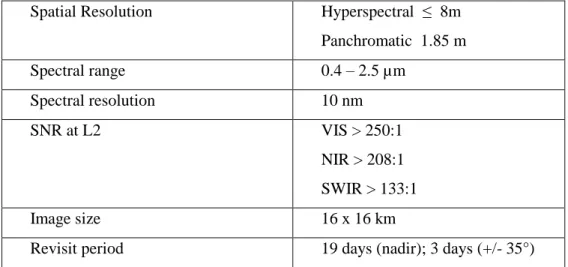
Table 1 – Summary of mission requirements as of end of pre-phase A, based on seven Science and Defence user groups and updated at the beginning of phase A through various surveys. These numbers were to be refined during phase A.
Spatial Resolution Hyperspectral ≤ 8m
Panchromatic 1.85 m Spectral range 0.4 – 2.5 µm Spectral resolution 10 nm SNR at L2 VIS > 250:1 NIR > 208:1 SWIR > 133:1 Image size 16 x 16 km
REFERENCES
[1] J.S. Pearlman, P.S. Barry, C.C. Segal, J.Shepanski, D. Beiro, and S.L. Carman, “Hyperion, a space based imaging spectrometer”, IEEE
Trans. Geosci. Remote Sensing, 41 (6), pp. 1160-1173, 2003.
[2] R.L. Lucke, “Hyperspectral Imager for Coastal Ocean (HICO): instrument description and first images”, Applied Optics, vol. 50, pp.1501-1516, 2011.
[3]M.E. Schaepman, S.L. Ustin, A.J. Plaza, T.F. Painter, J. Verrelst, S. Liang, “Earth system science related imaging spectroscopy – An assessment”, Remote Sens. Environ., 113(1), pp.123-137, 2009.
[4] H. Kaufmann, K. Segl, S. Chabrillat, S. Hofer, T. Stuffler, A. Müller et al., “EnMAP hyperspectral sensor for environmental mapping and analysis”, Proceedings IGARSS, Denver, pp. 1617-1619, 2006.
[5] T. Matsunaga, A. Iwasaki, S. Tsuchida, J. Tanii, O. Kashimura, R. Nakalura, H. Yamamoto, and T. Tachikawa, “Current status of Hyperspectral Imager Suite (HISUI)”, Proc. IGARSS 2013, Melbourne, Australia, 21-26 July 2013.
[6] C. Galeazzi, G. Varacalli, F. Longo, E. Lopinto, L. Garramone, and R. Capentiero, “Overview of the PRISMA mission”, Proc. 6th
EARSeL SIG Workshop on Imaging Spectroscopy, Tel Aviv, Israel, 2009.
[7] Groupe de Synthèse Hyperspectral, “Synthèse sur l’imagerie hyperspectrale”, CNES strategic documentation,2008.
[8] Y. Knyazikhin, M.A. Schull, Y. Yang, P. Stenberg, M. Mõttus, and M. Rauiaunen, “Hyperspectral remote sensing of foliar nitrogen content”, PNAS, 110, E185-E192.
[9] H.M. Pereira et al., “Essential biodiversity variables”, Science, 339(6117), pp. 1160-1173, 2013.
[10] W. Heldens, U. Heiden, T. Esch, E. Stein, A. Müller, “Can the future EnMAP mission contribute to urban applications? A literature survey”, Remote Sensing, 3, pp.1817-1846, 2011.
[11] H.Z.M. Shafri, E. Taherzadeh, S. Mansor, R. Ashurov, “Hyperspectral remote sensing of urban areas: an overview of techniques and applications”, Research J. Applied Sciences, Engineering and Technology, 4(11), pp. 1557-1565, 2012.
[12] S. Michel, M.J. Lefèvre-Fonollosa, S. Hosford, “HYPXIM – an innovative spectroimager for science, security and defence”, Proc.
Hyperspectral Workshop, ESA SP-683, Frascati (Italy), 17-19 March 2010.
[13] M.J. Lefèvre-Fonollosa, P. Gamet, S. Michel, “HYPXIM, an advanced hyperspectral satellite for environment, security and defence”,
XIIth ISPRS Congress, 25 August – 1 September 2012, Melbourne, Australia, http://www.isprs2012.org/abstract/1770.asp, 2012.
[14] V. Carrère et al., “The French hyperspectral EO mission HYPXIM – A second generation high spectral and spatial resolution imaging spectrometer”, Proc. IGARSS 2013, Melbourne, Australia, 21-26 July 2013.
[15] PASO, “Rapport final de l’étude PASO HYPXIM – Système hyperspectral pour les geosciences et les applications duales de Sécurité et Défense”, CNES Project internal report, 2009.
View publication stats View publication stats