Weathering pattern of Messinian Lithothamnium limestones: implication about paleoclimatic conditions
Meriem L. MOULANA1,4, Meriam EL OUAHABI2, Frédéric BOULVAIN3,
Mostefa GUENDOUZ4 & Aurelia HUBERT-FERRARI1
1 Department of Geography, University of Liege, Allée du VI Août 2, 4000 Liège, Belgium 2 UR Clay, Sediment Geochemistry and Environment (AGEs), Department of Geology, Agora Quarter, Building B18, Allée du VI Août, 14, Sart-Tilman, University of Liège, B-4000, Belgium.
3 Sedimentary Petrology, University of Liege, B20, Agora Quarter, Allée du VI Août, 12, 4000 Liege, Belgium.
4 Faculty of Earth Sciences, Geographical and Territorial Planning, University of Science and Technology Houari Boumediene, (USTHB), El Alia, BP 32, Bab Ezzouar, 16111 Algiers, Algeria.
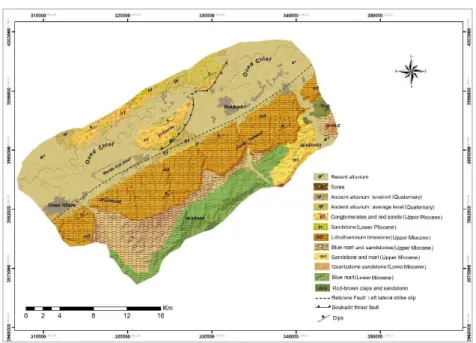
Limestones are prevalent in Algeria. These formations have been affected by a range of weathering, dissolution and recrystallization processes since their deposition, dependant of the paleoclimatic conditions they sustained. These transformations also affect the potential hazard that these karstic terrains represent. We focus here on the Boukadir Region situated at the foot of the Ouarsenis Mountain (Fig. 1). The region comprises the Ouarsenis northern piedmont composed of ~15o north dipping lithothamnium limestones of the Messinian period that rest
unconformably upon blue marls of the upper Miocene, and to the south the E-W striking lower Chlef Basin filled by Pliocene-Quaternary sediments and flooded by the Chlef River. The Lithothamnium carbonates rocks form a major deep aquifer in the basin. The basin is crossed along its southern edge by the Relizane strike-slip fault. In June 1988, there was a large collapse sinkhole of 60 m in diameter and 35 m deep that occurred along the national road RN4 near the southern edge of the basin (Ourabia & Bennallal, 1989). Drilling shows that the sinkhole can be associated to Lithothamnium limestones that were covered by more than 61 m of sediments at that location. No other sinkhole formed since this accident.
In this study we investigate the weathering pattern of the Lithothamnium limestones to unravel the likelihood of the development of large sinkholes in this formation. Boreholes and quarries show that the Messinian calcareous limestones of the Boukadir region are deeply weathered and partly recrystallized; the weathering affects its entire thickness, reaching a maximum of 200 m. This weathering pattern is not visible a few kilometres more to the east, in limestones having a similar origin.
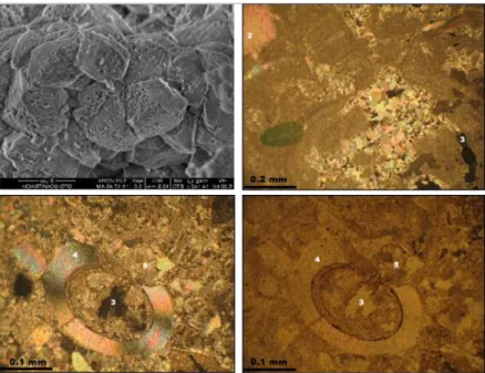
To unravel the specific paleoclimatic conditions that these limestones sustained, we combine field work and on selected samples, petrographic thin section and mineralogical (XRD) analysis and SEM observations. Field work in quarries and in the wadi shows that the Lithothamnium limestones are composed of altering sandstone-rich beds with a calcareous cement and bioconstructions-rich beds. In addition, there is a marked difference between, at the surface, the dense recemented limestone carapace (calcrete) with a thickness reaching 4 m in the quarries and the calcareous tuff below. The formation of this calcrete top layer, is a common feature in the Mediterranean area and can be related to Quaternary climates in the region. At the surface, dissolution features and meters scale open caves are visible. In the calcareous tuff in the quarry, an in depth weathering with recrystallization features and small-scale dissolution conduits are visible. The results of mineralogical (XRD) analysis reveal that Boukadir limestones are mainly calcite with variable amount of quartz and dolomite. The thin sections observations reveal large heterogeneity in the texture, dissolution features, pedogenic structures and micritic recrystallized cement (Fig. 2). Part of this weathering pattern may be attributed to the paleoclimatic conditions that prevailed shortly after the deposition of these carbonate-rich rock at the end of the Messinian Period.
Figure 2. Analyses on Lithothamnium limestones. Top left: Scanning electron microscope (SEM) image showing
weathered calcite crystal; Top right: Thin section (see meaning of numbers below); Bottom: Thin section under polarized light (left) and under reflected light (right). Numbers on thin sections: 1- recrystallization of the micritic cement. 2- calcite. 3- porosity. 4- recrystallized shell; 5- recrystallized planktonic foraminifera.
References
Brives, A., 1911. Explanatory note for the 1: 50,000 geological map of Charon.
Ourabia, K. & Benallal, K., 1989. Report of the collapse of RN4. Central Laboratory of Public Works, 01-03.