Analysis of climate change,
high‐flows and low‐flows scenarios on the
Meuse basin
WP1 report ‐ Action 3
AMICE
Adaptation of the Meuse to the Impacts of Climate Evolutions
is an INTERREG IVB North West Europe Project (number 074C).
Climate change impacts the Meuse basin creating more floods and more droughts. The
river managers and water experts from 4 countries of the basin join forces in this EU‐
funded transnational project to elaborate an innovative and sustainable adaptation
strategy. The project runs from 2009 through 2012. To learn more about the project
visit: www.amice‐project.eu
The NWE INTERREG IV B Program
The Program funds innovative transnational actions that lead to a better management
of natural resources and risks, to the improvement of means of communication and to
the reinforcement of communities in North‐West Europe.
To learn more about the program visit: www.nweurope.eu
Title
Analysis of climate change, high‐flows and low‐
flows scenarios on the Meuse basin
WP1 report – Action 3
Authors
Drogue G., Fournier M., Bauwens A., Commeaux
F., De Keizer O., François D., Guilmin E., Degré A.,
Detrembleur S., Dewals B., Pirotton M., Pontegnie
D., Sohier C., Vaneuville W.
Date
30 – 06 – 2010
Lead partner
EPAMA
Partners involved
UPVM, EPAMA, RWTH Aachen, Rijkswaterstaat,
ULg, Gx‐ABT, Deltares, Flanders Hydraulics Re‐
search
Work package
1
Action
3
INTRODUCTION ... 5
Objectives of the AMICE Project ... 5
Objectives of action 1 and action 3 ... 7
Position of the advanced report in the elaboration of an adaptation strategy for
the Meuse river basin ... 9
1
Presentation of the study area ... 10
1.1
The Meuse river basin ... 10
1.2
Sub‐basins selected for the hydrological impact assessment of climate
change ... 10
1.2.1
The French part of the Meuse basin ... 13
1.2.2
Walloons sub‐basins ... 14
1.2.3
Flemish sub‐basins ... 16
1.2.4
German sub‐basins ... 16
1.2.4.1 Rur basin area ... 17 1.2.4.2 Niers basin area ... 191.2.5
Dutch part of the Meuse basin ... 20
2
Analysis and synthesis of the literature on future climate and hydrological sce‐
narios on the Meuse river basin ... 24
2.1
Presentation of the AMICE TORD ... 24
2.1.1
Structure of the TORD and statistics ... 24
2.1.1.1 Structure of the TORD ... 24 2.1.1.2 Statistics... 262.1.2
Identification of gaps and missing knowledge / promotion of new
studies ... 27
2.2
Future climate scenarios ... 27
2.2.1
Fundamentals on climate scenarios ... 27
2.2.2
Overview of existing climate scenario databases ... 30
2.2.3
Climate projections for the Meuse basin ... 32
2.3
Future hydrological scenarios ... 35
3
Production of future climate scenarios ... 38
3.1
Material and methods ... 38
3.1.1
The delta change approach ... 38
3.1.2
Presentation of the baseline climatology ... 38
3.1.2.1 Partners’ hourly database ... 38 3.1.2.2 Daily E‐OBS gridded database ... 433.1.3
Evapotranspiration Calculation... 43
3.1.4
Selection of climate modeling experiment and scenarios ... 44
3.2
Results of the climate projections for the Meuse basin ... 46
4
Production of future hydrological scenarios ... 51
4.1
Material and methods ... 51
4.1.1
Presentation of the hydrological models ... 51
4.1.1.1 AGYR ... 51 4.1.1.2 GR4J... 51 4.1.1.3 EPICGrid ... 53 4.1.1.4 RS‐PDM ... 53 4.1.1.5 HBV‐96 ... 53 4.1.1.6 NASIM ... 544.1.2
Calculation methods applied to the Hydrological Impact Variables
(HIV) ... 55
4.2
Results of hydrological simulations ... 61
5
Selection of hydrological scenarios ... 64
6
Outlook ... 65
References ... 66
INTRODUCTION
Objectives of the AMICE Project
Climate change experts are increasingly pointing‐out the possible consequences of global warming (IPCC). It is clear that reduction of the emissions is not enough and that we also have to adapt to expected changes, as opposed to waiting until impacts are irreversible. Conse‐ quences of climate change on river basins can be potentially catastrophic. Floods are the main hazard, whereas droughts and low‐flows are a newer threat, conditioned both by climate change and an increased water demand. Adaptation is necessary if we are to maintain our living standards and remain competitive.
Recently, climate change and its impact on water management have been put high on the agenda in the EU: Green Paper on climate change, Communication on Water Scarcity and Droughts, Floods Directive (2007/60/EC), Meeting of the Water Directors, etc. The goals are clear, and now is the time to start acting at the basin level.
Despite many uncertainties on the future climatic context, especially on extreme events, cli‐ mate models are increasingly reliable and the spatial downscaling of climate model outputs has already produced several regional scenarios. According to the precautionary principle, uncertainty about the damage likely to be incurred should not serve as an argument to delay action.
Water managers from 4 countries of the Meuse basin (France, Belgium, Germany and the Netherlands) have decided to unite forces and knowledge in order to propose an adaptation strategy at the international basin scale.
Each member state has already started developing national adaptation strategies, although they are not easily shared or compared: the climate scenarios are different, the damage costs are evaluated with different methods, the measures enforced by neighbouring countries are not taken into account, etc.
By working together jointly in sharing data and methodologies, it is intended to develop a transnational strategic response to the impacts of climate change to the benefit of all the regions covered by the Meuse basin. Transnational cooperation will also facilitate the devel‐ opment of a "basin culture", both between water managers and the population, and increase solidarity.
We created the ‘AMICE’ Project: Adaptation of the Meuse to the Impacts of Climate Evolu‐ tions. The Project receives financial support from the European ‘INTERREG IV B’ Program as well as from the Meuse basin’s Member States and Regions. It will last 4 years (2009‐2012) and is coordinated by EPAMA. The 17 AMICE Partners are: In France: • EPAMA (Etablissement Public d’Aménagement de la Meuse et ses Affluents), respon‐ sible for flood prevention and protection on the French Meuse
• CEGUM (Centre d’Etudes Géographiques de l’Université de Metz), Center for geo‐ graphical studies, the University of Metz
• CETMEF (Centre d’Etudes Techniques Maritimes et Fluviales), technical center for inland and maritime waterways
• Région Wallonne – GTI (Groupe Transversal Inondations), the cross‐disciplinary work‐ ing‐group on floods in the Walloon Region
• Gembloux Agro‐Bio Tech, the department of Hydrology and Hydraulic Eng., University of Liege.
• ULg – HACH, the department of Hydrology, Applied Hydrodynamics and Hydraulic Constructions of the University of Liège • APS (Agence Prévention et Sécurité), the regional agency for overall prevention and security • Community of Hotton In Belgium (Flanders): • nv De Scheepvaart, manager of the channels for water transport and drink water pro‐ duction
• Waterbouwkundig Laboratorium, the research center for hydraulic sciences in Ant‐ werp • Vzw RIOU, association for communication and renaturation In Germany: • WVER (Wasserverband Eifel‐Rur), manager of the Rur tributary • RWTH Aachen Universität ‐ Lehrstuhlund Institut für Wasserbauund Wasserwirtschaft: the institute of hydraulic engineering and water resources management • RWTH Aachen Universität ‐ Lehr‐und Forschungsgebiet Ingenieurhydrologie: the aca‐ demic and research department engineering hydrology In the Netherlands:
• Rijkswaterstaat, Ministry of Transport, Public Works and Water Management is in‐ volved through two of its departments: Waterdienst and Limburg • Waterschap Aa en Maas and • Waterschap Brabantse Delta, water authorities in the Province of Noord‐Brabant, wa‐ ter managers of the sub‐basins among the 5 of the Meuse basin in the Netherlands. The aims of AMICE are to: 1) Develop a basin‐wide climate adaptation strategy, coordinated transnationally, and focused on water discharges and the functions influenced by them. The strategy development will take into account climate scenarios, on‐going projects, existing measures and the EU Floods Direc‐ tive (2007/60/EC), with a particular focus on floods and low‐flows. 2) Realize a set of measures against low‐flows and floods, profitable for the international basin of the Meuse and that can be used by other river basins in Europe.
3) Reinforce and widen the partnership between stakeholders of the Meuse basin, and in‐ crease the exchange of knowledge and experience on prevention, preparedness and protec‐ tion against flood and drought risks.
4) Engage the local population and stakeholders by improving their understanding of climate change, sustainable development, basin functioning, risk consciousness of water hazards and the sense of belonging to a common river basin, across administrative and language borders.
Studies have already been undertaken relating to future climate change, synthesized in ‘The impacts of climate change on the discharges of the river Meuse’, 2005, International Meuse Commission.
‐increased frequency of floods in winter, extreme events in particular,
‐increase in low‐flows, more likely the result from higher water demand than higher air tem‐ peratures,
‐need to agree on common scenarios, jointly examine the effect of an improved coordination of water management policies.
The transnational cooperation will result in basin‐wide scenarios on climate change and dis‐ charges, used as input for the adaptation strategy. The Project is divided into 5 Work Packages (WP) (Figure 1). The present report is part of WP1. Figure 1 : AMICE project organization chart
Objectives of action 1 and action 3
AMICE’s Work Package 1 is dedicated to the impacts of future floods and low‐flows on the Meuse basin. Partners will perform a technical and scientific analysis of climate‐change‐ induced floods and low‐flows through prospective modeling, efficiency evaluation of water management measures, damage calculation, and proposition of solutions.
Scenarios of the future climate are already exchanged by i.e. Meteorological offices and Re‐ search institutes in FP6 and FP7 projects, but many others need to be shared, especially re‐ garding the borderless question of climate evolutions. There is no point in developing complex techniques if the outputs cannot be shared with the neighbour specialists. The AMICE project provides the opportunity to use common scenarios, tools and methods to evaluate measures and elaborate strategies that can finally be comparable between countries. The present report details methods and results from Actions 1 and 3 which have been carried‐ out in 2009 and supervised by the University of Metz.
Action Reference Partner J F M A M J J A S O N D J F M A M J J A S O N D J F M A M J J A S O N D J F M A M J J A S O N D Workpackage 1 : Risk assessment
common database Metz University
maps Wallon region (GTI)
scenarios of climate change and hydrology Metz University hydraulic simulation of the Meuse Liege University impacts of future floods and low-flows Aachen University "climate-proof" of existing and new measures Flanders Hydraulics strategy of adaptation Rijkswatertstaat
research reporting m eeting communication 2012 AMICE 2009 2010 2011 1 : Bibliography 2 : Mapping 3 : Hydrological modeling 4 : Meetings 5 : Reports 6 : Hydraulic modeling 7 : Impact assessment 8 : Climate check 9 : Adaptation strategy Table 1. AMICE Workpackage 1 organization chart Action 1 description: The objective is to share our knowledge on the present and future characteristics and hydro‐ logical behaviour of the Meuse river basin.
Knowledge on this topic is still scattered and hardly available within the 3 official languages spoken on the Meuse basin. Information has been gathered by the Partners, translated into English, French, Dutch or German when required and organized by topics into an online data‐ base.
Action 3 description:
This Action is dedicated to the study of downscaled climate simulations for 2020‐2050 and 2070‐2100 and their consequences in terms of floods and low‐flows on the Meuse river basin. The following questions will be answered:
‐ which discharges can be expected on the river Meuse and main tributaries?
‐ how the return period, duration, extent of floods and low‐flows will change from now to 2020‐2050 and 2070‐2100?
Partners have analyzed climate simulations from meteorological institutes (IPSL, Cerfacs, KMI, KNMI, ...), national and EU research programs (Prudence, Ensembles, ADAPT, etc): bibliogra‐ phies, interviews of users, experts invited to meetings. They have checked if they can be ap‐ plied to the Meuse basin, assess their uncertainty and the required corrections. New production or acquisition of climate data was not carried‐out because: ‐ The project is more oriented on climate change consequences rather than on its causes, ‐ The length of the project is insufficient for running new meteorological simulations, ‐ There are existing scientific publications and data that can be used to document the issue.
Position of the advanced report in the elaboration of an adaptation
strategy for the Meuse river basin
The Partners involved in the above‐mentioned actions achieved the basis research that will be used throughout the AMICE project. The climate and hydrological scenarios will not only be used for WP1 but also for some investments in WP2 and WP3, as well as for the definition of the transnational exercise in WP4. The present report details the hypotheses that were made and the knowledge used to define the climate scenarios for the Meuse basin. It is thus extremely important to emphasize that the AMICE adaptation strategy will respond to two climate scenarios (a wet and a dry ones) – the most reliable we could find but not the only possible ones – with their assumptions and uncertainties. These climate scenarios repre‐ sent what could, most likely, happen on the Meuse basin.
1 Presentation of the study area
1.1 The Meuse river basin
The Meuse river basin is one of the most densely populated areas of Western Europe and a major geographic link between Belgium, France, Germany, Luxembourg and the Netherlands. The river itself is navigable and provides drinking water for more than 5 million inhabitants. The main characteristics of the Meuse Basin are (De Wit et al., 2007): Length : 900 km Drainage area : 35.000 km² Number of inhabitants : 9 millionIts discharge fluctuates considerably with seasons: it reached 3000 m3/s in winter 1993 in Liege and can be as low as 10‐40 m3/s in the summer season. Classed as a rain‐fed river, it has no glacier and little groundwater storage capacity to buffer precipitations. Most of the water comes from the Walloon tributaries in the Ardennes.
A direct link exists between climate evolutions/change and changes in high and low‐flows, putting at risk the assets of the basin, including major infrastructures, industries, priceless historical and ecological heritage. The 5 European countries are working together in the International Meuse Commission (IMC), created in 2002 to coordinate the application of the Water Framework Directive (2000/60/CE). The Commission will now coordinate the application of the EU Flood Directive (2007/60/CE).
1.2 Sub‐basins selected for the hydrological impact assessment of cli‐
mate change
Figure 2 presents a map of gauging stations selected by the Amice partners for the hydrologi‐ cal simulations. Nine stations were chosen within the Meuse basin (Table 2): • Four stations on the French part of Meuse • One at the Walloon/Netherlands border. • Four stations on Walloon and German right‐side tributaries located on the Lesse, the Vesdre, the Niers and the Rur rivers. For practical reasons (short delay, existing models calibration, etc) it was not possible to take into account others stations. For each selected station, hydrological simulations were realized in order to estimate the evolution of high‐flows and low‐flows discharges during the 21st cen‐ tury (2021‐2050 and 2071‐2100).Table 2. Main characteristics of gauging stations selected for the Amice project. *De Wit et al. (2007)
Station
(km2) charge data tributaries confluence
with the Meuse (km)* formation use
discharge value in high flows value in low flows ence on natural flows Meuse Saint‐Mihiel 2540 http://www.hydro.e aufrance.fr/ ‐ Mesozoic Forest & Agriculture 596 m³/s ‐ ‐
Meuse Stenay 3904 http://www.hydro.e
aufrance.fr/ 298 Mesozoic Forest & Agriculture 600 m³/s ‐ ‐ Meuse Montcy‐Notre‐ Dame 7724 http://www.hydro.e aufrance.fr/ ‐ Mesozoic Forest & Agriculture 960 m³/s ‐ Agriculture Meuse Chooz 10120 http://www.hydro.e aufrance.fr/ 477 Mesozoic Forest & Agriculture 1610 m³/s ‐ Nuclear plant Lesse Gendron 1284 SETHY 505 ‐ Forest 390.8 m³/s 0.6 m³/s ‐ Vesdre Chaudfontaine 683 SETHY 597 ‐ Forest 274.5 m³/s 0.2 m³/s dams Meuse Sint Pieter 20.200 KNMI 631 Mesozoic Forest 3039 m3/s < 20 m3/s Important water diver‐ sions to upstream channels, water use by agriculture, industry and households
Rur Stah 2135 LANUV NRW 694
Unconsolidated rock (north) consolidated rock (south) Arable land 129 m³/s (27.5.1983) 8.1 m³/s (15.07.1996) Reservoirs Lowering of groundwa‐ ter table Admissions of water
Niers Goch 1203 LANUV NRW 771 Unconsolidated
rock Arable land 42,4 m³/s (7.12.1960) 1,2 m³/s (24.08.1976) Lowering of groundwa‐ ter table Admissions of water
Mapping portal
The Géoportail (Ministère de l’écologie, de l’énergie, du développement durable et de la mer, IGN, BRGM) gives access to a lot of dynamical maps, regularly updated : http://www.geoportail.fr/
1.2.1 The French part of the Meuse basin
The French basin is located upstream of the transnational basin (Figure 3). It is oriented from the south to the north and can be divided into two parts:
‐ The first part extends from the source, on the plateau de Lan‐ gres (384m above sea level) to Verdun. This area is very elon‐ gated because the basin is limited by the Côtes de Moselle in the east and the Côtes de Meuse in the west. Agriculture is dominant in this region. ‐ The second part includes the French Ardennes and presents higher altitudes (400‐500 me‐ ters). The orographic effect we can observe in this area results in more precipitations than in the south (>1000mm/y). There are few medium‐sized cities like Verdun (20.000 inhabitants), Sedan (20.000), and Charleville‐ Mézières (100.000). This area is predominantly forested.
The climate of the French sub‐ basin is semi‐oceanic: rainfalls are fairly regular throughout
the year (approximately
80mm/month). The hydrologi‐ cal regime is unimodal (only one low flows period each year in summer, and one high flows period in winter). The French part covers approximately one third of the whole Meuse basin in terms of surface, length, and mean annual flows. Flows of the French part of Meuse are mainly conditioned by the amounts of precipitation and potential evapotranspiration (PET). Transnational basin French sub‐ basin Surface 33.000 km² 10.120 km² Length 950 km 355 km Average discharge 350 m3.s‐1 148 m3.s‐1 Figure 3. French sub‐basin of the Meuse
1.2.2 Walloons sub‐basins
The Meuse reaches Belgium at the Heer’s level. It runs through the Ardennes via the Fagnes in the Province of Namur where it successively receives the Lesse and the Sambre in the city of Namur. It runs through the Province of Liège where it receives the Houyoux close to Tihange and the Ourthe at Liège. The Meuse leaves the Walloon Region at Visé. After a turn in the Netherlands via Maastricht, it acts as a border between Belgium and the Netherlands in the Province of Limburg. It runs through Maasmechelen and Maaseik before leaving Belgium.
In the Walloon Region, the Meuse sub‐basins are (Figure 4): Meuse‐aval, Sambre, Meuse amont, Lesse, Vesdre, Ourthe, Amblève and Semois‐Chiers. One third of the Meuse river basin area is located in the Walloon Region, let approximately 12000 km²
(Ashagrie et al., 2006).
Climate of the Meuse basin in Walloon Region Belgium has a maritime, wet temperate climate due to its latitude and its proximity to the sea. Air temperatures are moderate with a yearly mean of 10°C. Prevailing winds blow from South‐ West and West sectors. Cloud coverage is important and rain is common and regular, weak snowfall can be observed in the Ardennes.
Between the south and the north of the country, difference in air temperature are weak in summer but more pronounced in winter due to an hilly relief in the south. Concerning rainfall, the Semois valley and the Hautes‐Fagnes receive about 1.400 mm per year whereas the centre and north of the country receive less than 800 mm per year. Usually, all Ardennes receive more rainfall. There, it rains for about 200 days a year, against 160 to 180 days in the centre
(Ministère de la Région wallonne, Direction Générale des Ressources naturelles et de l’Environnement, Observatoire des Eaux de Surface, Direction des Eaux de Surface Direction des Eaux souterraines, 2005)
.
Ourthe Lesse Sambre Meuse aval Meuse amont Ambleve Semois-Chiers Vesdre Meuse aval´
0 10 20 40 60 80 Kilometers Figure 4. Walloons sub‐basins of the MeuseSoils
The main soils associations for the Walloon basin of the Meuse are stony loam soils, loamy soils, slightly stony loam soils, loamy sand soils (Figures 5 and 6).
Figure 5. Distribution of the main soils associations for the Meuse river basin in Wallonia.
Source: Ministère de la Région Wallonne, Direction Générale des Ressources naturelles et de l'Environnement, 2002.
Figure 6. Pedology in Walloon Region.
Source: Ministère de la Région wallonne, Direction gé‐ nérale des Ressources naturelles et de l'Environnement, 2002.
Land‐uses Land‐uses of the Meuse river basin in the Walloon Region are constituted by 25% of grassland, 24% culture, 18% deciduous forest, 18% coniferous forest. Urban area covers 7% of the terri‐ tory. (Figure 7)
Figure 7. Land uses for the Meuse river basin in Walloon Region.
Source: Ministère de la Région Wallonne, Direction générale des Ressources naturelles et de l'Environnement, 2002.
Mapping portal
‐ The Walloon Region gives access to a lot of dynamical maps, regularly updated : http://cartographie.wallonie.be ‐ Geological maps are viewable at the address : http://environnement.wallonie.be/cartesig/cartegeologique/
1.2.3 Flemish sub‐basins
Compared to the total area of the Meuse basins, the Flemish part is relatively small and hydro‐ logic models covering the whole international Meuse basin already exist in the Netherlands. The Dutch delegation of the International Meuse Commission brought researchers at FHR and Deltares together and a study to calculate the 3 Belgian climate change scenarios for hydro‐ logic impact with the models from Deltares was ordered by FHR.1.2.4 German sub‐basins
The following tables 3 and 4, give an overview of the size of the basin area and the mean discharge at lower reaches of the German tributaries to the Meuse. It can be stated, that Rur and Niers have for both aspects a higher order of magnitude than all other German tributaries together. For the mentioned reasons we share the opinion that Rur and Niers are the decisive German tributaries to the Meuse and we think that it is thus justified to take only Rur and Niers into consideration for the present study.
Table 3. Basin areas and percentage of Meuse basin for main German tributaries to the Meuse (values taken from
(
MUNLV, 2005‐1))
Basin area [km²] percentage of Meuse basin [%] Meuse 34.548 Rur 2.338 6,77 Niers 1.382 4,00 Schwalm 273 0,79 other northern Meuse inflows 158 0,46 other southern Meuse inflows 129 0,37Table 4. Mean discharges at lower reaches for Rur, Niers, Schwalm (values taken from
(
MUNLV, 2005‐1))
mean discharge at lower reaches [m³/s] Meuse Rur 22,71 Niers 7,79 Schwalm 1,661.2.4.1 Rur basin area
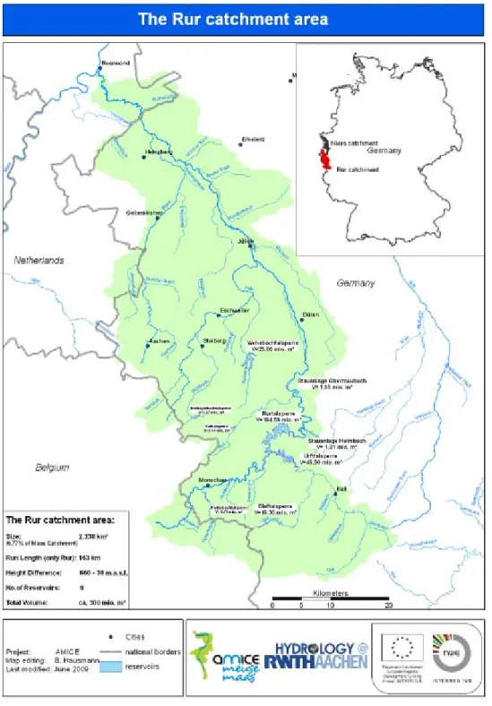
The Rur basin area covers parts of Germany, Belgium and the Netherlands. With 89%, the majority of the area is located in Germany. The headwaters are located in Belgium, the estuary in the Netherlands with the outlet into the Meuse at Roermond (NL). In Figure 8 an overview is given.
The Rur has a run length of 163 kilometers of which 10 kilometers are located in Belgium, 132 in Germany and 21 in the Netherlands. The main tributaries are Urft for the upper reaches, Inde for the middle reaches and Wurm for the lower reaches. The size of the basin area is 2.338 km². The average total annual precipitation is 855 mm (MUNLV, 2005‐1).
The basin area is divided into two totally different landscape‐regions. The southern part of the basin area with mostly consolidated rock belongs to the Rhenish Massif. Its northern border is in line with the cities of Aachen, Eschweiler and Düren. The area northern of this line with mostly unconsolidated rock is part of the Lower Rhine lowlands. This area is intensively used for the recovery of drinking‐ and industrial water.
For the German parts of the basin area the main land use categories are arable land (approx. 30%), grassland (approx. 20%) and forests (approx. 30%). But they are not homogeneously distributed over the basin. Settlement areas take about 10% of the German part of the basin area. Most of them are lying right beside the major rivers and cover partly wide parts of the former floodplains. Another important land‐use is the open pit mining. Although the percent‐ age is low it has great impacts due to the necessary rearrangement of the area and the exten‐ sive lowering of groundwater. Within the Netherlands the area is mostly used for agriculture. In the Belgian part of the basin area there is, with 57%, a great percentage of forests. The agricultural area is, with 25%, lower than in the Netherlands (MUNLV, 2005‐1).
The discharge behaviour is heavily influenced by the nine reservoirs in the Eifel and the ap‐ proximately 50 flood control basins. Further influences are the river development with stan‐ dard sections and water management structures and extractions and discharges.
Figure 8. Overview over the Rur basin area
The nine reservoirs have a total storage volume of about 300 million m³. They serve among other purposes for drinking water supply, flood control, low‐flows enrichment, power genera‐ tion or recovery. For the optimization of the water resources management the reservoirs in the upper Rur reaches including Urft and Olef are operated in a linked system.
Within the middle and lower reaches of the Rur there are many admissions of municipal or industrial clarification plants. The settled areas cause increased surface runoff and the rivers are stressed by combined wastewater or rainwater admissions.
The Rhenish brown coal mining area covers parts of the Rur basin area. To mine the brown coal in open pits it is necessary to lower the groundwater table by draining the mines. The
effects of this lowering go beyond the Rur basin area. About 50% of this draining water is used for water supply, the other part is within the Rur basin area mainly discharged into the Inde. By these interventions the water balance of the area with unconsolidated rock has been heav‐ ily influenced since the 1950s. This influence will remain in the next decades. The end of the open pit mining in the Rur basin area is aimed for about 2030 (MUNLV, 2005‐1). For the mining area “Inden” it is planned to create a lake by filling the remaining pit with water. For this sev‐ eral strategies concerning the details of the filling are discussed.
1.2.4.2 Niers basin area
The Niers basin area covers parts of Germany and the Netherlands. The estuary is in the Neth‐ erlands with the outlet into the Meuse at Gennep (NL). In Figure 9 an overview is given. The Niers has a run length of 118 kilometers of which 8 kilometers are located in the Nether‐ lands. The total size of the basin area is 1.382 km². The average total annual precipitation is 708 mm (MUNLV, 2005‐2).The Niers can be divided into three parts. The upper Niers with its main tributary Gladbach reaches until gauge Trabrennbahn. This area is mainly influenced by the brown coal mining and the associated lowering of the water table. As adjustments there are several admissions of draining water into the rivers or into wetlands. The discharge behaviour is impressed by the surface runoff from the city of Mönchengladbach.
The middle Niers with the main tributaries Nette, Cloer and Gelderner Fleuth reaches until gauge Geldern. This part is influenced by the sewage treatment plant Mönchengladbach‐ Neuwerk.
The lower Niers is impressed by the agricultural area of the environment. Main tributaries are Issumer Fleuth and Kervenheimer Mühlenfleuth.
The basin area of the Niers is impressed by unconsolidated rock and is part of the Lower Rhine lowlands. Particularly in the north‐west of Mönchengladbach (near Krefeld) are many facilities for the recovery of drinking water. Besides the water bodies are partly area‐wide used for industrial purposes.
In the German part of the Niers basin area the land use is dominated by agricultural and silvi‐ cultural purposes. About 50% of the area is used as arable land. Grassland and silvicultural areas make 15% each of the basin area. In the Dutch part of the basin area the distribution of land use is comparable to the one in Germany (MUNLV, 2005‐2).
The discharging of the admissions of municipal or industrial sewage treatment plants is an important task for the rivers in the basin area of the Niers. There are many admissions from combined wastewater or rainwater.
Due to the very flat topography in the basin area flood control measures are necessary. The retention is done, besides the natural one within the floodplains, via regulated flood retention basins. Dikes along the rivers ensure the flood protection for small and middle size flood events (MUNLV, 2005‐2).
Figure 9. Overview over the Niers basin area
1.2.5 Dutch part of the Meuse basin
The Dutch part of the Meuse basin counts with 3,5 million inhabitants and has a surface area of 7.700 km2. The Dutch Meuse is the last stretch of the Meuse River where after around 250 horizontal kilometres and 45 vertical meters from the Dutch‐Belgium border it drains into the North Sea. Several large cities are situated next to or close to the Meuse river, such as Roer‐ mond, Venlo, Nijmegen and ‘s‐Hertogenbosch.
Most of the land surface in the Dutch Meuse basin is used for agriculture: about 550.000 ha or 70% (Internationale Maascommissie, 2005). About 15% of the surface has a nature function. Recreation, urban areas and industry also occupy about 15% of the land surface of the Meuse basin. However, urbanization, transport, industry and agriculture increasingly take more space in the basin. The southern part of the basin is relatively open (lower rates of urbanization etc.).The percentage of open water is limited (Arcadis, 2007).
The Meuse basin represents about 22% of the national production value and is of great impor‐ tance for the Dutch industry. Sand and gravel is excavated from some parts of the basin. In‐ tensive animal husbandry and mixed farms (both agriculture as well as cattlebreeding) are strongly represented. Especially in the province of Noord Brabant intensive animal husbandry has increased. Near the mouth of the Meuse, salinification has a negative impact on agricul‐ ture (Arcadis, 2007).
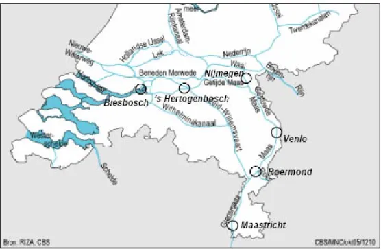
The Meuse enters the Netherlands at Eijsden, south of Maastricht (Figure 10).Historically, the discharge is measured at Borgharen, a small town just north of Maastricht. Currently, dis‐ charge is measured at St. Pieter as morphology downstream is being changed by the Maaswerken project. From Eijsden to Borgharen, the Meuse is called “Upper” Meuse (Boven‐ maas). At Borgharen, the Meuse water is divided over the “Border” Meuse (Grensmaas), which forms the natural border with Belgium for about 40 km, and the Julianakanaal next to it. Note that the Julianakanaal is not shown in Figure 10. The Julianakanaal has been constructed for navigation, and most of the navigation towards Belgium occurs through this canal. Near Roermond, the Julianakanaal and the Meuse join again, to be divided over the Zuid Willems‐ vaart (which cuts off part of the original Meuse, see Figure 11) and the Meuse, which are both navigable. At Mook (near Nijmegen), the Meuse bends towards the west, and a canal through Nijmegen connects the rivers Waal and Meuse. The river continues to flow as one stream to Heusden, near ‘s Hertogenbosch. In older days, the Meuse split into two streams here. Today, the con‐ nection with the Merwede is closed and the Meuse as a whole flows via the Bergsche Maas and the Amer through the natural park Biesbosch towards the Northsea. Figure 10. The Meuse in the Netherlands
Several (small) tributary streams join the Meuse in the Netherlands. The main ones are the Jeker, Voer, Geul, Roer, Niers, Dieze, Dommel and Aa. Important canals that are fed by the Meuse are Zuid‐Willemsvaart, Wilhelminakanaal and Julianakanaal. Table 5. The most important subcatchments of the Meuse in the Netherlands and their surface areas. Note that some subcatchments areas are partly situated in Belgium (B) or Germany (G) and therefore the sum of the catchments is larger than the Meuse basin area in the Nether‐ lands. Source table: Ministerie V&W, 2005
Weirs have been constructed along most of the Meuse to facilitate shipping; the only non‐ navigable part of this river is the southernmost part, the Grensmaas. Here, the Meuse mean‐ ders over shallow gravel banks; there are no weirs and the river flows swiftly at times of high discharge. Shipping goes along the Julianakanaal, which runs parallel to the Grensmaas. At Roermond, large lakes have been formed following gravel dredging. During the course of the years, the Meuse has cut increasingly deeper into the surrounding country between Cuijk and the Belgian border, resulting in a step‐like terraced landscape in which the top terraces are the oldest river beds. This is a unique landscape by Dutch standards due to the vast differences in height. Old villages are situated at the transition point between low terraces and central ter‐ races. No dykes are required here, since the banks are naturally high. Following the river downstream from Cuijk, the Meuse valley becomes a plain where both Meuse and Rhine have left sediment deposits. At this point, the river flows through high natural levees and low‐laying sedimentary basins; this part of the river has been embanked. The major bed has levelled up rapidly since the dykes were constructed, so that the floodplains are currently situated at a much higher level than the surrounding area. The water pursues its course to the sea through the Bergsche Maas and the Nieuwe Waterweg; it also flows through the Haringvliet at times of high discharge (Liefveld, W.M & Postma, R., 2007: Two rivers: Rhine and Meuse). The Rhine‐Meuse estuary Rhine and Meuse meet at the Rhine‐Meuse estuary. Here, water levels are mainly determined by sea tides and to a considerably lesser extent by river discharge. Tidal influence runs through the entire course of the Nieuwe Waterweg. This influence is already noticeable in the river’s downstream sections at Hagestein (Lek), Zaltbommel (Waal) and Lith (Meuse). At high tide, salt water enters the Nieuwe Waterweg, and travels as far as Dordrecht when the river dis‐ charge is low. If high sea tides coincide with low water discharges, this salt water can even reach the Haringvliet and the Hollandsch Diep (Liefveld, W.M & Postma, R., 2007: Two rivers: Rhine and Meuse).
Figure 11. Schematic overview of the Dutch Meuse and its tributaries (Ministerie V&W, 2005)
At the Rhine‐Meuse estuary, the Haringvliet sluices constitute the regulating cock for the distribution of discharge among the various tributaries. During times of average discharge, most of the river water flows to the sea through the Nieuwe Waterweg. A small part flows into the sea via the Haringvliet, where the river water reaches the North Sea at low tide through the 17 discharge sluices in the Haringvliet dam. When discharge is high, the sluices open still wider, and more river water ultimately flows out through the Haringvliet than through the Nieuwe Waterweg. With a Rhine discharge of approximately 9000 m3/s, the sluices are com‐ pletely open at low tide, while at high tide, they are always closed to prevent salt water from flowing into the Haringvliet. This transition area from river to sea consists of a tangle of water‐ courses. At low tide, the small banks, with their characteristic reed lands, are dry. The Bies‐ bosch used to be a unique freshwater tidal area, but these tides have largely disappeared since the damming of Haringvliet and Hollandsch Diep. Despite this, it is still an attractive area with its mud flats, salt marshes, creeks, osier thickets, embankments, agricultural polders and riparian woodlands. The waters of the Rhine‐Meuse estuary flow through low‐lying country that is sometimes way below sea level (Liefveld, W.M & Postma, R., 2007: Two rivers: Rhine and Meuse).
2 Analysis and synthesis of the literature on future cli‐
mate and hydrological scenarios on the Meuse river
basin
2.1 Presentation of the AMICE TORD
The first action of the AMICE project has consisted in the implementation of a tool for sharing bibliographic references in order to pool knowledge. This tool is called AMICE TORD (Transna‐ tional Online Reference Database) and each partner (in particular those involved in the Work Package 1) can view and add references dealing with the Meuse, climate change and other topics of interest to AMICE.2.1.1 Structure of the TORD and statistics
2.1.1.1 Structure of the TORD
The application that was chosen is Wikindx®. One of its advantages is the possibility to create as many user accounts as needed. Visitors can see the references, however a user account is necessary to modify the database and to add or delete publications (Figure 12). In addition to entering basic bibliographic information (title, authors, years...), it is also possi‐ ble to attach files (picture, pdf, doc...) and URL. Queries can be based on keywords, author and publisher by using two search forms available (quick & power search). A system of categories based on issues of the AMICE project has also been developed to refine search (Figure 13). Nine categories were created, comprising 45 sub‐categories. The two firsts categoriespertain
to language (one of the three official languages or English) and geographic area (na‐
tional sub‐basin of the Meuse, Meuse transnational basin, outside of the basin…). The
seven other categories are optional and give information on topics (physiography,
climatology, hydrology, trend analysis, drinking water, water hazard mitigation, water
management system). When entering a new reference, the user can select as many
categories as topics.
Thanks to this system it is possible to refine the researches of bibliographic references
and to have an overview of the most (and least) represented subjects in the AMICE
TORD.
Another feature of Wikindx® is to allow each user to comment on the references by adding new fields as quotes, paraphrases, musings, and comments. Annotated references then enjoy a better visibility. Finally, this software is compatible with the Bibtex (.bib) file format, making it possible to import and export several references at once with Zotero for example (extension for Mozilla Firefox).
Since December 2009, hosting and administration of TORD are insured by the EPAMA and accessible on the official website of the AMICE project (www.amice‐project.eu/biblio).
2. Basin 2.1 Meuse river 2.2 French basin 2.3 Walloon part 2.4 Flemish part 2.5 Dutch part 2.6 German part 2.7 Luxemburgish part 2.8 Adjacent basin 2.9 Outside of the basin
1. Language 1.1 English 1.2 French 1.3 Dutch 1.4 German 3. Physiography 3.1 Geology 3.2 Pedology 3.3 Topography 3.4 Hydrogeology 3.5 Geomorphology 3.6 Land Uses 3.7 Biodiversity 3.8 Water quality 4. Climatology 4.1 General features 4.2 Climate mechanisms 4.3 Statistical and extreme value analysis
4.4 Climatological mapping 4.5 Downscaling techniques
6. Trend analysis
6.1 Historical data series 6.2 Future scenarios
5. Hydrology
5.1 Floods 5.2 Low flows
5.3 Hydrological regime and hydrography
5.4 Hydraulic characteristics of the river bed
5.5 Hydrometry
5.6 Origin of water, natural and artificial water pathways 5.7 Impact of past and future climate changes on hydrology
8. Water hazard mitigation
8.1 Flood control 8.2 Low water supply
8.3 Impacted economic activi-ties 7.1 Drinking water 7.2 Fluvial navigation 7.3 Agriculture 7.4. Hydropower, nuclear plant 7.5. Industries
9. Water management sys-tem
9.1 Flood forecasting 9.2 Low flows forecasting 9.3 Design flood
9.4 Water management ser-vices 9.5 Models inventory Main categories and sub‐categories Optional categories and sub‐categories Figure 13. List of categories and sub‐categories created for the AMICE TORD
2.1.1.2 Statistics
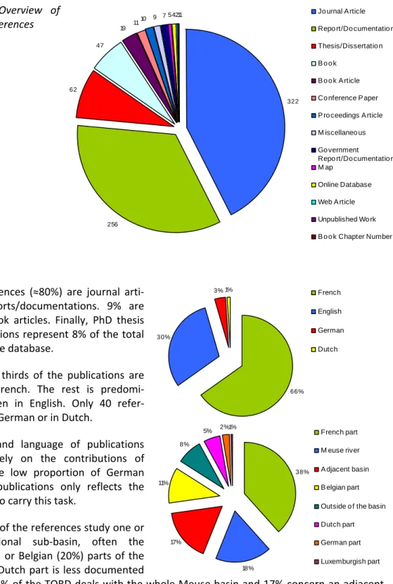
Early 2010, 8 months after its start, the AMICE TORD had about 800 references and more than 1.000 authors (Figure 14).
Figure 14. Overview of the TORD references
‐ Most references (≈80%) are journal arti‐ cles or reports/documentations. 9% are books or book articles. Finally, PhD thesis and dissertations represent 8% of the total content of the database.
‐ About two thirds of the publications are written in French. The rest is predomi‐ nantly written in English. Only 40 refer‐ ences are in German or in Dutch.
The origin and language of publications depend largely on the contributions of Partners. The low proportion of German and Dutch publications only reflects the lack of time to carry this task.
‐ About 60% of the references study one or several national sub‐basin, often the French (66%) or Belgian (20%) parts of the Meuse. The Dutch part is less documented
(only 5%). 18% of the TORD deals with the whole Meuse basin and 17% concern an adjacent basin interesting for the AMICE project because of its proximity (often the Rhine). 8% are considering a further away area (e.g. climate change on another basin in the world) or general topics that can sometimes be transposed to the Meuse (e.g. method of downscaling) The filling and using of the database is an ongoing process. The share between the different topics and languages may evolve with the development of the AMICE actions until 2012. 322 256 62 47 19 11 10 9 7 54211 Jo urnal A rticle Repo rt/Do cumentatio n
Thesis/Dissertatio n B o o k B o o k A rticle Co nference P aper P ro ceedings A rticle M iscellaneo us Go vernment
Repo rt/Do cumentatio n M ap Online Database Web A rticle Unpublished Wo rk B o o k Chapter Number 66% 30% 3% 1% French English German Dutch 38% 18% 17% 11% 8% 5% 2%1% French part M euse river A djacent basin B elgian part
Outside o f the basin
Dutch part
German part
‐ More than one third of the topics cern physiography. Among these publica‐ tions, 20% deals with geology and 12% with climatology (often climate change).
2.1.2 Identification of gaps and missing knowledge / promotion of new studies
The most important study on climate change impacts on the Meuse basin was carried out by De Wit et al., 2007. The conclusions are on the possible increase of extreme events, both high and low flows. But the exact impacts need to be detailed.
In France, no study exists specifically on the Meuse basin. Research institutes have started analyzing the possible effects of climate change, but they are working at the national scale. The diversity of climates in France, with a huge contrast between the Mediterranean region and the North‐East area, calls for more detailed studies. However, the methods developed can be used again in AMICE. The Ministry of Environment has selected the Meuse basin has one of the pilot basins for climate impact studies. The AMICE project will provide methods for the other river basins in France.
To our knowledge no studies concerning the impacts of climate change on the water balance and stream flows have been undertaken specifically for the Rur and Niers basin areas. Such studies have only been carried out for the adjacent sub basins of the Meuse (e.g. (de Wit et al., 2007), (van Pelt et al., 2009)) or the Rhine (e.g. (Pfister et al., 2004), (Middelkoop et al., 2001)). Thus in the framework of AMICE impact studies specifically for the Rur and Niers basin areas will be undertaken for the first time. For the impacts of climate change on the water balance of the Rhine basin area (Gerlinger, 2009) states that there are large regional differences in the simula‐ tion results. Therefore our studies will provide new findings.
2.2 Future climate scenarios
2.2.1 Fundamentals on climate scenarios
The greenhouse gases emission scenarios commonly used in studies of climate change have been developed by the IPCC (Intergovernmental Panel on Climate Change) since 1996 and they have been described in the SRES (Special Report on Emission Scenarios). Four groups of scenarios exist depending on factors determining the emissions of greenhouse gases, their quantity and the evolution of their concentration in atmosphere. A total of forty scenarios consider different possibilities of demographic, economic, and technological evolutions and their impacts on emissions. For each group of scenarios, one scenario of reference has been selected by the IPCC (A1B, A2, B1 and B2) (Figure 15). Thereafter, two other scenarios related to new forms of technological progress have been added (A1FI and A1T). These 6 scenarios are the most used for GCM simu‐ lations and for impact studies of climate change (Figure 16). 39% 21% 12% 8% 8% Hydro lo gy Climato lo gy Drinking water Trend analysis Water management system Water hazard mitigatio n
Figure 15. The four principle IPCC SRES scenarios
Figure 16. Evolution of some GHG during the 21st century (IPCC, 2001).
For example, emission scenarios A2 and B1 are described in the SRES report as follow: A2 : “The A2 storyline and scenario family describes a very heterogeneous world. The underly‐ ing theme is self‐reliance and preservation of local identities. Fertility patterns across regions converge very slowly, which results in continuously increasing population. Economic develop‐ ment is primarily regionally oriented and per capita economic growth and technological change more fragmented and slower than other storylines.”
B1 : “The B1 storyline and scenario family describes a convergent world with the same global population, that peaks in mid‐century and declines thereafter, as in the A1 storyline, but with rapid change in economic structures toward a service and information economy, with reduc‐ tions in material intensity and the introduction of clean and resource‐efficient technologies. The emphasis is on global solutions to economic, social and environmental sustainability, including improved equity, but without additional climate initiatives.”
Environmental
Regional
Global
A2
B2
B1
A1
Figure 17. Evolution of the global surface warming during the 21st century (IPCC, 2001).
B1 and A2 scenarios are respectively the most optimistic scenario and the most pessimistic scenario in terms of global warming (Figure 17). Consequently impact studies produced by AMICE come to a fairly complete range of variation in air temperature and precipitation. For climate simulations, the most used models are the GCM (Global Climate Model). They model the atmospheric circulation throughout the earth, climatic influences of the ocean and ocean/atmosphere interactions. Because of their low resolution (only few hundreds kilome‐ ters and daily step) it is not possible to use them for impact studies at the scale of a basin or sub‐basin. Hydrological impact studies require data at a finer scale and at hourly step (espe‐ cially for high flows), depending however on the size of the basin. A data processing for the change of spatial (and eventually temporal) scale is also necessary (Figure 18). There are several approaches: • Statistical downscaling: These approaches are based on the assumption that there is a direct or indirect link between the local meteorological variables and atmospheric circulation variables. The model assigns a climatological observed structure to each atmospheric simulated daily state. This method requires a long and homogeneous climatological dataset.
• Dynamical downscaling : There are three types of approaches:
‐ The increase in the resolution of the atmospheric model outputs (important computation time).
‐ Using a high resolution climatic model (RCM) only on the study area and forcing the limits with low resolution climatic model (GCM).
‐ Using a climatic model with variable resolution: high resolution on the study area and gradual decrease as the distance (e.g. ARPEGE Climate)
Figure 18. From global to local scale (D. Viner on http://www.cru.uea.ac.uk/link)
2.2.2 Overview of existing climate scenario databases
The WP1 began with a questionnaire sent to all partners involved in action 3. Thus a list of all databases known and used by partners has been established to make an inventory (Table 6). The objective was to see if one of them could be used as such.
Existing climate scenarios databases
vs
AMICE PROJECT SRES scenar‐ ios Climate ex‐ periment or model Data provider and contact person Downscaling method Time step of simulation Climate variables Source of data Data access and availability Spatial resolution of the grid control run Time period for the sce‐ narios Data format Geographical area Suitability of climate simulations for Actions 6,7, 8, 23, 24 A1B/A2/B1 ARPEGE‐climat v4.6 Météo‐France (L. Labbé) Bias correction (Q‐Q plot) Daily Tm, RH, precipita‐ tion, wind, PET Météo France convention with DIREN Lorraine 25x25 km 1971 2000 2001‐2100 French part of the Meuse basin Not suitable for calculating the impact of climate change on High flows variables (e.g. Qhx100) A1B/A2 ENSEMBLES ENSEMBLESEU project No bias correction Sub‐daily
Air temperature, precipitation, etc. ENSEMBLES GCM/RCM http://ensemblesrt3.d mi.dk/extended_table. html 25x25 km 50x50 km 1950
2000 2001‐2100 Netcdf Europe ditto
A2‐B2 A1B/ A2/B1/B2 HadCM2 CGCM1 CCI‐HYDR UK Canada KU Leuven (P. Willems) By RMI (E Roulin) By RMI (E Roulin) Perturbation approach Daily Daily Daily Hourly P and ETo pertur‐ bations factors per season (winter – summer) P, ETo, Air tem‐ perature, wind speed A2/B2 PRUDENCE; A1B/B1 IPCC AR4 Restricted access Restricted access http://www.kuleuven. be/hydr/CCI‐ HYDR.htm, available 1 perturbation factor by tribu‐ tary (2 tested) 1961 1990 2010‐2039 2040‐2069 2070‐2099 2071‐2100 ASCII ASCII ? Flemish part of the Meuse basin ditto limited suitability for AMICE (ab‐ sence of hydrologic models for Meuse in Flanders, tackled by research of Deltares with Belgian perturbation tools on their mod‐ els) A2‐B2 PRUDENCE GCM/RCM matrix PRUDENCE EU
project No bias correction Sub‐daily
Air temperature, precipitation, etc. PRUDENCE EU project http://prudence.dmi.d k/, available 50x50 km 1961 1990 2070‐2099 Netcdf Europe ditto (only one future time slice avail‐ able) A1B/A2/B1 ARPEGE‐climat v4.6/15 IPCC GCMs CERFACS
(C. PAGE) Weather regime Daily, Hourly
Air temperature, precipitation, PET, etc. CERFACS Public access 8x8 km 1961 1990 2001‐2100 ASCII French part of the Meuse basin Suitable for all Actions Do not cover the whole basin
Table 6. Existing climate scenarios databases (v.11/2009)
2.2.3 Climate projections for the Meuse basin
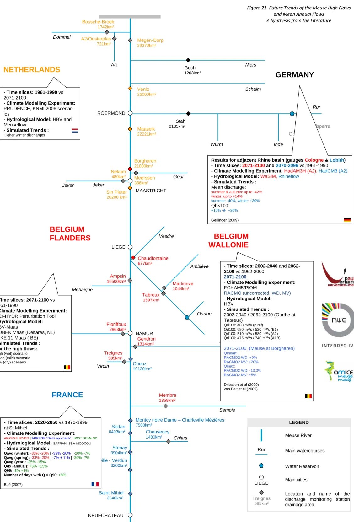
In addition to the existing databases list, a synthesis of literature about the climate change on the Meuse basin was performed. The purpose of this step is to know if the subject has already been sufficiently documented to allow the execution of AMICE works based on the findings of existing studies. These studies are presented in Figure 19 for the future change in precipitation and in Figure 20 for the future change in air temperature. Several GCMs and RCMs are used in the studies. They all give quite clear trends for the Medi‐ terranean region (very strong increase of temperature and decrease of precipitations) and the Scandinavian region (strong increase of temperature and increase of precipitation). But the Meuse basin lies between these two regions and, depending on the models used, the Meuse basin gets dryer or has increased precipitation.
The Amice partners decided to split climate model outputs into two future climates to study the two possible evolutions of the basin’s climate: a wet one and a dry one. This pragmatic approach was adopted due to: (1) a limited time to use what was available, (2) the uncertainty of some climate models saying it will be drier and others indicate a wetter future. However most models indicate a drier summer. And most models in the Rhine catchment say that win‐ ters will be wetter.
We can mention here that, in the framework of the EU PRUDENCE project, Blenkinsop and Fowler (2007) tested several regional climate models, in particular on the Meuse basin. The regional climate models yielded a wide range of abnormalities: from 0% change to 60% change on a same month. It is thus not surprising that the AMICE Partners are confronted with very distinct outputs from their national climate simulations. The same authors mention also that several models demonstrate the spatial variability of climate change. It is noted that the drought effect will be more pronounced in the southernmost and northernmost parts of the Meuse basin.
In the Netherlands, until 2006, the climate scenarios of Waterbeheer 21e eeuw or WB21 (Wa‐ ter Management 21st century, 2000) were used as a reference for future water management. Based on more recent insights from worldwide climatological research, these scenarios were replaced by the KNMI 2006 scenarios, presented by the Royal Netherlands Meteorological Institute (KNMI). These (four) scenarios now serve as the national standard in adaptation policies in the Netherlands (Hurk et al., 2006; Ministerie van Verkeer en Waterstaat (2009) Nationaal Waterplan).
The scenarios proposed by the AMICE Partners are plausible scenarios: they are not much different from the trends used in other climate impacts studies. However, it does not mean that the wet or dry climate scenario will indeed happen. The water managers and decision makers should be very aware that our results only represent two possible future climate trends, without any absolute certainty on which climate will occur.
LIEGE Main cities
LEGEND
Meuse River Rur Main watercourses
Treignes
585km²
Location and name of the discharge monitoring station drainage area Water Reservoir Meuse river Basin: A Synthesis from the Literature Chiers Semois Lesse Ourthe Wurm Vesdre Mehaigne Inde Rur Schalm Niers Dommel Amblève Sambre Geul Jeker NEUFCHATEAU NAMUR LIEGE MAASTRICHT ROERMOND
FRANCE
BELGIUM
FLANDERS
NETHERLANDS
BELGIUM
WALLONIE
GERMANY
Chauvency 1480km² Membre 1358km² Gendron 1314km² Floriffoux 2863km² Tabreux 1597km² Martinrive 1044km² Chaudfontaine 677km² Ampsin 16500km² Nekum 480km² Meerssen 386km² Borgharen 21000km² Stah 2135km² Maaseik 22221km² Venlo 26000km² Bossche-Broek 1742km² Megen-Dorp 29370km² Aa A2/Oosterplas 721km² Goch 1203km² Obermaubach Rurtalsperre Chooz 10120km² Treignes 585km² Belleville - Verdun 3200km² Stenay 3904km²Montcy notre Dame – Charleville Mézières
7500km² Saint-Mihiel 2540km² Viroin Jeker Sin Pieter 20200 km² Sedan 6493km² - Time slices: 2045-2065 vs 1961-1990 - Climate Modelling Experiment:
23 GCM/RCM simulations (SCRATCH08)
- SRES emission scenarios: A1B/A2/B1 - Simulated Trends :
Winter : 0 Î +100mm Summer : -100 Î -200mm Pagé et al (2008)
Results for North Rhine Westphalia - Time slices: 2071-2100 and 2021-2050
vs 1971-2000
- Climate Modelling Experiment: REMO, CLM, WETTREG, STAR
- SRES emission scenarios: A1B - Simulated Trends: 2021-2050 vs 1971-2000 Winter: -5%, 0%, 20%, 0% Summer: 0%, 0%, -10%, -20% 2071-2100 vs 1971-2000 Winter: 15%, 20%, 50%,- Summer: -15%, -10%, -15%, - http://www.mad.zmaw.de/projects-at-md/sg-adaptation/other-regional-model-data/zwek/ - Time slices: 2071-2100 vs 1961-1990 - Climate Modelling Experiment:
31 RCMs and 27 GCMs (Uccle)
- SRES emission scenarios:
A1B/A2/B1/B2
- Simulated Trends:
High (wet) scenario Mean (mild) scenario Low (dry) scenario
- Time slices: 2071-2100
- Climate Modelling Experiment:
5 GCMs CCI-HYDR ARPEGE HAD_P_H - SRES emission scenarios:
A2 / B2 A1B/A2/B1/B2 A2 - Simulated Trends: Winter: +6% Æ+23% +10% low: -6 Î +9% mean: +9Î+32% high: +21Î+66% Summer: 0% Æ -50% 0% Æ -3% low: -54Î-36% mean:-29Î-12% high: -14Î+12% Annual: -1,9% -15.3% d’Ieteren at al., 2004 Marbaix et al., 2004 Goderniaux et al., 2009 Willems et al., 2009 - Time slices: 2021-2050, 2071-2100 vs 1961-1990
- Climate Modelling Experiment:
10 RCMs and 3 GCMs (PRUDENCE)
- SRES emission scenarios
-KNMI 2006 scenarios GW G+ W+ - Simulated Trends: For 2050: G W G+ W+ Winter: +4 +7 +7 +14% Summer: +3 -10 +6 -19% For 2100: Winter: +7 +14 +14 +28% Summer: +6-19 +12 -38%