Journal of Fundamental and Applied Sciences is licensed under aCreative Commons Attribution-NonCommercial 4.0 International License. Libraries Resource Directory. We are listed under Research Associations category.
IDENTIFICATION OF HYDROGEOCHEMICAL PROCESSES IN A NORTH EASTERN ENDOREIC BASIN UNDER SEMI-ARID CONDITIONS (ALGERIA)
D. Dib1,2,3, A. Khiari1,3, K. Kadi2, M. Oualdjaoui2,N. Gherraf1,3
1
Université Larbi Ben Mhidi. Oum el Bouaghi, Algeria
2
Université Abbas Laghrour. Khenchela, Algeria
3
Laboratoire Ressources Naturelles et Aménagement des Milieux Sensibles, Université Larbi Ben Mhidi. Oum el Bouaghi, Algeria
Received: 19 Febraury 2017 / Accepted: 29 August 2017 / Published online: 01 September 2017
ABSTRACT
Statistical and geochemical methods were used to identify the factors influencing the behavior of groundwater in the Tarf watershed, characterized by a high water deficit. The chemical facies deduced from the piper diagram and the correlations between different major cations and anions evoked a dominance of the evaporite minerals with respect to the carbonates which are saturated and precipitated. Besides the projection of the results of a few points followed over a period of 4 years (2011-1015) on the Gibbs plot demonstrates the dominance of the processes of evaporation - precipitation with respect to the erosion which is very slowed during the last years due to the fact of lack of effective precipitation.
Keywords: Geochemistry; Endoretic basin; Tarf, Piper, Gibb’s plot.
Author Correspondence, e-mail: dib19819@yahoo.fr
doi: http://dx.doi.org/10.4314/jfas.v9i3.28
1. INTRODUCTION
The protection of groundwater is essential for the intrinsic value of this resource for various uses including its environmental value [1]. In the arid and semi-arid regions, about 30% of the
ISSN 1112-9867
land area, groundwater and surface water supplies suffer from low rainfall, in particular from their effluent-generating effect [2]. In Algeria, precisely in the area of high plains, surface water is scarce and the use of groundwater is the main alternative. Thus, the process of evaporation in semi-arid zones leads to the enrichment of groundwater causing an increase in salinity [3] which makes them unsuitable for human consumption.
This deterioration in the groundwater quality of the Tarf basin has been the subject of several local studies [4-5]. Studies on the hydrochemical behavior of water in arid and semi-arid zones have been adopted by several authors [6-7-8].
In the Tarf basin, the supply of drinking water comes mainly from the groundwater, which makes this resource vulnerable in quantity as well as in quality. This work contributes to a characterization of this resource which aims to identify the processes that participate in the increase of mineralization.
2. MATERIELS AND METHODS 2.1. Characterization of the watershed
According to the division of the hydrological units in Algeria, the basin of Tarf (07-07) with
an area of 2400 km2 belongs to the great watershed of the Constantine Highlands and to the
whole Constantine-Seybouse-Mellègue. Geomorphology is dominated by high plains strewn with depressions constituting chotts and sebkha. The low yielding cereal plains surrounding these depressions extend as far as the eye can see [9].
The average altitude is 971 m and reaches up to 2328 m at the level of the mountain of Chelia of the Mountain series of the Aurès to the south of the watershed. The northern part of the basin is characterized by the presence of some separate mountains, the most noteworthy being djebel Sidi Rghis (commune of Oum el Bouaghi), djebel Tarf, djebel El Oust and Kef Gouriret (commune of Ain Zitoune).
The sebkha occupies the central part of the basin, with an area of 33,000 hectares. It hosts the waters of various wadis and chaabet crossing the plains (endoreic basin). During the periods of flooding the sebkha turns into a real lake of water slightly brackish and feeds the neighboring chotts.
Fig.1. Geographical situation of the Tarf basin (07-07)
The climate is semi arid, cold in winter dry, and hot in summer, deeply affects the water reserves. During the monitoring period (2011-2015) the total annual precipitation did not exceed 500 mm. These years of aridity have caused the drying up of several wells and wadis. 2.2.Geology and hydrogeology
The stratigraphic series ranges from the Triassic to the Quaternary [10]. The cretaceous materials of various ages occupy a fairly important space of all the mountains which surround the basin (fig.2). It is dominated by more or less fissured limestones forming captive nappes where several springs appear, including that of Ain Serraba at djebel Tarf. The limestones of dj.El Oust are exploited for the production of sand and gravel. Quaternary filling is the most dominant. The arable lands and the very permeable ancient silts coincide with the beds of wadis and faids where the alluvial sheets are formed.
During periods of low water, the supply of these aquifers is made by the infiltration of the rainwater and the waste water discharged in their raw state; This is the case of faid Souar and Tegouft for the commune of Oum el Bouaghi, Faid Abbou Lakhdar for the city of Ain Beida and Oued Nini for the city of F'kirina. Around the Sebkha Tarf and Guellif the aquifers show a very high salinity. On the surface these layers are surmounted by dune formations.
Fig.2. Geology of the watershed modified from 1 / 50000 maps of Oum el Bouaghi, Ain Beida, Garaet Tarf, Fkirina, Dalaa and Khenchela.
2.3. Analytical and statistical tools
The 47 sampled water points were subjected to a physico-chemical characterization. This included the electrochemical measurements (pH, CE, ORP, dissolved oxygen,…) and the
determination of the contents of major anions and cations (Na+ , K+, Ca2+, Mg2+, Cl-, HCO3-,
SO42- and NO3-) according to the methods standardized by J Rodier [11].
The determination of sulphates for sebkha waters was carried out using a gravimetric method which consists in precipitating and weighing the pellet formed after drying, because of the high contents. Quantities of added tween solution can not maintain barium sulfate in suspension for spectrophotometric quantification. The nomination of the wells and boreholes was made according to their communal affiliation or relative to their owners. The PCA was performed using the Xl-STAT software, 2007. This statistical method has been widely applied
to investigate environmental phenomena and hydrogeochemical processes throughout the world [12] and choose appropriate characteristic relationships.
The Piper plot as well as the calculation of the saturation indices were carried out using the diagrams software (LHA Avignon), this method has been widely used by several authors to study the behavior of minerals.
3. RESULTS AND DISCUSSION
3.1. Characterization and chemical facies
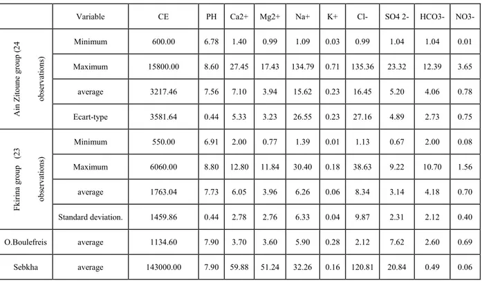
The hydrochemical characterization of groundwater is the first step in any quality study. The results of the physicochemical analysis of the groundwater are presented in the table.1. The conductivity values range between 550 and 6060 μS / cm for the groundwater of the F'Kirina group and 600 up to 15800 μS / Cm for the waters of the Ain Zitoune group which appear more mineralized because these points are influenced by salts of the sebkha. Before penetrating into the soil, rainwater can dissolve aerosols such as chloride of sodium as was found in the sebkha of Ben Ziane [13].
It also emerges from the averages of major element contents that the dominant cations are
Ca2+ and Na+ at the level of the two groups. For the group of Ain Zitoune the dominant anions
are Cl- and SO42- (feeding by the waters of the Oued Boulfreis rich in sulphates) and Cl- +
HCO3- for the Deeper waters of the F'Kirina group). FK4, FK8 and FK14 of the F'Kirina
group are far from the depression, but their geographic position in relation to the prevailing wind direction in the watershed (NW) allows them to undergo the action of aerosols.
It also emerges from the diagram that Wadi Boulefreis, the main watercourse which supplies the sebkha, brings large quantities of sodium and sulphates to the basin, its content in the latter exceeds the average of the waters of the two groups. This is due to the thrusting of salts
of the South Aurasian salt formations [14]. The source of ain touam (Sat) located on the
southern piedmont of djebel Tarf near the sebkha does not seem affected by the action of the salts (deep water).
The projection of the water points of the f'kirina group on the Piper diagram showed the dominance of the chloride and sulphate facies calcium and magnesium as well as a clear
anionic differentiation (dominance of chlorides and bicarbonates). On the other hand, the chemical composition of the waters of the Ain Zitoune group is less heterogeneous; it is the water points located on the edge of the Tarf sebkha that capture the superficial water table. In this case the ionic dominance tends towards chlorides and sodium.
The mineralization of the waters of the chloride and sulphate facies (designated by a violet color on the two diagrams) is greater compared to the other facies. This type of facies thus includes the superficial waters of the sebkha.
Table .1. Sample descriptive statistics
Variable CE PH Ca2+ Mg2+ Na+ K+ Cl- SO4 2- HCO3- NO3-
Ain Zi tou n e gro up ( 2 4 o b serv atio n s) Minimum 600.00 6.78 1.40 0.99 1.09 0.03 0.99 1.04 1.04 0.01 Maximum 15800.00 8.60 27.45 17.43 134.79 0.71 135.36 23.32 12.39 3.65 average 3217.46 7.56 7.10 3.94 15.62 0.23 16.45 5.20 4.06 0.78 Ecart-type 3581.64 0.44 5.33 3.23 26.55 0.23 27.16 4.89 2.73 0.75 Fki ri na g ro u p (2 3 o b serv ations) Minimum 550.00 6.91 2.00 0.77 1.39 0.01 1.13 0.67 2.00 0.08 Maximum 6060.00 8.80 12.80 11.84 30.40 0.18 38.63 9.22 10.70 1.56 average 1763.04 7.73 6.05 3.96 6.26 0.06 8.34 3.14 4.18 0.70 Standard deviation. 1459.86 0.44 2.78 2.76 6.33 0.04 9.87 2.31 2.12 0.40 O.Boulefreis average 1134.60 7.90 3.70 3.60 5.90 0.28 2.12 7.62 2.60 0.69 Sebkha average 143000.00 7.90 59.88 51.24 32.26 0.16 120.81 20.84 0.49 0.06
3.2. Correlations and origin of elements 3.2.1. Principal Component Analysis
Principal component analysis makes it possible to assign the correlations between the different elements. The present analysis consists of 10 variables. The choice of the factorial plans to be taken was based on the method of calculating the n: p ratio (n: number of observations and p: number of variables). It determines the results stability. Some references assert that ACP is truly possible only if this ratio is greater than 3 [15-16]. For the present study we have n: p = 4.7.
The first axis expresses 46.25% of the variance of the evaporite pole [17] with a set of
variables: Na+, Cl-, Ca2+, Mg2+ and SO42-. The individuals presenting this axis are the wells
and boreholes, particularly those of the F'Kirina group, which are subjected to the action of the aerosols of the sebkha. The second axis shows 18.41% of the variance is strongly correlated with bicarbonates and nitrates that are negatively correlated. Individuals following this axis have significant alkalinity. Water alkalization may be caused by an increase in photosynthetic activity [18].
The organisms attract the H3O+ and carbone ions, in the presence of light, to produce organic
matter [19]. These are water points which present uncovered wells: FK11, FK14, AZ6, AZ12,
AZ15, AZ16, AZ17, AZ18 and AB3. Besides the consumption of H3O + and C ions, aquatic
algae consume nitrates in some polluted structures. The points: FK10, AZ1, oeb3, oeb5 and oeb 14 are strongly correlated with the axis of the nitrates. This has been revealed since the
projection on the plane I-IV. They have high levels of NO3- (64 to 226 mg / l) exceeding
Algerian and European standards for drinking water. The matrix of correlation between chemical variables (Table 3) reveals several significant correlations.
A strongly significant correlation (r> 0.8) was observed between the elements: Na+, Cl- and
SO42- indicating their common evaporite origin: Halite (NaCl) and mirabilite (Na2SO4).
Cl + SO4 Na(K)Cl(SO4) Ca(Mg)Cl(SO4) Ca(Mg)HCO3 Sebkh O.Boulfrei O.Boulfrei
Important anion-cation and anion-anion relationships were observed between the different elements. The sulphates have relations with the calcium and chloride elements. Their relation with chlorides indicates a common origin, but the relation with calcium evokes the dissolution of gypsum. When the waters are strongly mineralized, the chloride-sulphate competition becomes to the advantage of the chlorides which gradually impose their predominance [20], hence the dominance of Halite. The minerals mentioned above are formed under extreme conditions of temperature, which is consistent with the climatic context of the basin.
Table.3. Correlation matrix (Pearson)
Variables CE pH Ca2+ Mg2+ Na+ K+ Cl- SO42- HCO3- NO3 -CE 1 pH -0.0080 1 Ca2+ 0.7123 0.0640 1 Mg2+ 0.4386 0.0955 0.4056 1 Na+ 0.8390 0.0623 0.6604 0.5579 1 K+ 0.4861 -0.2323 0.2410 -0.0500 0.3367 1 Cl- 0.8999 0.0756 0.7748 0.5739 0.9186 0.2978 1 SO42- 0.6430 0.1367 0.5890 0.6670 0.8696 0.2395 0.7846 1 HCO3- -0.1242 0.0889 0.0521 0.2616 0.1497 -0.3692 -0.0462 0.2058 1 NO3- 0.0316 -0.1614 0.0186 -0.0317 -0.0308 0.2236 -0.0123 -0.1275 -0.2582 1
Fig.4. Projection of variables and individuals on plot I-II
Highly significantcorrelation SignificantCorrelation
3.2.2. Origin of the elements
The studies of the distribution of chemical facies using characteristic ratios have been adopted by several authors [17-21] by choosing the relations between dominant cations and anions. The importance of the evaporite facies led us to search among the minerals generating this facies, which are characteristic of the studied waters [22].
a- The pair Na+-Cl- and Na+-SO4
2-The spatial evolution of the sodium contents as a function of chloride ions has been graphically plotted (fig.5). Below the line of dissolution are the water points which show a depletion of sodium which indicates its origin (dissolution of the halite). On the contrary, the points above the slope present a sodium enrichment at the origin of a basic exchange
Examination of the Na-SO4 relationship shows more dispersed points with respect to the
regression line except for a few extreme cases, indicating the common origin of sulphates and sodium. This time the majority of the points are below the line, indicating the sulfated origin of the sodium ions. This relationship confirms the existence of sodium sulphate facies.
b- The basic exchange
The exchange capacity varies considerably depending on the nature of the clays. Studies of ionic exchange in geological formations have revealed that, in general, during the exchange process one of the ions is retained very strongly against any displacement by the other ions. It is a preferential adsorption known by ion exchange selectivity [23]. The projection of the
water points on the diagram (Ca / (SO4 + HCO3) - Na / Cl) on Fig.5 shows that more than
60% of the water points have a deficit in Na+ and Ca2+ characteristic of the natural state
waters. The 14% of the observations present a deficit of Cl- and Ca2+ (base exchange) and the
remaining points present an excess in calcium characteristic of the waters which undergo the action of the evaporite formations.
c- The Origin of Calcium
Examination of the Ca - (HCO3 + SO4) relationship clearly showed points more or less
dispersed with respect to the slope, indicating the common origin of sulphates and calcium. The excess calcium presented by the points above the line indicates a gypsiferous origin of the
In semi-arid zones the lack of effective precipitation and the high pH of the water do not favor the dissolution of the carbonates while the gypsum is easily soluble.
d- Origin of salinity
The relationship HCO3- / (Cl- + SO42-) - electrical conductivity
We notice here a logarithmic decrease of the ratio as a function of the conductivity. A dominant pole has been observed (fig. 6), the evaporite pole and affirms a dominance of the
Cl- and SO42- ions. This pole appears clearly even for the weak conductivities and brings
together the majority of the points.
This report allows us to say that the conductivity in our study area is related to the evaporites resulting from the leaching and infiltration of salts of the Tarf sebkha.
Fig.5. Characteristic relationships and origin of elements SO4 Na/Cl Na/SO4 Ca/(S O4+ HCO3 ) Na/Cl HCO3+SO4 Ca Etat natur el Echange de base Exè s en calcium
The relationship Cl- / SO42- - electrical conductivity
This report enables us to determine the way in which the dissolution of evaporite ions (Na+
halite marker and SO42- gypsum marker) evolves as a function of conductivity. The
rearrangement of the points on the graph (fig. 6) shows that most points have a ratio greater than 1, indicating a dominance of saliferous ions compared to those of gypsum. A linear relation of this ratio as a function of conductivity could be represented for the majority of the points. A single water point showed a distance from the others because of its approach to the depression indicating that the increase in conductivity is related only to the quantity of ions dissolved in the water whose origin is the depression.
Fig.6. Origin of salinity 3.3. Mineral saturation indices
The analysis of fig.7 Which represents the variation of the different saturation indices of the carbonate minerals according to the studied samples, show that the majority of the points are supersaturated with respect to these minerals, indicating an intense precipitation of the latter. This concerns mainly the deep-water drilling. The Well waters remain far from saturation points. For evaporite minerals (Fig. 8), we note a sub-saturation with a descending order starting from the Halite to the Gypsum which is near the saturation points.
Cl/SO4 Conductivité HCO3/( Cl+ SO4 ) Conductivité Cl/SO4 Conductivité
Fig.7. spatial evolution of saturation indices of carbonate minerals
Fig.8. spatial evolution of saturation indices of evaporitic minerals
3.4. Gibb’s plot
The factors controlling the chemistry of groundwater can be related to the physical conditions of the aquifer, the nature of the substratum and climatic conditions. A follow-up during a 4 year period was carried out on the six points closest to the sebkha (southern slope of Djebel Tarf). The results of the projection on the Gibb’s plot show a grouping of points under a single category governed by the Evaporation-precipitation phenomena characteristic of the semi-arid climate.
Fig.9. Gibb’s plot
4. CONCLUSION
The Tarf endoreique basin contains several aquifers, the most vulnerable of which is the superficial aquifer which is subjected to the action of aerosols which increase the mineralization of waters, especially near the sebkha. Two dominant facies were observed, the chloride and sulphate calcium and magnesium characteristic of the shallow waters and the bicarbonate calcium of the deep domain.
The results of the interpretation of the main component analysis show that the electrical conductivity is related to the saliferous ions with a correlation coefficient greater than 0.8
1 < TDS < 100 Rainfall dominance
100 < TDS < 1000 Rock dominance
1000 < TDS < 10000 Evaporation- precipitation dominance
followed by the characteristic ions of the evaporites (Ca2+ and SO42-). No significant
relationship was observed between Ca2+ and bicarbonates based on the study of characteristic
ratios. The carbonate pole characterizes only 14% of the observations compared to the evaporite pole (86%).
It should be noted that this was proved after calculating the saturation indices of the minerals which showed the tendency to precipitate carbonates which does not allow them to remain in solution resulting in the depletion of water in bicarbonates. The spatio-temporal evolution of the water chemistry of a few points projected on the Gibbs plot showed significant variations in the levels of dissolved salts according to the years as well as the dominance of the evaporation-precipitation phenomena.
5. ACKNOWLEDGEMENTS
Our thanks go especially to Mr. Antonio Pulido-Bosch, professor in hydrogeology at the University of Almeria-Spain, Mr. Hemaizia.I, Guitoune.G and Dib.R of the patience who showed during the periods of outings.
6. REFERENCES
[1] Quevauviller P. Protection des eaux souterraines. In Lavoisier (Eds.), Legislation européenne et avancées scientifiques. Paris :Tech and Doc, 2010, pp.26-28.
[2] Margat J, van der Gun J. Groundwater around the World. In Taylor and Francis(Eds.), A Geographic Synopsis. London, New York: CRC Press, 2008, pp.342.
[3] Taheri Tizro A, Voudouris K.S. Ground water quality in the semi-arid region of the chahardouly basin. West Iran. Hydrol Processes., 2007, 22(16) :3066-3078.
[4] Houha B. Etude du fonctionnement hydrogéologique et salin d'un bassin semi-aride. Rémila – Khenchela. Thèse Doc., Université Badji Mokhtar Annaba. ,2007.
[5] Dali N. Ressources et gestion intégrée des eaux du bassin de garaet el Tarf. Khenchela. Mem Mag., Université annaba.,2009,132 pages.
[6] Ncibi K, Gaaloul N, Gasmi A. Contribution of the multivariate analysis and the GIS for Hydrochemical characterization of phreatic aquifer to the plain of Sidi Bouzid ,Central
Tunisia. IJAS journal Studies.,2016,15: 667-684.
[7] Sheikhy Narany T, Firuz Ramli M, Zaharin Aris A, Azmin Sulaiman W N, Juahir H, Fakharian K. Int. Corporation Scientific World Journal. 2014, doi: 10.1155/2014/419058 [8] Talabi A O. American journal of water resources. 2013, 1(3),25-33, doi: 10.12691/ajwr-1-3-2.
[9] ANRH. Rapport sur l’état et l’avenir de l’environnement.2002.
[10] Wilidi W. La chaîne tello-rifaine (Algérie. Maroc. Tunisie). Rev. Geol. Dynam. Geogr. Phys. In Masson(Eds.),1983,pp. 201-297.
[11] Rodier J, Legub B, Merlet N. L'analyse de l'eau .In Dunod (Eds.), 2009, 1368 pages. [12] Anazawa K, Ohmori H, Tomiyasu T, Sakamoto H. Hydrochemistry at a volcanic summit area Norikura central Japan. In Geochimica and Cosmochimica Acta,2003, 67(18).
[13] Benziane A. Problèmes géologiques et hydrogéologiques de la Sebkha de Ben Ziane (Nord-Ouest algérien). Thèse Doc 3e cycle. Univ Claude Bernard-Lyon I. 1983, 280 pages. [14] Benazzouz M T. Recherches géomorphologiques dans les hautes plaines de l’Est Algérien : la sebkhet Tarf (Algerie).1984, 294 pages.
[15] Grossman G, Nickerson D, Freeman M. Principal Component Analyses of Assemblage Structure, Utility of Tests based on Eigenvalues. In Ecology.72(1),1991, pp. 341-347.
[16] Saporta G. Probabilités analyses des données et Statistiques.In Dunod (Eds), 2006. [17] Debieche T H. Evolution de la qualité des eaux (salinité, azote et métaux lourds) sous l’effet de la pollution saline, agricole et industrielle. Thèse Doc. Université de Franche-Compte,2002, pp. 197.
[18] Serghini A, Fekhaoui M, El Abidi A, El Blidi S, Ben Akkame R. Caractérisation hydrochimique d’un site Ramsar, le complexe zones humides de mohammedia (Maroc). Bulletin de l’institut scientifique Rabat. Section sciences de la vie, 2010, 32 (2).pp. 133-145. [19] Westlake D F, Ladle M. River and stream ecosystems of Great Britain. In : Cushing C E, Cummins K W, Minshall G W (Eds.), 1995,pp.343- 388.
[20] Bakari M S, Christian A, Raoul C, Jean P. Faciés Hydrochimique et minéralisation des eaux souterraines côtiéres de la nappe du Trarza (Mauritanie). Journal Sochini N°6, 1996. [21] Gouaidia L. Influence de la lithologie et des conditions climatiques sur la variation des
paramètres physico-chimiques des eaux souterraines d'une nappe en zone semi aride, cas de la nappe de Meskiana, Nord-Est Algérien. Thèse Doc. Université d'Annaba,2008, pp 129.
[22] Brinis N, Boudoukha A, Djabri L, Mania J. La salinité des eaux souterraines de la zone Est de la plaine d’El Outaya, Région de Biskra, Algérie. Bulletin Service Géologie National. 2009, 20(1), pp. 49-61.
[23] Ghebouli S. Utilisation des ACP et des rapports caractéristiques dans l’explication du
chimisme des eaux souterraines cas de la plaine de bir haddada (sud de Sétif). Sciences and Technologie D. N°32,2010, pp. 51-59.
How to cite this article:
Dib D, Khiari A, Kadi K, Oualdjaoui M and Gherraf N. Identification of hydrogeochemical
processes in a north eastern endoreic basin under semi-arid conditions (Algeria). J. Fundam. Appl. Sci. 2017, 9(3), 1685-1700.