Terrestrial groundwater and nutrient discharge along the 240-km-long
Aquitanian coast
Pierre Anschutz
⁎
, Céline Charbonnier, Jonathan Deborde, Loris Deirmendjian, Dominique Poirier,
Aurélia Mouret
1, Damien Buquet, Pascal Lecroart
Université de Bordeaux, CNRS, UMR 5805 Environnements Paléoenvironnements Océaniques et Continentaux (EPOC), 33615 Pessac, France
a b s t r a c t
a r t i c l e i n f o
Article history: Received 6 October 2015
Received in revised form 10 February 2016 Accepted 6 April 2016
Available online 9 April 2016
We collected samples from sea water, runnel water, beach pore waters, water from the unconfined surficial aqui-fer discharging at the beach face, groundwater, and rainwater from the Aquitanian coast in order to determine theflux of dissolved inorganic nitrogen (DIN), phosphorus and silica from terrestrial submarine groundwater dis-charge (SGD). Theflux of fresh groundwater was obtained from a water balance calculation based on precipita-tion and evapotranspiraprecipita-tion and assessment of the coastal watershed from hydrograph separaprecipita-tion. Waters with intermediate salinities between sea water and freshwaters are found all along the 240-km-long coast, indicating that SGD is ubiquitous. The estimated fresh waterflux is 2.25 m3d−1m−1longshore. Terrestrial SGD provides a
DINflux of 9·106mol each year to the adjacent coastal zone. Thisflux is about four times lower than the release of
DIN due to tidally driven saline SGD. The freshwater DINflux is low because the upland land use consists almost exclusively of pine forest. Dissolved organic nitrogen represents more than 60% of the total dissolved nitrogen flux. Dissolved iron, phosphorus and silica have much higher concentrations in the anoxic forest aquifer than in the fresh-water end-member of the subterranean estuary sampled in the upper beach aquifer. This suggests that the salinity gradient of the estuary does not correspond to a redox gradient. The redox front between anoxic groundwater and fresh oxic waters occurs below the soil-depleted foredune/yellow dune. Anoxic P- and Si-rich waters seep directly on the beach face only in the north Gironde, where the foredunes are eroded. This study re-veals the role of the sandy foredune aquifer in biogeochemicalfluxes from SGD, which is to dilute and oxidize wa-ters from the unconfined surficial upland aquifer.
© 2016 Elsevier B.V. All rights reserved.
Keywords:
Submarine groundwater discharge Nutrient
Coastal dune Subterranean estuary
1. Introduction
Submarine Groundwater Discharge (SGD) plays a significant role in freshwater and biogeochemicalfluxes of some coastal zones (Moore, 2010) and the global ocean (Kwon et al., 2014). Direct SGD might be re-sponsible for up to 10% of the total terrestrial water input to estuaries and to the ocean (Garrels and MacKenzie, 1971). It may represent 2400 km3y−1(Zektser and Loaiciga, 1993) compared to total runoff,
which is estimated at 37,400 km3y−1(Berner and Berner, 1987).
The world's coastlines are dominated by sandy shores (McLachlan and Brown, 2006). The intertidal zone of permeable sandy sediments represents an environment where nutrient dynamics is governed by diagenitic recycling of biogenic compounds (e.g.Billerbeck et al., 2006), recirculation of pore waters (Deborde et al., 2008; Anschutz et al., 2009), or seepage of terrestrial groundwaters (e.g.Ullman et al.,
2003; Charette and Sholkovitz, 2002). Seepage of terrestrial
groundwater through coastal permeable sediments occurs where aqui-fers have a positive head relative to sea level; almost all coastal zones are subject to suchflow (Burnett et al., 2006). Therefore, freshwater dis-charge through coastal sandy sediments has been recognized as a wide-spread phenomenon. Fluid circulation in tidal permeable sediment has received increasing attention due to its potential importance in the transport of chemical constituents to the sea. Freshwater inputs have ef-fects on the carbon and nutrient cycles (Kroeger and Charette, 2008; Spiteri et al., 2008; Bowen et al., 2007), but estimatedfluxes of terres-trial groundwater are highly variable and quantification remains prob-lematic. That is why very few data exist on the direct contribution of groundwater to nutrient input to coastal zones. On a local scale, groundwater-borne nutrient loads may be important in maintaining primary production (Zimmermann et al., 1985; Lee et al., 2010). But when coastal pore water is mixed with terrestrial groundwater, it be-comes difficult to determine the proportion of nutrient input caused by in situ mineralization of organic matter (e.g.Charbonnier et al., 2013a) and that originating from freshwater seepage.
Different approaches have been used to improve estimates of groundwaterflow and nutrient load to coastal ocean (Burnett et al., 2006). Groundwater temperature can be used to estimate groundwater
⁎ Corresponding author.
E-mail address:[email protected](P. Anschutz). 1
Present address: UMR-CNRS 6112 Université d'Angers LPG-BIAF 49045 Angers, France.
http://dx.doi.org/10.1016/j.marchem.2016.04.002
0304-4203/© 2016 Elsevier B.V. All rights reserved.
Contents lists available atScienceDirect
Marine Chemistry
discharge rates. A temperature difference in the groundwater –surface-water system is a qualitative signal of ground–surface-water seepage that can be detected using remote sensing infrared signal (Fischer et al., 1964; Lévêque et al., 1972;Roxburgh, 1985; Banks et al., 1996). The use of re-mote sensing technologies to quantify groundwater seepage requires intensivefield calibration, which has never been performed. Seepage meters are a direct technique that can be used in a relatively calm envi-ronment (Taniguchi and Fukuo, 1993). Recent developments of radium and radon isotopic techniques have permitted evaluations of ground-waterflows at local, regional, and global scales (Moore, 2010; Kwon et al., 2014). These techniques may discriminate terrestrial water seep-agefluxes from recirculating sea water in permeable marine sediments. Radium and radon are commonly used as tracers of saline and total SGD, respectively. The difference between them is the fresh part (Knee and Paytan, 2011). But radon is subject to exchange with the atmosphere, which may be difficult to model under some circumstances (e.g., waves breaking along a shoreline). Another approach is the water balance calculation. This approach simply links the terrestrial aquifer with the beach through the discharge of groundwater, which is set by precipitation, evapotranspiration, runoff, and groundwater pumping over an extended period in the catchment area that drains the coastal zone directly. Estimates of nutrient load obtained from this approach may be based on measured nutrient concentrations from up-land monitoring wells. However, groundwater nutrient concentrations are generally transient because of biologically and chemically mediated reactions (e.g.,Ullman et al., 2003; Slomp and Van Cappellen, 2004; Kroeger and Charette, 2008; Santos et al., 2008). To account for such non-conservative behaviour in an aquifer, groundwater load estimates can be based on nutrient concentrations measured at the seepage zone (Charette et al., 2001; Michael et al., 2003; Loveless and Oldham, 2010).
Discharging groundwaterflux and its nutrient contribution are much easier to estimate in regions wherefluids may seep into a body of water having limited circulation, such as a semi-enclosed basin. Iden-tification of terrestrial groundwater nutrient flux on an open ocean re-flective beach with tidal currents and breaking waves remains a challenge. The 240-km-long Aquitanian coast is a sandy coast where nu-trient recycling due to sea water circulation and tidal pumping has been recognized from the study of saline (SN 34) interstitial and seeping wa-ters (Anschutz et al., 2009; Charbonnier et al., 2013a). Organic matter supplied by the sea water entering the pore spaces duringfloods is trapped long enough to be mineralized. This efficient recycling process supplies 600 tonnes of N-nitrate to the adjacent coastal zone annually. These studies also showed that some brackish waters could be sampled on the beach at low tide, suggesting that terrestrial water seepage oc-curred. To study the impacts of terrestrial groundwater on a large-scale high-energy coastal environment, we have made an estimate of the quantity of nutrients that are discharged to the coastal zone of the Aquitanian beach using a water balance calculation and spatial monitor-ing of groundwater in upland wells and seepmonitor-ing on the beach at low tide.
2. Material and methods 2.1. Study site
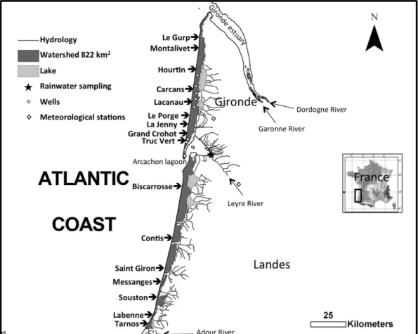
The French Aquitanian coast forms a vast unique natural environ-ment in Western Europe. This relatively protected milieu is a 240-km-long straight coast bordered by Aeolian dunes several tens of metres high and exposed to high-energy conditions in a meso-macrotidal set-ting. This coast is located between the Gironde and Adour estuaries (Fig. 1) and is interrupted by the Arcachon lagoon tidal inlet, which is approximately 5 km wide. The tide is of meso-macro type, with an aver-age tidal range of 3.2 m, extending up to 5 m during spring tides. The Aquitanian coast commonly displays double bar beaches with very dy-namic rhythmic features, such as the presence of ridge and runnel
systems developed more or less in relation with meteorological condi-tions (Michel and Howa, 1999; Castelle et al., 2007). The coast is ex-posed to high energy North Atlantic swells travelling mainly from the W–NW sector (Butel et al., 2002). Beaches are mainly intermediate double-barred following the classification ofShort (1991)andShort and Aagaard (1993).
A morphological analysis has subdivided the Aquitanian coast from north to south into two main groups with homogeneous dynamic be-haviour: the coast north of the Arcachon bay with gentle slope beaches, which are subjected to erosion in the northernmost part; and the more stable coast south of the Arcachon bay, with beaches increasingly in-clined toward the south. The beaches between the Verdon and Montalivet are in erosion. There, the beaches areflat and limited by cliffs made of Pleistocene cemented sands and palaeosoils. Terrestrial groundwater seeps directly out of the cliffs at the sand palaeosoils limit. The beach catchment, that is, the land area that is not drained by a river or lakes and that is directly connected to the beach, has been delimited using the Geographic Information System (GIS) ArcGIS. It rep-resents a 0 to 10 km wide strip of land along the coastlines, which covers 822 km2. The coastal aquifer, composed of sand dunes, marine sands,
and gravels of Plio-Quaternary period, is very permeable (Legigan, 1979). Foredune and cultivated pine forests located behind the foredune on Holocene dunes represent more than 90% of the total sur-face of the catchment area. Housing is confined to a few spots of the coastal zone.
The mean precipitation in the middle part of the studied beach at Cap Ferret was 810 mm y−1between 1967 and 2014. In recent years, the values were 542, 744, 936, and 899 mm in 2011, 2012, 2013, and 2014 respectively, showing the large heterogeneity. The amount of water supplied by rainfall was compared to the streamflow in the neighbouring watershed of the Leyre river (Canton et al., 2012) so that an evaporation rate could be defined. The evaporation rate was be-tween 40 and 80%, which is typical of a forested catchment (Bosch and Hewlett, 1982; Vertessy et al., 2003). The direct measurement of evapo-transpiration in the dune forest located in the studied area gave a value of 51% (Pitaud, 1967), but this value was obtained from the measure-ments of transpiration of young pines during one year. It did not take into account the understory cover. A recent modelling approach that considered all the hydrological parameters and land covers indicated that evapotranspirationfluxes in pine forest of the Aquitanian coastal region were in the range of 234 to 570 mm y−1(Govind et al., 2014), which represented 30 to 70% of the mean annual precipitation. Low values were obtained for young stands whereas high values were ob-tained for mature pine forest. The dune forest consists mostly of mature forest, suggesting that evapotranspiration represented close to 70% of precipitation. The excess rainfall would go to either surface runoff or groundwater recharge. In the case of the Aquitanian coastal watershed, surface runoff does not exist and we consider that the excess water feeds the aquifer.
2.2. Sampling
Several kinds of water samples were collected, including sea water, runnel water, beach pore waters, water from the unconfined surficial aquifer discharging at the beach face, groundwater, and rainwater (Fig. 2). Runnel waters are those sampled in large pools isolated at low tide on the lower beach. Water samples of the intertidal zone were collected at low tide in winter and spring 2007, 2008, and 2009 at several places accessible by car along the Aquitanian coast (Fig. 1) and during several periods between 2011 and 2013 on Truc Vert Beach. Samples were collected during periods of spring tide. Truc Vert beach is located a few kilometres north of the Cap Ferret sand spit (Fig. 1). It is representative of the Aquitanian coast and protected from human disturbance by difficult access. The boundary between the unsaturated and saturated zones defines the water table. The inter-section of the water table and the beach face defines the seepage zone.
Pore waters were sampled in the saturated zone of the beach, where sediment pores werefilled by interstitial water. To collect interstitial and seeping waters on the beach, we bored several holes at low tide along cross-shore transects, until the borehole reached the saturated zone in the intertidal sandy beach. Pore waters were reached at the sur-face on the lower beach and down to 2 m depth on the upper beach. The first water that filled the bottom of the hole was removed with a poly-propylene beaker. Due to the high permeability of sand, the hole refilled immediately and the measurements of temperature and salinity and the sampling were performed on this water. Waters were immediately sub-sampled using a 50-mL syringe andfiltered through a 0.45 μm cellulose acetate syringe-membrane. Sea water and runnel water were sampled directly with a 50-mL syringe.
Three 7-m-long piezometers were put on the upper Truc Vert beach in February 2013, between the high spring tide level and the dune.
Installation of piezometers in the tidal beach section was ruled out be-cause of high-energy conditions. Oxygen concentration and tempera-ture were recorded with Aanderaa 3835 optodes equipped with NKE data loggers located at the bottom of each piezometer. These probes achieved a precision of ±5% for oxygen without consumption (optical measurement) or significant drift. The oxygen probes were tested in the laboratory before and after eachfield deployment. Samples were collected in February–March 2013 and in September–October 2013 every day during one lunar cycle. Three Tygon tubes with an inner di-ameter of 5 mm werefirmly fixed in each well at different depths in order to avoid disturbance and to obtain a vertical distribution of pa-rameters. Samples were brought to the surface through a 60-mL sy-ringe. At each sampling depth, several void volumes were pumped before sampling. We did not purge the whole well volume for the upper beach piezometers because the permeability of the beach sand
Fig. 1. Sampling site location. Arrows indicate beaches where pore waters were sampled at low tide. The beach watershed was determined from hydrograph separation.
Fig. 2. Schematic W–E cross-section of the beach-dune system and the different waters sampled: 1—sea water; 2—runnel waters; 3—beach pore waters; 4—upper beach piezometers; 5—forest wells; 6—rainwater.
was very high and to avoid mixing. Piezometers were mostlyfilled with air at low tide, and also at high tide in the case of the upper piezometer, because the water table was deep. Thus, in most cases, we sampled wa-ters only in the deepest Tygon tubing. When we were able to sample two or three tubes per piezometer, the values were replicated, indicat-ing that waters were homogeneous in the sampled part of the aquifer.
We also sampled waters from upland wells located behind the sand dune system in the pine forest drained directly by the beach (Fig. 2). These wells were about 10 m deep and were always drilled within the connected free aquifer. Waters from wells were sampled using a centrif-ugal pump. Waters pumped were left to overflow in a beaker while con-tinuously measuring the conductivity, temperature, and dissolved oxygen with WTW probes. When these parameters were stabilized, samples for chemical analyses were collected using a 50 mL syringe. Ox-ygen monitoring showed that these ground waters were always anoxic. In summary, this heterogeneous sample collection allowed us to obtain several discrete samples from different places on the Aquitanian coast and a complete profile of groundwater from the forest watershed to the sandy beach at Truc Vert.
We collected 58 and 60 samples of rainwater after each precipitation event during 2008 and 2011, respectively. 2008 was the most humid year of the last 20 y, whereas 2011 was the driest, with respective pre-cipitations at Cap Ferret of 970 and 542 mm. The rainwater collector was located in the middle part of the studied area in the southern part of the Gironde coast (Fig. 1). The collector was an opaque polypropylene bottlefitted with a funnel. Rainwaters were collected within a few hours after rain. Three meteorological stations covering the area (Fig. 1) provided data regarding the daily amount of rainfall. We used the average of the three stations to calculate the atmosphericflux of N and P.
2.3. Analyses
The temperature, dissolved oxygen, and salinity of water samples were immediately recorded in the waters using WTW probes or
Aanderaa optodes. The probes were calibrated before and after each field campaign using an IAPSO sea water and deionized water for the sa-linity. Salinity probes were compensated automatically for in situ tem-perature. Oxygen probes were calibrated before and after eachfield campaign using an oxygen-free solution and an aerated solution (100% saturation) for the oxygen saturation. Waters werefiltered through a 0.45-μm cellulose acetate syringe-membrane. Subsamples for dissolved inorganic phosphorus (DIP) were acidified with HNO3to
prevent scavenging by precipitation of iron oxide; two subsamples were kept frozen until later analyses of other dissolved nutrients. Dis-solved nitrate and nitrite were analysed byflow injection analysis using standard methods (Anderson, 1979). The precision obtained was ±10% for NOx (=NO3−+ NO2−). Dissolved silica, DIP, and ammonia
were analysed by colorimetric procedures (Mullin and Riley, 1955; Murphy and Riley, 1962; Strickland and Parsons, 1972). The frozen sub-sample was defrosted on the day of the NOx and ammonia analyses. The subsample was allowed to stand at room temperature for at least 24 h for depolymerization of silica before carrying out dissolved silica analy-sis. The obtained precision of these procedures was ±5%. The concen-tration of dissolved Fe was analysed on acidified subsamples by spectrophotometry (Stookey, 1970). Total dissolved nitrogen (TDN) concentrations were measured using the persulfate-digestion method ofValderrama (1981)to oxidize all nitrogen forms to nitrate. Dissolved organic nitrogen (DON) concentrations were calculated as TDN− (NOx + NH4+).
3. Results
3.1. Seeping and interstitial waters of the beach
The mean sea water temperature during sampling of Truc Vert beach was 11.0 °C in March 2013 and 19.7 °C in September 2013. The sea water salinity in the open coastal zone of the Bay of Biscay was between 34 and 36. Most of the pore waters sampled in holes dug in the beach sand and watersflowing out of the sand collected at low tide had
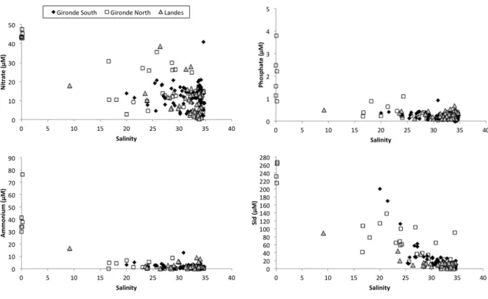
Fig. 3. Nitrate (nitrate + nitrite), ammonium, phosphate, and dissolved silica concentrations vs. salinity graphs of waters sampled on Aquitanian beaches. Beaches from Gironde North are those between Le Gurp and Carcans; beaches from Gironde South are those between Lacanau and the Arcachon lagoon; beaches from Landes include Biscarrosse and southern beaches. Samples with a salinity of 0 are waters seeping out the dune in north Gironde.
salinities close to that of sea water. Nevertheless, at all locations along the Aquitanian coast, we found waters with salinities below 34. The northern part of Gironde department was characterized by fresh water from the unconfined surficial aquifer discharging at the beach face. In the southern Gironde and in the Landes, we sampled waters with salinities down to 9, indicating that waters present in the sandy sediment of the beach were not only recirculating sea water from earlier high tides but also terrestrial groundwater mixed with sea water. Brack-ish waters were sampled in the lower part of the tidal beach, especially in seeping waters and in runnels isolated from the open sea water at low tide. Saline and brackish waters sampled on the beach aquifer were oxic with oxygen saturation between 50 and 100% (Charbonnier et al., 2013a, 2013b, 2016).
Saline pore waters of the beach contained up to 40μM of NOx (Fig. 3), whereas sea water NOx concentration was always lower than 10μM (not shown onFig. 3). Terrestrial waters seeping on the beach in the north Gironde contained between 40 and 50μM of NOx. Brackish waters had NOx concentrations between the sea water value and 40μM. For a given location, a graph of NOx versus salinity generally showed a linear relationship with an extrapolated zero-salinity end-member be-tween 40 and 50μM. We observed this trend in a runnel that was iso-lated from sea water during 2 h around low tide. The salinity of the runnel water decreased with time, while the NOx concentration in-creased (Fig. 4), suggesting that fresh or brackish water enriched in NOxflowed in the runnel. Ammonium concentrations of sea water, sa-line pore waters, and brackish waters were almost always below 10μM, whereas the terrestrial water end-member from north Gironde samples contained between 30 and 80μM of ammonium. DIP concentrations of sea, saline, and brackish waters collected on the beach were all below 1μM, whereas the freshwater end-member had a variable DIP concen-tration between 1 and 4μM depending on sampling location. For DIP, as for ammonium, we noticed no linear relationship with salinity. Dis-solved silica was generally below 40μM in saline waters. The concentra-tion increased when salinity decreased. Terrestrial waters seeping in the north Gironde beaches had concentrations between 210 and 270μM. 3.2. Truc Vert subterranean estuary
The three piezometers placed in the upper beach allowed us to sam-ple waters from the beach aquifer in two seasons, March and September 2013. The salinity of pore waters changed according to the tidal range. One piezometer was located at the level of the high spring tide water
mark. It contained saline water during spring tide periods. The salinity was at 5 during neap tides. The other piezometers, located a few metres upstream, contained brackish to fresh waters with salinities lower than 15. The NOx concentration was that of sea water when pore waters were at salinity 35. Freshwaters collected in the piezometers had a var-iable NOx concentration, ranging between 4 and 150μM, with mean concentrations of 56.5 in March and 83.3 in September. Most of the samples with intermediate salinities had intermediate nitrate concen-trations between those of the fresh and saline water end-members. The concentration of dissolved oxygen always remained above 0 in the piezometers (not shown).
Ammonium concentrations were below 2μM whatever the salinity. Only a few samples, with different salinities, showed ammonium con-centrations between 2 and 8μM. DON concentrations ranged from 0 to 180μM. This range was close to the range of concentrations measured in sea water. DIP also showed low concentrations in saline, fresh, and in-termediate water, with values below 1μM. Dissolved silica had a low sea water end-member and a more concentrated and more variable fresh-water end-member, like NOx. Sea fresh-water Si concentration was below 4μM. Pore waters with salinities above 34 generally contained more Si than sea water, with mean concentrations of 5μM in March and 26μM in September. The freshwater end-member contained between 4 and 110μM of Si, with mean values of 20 and 55 μM in March and Sep-tember, respectively. Waters with intermediate salinities had interme-diate Si concentrations, but the relationship between Si and salinity was not as linear as for NOx.
3.3. Continental groundwater
Waters collected in forest wells in uplands above the Truc Vert beach were always anoxic and contained between 13 and 240μM of dissolved iron (Fig. 5). DIN was present mostly as ammonium. Concentrations ranged between 1 and 62μM (Fig. 5). Oxidized forms of DIN were at low concentration, generally below 2μM as nitrite. Nitrate was present in two wells sampled in the forested dune anoxic aquifer in the north Gironde. DON concentrations ranged from 2 to 92μM (Fig. 5), which represented between 11 and 97% of TDN, with an average value of 63%, which is very similar to that measured in several Cape Cod water-sheds (Kroeger et al., 2006). DIP concentrations were high relative to the beach aquifer, with concentrations between 1 and 27μM, depending on location. Except for one sample, all dune aquifer samples contained more than 220μM of dissolved Si. The highest concentrations reached 570μM.
3.4. Inorganic N and P contents in rainwater
Rainwater showed variable concentrations in DIN and DIP. Both the dry and the wet years showed nitrate + nitrite and ammonium concen-trations from 0 to 120μM. We observed a linear relationship between NOx and ammonium, with a slope that was close to 1 (Fig. 6). The pre-cipitation weighted averages of nitrate + nitrite were 13.4 and 17.3μM in 2008 and 2011, respectively. The values were 7.7 and 21.1μM for am-monium and 0.12 and 0.35μM for DIP. We did not observe a marked seasonal pattern in rainwater nutrient concentrations.
4. Discussion
4.1. Water balance calculation
We detected the presence of brackish waters at every point of sam-pling along the Aquitanian coast. Therefore, the presence of seeping terrestrial-water end-members on this coast is the rule. The choice of technique to measure theflux of terrestrial water in the environment studied is limited. The use of chemical tracers such as radium or radon isotopes (Burnett and Dulaiova, 2003; Moore, 2006) to estimate the ter-restrial waterflux was precluded, because in such a high-energy open
Fig. 4. Nitrate (nitrate + nitrite) and salinity of water samples collected at low tide in an isolated runnel that received seeping brackish groundwater. The runnel was isolated from seawater at t = 0 and became more and more diluted with fresh groundwater. After 2 h, the runnel was againflooded with rising sea water. The intercept at salinity 0 corresponds to a nitrate + nitrite concentration of 42.2μM.
coastal system, it would be difficult to extract, from the inventory of a short-lived Ra isotope or 222Rn isotope, the parts due to terrestrial waterflux and sea water recirculation due to tidal pumping (Anschutz et al., 2009; Charbonnier et al., 2013b). It would even be very difficult to estimate a radioisotope inventory because of longshore currents and swell. Salinity itself cannot be used to calculate a water mass bal-ance, because of hydrodynamic conditions. Seepage meters are the only device that can be used to measure seepage directly. However, a se-rious limitation of seepage meters is the requirement that they have to be deployed in a relatively calm environment. Such devices do not oper-ate when ambient open-woper-ater currents due to waves and tides are im-portant (Corbett and Cable, 2003; Burnett et al., 2003). Breaking waves dislocate seepage meters and currents induceflow through the seabed when passing over and around obstacles (Huettel et al., 1996).
Another approach is the water balance calculation. This approach links the terrestrial aquifer with the beach through the discharge of groundwater, which is set by precipitation and evapotranspiration
over an extended period on the catchment area that drains the coastal zone directly. The watershed of the Aquitanian coast has a surface area of 822 km2(Fig. 1), based on hydrograph separation. This surface
area excludes the catchments of sparse coastal rivers and coastal lakes. Therefore, in the considered watershed, surface runoff can be neglected in the water budget calculation since there is no river, stream, or surface drainage in the catchment, and the excess rainfall is considered to go en-tirely to groundwater recharge. Groundwater pumping can also be neglected, since the numerous wells that were installed in the water-shed only serve forfighting potential wildfires. The mean precipitation of the studied site is 810 mm y−1. Evapotranspiration from the pine for-est on sand dunes represents a maximum value of 570 mm y−1(Govind et al., 2014). Thus, the hydrologic estimate of potential terrestrial groundwater recharge is at least 240 mm y−1. For the whole coastal wa-tershed, this makes approximately 200·106m3y−1. At steady state, this potential recharge can be considered as the groundwater discharge. The area over which terrestrial water discharge takes place is difficult to
Fig. 5. Nitrate (nitrate + nitrite), ammonium, phosphate (DIP), and dissolved silica concentrations vs. salinity graphs of waters sampled at Truc Vert beach in sea water, in the subterranean estuary (samples from upper beach piezometers collected in March 2013 and in September 2013), and in upland groundwater.
assess because the cross-shore length where discharge occurs varies with time and space, according to beach topography and tide amplitude. Therefore we cannot represent discharge as Darcy'sflux (e.g. cm day−1).
Nevertheless, we can express the groundwater discharge as the volume of water per unit length of shoreline (Sellinger, 1995; Povinec et al., 2012). Dividing this discharge rate by the 240 km of shoreline yields an estimated minimum discharge rate of 822 m3y−1m−1longshore
or 2.25 m3d−1m−1or 1.16 m3m−1per tide. This value is about one
order of magnitude lower than the estimate based on hydrologic water balance in a Mauritius Island lagoon (Povinec et al., 2012). Our value was of the same range as that calculated from a hydrological model for the Cockburn Sound, West Australia (Smith and Nield, 2003). The difference between locations comes from the geology, geo-morphology, and climate of the catchment (e.g.Taniguchi et al., 2006). In thefield, we visually observed variability in groundwater seepage over distances of a few metres, despite the homogeneity of sandy sedi-ment at this scale. Differences were probably due to a complex and moving structure of subterranean channels in the porous media. Our calculation provides a regional-scale water budget that does not take into account the detailed morphology that controls discharge at the local scale. There are uncertainties in all of the values used in the calcu-lations. Uncertainties are low for the mean precipitation and evapo-transpiration. The acquisition of additional hydrogeological data, particularly concerning the beach aquifer geometry, could be used to re-fine the calculation. The watershed surface area is based on hydrograph separation, which is afirst estimate. But we cannot do better for now. The estimate of the groundwaterflow is unlikely to increase but could decrease if the aquifer directly connected to the beach is smaller than estimated.
The value of the terrestrial groundwaterflow could be indepen-dently checked by performing a calculation using Darcy's law or a nu-merical hydrological model. The use of a hydrological model based on aquifer properties (permeability, hydraulic conductivity) and data on freshwater head and hydraulic gradient is a good way to assess the ter-restrial waterflow. However, this approach in coastal zones necessitates several simplifying assumptions related to the effect of water head change (Spiteri et al., 2008). Our studied site is not simple, and simpli fi-cation of models would be needed because several parameters are not available. Hydrodynamic conditions are rough, which prevents the in-stallation of piezometers in the intertidal beach section. The presence of protected high aeolian sand dunes also prevents the installation of pi-ezometers to obtain data on water head close to the beach. Therefore, we have data on the freshwater head only beyond the dune, that is, sev-eral hundred metres from the beach, while there is probably a variable hydraulic gradient between the forested dune, the foredune, and the
beach. So, data on the geometry of the studied aquifer and its evolution with seasons are not available for our site and results from a numerical model would be tainted by an inaccuracy greater than the water balance approach we used.
4.2. Nutrientfluxes
Simply multiplying the average nutrient concentration in continen-tal groundwater by the terrestrial submarine water discharge rate will lead to accuratefluxes only for conservative species. However, nutrients are not conservative species. Additional processes can add or remove N, P, and Si species at the boundary between fresh and saline waters and in the tidal beach zone.
Filtration of sea water through sandy sediments of exposed beaches supplies oxygen and marine organic matter in permeable tidal sedi-ments (Riedl and Machan, 1972; Rauch and Denis, 2008; Rocha, 2008; Dugan et al., 2011). The mineralization of this organic matter represents a source of nutrients to the shallow coastal zone (Avery et al., 2008). This process has been studied at Truc Vert beach (Anschutz et al., 2009; Charbonnier et al., 2013a). It has been shown that about 2.5 km3of sea water isfiltered each year in the sand by tidal pumping
along the 240-km-long Aquitanian beach. As a consequence, 44·106mol of NOx are released each year to the adjacent coastal zone
by this process. The intra-beach recycling of marine nitrogen explains the large range of NOx concentrations observed in samples with sea water salinities (Fig. 3). The samples with high NOx concentrations also represent waters depleted in dissolved oxygen due to aerobic respi-ration (Charbonnier et al., 2013a). These samples are also enriched in dissolved silica due to quartz dissolution. Actually, silica concentrations remain far below saturation level with respect to quartz, and pore wa-ters remain in the beach aquifer for several days (Anschutz et al., 2009). This enrichment was higher in September than in March, proba-bly because sea water was warmer, which would enhance the quartz dissolution kinetics (Dove, 1994; Anschutz et al., 2009). Saline pore wa-ters are not enriched in DIP relative to sea water, probably because DIP released from organic matter mineralization remains adsorbed on sed-iment particles.
Terrestrial groundwater constitutes an additional source of nutrients for the coastal ocean (Bowen et al., 2007). In the present study, we have sampled brackish pore waters in the seepage zone and in piezometers located in the upper Truc Vert beach. They reveal that the terrestrial groundwater end-member is enriched in nutrients (Fig. 5). We have collected three kinds of freshwaters with different nutrient concentra-tions:first, anoxic waters from wells located in the forested dune, sec-ond, oxic freshwaters from the upper beach piezometers, and third, fresh water seeping directly out of the dune in the north Gironde. Truc Vert upland wells contained DIN concentrations up to 62μM, mostly as ammonium, whereas upper beach freshwaters were depleted in am-monium but enriched in NOx up to 150μM. Seeping waters from the north Gironde were intermediate, with both NOx and ammonium. This suggests that nitrification of ammonium occurred as in other sub-terranean estuaries (Spiteri et al., 2008; Anwar et al., 2014). At our study site, however, the redox front did not correspond to the salinity gradient, because the transformation of ammonium in NOx occurred in freshwaters. This may be linked to the presence of a foredune de-pleted in organic soil. At the station where we collected seeping fresh-waters (Gurp beach), the foredune was reduced, whereas it was up to 200 m wide at Truc Vert beach. In this part of the catchment, which is directly connected to the beach aquifer, rainwater percolates in sand with few biogeochemical transformations. The redox front most likely occurs where upland groundwater meets dune groundwater. Piezome-ters installed between foredunes and the end of wooded backdunes would allow us to better characterize the groundwater redox boundary. The large range of nitrate + nitrite concentrations in the upper beach freshwaters could reflect variable concentrations of DIN in rain-waters and in the aquifer (e.g. Bowen et al., 2007). One major
Fig. 6. Nitrate (nitrate + nitrite) vs. ammonium concentrations in rainwaters collected after every precipitation episode of years 2008 and 2011 at Biganos, close to the Arcachon lagoon.
biogeochemical transformation of rainwater in the foredune aquifer is the nitrification of ammonium, since dissolved ammonium is at very low concentrations in the upper beach aquifer, whereas it is as concen-trated as NOx in rainwaters (Fig. 6). This process may be favoured by ni-trifying bacteria present in the sandy sediment. This process consumes dissolved oxygen with a stoichiometric ratio of two O2for one
ammo-nium nitrified to NOx. Considering the weighted average ammonium concentration of 21.1μM, which was the high value in 2011, nitrification would consume 42.2μM of dissolved O2, which is not enough to shift
rainwater to anoxia. Ammonium may also be adsorbed on particles dur-ing passage through sediments. Sorption by cation exchange reactions at negatively charged clay mineral surfaces may control ammonium mi-gration in aquifers (Buss et al., 2004; Lorah et al., 2009). The cationic ex-change capacity reported for sands sampled in the same geological setting is close to 1 meq 100 g−1(Canton et al., 2010). This value is low, but may support a partial retention of ammonium.
Since nitrification of ammonium occurs in the terrestrial freshwater aquifer, the concentration of NOx in the salinity range of 1–35 is approx-imately conservative between low concentrations at salinity 35 and a mean concentration of about 40–50 μM in the terrestrial water end-member (Figs. 4 and 5). This end-member has been measured at Truc Vert beach and in other places on the Aquitanian coast (Fig. 2), suggest-ing that it is relatively constant. Nitrate + nitrite is nearly ubiquitous in oxic groundwater and travels through aquifers with minimal physical retention (Capone and Bautista, 1985). Therefore an up-scaling of the DINflux from terrestrial groundwater discharge can be assessed. Considering a mean DIN concentration of 45μM for the terrestrial water end-member and a minimum annual groundwater flux of 200·106 m3 y−1, we obtain a DIN flux from terrestrial SGD of
9·106mol (126 tonnes) each year to the adjacent coastal zone. This
flux is lower than the release of DIN due to tidally driven recycled sea water, which results from the recycling of a mean concentration of 17.4 ·M of DIN in 2500·106m3y−1of recirculating sea water (i.e.
600 tonnes of DIN y−1,Charbonnier et al., 2013a). It is much lower than the meanflux of DIN coming from the rivers of the Aquitanian coast (N30,000 t), because the surface of the beach catchment is much lower than river catchments. Nevertheless, the SGDflux contributes to a diffuse input of available and new DIN to the marine environment all along the coastal zone, which could impact the microbial community (Garcés et al., 2011).
Dissolved organic nitrogen concentrations ranged from 0 to 100μM in both terrestrial freshwaters and sea water. DON concentrations in the salinity gradient are between both end-members, except some samples in the 0–10 salinity interval, which are enriched in DON, like DIN, sug-gesting additional input of DON in the redox front. DON, which repre-sents a mean proportion of 63% of TDN in the terrestrial end-member, is the dominant form of N exported to the coastal zone (Kroeger et al., 2006). The direct impact of DON export from terrestrial SGD on coastal water biogeochemistry depends on the bioavailability and/or minerali-zation of DON, which can be low in coastal zones (Seitzinger et al., 2002; Agedah et al., 2009).
Dissolved phosphate concentrations were between 1 and 27μM in the forested dune aquifer. They were also above 1μM where freshwa-ters seeped directly on the beach (north Gironde). They were below 1μM in freshwaters collected in Truc Vert beach piezometers. Freshwa-ters enriched in DIP were anoxic and contained dissolved iron. Dis-solved iron is probably oxidized at the redox front in the foredune aquifer, where ammonium is nitrified. As a result, authigenic iron oxides may trap DIP by an adsorption process. The so-called“iron curtain” (Charette and Sholkovitz, 2002; Spiteri et al., 2008) leads to the removal of phosphate. This process consumes dissolved oxygen with a stoichio-metric ratio of one O2to four Fe(II) oxidized to Fe(III)-oxide.
Consider-ing the maximum Fe(II) concentration of 240μM measured in upland wells, iron oxidation would consume 60μM of dissolved O2, which is
not enough to shift O2-saturated freshwaters to anoxia at the redox
front.
At the redox front, the efficiency of the process of phosphate removal depends on the Fe(II)/DIP ratio (Griffoen, 1994).Anschutz et al. (2007)
showed that phosphate was quantitatively adsorbed when the ratio exceeded 5. In our case, the Fe(II)/DIP ratio in forest aquifer was above 6 and up to 40, except in one single well, where the mean value was 3.5. Therefore, DIP was potentially totally adsorbed on iron oxides. As a consequence, terrestrial groundwater was not a source of phosphate for the coastal ocean. This also implies that a large quantity of P is trapped at the present-day redox boundary. The shifting of this bound-ary for any reason, such as sea level rise, upland groundwater use, or erosion of the bare foredune, would cause a release of P through reduc-tive dissolution of Fe-oxides. The direct seepage on the beach of iron-and DIP-rich freshwaters in the north Gironde is probably a conse-quence of dune erosion, which is known to occur there (Aubie and Tastet, 2000).
Dissolved silica in upland wells was far above supersaturation with respect to quartz. At the maximal temperature measured in wells (16 °C), the quartz solubility was 138μM of H4SiO4(Gunnarsson and Arnorsson, 2000). On the other hand, Si concentrations were below the solubility of amorphous silica, which was at 1600μM. Therefore the concentration of Si in groundwater did not result from the dissolu-tion of the quartz-bearing aquifer but most likely from phytoliths re-leased from the breakdown of plant organic matter (Gerard et al., 2008). The dissolved silica concentration measured in fresh water from the Truc Vert beach piezometers was below the value measured in the upland aquifer end-member. A part of the missing Si may have co-precipitated with iron oxides. However, the missing Si was above the concentration of dissolved Fe(II) in groundwater, suggesting that the co-precipitation process was not the dominant process of Si re-moval. Here, upland aquifer freshwater was most likely partly diluted with foredune pore waters that were not enriched in Si from biogenic amorphous silica dissolution.
5. Conclusions
According toZektser and Loaiciga (1993), only approximately 2% of global precipitation is channelled into direct groundwater discharge to the ocean. The beach catchment studied here represents less than 1% of the watershed of the large rivers of southwest France (Dordogne, Garonne, Leyre, Adour;Fig. 1) thatflow into the Bay of Biscay. The contribution of terrestrial SGD based on the water balance approach also represents less than 1% of the regional water budget. The nitrate + nitrite concentration of the upper beach freshwater end-member is lower than that of the above mentioned rivers. Therefore, terrestrial SGD may not rival river input in the studied region. One rea-son for the low DINflux from SGD is the land use, which consists almost exclusively of forested and bare sand dunes. It is likely that land uses that are more detrimental for water quality, such as agriculture or waste water infiltration, would have a higher impact on DIN fluxes from SGD (Slomp and Van Cappellen, 2004; Kroeger et al., 2006; Canton et al., 2010). Treated waste water infiltration plants have been recently implemented in the forested sand dune aquifer close to the small villages situated upland. The DIN concentration of SGD located on beaches downstream of these plants should be monitored to follow their possible impact on nutrient input to the coast. Nevertheless, ter-restrial SGD is a net source of NOx all along the sandy Aquitanian coast. This makes an additional source of NOx to the one originating from sea water circulation in the tidal beach zone (Charbonnier et al., 2013a). Both sources increase the N/P ratio of available nutrients.
The subterranean estuary studied here, that is, the subterranean sa-linity front, is not a redox front. Terrestrial groundwater of the surficial aquifer of the upland forested dune is anoxic. Freshwaters from the un-confined upper beach surficial aquifer are oxic: the redox front occurs upstream of the saline front, below the foredune depleted in organic soil. Groundwater ammonium is nitrified and phosphate is trapped on iron oxides that precipitate at this redox boundary.
Acknowledgements
The authors gratefully acknowledge several colleagues and students who helped us at the study site during the differentfield experiments (Thomas Smith, Marie Wawrzykowski, Sandrine Cassous-Ribehart, Mathilde Leymarie, Mathieu Canton, Stéphane Bujan). The French Na-tional Programs EC2CO—MOBISEA and ESTAFET (CNRS—INSU) and the ANR-06-BLAN PROTIDAL funded this study. This study has been carried out in the frame of the Investments for the future Program, within the Cluster of Excellence COTE (ANR-10-LABEX-45).
References
Agedah, E.C., Binalaiyifa, H.E., Ball, A.S., Nedwell, D.B., 2009.Sources, turnover and bio-availability of dissolved organic nitrogen (DON) in the Colne estuary, UK. Mar. Ecol. Prog. Ser. 382, 23–33.
Anderson, L., 1979.Simultaneous spectrophotometric determination of nitrite and nitrate byflow injection analysis. Anal. Chim. Acta 110, 123–128.
Anschutz, P., Chaillou, G., Lecroart, P., 2007.Phosphorus diagenesis in the sediment of the Thau Lagoon. Estuar. Coast. Shelf Sci. 72, 447–456.
Anschutz, P., Smith, T., Mouret, A., Deborde, J., Bujan, S., Poirier, P., Lecroart, P., 2009.Tidal sands as biogeochemical reactors. Estuar. Coast. Shelf Sci. 84, 84–90.
Anwar, N., Robinson, C., Barry, D.A., 2014.Influence of tides and waves on the fate of nu-trients in a nearshore aquifer: numerical simulations. Adv. Water Resour. 73, 203–213.
Aubie, S., Tastet, J.-P., 2000.Coastal erosion, processes and rates: an historical study of the Gironde coastline, southwestern France. J. Coast. Res. 16 (3), 756–767.
Avery Jr., G.B., Kieber, R.J., Taylor, K.J., 2008.Nitrogen release from surface sand of a high energy beach along the southeastern coast of North Carolina, USA. Biogeochemistry 89 (3), 357–365.
Banks, W., Paylor, R., Hughes, W., 1996.Using thermal infrared imagery to delineate groundwater discharge. Groundwater 34, 434–443.
Berner, E.K., Berner, R.A., 1987.The Global Water Cycle. Prentice-Hall, Englewood Cliffs, NJ.
Billerbeck, M., Werner, U., Bosselmann, K., Walpersdorf, E., Huettel, M., 2006.Nutrient re-lease from an exposed intertidal sandflat. Mar. Ecol. Prog. Ser. 316, 35–51.
Bosch, J.M., Hewlett, J.D., 1982.A review of catchment experiments to determine the ef-fect of vegetation changes on water yield and evapotranspiration. J. Hydrol. 55, 3–23.
Bowen, J.L., Kroeger, K.D., Tomasky, G., Pabich, W.J., Cole, M.L., Carmichael, R.H., Valiela, I., 2007.A review of land-sea coupling by groundwater discharge of nitrogen to New England estuaries: mechanisms and effects. Appl. Geochem. 22, 175–191.
Burnett, W.C., Dulaiova, H., 2003.Estimating the dynamics of groundwater input into the coastal zone via continuous radon-222 measurements. J. Environ. Radioact. 69, 21–35.
Burnett, W.C., Bokuniewicz, H., Huettel, M., Moore, W.S., Taniguchi, M., 2003. Groundwa-ter and pore waGroundwa-ter inputs to the coastal zone. Biogeochemistry 66, 3–33.
Burnett, W.C., Aggarwal, P.K., Aureli, A., Bokuniewicz, H., Cable, J.E., Charette, M.A., Kontar, E., Krupa, S., Kulkarni, K.M., Loveless, A., Moore, W.S., Oberdorfer, J.A., Oliveira, J., Ozyurt, N., Povinec, P., Privitera, A.M.G., Rajar, R., Ramessur, R.T., Scholten, J., Stieglitz, T., Tanigushi, M., Turner, J.V., 2006.Quantifying submarine groundwater dis-charge in the coastal zone via multiple methods. Sci. Total Environ. 367, 498–543.
Buss, S.R., Herbert, A.W., Morgan, P., Thornton, S.F., Smith, J.W.N., 2004.A review of am-monium attenuation in soil and groundwater. Q. J. Eng. Geol. Hydrogeol. 37 (4), 347–359.
Butel, R., Dupuis, H., Bonneton, P., 2002.Spatial variability of waves conditions on the French Aquitanian coast using in-situ data. J. Coast. Res. 36, 96–108.
Canton, M., Anschutz, P., Naudet, V., Molnar, N., Mouret, A., Francecshi, M., Naessens, F., Poirier, D., 2010.Impact of a solid waste disposal on nutrient dynamics in a sandy catchment. J. Contam. Hydrol. 116, 1–15.
Canton, M., Anschutz, P., Coynel, A., Polsenaere, P., Auby, I., Poirier, D., 2012.Nutrient ex-port to an Eastern Atlantic coastal zone:first modeling and nitrogen mass balance. Biogeochemistry 107, 361–377.
Capone, D.G., Bautista, M.F., 1985.A groundwater source of nitrate in nearshore marine sediments. Nature 313, 214–216.
Castelle, B., Bonneton, P., Dupuis, H., Sénéchal, N., 2007.Double bar beach dynamics on the high-energy meso-macrotidal French Aquitanian Coast: a review. Mar. Geol. 245, 141–159.
Charbonnier, C., Anschutz, P., Poirier, D., Bujan, S., Lecroart, P., 2013a.Aerobic respiration in a high-energy sandy beach. Mar. Chem. 155, 10–21.
Charbonnier, C., Anschutz, P., Deflandre, B., Poirier, D., Bujan, S., Lecroart, P., 2013b. Influ-ence of physical forcing on pore water properties of a tidal sandy beach (TrucVert, Aquitaine, France). Coast. Dynamics 33.
Charbonnier, C., Anschutz, P., Deflandre, B., Poirier, D., Bujan, S., Lecroart, P., 2016. Measur-ing pore water oxygen of a high-energy beach usMeasur-ing buried probes. Estuar. Coast. Shelf Sci.http://dx.doi.org/10.1016/j.ecss.2015.12.004.
Charette, M.A., Sholkovitz, E.R., 2002.Oxidative precipitation of groundwater-derived fer-rous iron in the subterranean estuary of a coastal bay. Geophys. Res. Lett. 29, 1444–1447.
Charette, M.A., Buesseler, K.O., Andrews, J.E., 2001.Utility of radium isotopes for evaluat-ing the input and transport of groundwater-derived nitrogen to a Cape Cod estuary. Limnol. Oceanogr. 46, 465–470.
Corbett, D.R., Cable, J.E., 2003.Seepage meters and advective transport in coastal environ-ments: comments on“seepage meters and Bernoulli's revenge” by E.A. Shinn, C.D. Reich, and T.D. Hickey. Estuaries 26 (5), 1383–1389.
Deborde, J., Anschutz, P., Auby, I., Glé, C., Commarieu, M.V., Maurer, D., Lecroart, P., Abril, G., 2008.Role of tidal pumping on nutrient cycling in a temperate lagoon (Arcachon Bay, France). Mar. Chem. 109 (1–2), 98–114.
Dove, P.M., 1994.The dissolution kinetics of quartz in sodium chloride solutions at 25 °C to 300 °C. Am. J. Sci. 294, 665–712.
Dugan, J.E., Hubbard, D.M., Page, H.M., Schimel, J.P., 2011.Marine macrophyte wrack in-puts and dissolved nutrients in beach sands. Estuar. Coasts 34 (4), 839–850.
Fischer, W.A., Moxham, R.M., Polcyn, F., Landis, G.H., 1964.Infrared surveys of Hawaiian volcanoes. Science 146, 733–742.
Garcés, E., Basterretxea, G., Tovar-Sánchez, A., 2011.Changes in microbial communities in response to submarine groundwater input. Mar. Ecol. Prog. Ser. 438, 47–58.
Garrels, R.M., MacKenzie, F.T., 1971.Evolution of Sedimentary Rocks. Norton and Co., New York, p. 397 pp.
Gerard, F., Mayer, K.U., Hodson, M.J., Ranger, J., 2008.Modeling the biogeochemical cycle of silicon in soils: application to a temperate forest ecosystem. Geochim. Cosmochim. Acta 72, 741–758.
Govind, A., Cowling, S., Kumari, J., Rajan, N., Al-Yaari, A., 2014.Distributed modeling of ecohydrological processes at high spatial resolution over a landscape having patches of managed forest stands and cropfields in SW Europe. Ecol. Model. 297, 126–140.
Griffoen, J., 1994.Uptake of phosphate by iron hydroxides during seepage in relation to development of groundwater composition in coastal areas. Environ. Sci. Technol. 28, 675–681.
Gunnarsson, I., Arnorsson, S., 2000.Amorphous silica solubility and the thermodynamic properties of H4SiO4in the range of 0° to 350 °C at Psat. Geochim. Cosmochim. Acta
64 (13), 2295–2307.
Huettel, M., Ziebis, W., Forster, S., 1996.Flow-induced uptake of particulate matter in per-meable sediments. Limnol. Oceanogr. 41 (2), 309–322.
Knee, K.L., Paytan, A., 2011.Submarine groundwater discharge: a source of nutrients, metals and pollutants to the coastal ocean. In: Wolanski, E., Mclusky, D.S. (Eds.), Trea-tise on Estuarine and Coastal Science. 4, pp. 205–233.
Kroeger, K.D., Charette, M.A., 2008.Nitrogen biogeochemistry of submarine groundwater discharge. Limnol. Oceanogr. 53 (3), 1025–1039.
Kroeger, K.D., Cole, M.L., Valiela, I., 2006.Controls on groundwater-transported dissolved organic nitrogen and nitrate yields from coastal watersheds. Limnol. Oceanogr. 51, 2248–2261.
Kwon, E.Y., Kim, G., Primeau, F., Moore, W.S., Cho, H., Devries, T., Sarmiento, J.L., Charette, M.A., Cho, Y., 2014. Global estimate of submarine groundwater discharge based on an observationally constrained radium isotope model. Geophys. Res. Lett. 41 (23), 8438–8444.http://dx.doi.org/10.1002/2014GL061574.
Lee, Y.-W., Kim, G., Lim, W.A., Hwang, D.W., 2010.A relationship between submarine groundwater-borne nutrients traced by Ra isotopes and the intensity of dinoflagellate red-tides occurring in the southern sea of Korea. Limnol. Oceanogr. 55, 1–10.
Legigan, P., 1979.L'élaboration de la formation du sable des Landes, dépot résiduel de l'environnement sédimentaire pliocène-pléistocène centre aquitain. Thesis. Université de Bordeaux, Bordeaux, p. 429 pp.
Lévêque, P.C., Gros, J.-C., Maurin, C., Sévérac, J., Siméon, C., Viguier, C., 1972.Utilisation de la télédétection infrarouge et des mesures isotopiques– tritium et oxygène 18- pour l'étude des résurgences d'eau le long du littoral aquitain. C. R. Acad. Sci. Paris 274, 2841–2844.
Lorah, M.M., Cozzarelli, I.M., Böhlke, J.K., 2009.Biogeochemistry at a wetland sediment-alluvial aquifer interface in a landfill leachate plume. J. Contam. Hydrol. 105 (3–4), 99–117.
Loveless, A.M., Oldham, C.E., 2010.Natural attenuation of nitrogen in groundwater discharging through a sandy beach. Biogeochemistry 98 (1–3), 75–87.
McLachlan, A., Brown, A.C., 2006.The Ecology of Sandy Shores. Academic Press, Burling-ton, Massachusetts.
Michael, H.A., Lubetsky, J.S., Harvey, C.F., 2003.Characterizing submarine groundwater discharge: a seepage meter study in Waquoit Bay, Massachusetts. Geophys. Res. Lett. 30 (6), 1297.
Michel, D., Howa, H., 1999.Short-term morphodynamic response of a ridge and runnel system on a mesotidal sandy beach. J. Coast. Res. 15, 428–437.
Moore, W.S., 2006.The role of submarine groundwater discharge in coastal biogeochem-istry. J. Geochem. Explor. 88 (1–3), 389–393.
Moore, W.S., 2010.The effect of submarine groundwater discharge on the ocean. Ann. Rev. Mar. Sci. 2 (1), 59–88.
Mullin, J.B., Riley, J.P., 1955.The spectrophotometric determination of silicate-silicon in natural waters with special reference to sea water. Anal. Chem. Acta 12, 162–170.
Murphy, J., Riley, J.P., 1962.A modified single solution method for determination of phos-phate in natural waters. Anal. Chim. Acta 42, 31–36.
Pitaud, G., 1967.L'hydrogéologie et la végétation dans les dunes du littoral aquitain. The-sis, University Bordeaux no. 460 149 pp.
Povinec, P.P., Burnett, W.C., Beck, A., Bokuniewicz, H., Charette, M.A., Gonneea, M.E., Groening, M., Ishitobi, T., Kontar, E., Liong Wee Kwong, L., Marie, D.E.P., Moore, W.S., Oberdorfer, J.A., Peterson, R., Ramessur, R., Rapaglia, J., Stieglitz, T., Top, Z., 2012.Isotopic, geophysical and biogeochemical investigation of submarine ground-water discharge: IAEA-UNESCO intercomparison exercise at Mauritius island. J. Environ. Radioact. 104 (1), 24–45.
Rauch, M., Denis, L., 2008.Spatio-temporal variability in benthic mineralization processes in the eastern English Channel. Biogeochemistry 89, 163–180.
Riedl, R.J., Machan, R., 1972.Hydrodynamic patterns in lotic intertidal sands and their bioclimatological implications. Mar. Biol. 13, 179–209.
Rocha, C., 2008.Sandy sediments as active biogeochemical reactors: compounds cycling in the fast lane. Aquat. Microb. Ecol. 53, 119–127.
Roxburgh, I.S., 1985.Thermal infrared detection of submarine spring associated with the Plymouth Limestone. Hydrol. Sci. J. 30, 185–196.
Santos, I.R., Burnett, W.C., Chanton, J., Mwashote, B., Suryaputra, I.G.N.A., Dittmar, T., 2008.
Nutrient biogeochemistry in a Gulf of Mexico subterranean estuary and groundwater-derivedfluxes to the coastal ocean. Limnol. Oceanogr. 53 (2), 705–718.
Seitzinger, S.P., Sanders, R.W., Styles, R., 2002.Bio-availability of DON from natural and anthropogenic sources to estuarine plankton. Limnol. Oceanogr. 47, 353–366.
Sellinger, C.E., 1995.Groundwaterflux into a portion of eastern Lake Michigan. J. Great Lakes Res. 21, 53–63.
Short, A.D., 1991.Macro-meso tidal beach morphodynamics- an overview. J. Coast. Res. 7, 417–436.
Short, A.D., Aagaard, T., 1993.Single- and multi-bar beach change models. J.Coast. Res. SI15 141–157.
Slomp, C.P., Van Cappellen, P., 2004.Nutrients inputs to the coastal ocean through subma-rine groundwater discharge: controls and potential impact. J. Hydrol. 295, 64–86.
Smith, A.J., Nield, S.P., 2003.Groundwater discharge from the superficial aquifer into Cockburn Sound Western Australia: estimation by inshore water balance. Biogeo-chemistry 66, 125–144.
Spiteri, C., Slomp, C.P., Tuncay, K., Meile, C., 2008.Modeling biogeochemical processes in subterranean estuaries: effect offlow dynamics and redox conditions on submarine groundwater discharge of nutrients. Water Resour. Res. 44 (2), 1–18.
Stookey, L.L., 1970.Ferrozine-a new spectrophotometric reagent for iron. Analytica Anal. Chem. Acta 42, 779–781.
Strickland, J.D.H., Parsons, T.R., 1972.A practical handbook of sea water analysis. Fish. Res. Board Can. Bull. 167, 1–31.
Taniguchi, M., Fukuo, Y., 1993.Continuous measurements of groundwater seepage using an automated seepage meter. Ground Water 31, 675–679.
Taniguchi, M., Burnett, W.C., Dulaiova, H., Kontar, E.A., Povinec, P.P., Moore, W.S., 2006.
Submarine groundwater discharge measured by seepage meters in Sicilian coastal waters. Cont. Shelf Res. 26, 835–842.
Ullman, W.J., Chang, B., Miller, D.C., Madsen, J.A., 2003.Groundwater mixing, nutrient dia-genesis, and discharges across a sandy beachface, Cape Henlopen, Delaware (USA). Estuar. Coast. Shelf Sci. 57, 539–552.
Valderrama, J.C., 1981.The simultaneous analysis of total nitrogen and total phosphorus in natural waters. Mar. Chem. 10, 109–122.
Vertessy, R.A., Zhang, L., Dawes, W.R., 2003.Plantations, riverflows and river salinity. Aust. For. 66, 55–61.
Zektser, I.S., Loaiciga, H.A., 1993.Groundwaterfluxes in the global hydrologic cycle: past, present, and future. J. Hydrol. 144, 405–427.
Zimmermann, C.F., Montgomery, J.R., Carlson, P.R., 1985.Variability of dissolved reactive phosphateflux rates in nearshore estuarine sediments: effects of groundwater flow. Estuaries 8 (2), 228–236.