HAL Id: hal-02140378
https://hal.archives-ouvertes.fr/hal-02140378
Submitted on 27 May 2019
HAL is a multi-disciplinary open access
archive for the deposit and dissemination of
sci-entific research documents, whether they are
pub-lished or not. The documents may come from
teaching and research institutions in France or
abroad, or from public or private research centers.
L’archive ouverte pluridisciplinaire HAL, est
destinée au dépôt et à la diffusion de documents
scientifiques de niveau recherche, publiés ou non,
émanant des établissements d’enseignement et de
recherche français ou étrangers, des laboratoires
publics ou privés.
Neural network modeling and geochemical wateranalyses
to understand and forecast karst and non-karstpart of
flash floods (case study on theLezriver,Southern France)
T. Darras, F. Raynaud, V. Borrell Estupina, L. Kong-A-Siou, S. Van-Exter,
B. Vayssade, A. Johannet, S. Pistre
To cite this version:
T. Darras, F. Raynaud, V. Borrell Estupina, L. Kong-A-Siou, S. Van-Exter, et al.. Neural network
modeling and geochemical wateranalyses to understand and forecast karst and non-karstpart of flash
floods (case study on theLezriver,Southern France). Proceedings of the International Association of
Hydrological Sciences, Copernicus Publications, 2015, 369, pp.43-48. �10.5194/piahs-369-43-2015�.
�hal-02140378�
Proc. IAHS, 369, 43–48, 2015 proc-iahs.net/369/43/2015/ doi:10.5194/piahs-369-43-2015
© Author(s) 2015. CC Attribution 3.0 License.
Open Access
Hydrological
Ev
ents
(JH01
–
IUGG2015)
Neural network modeling and geochemical water
analyses to understand and forecast karst and non-karst
part of flash floods (case study on the Lez river,
Southern France)
T. Darras1,2, F. Raynaud2, V. Borrell Estupina2, L. Kong-A-Siou3, S. Van-Exter4, B. Vayssade1, A. Johannet1, and S. Pistre2
1École des mines d’Alès, 6 avenue de Clavières, 30319 Alès CEDEX, France
2Hydrosciences Montpellier, Université de Montpelier II, 2 Place Eugène Bataillon, 34095 Montpellier CEDEX 5, France
3MAYANE, 173 chemin de Fescau, 34980 Montferrier-sur-Lez, France
4Hydrosciences Montpellier, CNRS, Montpellier, 2 Place Eugène Bataillon, 34095 Montpellier CEDEX 5, France
Correspondence to: V. Borrell Estupina (Valerie.Borrell@um2.fr) Received: 21 April 2015 – Accepted: 21 April 2015 – Published: 11 June 2015
Abstract. Flash floods forecasting in the Mediterranean area is a major economic and societal issue.
Specifi-cally, considering karst basins, heterogeneous structure and nonlinear behaviour make the flash flood forecasting very difficult. In this context, this work proposes a methodology to estimate the contribution from karst and non-karst components using toolbox including neural networks and various hydrological methods. The chosen case study is the flash flooding of the Lez river, known for his complex behaviour and huge stakes, at the gauge station of Lavallette, upstream of Montpellier (400 000 inhabitants). After application of the proposed methodology, dis-charge at the station of Lavalette is spited between hydrographs of karst flood and surface runoff, for the two events of 2014. Generalizing the method to future events will allow designing forecasting models specifically for karst and surface flood increasing by this way the reliability of the forecasts.
1 Introduction
Flash floods are intense and sudden hydrologic responses of small basins to huge rainfall events. During the past 20 years in southern France they caused more than 100 fatalities and several billions euros of damages. Although, numerous stud-ies have been devoted to flash flooding, hydrologic mecha-nisms generating flash floods are yet misunderstood. Specif-ically in case of mixed, karst/non-karst basins, the role of the karst part of the basin is generally unknown. In this context, the aim of this study is thus to improve understanding of karst hydrosystems behaviour during flash flooding. As generally karst basins boundaries are not superposed to those of the surface watershed and have different dynamics, it seems in-teresting to estimate two different floods: the surface flood
and the underground flood, both being finally blended in rivers. To this end, and as it is generally impossible to achieve these measurement on flash floods downstream of the basin, because of the intensity of flood, we propose in this study a methodology which allows to propagate measurements made on or near karst springs (lower discharge) to build discharge at the outlet of the considered basin. First we propose to build a conceptual model of the hydrosystem behaviour (sur-face watershed and underground basin) and a mathematical expression of the mixture of the two kinds of water. After that, chemical analysis of water near principal karst springs (if there are several springs) allows to estimate relative karst and non-karst contributions to flood. Third, floods coming from different parts of the watershed are propagated towards the outlet using hydrologic models, and the model of mixture
44 T. Darras et al.: Case study on the Lez river
elaborated in the first part is used to estimate the total con-tribution of karst and no-karst parts of the flood. To illustrate the methodology, a case-study is chosen on the Lez hydrosys-tem, well known for its flash floods and important karst role. The Lez karst river crosses the conurbation of Montpellier (400 000 inhabitants), providing great damages, and is sub-jected to strongly heterogeneous and anisotropic water circu-lation providing highly nonlinear hydrodynamic behaviour.
The paper is thus organized as follows: first, in Sect. 2, the Lez hydrosystem is presented in order to introduce the de-sign of the postulated model and the rainfall-runoff series. In Sect. 3 the behaviour of the hydrosystem is designed thanks to an original utilization of neural networks modelling. In Sect. 4 the propagation of both karst water and surface water is done up to the gauge station of Lavalette. Section 5 allows proposing hydrographs visualizing karst and non-karst con-tributions. It must be underlined that this study suffers from a lot of approximations and uncertainties due to the lack of measurements; nevertheless it represents a mandatory work preliminary to field works and exhaustive data acquisitions. Targeted field works and measurements, combined with pro-posed methodology will lead to more accurate estimation of karst contribution to floods, and by this way, to flash flood forecasting improvement.
1.1 Case study: the Lez aquifer
The Lez aquifer is a Mediterranean karst system located in southeastern France, upstream Montpellier (Fig. 1). The Lez Spring is the main outlet of this aquifer and the Lez river crosses Montpellier conurbation. Several intermittent springs also exist, among which the Lirou Spring is the most im-portant. In this work we will take in consideration the Lez watershed at Lavalette station, at the entrance of Montpel-lier, about 120 km2, its sub-watershed, the Triadou water-shed, outlet of the Triadou Spring, about 85 km2; and the hydrogeologic basin of around 380 (Bérard, 1983) (Fig. 1).
1.2 Geological settings
As most of karst system, the Lez system is composed of karst and non-karst components. The karst component is princi-pally located in the northwestern part of the system. It is com-posed of Cretaceous and Jurassic carbonate rocks. These for-mations widely outcrop and form the calcareous plateaus of both Causse de l’Hortus and Causse de Viols-le-Fort (Fig. 1). The Causse de l’Hortus is a perched aquifer. The south-eastern part of the system, principally impervious, is com-posed of Eocene formations as carbonates and clays, and tertiary formations as sandstones, and conglomerates. The major Corconne fault crosses the Lez hydrogeological basin leading to contrasted hydrogeological behaviours.
Figure 1.Map of the Lez hydrosystem with location of Le Triadou and Lavalette gauging station, Lez Spring and Lirou Spring.
1.3 Hydrogeological settings
The principal aquifer stands in well karstified upper Juras-sic and lower Cretaceous limestones. Its bottom limit is the marl and marly limestone layer of the Callovo-Oxfordian formation. Under this layer, thick from 20 to 150 m, stands the middle Jurassic limestone and dolomite aquifer (Bérard, 1983; Marjolet and Salado, 1978). Tectonic accidents affect-ing the Callovo-Oxfordian layer make water circulation be-tween the both aquifer possible. This water exchanges are not accurately quantified. However, Caetano Bicalho (2010) and Marjolet and Salado (1978) has assessed proportion of water at the Lez Spring coming from the deepest aquifer using both major and trace elements measurements.
The principal aquifer outcrops at the South-West of Lez system (Causse de Viols-le-Fort). Its upper boundary is the lower Valanginian, which outcrops on eastern and northern parts of the Lez system (Fig. 1). The karst aquifer is thus con-fined under these impervious layers. Infiltration downward aquifer mainly occurred in its southwestern part.
1.4 Underground circulations
The Corconne Fault has contrasted roles: in the South part of the basin it behaves as a dam between eastern and west-ern parts of the aquifer. In the North part, it has a drain role thanks to several sinkholes along the fault and its satellites. Communication between northwestern part towards the Lez Spring were proved by coloration experiments (Marjolet and Salado, 1978).
Based on these findings, a zone division of the Lez basin in four parts has been proposed by Kong-A-Siou et al. (2013) (Fig. 1). The geological composition of each zone is assumed to be “homogeneous”, which means that geological similar-ity is greater inside each zone than outside. The eastwest-ern division is based on Corconne Fault. On the westeastwest-ern
side of the basin, south-north division has been drawn based on Causse de Viols-le-Fort boundary. On eastern side south-northen division has been drawn thanks to infiltration prop-erties based on high density of fractures.
1.5 Climate and meteorology
The Lez climate is Mediterranean, characterized by two rainy seasons during spring and autumn. Mediterranean rainy events are generally intense and localized providing hetero-geneous rainfalls. Heterohetero-geneous rainfall increases thus the sensitivity of the hydrologic response to the location of the rainfalls. It is thus necessary to be able to consider the loca-tion of rainfalls and the role of karst and non-karst parts of the basin on infiltration properties.
1.6 Database
Database contains one-hour time step data: (i) rainfalls at 5 rain gauges inside or near the basin in order to take into ac-count the heterogeneity of rainfalls, and discharges at Laval-lette for 15 intense floods before 2010, and 3 intense floods after 2010. Moreover chemical data are available only for the two last events of 2014 (Table 1). Table 1 focuses on the last events which were investigated in the present work.
1.7 Lez Flash floods at Lavalette
Operational flash flood forecasting and early-warning consti-tute an important field of research (Borga et al., 2011; Price et al., 2011). The task is difficult due to: (i) the lack of knowl-edge about hydrological processes involved in flash flooding (ii) uncertainty on the rain forecasts, (iii) great noise and un-certainty on measurements especially for the flood peak. In karst system these difficulties are increased due to the neces-sity to take into account underground process as karst can reduce or increase flood, depending on its saturation prior the event (Jourde et al., 2007; De Waele et al., 2010; Bailly-Comte et al., 2012; Coustau et al., 2012) at the Lavalette sta-tion.
Regarding the Lez floods at Lavalette and considering the high velocity of flash flood genesis, it can be assumed that runoff is the major contributor. Nevertheless, the karst con-tribution is significant and can worsen significantly the flood. We thus propose a methodology able to estimate separately karst flood and surface flood in order to design two differ-ent predictors, for example with neural networks models, as shown by Kong-A-Siou et al. (2011a). The methodology pro-poses several steps each one achieved and described in this paper in a specific section: (i) establishment of the conceptual model of the basin behaviour (surface and karst), (ii) chem-ical analysis in order to quantify karst and non karst water, at key points of the basin, were floods don’t prevent from making measurements in safe conditions, (iii) propagation of karst and non karst flood up to the outlet of the watershed,
Figure 2.Median and total spread (%) of respectively northwest-ern, northeastnorthwest-ern, southwestern and southeastern zone contributions versus time.
and finally (iv) reconstitution of the both karst and non karst floods.
1.8 Elaboration of the conceptual model of the Lez hydrosystem
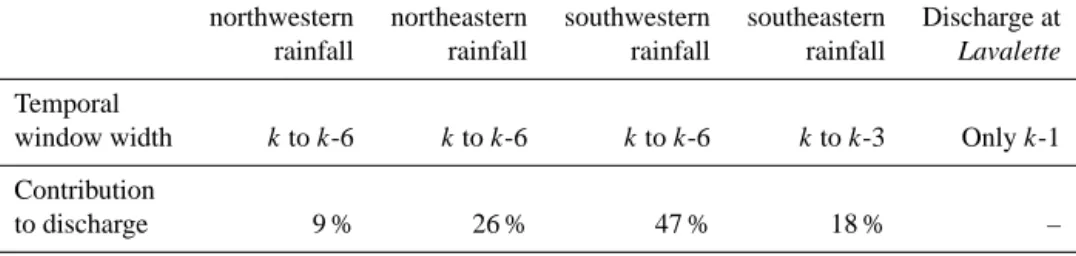
Conceptual modelling of the Lez hydrosystem behaviour us-ing neural networks (KnoX method) (Kong-A-Siou et al., 2013) proposed a method able to estimate the contribution of each one of the four zones of the Lez basin to the dis-charge at the Lez Spring, with daily time step. It appeared that the two northern zones were the most contributory zones to the discharge, sometimes with a 3-day time transfer. Darras et al. (2014) revisited this work at different time and space scales: time step was the hour and only flash floods on the whole basin at Lavalette were considered. The discharge at Lavalette have thus been simulated using artificial neural net-work fed by mean rainfall, for each of the four zones on sev-eral previous time steps, and the previous observed discharge (feed-forward model). The time window widths of previous rainfalls have been sized using method used by Kong-A-Siou et al. (2011b). Table 2 shows the temporal window width of each rainfall zone. Then, as proposed by Kong-A-Siou et al. (2013), model parameters have been analysed to establish contribution of each zone, at each time step of their temporal window width.
One can note on Fig. 2 that northwestern zone (Causse de l’Hortus) has the least contribution and, considering uncer-tainties on the data, can consequently be excluded from the model. The main contributor is the southwestern zone (al-most 50 % on the whole rainfall contribution). The northeast-ern and southwestnortheast-ern zones both show two peaks of contribu-tion. It seems coherent to attribute the first peak to the surface runoff and the second peak to the karst one, which is slower. One can note that northeastern and southwestern zones are
46 T. Darras et al.: Case study on the Lez river
Table 1.Dates, peak discharges at Le Triadou and Lavalette gauging stations and mean cumulative rainfalls. Peaks discharges at Peaks discharges at Mean cumulative Dates Lavalette (m3s−1) Le Triadou (m3s−1) rainfalls (mm)
29–30 September 2014 388 370 149
6–7 October 2014 538 445 143
Table 2.Temporal window width and contribution of each zone to discharge at Lavalette.
northwestern northeastern southwestern southeastern Discharge at rainfall rainfall rainfall rainfall Lavalette
Temporal
window width kto k-6 kto k-6 kto k-6 kto k-3 Only k-1 Contribution
to discharge 9 % 26 % 47 % 18 % –
both upstream Le Triadou. We thus assume that water at Le Triadou is composed of karst and surface water. Moreover downstream Le Triadou the watershed is mainly impervious (southeastern zone) with negligible karst/surface interaction, except the contribution of the Lez spring. The conceptual behaviour of the hydrosystem for flash flooding is thus the following: water coming from the northwestern zone can be neglected, floods coming from both southwestern and north-eastern zones are composed of karst water and non-karst wa-ter, in unknown proportions, presumably depending on lo-cation of rainfalls. The major contribution comes logically from the southeastern impervious zone.
1.9 Blending model at Lavalette
Based on the previously presented conceptual understanding of the Lez hydrosystem, a simple model of water blending is proposed. The Le Triadou blend is expressed in Eq. (1):
QL=QpropT +QpropS +QR, (1)
were QL is the discharge at Lavalette, Q prop
T is the propa-gated discharge from Le Triadou to Lavalette, Qprops is the propagated discharge from Lez Spring to Lavalette and QR is the additional runoff between Le Triadou and Lavalette.
QL is known, QRis unknown, QpropT and QpropS can be de-duced from known discharges at Le Triadou and Lez Spring by a propagation law. To this end we estimated the distances (10 km) and slopes (3%) between the both stations of Le Tri-adou and Lez Spring to the Lavalette station. It appeared that as both are equivalent, the same propagation function is then applied to both hydrographs. This propagation was per-formed using a convolution between the hydrograph and a Gaussian function applied each time step on the 10 previous time steps.
After that is could thus be possible to deduce the un-known surface runoff between Le Triadou and Lavalette from
Figure 3.Additional runoff between Le Triadou and Lavalette.
Eq. (1). Unhopefully some negative values appeared which are difficult to explain, as the watershed is essentially imper-vious in this part of the hydrosystem. Nevertheless, because of the high uncertainty on discharge estimation we proposed to smooth this additional runoff as shown in Fig. 3. Figure 3 shows the smoothed hydrographs of additional runoff, of the event on 29 September and 6 October 2014. One can note that the additional runoff of the October event didn’t neces-sitate smoothing. Maybe this is due to the fact that soils were very wet thanks to the September event.
In order to estimate karst contribution and runoff contribu-tion to the flood, and because this measurement was impos-sible to proceed at Lavalette station, Raynaud et al. (2015) proposed two functions to evaluate the karst contribution of the discharge at Le Triadou during rise and decrease of the hydrograph. Equations (2) and (3) provide the relation ap-plied for the rise and the recession of the hydrograph.
QKT =152.08Q−T0.302, ∀QT>15m3s−1, (2)
QKT = −17.59Ln(QT) + 137.39, ∀QT>15m3s−1, (3) where QKT is the karst component of the discharge at Le Tri-adou and QTis the total discharge at Le Triadou.
Figure 4.Karst and surface contributions for propagated floods of
Le Triadou according Eqs. (2) and (3).
One can thus see on Fig. 4 the repartition of karst and sur-face contributions to the flood of the events of 29 September and 6 October 2014. One can distinguish a kind of saturation of the karst contribution around 100 m3s−1.
Regarding the Lez Spring, one can consider that the dis-charge is fully karst water as spring is situated in a principally impervious zone.
The karst and surface contributions at Lavalette are then calculated respectively using Eqs. (4) and Eq. (5). Equa-tion (4) expresses that the karst water at Lavalette comes from the whole water of the Lez Spring and the karst part of the Le Triadou discharge, both propagated. Regarding Eq. (5), it expresses that the non-karst water at Lavalette comes from the surface runoff and the part of non-karst water propagated from Le Triadou.
QKL=Qprop TK +Q prop S , ∀QT>15 m3s−1, (4) QSL=Qprop TS +QR, ∀QT>15m 3s−1, (5)
where QKLand QSLare respectively the karst and surface con-tributions at Lavalette and Qprop
TK and Q
prop
TS are respectively
the karst and surface contributions of the discharge propa-gated from Le Triadou to Lavalette.
1.10 Karst and surface contribution at Lavalette
The karst and surface contributions to the discharge at Lavalette were proposed for both events of 29 September and 6 October 2014. The karst contribution and runoff contribu-tions were calculated respectively following Eqs. (4) and (5). Fig. 5 shows hydrographs of the two events analysed splited between their various origins. From bottom to top, contribu-tions from: (i) Lez Spring (karst), (ii) Le Triadou karst com-ponent, (iii) runoff between Le Triadou and Lavalette and (iv) Le Triadou surface component.
Regarding the event of 29–30 September 2014, the sum of the four contributions is sometimes higher than the dis-charge at Lavalette. This misfit is due to the correction of the smoothed contribution of runoff between Le Triadou and Lavalette that have been done before.
Figure 5. Karst and surface contributions to the discharge at
Lavalette.
2 Discussion
Concerning both events, although the second event reaches a peak discharge at 150 m3s−1 upper than the first one, the karst contribution reaches the same value, around 100 m3s−1 in both cases. It seems thus that saturation occurs for karst flood, which seems to be right. The contribution from the Le Triadou surface component is equivalent in both events. The main difference between both events is thus the contribution of runoff between Le Triadou and Lavalette. The application of this method to other intense events could confirm this be-haviour of the karst during flash floods.
As the proposed methodology suffers from several approx-imations and hypothesis due to the lack of measurements and knowledge about the hydrosystem, we thought necessary to present the limitations of this work. First, the main limitation of this study is the choice to estimate the karst contribution at the discharge at Le Triadou as a part of the “total” discharge (karst and surface). This induces thus a systematic synchro-nisation between “total” discharge and karst contribution. Consequently, the synchronization of karst and surface con-tributions at Lavalette is not well described by this method while it is known that the karst contribution has a different dynamic than surface contribution, which can be slower or faster depending on the saturation of the hydrosystem prior the event and the rainfall distribution. This drawback could be corrected by measuring directly karst water at the Lirou and other springs. Secondly, the estimation of runoff by dif-ference between total discharge and karst discharge seems also to be inaccurate, probably due to the previous approxi-mation. Third, the propagation of discharges towards the out-let of Lavaout-lette adds uncertainties.
Nevertheless, this method seems to provide an acceptable estimation of karst contribution at each time step. Future field works and data measurements will allow to validate it and to establish accurate karst and non-karst contributions at Lavalette outlet in order to be able to implement an opera-tional flood prediction model based on neural networks.
48 T. Darras et al.: Case study on the Lez river
3 Conclusions
Floods occurring on mixed karst and non-karst basins are very difficult to forecast because of the lack of information about the underlying processes and the different dynamics of the both floods. For this reason we proposed, in this work, a methodology able to estimate both the karst part and the non-karst part of the flood as separate hydrographs. The Lez basin at Lavalette was chosen as a case study because of its great complexity mixing karst and surface tributaries, and because of great stakes linked to the vicinity of Montpellier conurba-tion (400 000 inhabitants). Based on a conceptual representa-tion of the Lez hydrosystem behaviour derived from a neural network model, and on the estimation of the distribution of karst and surface components to the discharge at Le Triadou gauging station, we calculated discharge at Lavalette station. The hydrograph at Lavalette was splited into two contri-butions: the first one representing karst contribution, which seems to saturate around 100 m3s−1; the second one repre-senting surface runoff. Distribution between karst and sur-face hydrographs seems coherent. In order to improve flood forecasting the next step will be the forecasting of each karst and surface contributions separately using artificial neural network models. Reliability of the method could be improved by supplementary field works, specifically measurements of discharge at Lirou spring.
Acknowledgements. The authors would like to thank Bruno Janet and Arthur Marchandise from SCHAPI (Service Central d’Hydrométéorologie et d’Appui à la Prévision des Inondations), the French flood warning service which funded this study. They are also grateful to Meteo France, SPC Med-Ouest and SPC GD which provided data. Our thanks are also extended to Dominique Bertin for his extremely fruitful collaboration within the design and imple-mentation of the Neural Network simulation tool: RnfPro.
References
Bailly-Comte, V., Borrell-Estupina, V., Jourde, H., and Pistre, S.: A conceptual semidistributed model of the Coulazou River as a tool for assessing surface water-karst groundwater interactions during flood in Mediterranean ephemeral rivers, Water Resour. Res., 48, W09534, doi:10.1029/2010WR010072, 2012.
Bérard, P.: Alimentation en eau de la ville de Montpellier. Captage de la source du Lez étude des relations entre la source et son réservoir aquifère. Rapport no 2: Détermination des unités hy-drogéologiques, BRGM Montpellier, 1983.
Borga, M., Anagnostou, E. N., Blöschl, G., and Creutin, J.-D.: Flash flood forecasting, warning and risk management: the HYDRATE project, Environ. Sci. Policy, 14, 834–844, doi:10.1016/j.envsci.2011.05.017, 2011.
Caetano Bicalho, C.: Hydrochemical characterization of transfers in karst aquifers by natural and anthropogenic tracers. Example of a Mediterranean karst system, the Lez karst aquifer (South-ern France), PhD thesis, AgroParisTech, 2 December, available at: https://pastel.archives-ouvertes.fr/pastel-00569544/document 2010.
Coustau, M., Bouvier, C., Borrell-Estupina, V., and Jourde, H.: Flood modelling with a distributed event-based parsi-monious rainfall-runoff model: case of the karstic Lez river catchment, Nat. Hazards Earth Syst. Sci., 12, 1119–1133, doi:10.5194/nhess-12-1119-2012, 2012.
Darras, T., Borrell Estupina, V., Vayssade, B., Kong-A-Siou, L., Johannet, A., and Pistre, S.: Assessment of Contribution of rainfall on “homogenous” geological zones of Lez aquifer (France) to the flash flood genesis: Application of KNOX Method: Conference FRIEND 2014, Montpellier, Communica-tion, doi:10.13140/2.1.3872.4166, 2014.
De Waele, J., Martina, M. L. V., Sanna, L., Cabras, S., and Cossu, Q. A.: Flash flood hydrology in karstic terrain: Flumineddu Canyon, central-east Sardinia, Geomorphology, 120, 162–173, doi:10.1016/j.geomorph.2010.03.021, 2010.
Jourde, H., Roesch, A., Guinot, V., and Bailly-Comte, V.: Dy-namics and contribution of karst groundwater to surface flow during Mediterranean flood, Environ. Geol., 51, 725–730, doi:10.1007/s00254-006-0386-y, 2007.
Kong-A-Siou, L., Johannet, A., Borrell, V., and Pistre, S.: Complex-ity selection of a neural network model for karst flood forecast-ing: The case of the Lez Basin (southern France), J. Hydrol., 403, 367–380, doi:10.1016/j.jhydrol.2011.04.015, 2011a.
Kong-A-Siou, L., Johannet, A., Borrell-Estupina, V., and Pistre, S.: Optimization of the generalization capability for rainfall– runoff modeling by neural networks: the case of the Lez aquifer (southern France), Environ. Earth Sci., 65, 2365–2375, doi:10.1007/s12665-011-1450-9, 2011b.
Kong-A-Siou, L., Cros, K., Johannet, A., Borrell-Estupina, V., and Pistre, S.: KnoX method, or Knowledge eXtrac-tion from neural network model. Case study on the Lez karst aquifer (southern France), J. Hydrol., 507, 19–32, doi:10.1016/j.jhydrol.2013.10.011, 2013.
Marjolet, G. and Salado, J.: Le système karstique de la source du Lez (Hérault), Méditerranée, 32, 71–83, doi:10.3406/medit.1978.1771, 1978.
Raynaud, F., Borrell-Estupina, V., Pistre, S., Van-Exter, S., Bour-geois, N., Dezetter, A., and Servat, E.: Combining hydraulic model, hydrogeomorphological observations and chemical anal-yses of surface waters to improve knowledge on karst flash floods genesis, in IUGG, Prague, 2015 (this volume).