Detailed flood extension forecasting in the Walloon region with a
2D finite volume multiblock free surface flow solver
S. Erpicum
1, P. Archambeau
1, S. Detrembleur
1, B.J. Dewals
1,2and M. Pirotton
11
Department ArGEnCo, Research unit of Applied Hydrodynamics and Hydraulic Constructions, University of Liege, Chemin des Chevreuils 1 Bât. B52/3+1, 4000 Liege, Belgium
2
Fund for Scientific Research F.R.S.-FNRS
e-mails: S.Erpicum@ulg.ac.be, Pierre.Archambeau@ulg.ac.be, Sylvain.Detrembleur@ulg.ac.be, B.Dewals@ulg.ac.be, Michel.Pirotton@ulg.ac.be
In the global framework of recurrent large flood events all over the world and in Europe in particular, relevant inundation maps represent a tool of prime interest to help decision makers in defining land use and housing policies and to help insurance companies to assess the risks associated with flooding. In this scope, relevant and very precise flood extension and velocity field maps are needed for several probabilistic extreme events.
In 2003 in Belgium, following a Regional Government decision, the free surface flow solver WOLF2D has been officially chosen to compute inundation maps on 800 km of the main rivers of the Walloon Region, using available high resolution Digital Elevation Models (DEMs). The results of these computations have been used by the Walloon Region Administration as the so-called “inundation hazard” to draw official flood risk maps.
The hydraulic model is integrated in the software package WOLF, which has been developed for more than ten years at the University of Liege. Based on the classical SWE, its finite volume discretization deals with real topography and wetting-drying cells while exactly conserving the water volume. Multiblock options allow local refinement of the structured calculation grid and automatic mesh refinement enhances greatly computation time. An additional depth-averaged k-ε type turbulence model increases the potentialities of the solver to represent real complex flows.
A user-friendly GIS interface makes the pre- and post-processing operations very convenient. Import and export operations are easily feasible from and to various classical GIS tools. Different layers of maps can be handled to analyse information related to the topography, the ground characteristics, the vegetation density and the hydrodynamic fields.
Thanks to the use of high resolution DEMs (1 point per square meter) available on the main bed as well as on the flood plains of the rivers to be studied, grids as fine as 2m by 2m could be used for the hydraulic simulations, dealing with several thousands of unknowns.
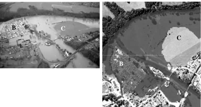
The hydraulic model has been extensively validated by comparisons with observations during recent real flood events. The overall uncertainty of the model has been shown to be lower than 10 cm in terms of free surface elevation.
Figure 1: Comparison of flood extension between a real event (left) and the corresponding simulation (right)
C C A B A B