HAL Id: tel-00955254
https://tel.archives-ouvertes.fr/tel-00955254
Submitted on 4 Mar 2014HAL is a multi-disciplinary open access
archive for the deposit and dissemination of sci-entific research documents, whether they are pub-lished or not. The documents may come from teaching and research institutions in France or abroad, or from public or private research centers.
L’archive ouverte pluridisciplinaire HAL, est destinée au dépôt et à la diffusion de documents scientifiques de niveau recherche, publiés ou non, émanant des établissements d’enseignement et de recherche français ou étrangers, des laboratoires publics ou privés.
Etude de l’influence de l’état de surface sur la qualité de
la mesure de la couleur de l’océan à l’aide d’un
simulateur de mission spatiale
Valérie Billat
To cite this version:
Valérie Billat. Etude de l’influence de l’état de surface sur la qualité de la mesure de la couleur de l’océan à l’aide d’un simulateur de mission spatiale. Océan, Atmosphère. Université ParisDiderot -Paris VII, 1997. Français. �tel-00955254�
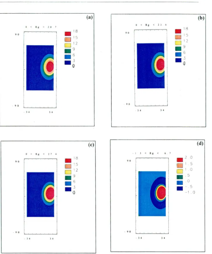
Chapitre 5- Etude de l'influence des incertitudes de modélisation de l'état de surface Partie 2 : analyse des simularions
(a) 0 < Rg < 10 7 9 0 !""' . J 4 J 4 (c) O < Rg <1.7 4 9 0 . 9 0 . J 4 J 4 O < Rg < 2J 6 9 0 . 9 0 . J 4 J 4 - I J < Rg < 6. 7 . 9 0 . J 4 J 4 . 2 0 [ ] 1 5
0
1o
.
• .5
0·
-1 .··
.5
0 (b) (d)Figure 5. 2-1 : Réjlectance spéculaire (en %) pour une demi-orbite du capteur ji;JERJS pour le jour 80 et une vitesse de vent de 5 m.s·'. On a simulé comme variance du modèle de Cox et
Munk (a) une variance maximum,
(b
)
une variance moyenne, (c) une variance minimum. On areprésenté en (d) la différence de réjlectance entre les cas à variance maximum (a) et
minimum (c).
Annexe C -An assessment of veering winds effects on scatterometry from se a surface
Veering wind effects on scatterometry from the sea surface 901
hardware costs and reliabi1ity ought to be eva1uated for a selection of microwave frequencies for satellite systems. Fortunately if the veering angle is less than about ±20°, the errors due to veering winds should be within typical design specifications (± 10 per cent for magnitude, ±20° for direction). If on the other hand
± 20° < Q < ± 55°, the effects of veering winds are dramatic and not negligible so
there is more uncertainty in deriving the stress. The general trends appear regardless of long wave steepness or wind speed, so when weather patterns cause a shift in wind direction grea ter than about ± 20° (on a time scale that is short compared to the long wave relaxation time), results from standard scatterometer data reduction algorithms should be used with prudence.
These findings are dependent upon model assumptions, as is always the case for numerical experiments. Although we used sea surface models that are in accord with present qualitative descriptions, more detailed measurements of sea surface mor-phology for veering winds would certainly be helpful to guide and validate further numerical model development. Refinement of scattering calculations and data
inversion techniques will be dependent upon a better understanding of (a) air-sea
coupling processes, (b) long-wave slope probability density distributions, and (c)
wave-wave interaction mechanisms. In this vein, a recent study by Geernaert et al. (1993) presents progress toward understanding the directional attributes of the ocean surface wind stress vector because it provices in situ measurements which are evidence that the stress vector direction is altered (stress vector and wind vector are non-aligned) due to long-wave effects pursuant to veering winds. The role of various physical mechanisms that might contribute to this deviation is, however, still unsettled; so further research is needed to model momentum flux at the air-sea
interface with respect to the wind profile and sea surface characteristics. It is
suggested that veering wind studies also include microwave scattering measurements so that weather fronts can be accurately monitored globally.
A quality control procedure developed by Stoffelen and Anderson (1993) is being used to validate ERS-1 scatterometer data. The analysis quantifies the coherence of
a0
triplets and the three-term transfer function for CMOD4. Their recent findings show that the data are generally consistent with the CMOD4 wind retrieval algorithm. Over distances of 100-150 km near lows, fronts and tropical cyclones, however, the data frequently do not follow the general distribution of triplets. In these cases, no wind retrieval is attempted. Th us the quality of reported winds is not compromised, but there are occasional gaps. Further study is needed to formulate and validate algorithms suitable for measuring winds near lows, fronts and tropical cyclones. This simulation indicates that directional properties of large waves need to be included in those investigations.
Acknowledgrnents
Parts of the scattering model were developed at UCL under contracts with the European Space Agency (ESA), whose financial support is acknowledged. Financial support was also provided by the NASA Mission to Planet Earth Program; the Office of Naval Research, Marine Boundary Layer Advanced Research Initiative of the Remote Sensing Program and the Physical Oceanography Program; and the Centre National de la Recherche Scientifique. Claude Klapisz of DEA de Methode physique en télédetection, L'Université de Paris VII helped to coordinate and
support this collaboration with V. Billat.
Annexe C -An assessment of veering winds effects on scatterometry from se a surface
Veering wind effects on scatterometry from the sea surface 903
cross section used to derive SEASAT A satellite scatterometer winds. Journal of
Geophysical Research, 87, 3318-3336.
SOBIESKI, P. C., GUISSARD, A., BAUFAYS, C., VAN HoENACKER, D., GUILLAUME, A. M., and
VAN DER VoRST, A., 1986, Study on propagation and inverse scattering, ESA Report 5285/82, ESTEC, The Netherlands, 5 volumes.
SOBIESKI, P.C., GuiSSARD, A., and BAUFAYS, C., 1991, Synergie inversion technique for active
and passive microwave remote sensing of the ocean. I.E.E.E. Transactions on
Geo-science and Remote Sensing, 29, 391-406.
SOBIESKI, P. C., GurssARP, A., BAUFAYS, C., and SIRAUT, P., 1993, Sea surface scattering
calculations in maritime satellite communications. I.E.E.E. Transactions on
Communi-cations, 41, 1525-1533.
SOBIESKI, P. C., GurssARD, A., and BAUFAYS, C., 1994, Comparison of microwave signatures
for fully and nonfully developed sea models. Remote Sensing of the Environment, 48,
39-50.
STOFFELEN, A., and ANDERSON, D. L. T., 1993, ERS-1 scatterometer data characteristics and
wind retrieval skill. Proceedings of first ERS-1 Symposium-S pace at the Service of our
Environment, Cannes, France, 4-6 November 1992. In ESA Sp-359, (Noordwijk, The
Netherlands: ESTEC), pp. 41-47.
ToBA, Y., 1973, Local balance in the air sea boundary processes. Part III: On the spectrum of
wind waves. Journal of the Oceanic Society of lapan, 29, 209-220.
ULABY, F. T., MooRE, K. M., and FUNG, A., 1982, Microwave remote sensing, II (Reading,
MA: Addison Wesley Publishing Company).
VALENZUELA, G. R., 1968, Scattering of electromagnetic waves from a tilted slightly-rough
surface. Radio Science, 3, 1057-1066.
VAN VLEDDER, G. P., and HoLTHUIJSEN, L. H., 1993, The directional response of ocean waves
to tuming winds. Journal of Physical Oceanography, 23, 177-192.
WOICESHYN, P. M., WuRTELE, M. G., Booos, D. H., McGoLDRICK, L. F., and PEREHERYCH,
S., 1986, The necessity for a new parameterization of an empirical mode! for wind/
ocean scatterometry. Journal of Geophysical Research, 91, 2273-2288.
YoUNG, 1. R., HASSELMANN, S., and HASSELMANN, K., 1987, Computations of the response of
a wave spectrum to a sudden change in wind direction. Journal of Physical
Oceanogra-phy, 17, 1317-1338.
RESUME
Nous présentons un outil logiciel qui permet de simuler une mission spatiale dans son intégralité. Ceci constitue une approche nouvelle en télédétection. Les concepteurs de missions et les scientifiques peuvent ainsi mieux appréhender la complexité toujours croissante des futures missi()ns. Ce simulateur permet, bien avant le lancement de la mission, de considérer l'ensemble dit système, qui comprend évidemment le capteur, mais aussi les caractéristiques de l'orbite de la plate-forme qui l'emportera, ainsi que les algorithmes de traitement des données qui seront effectués au sol. Ce simulateur apporte une aide précieuse dans le cadre du dimensionnement et de l'analyse d'une mission spatiale ; il permet de comprendre comment la performance de tout ou partie du système contribue à la performance globale de la mission. La mission spatiale simulée dans le cadre de cette thèse est la mission du capteur MERlS (Medium Resolution Imaging Spectrometer) de l'Agence Spatiale Européenne, dont l'objectif principal est la mesure de la couleur de l'eau.
Nous utilisons le simulateur pour évaluer la dynamique du signal en entrée du capteur, pour calculer la résolution radiométrique nécessaire au capteur pour satisfaire les objectifs de la mission et pour étudier la sensibilité du signal à de petites variations en attitude de la plate-forme. Nous étudions ensuite l'influence de la qualité de la modélisation de l'état de la surface océanique sur la qualité de la mesure de la couleur de l'eau. Nous montrons que les incertitudes, liées
à
une modélisation trop imprécise des effets de surface età
une méconnaissance de la vitesse du vent, induisent des erreurs sur le signal marin pouvant être supérieuresà
la précision attendue par la mission.Mots
clés : télédétection, simulation de mission spatiale, MERlS, couleur de l'eau, effets de surface, océan.ABSTRACT
W e present a software tool that allows to perform end-to-end simulations of a space mission, which is a quite new approach in remote sensing. It addresses the need of engineers and scientists to better understand the new missions whose complexity is increasing. This end-to-end simulation tool allows far before the launch to assess the performance of the overall system including the instrument, the satellite platform and the ground processing algorithms. It is of great help in the frame of space mission design and analysis and helps understanding how the performance of ail or part of the system contributes to the mission performance. The space mission simulated in this work is that of the Medium Resolution Imaging Spectrometer (MERlS) developed by the Space European Agency whose main objective is the remote sensing of ocean colour.
We use the simulator to evaluate the signal dynamics at sensor entrance, to compute the sensor radiometrie resolution needed to satisfy the mission objectives and to study the signal sensitivity to small variations in platform attitude. Then we study the influence of the quality of the modelling of the reflection effects at the sea surface upon the ocean colour retrieval. We show that the uncertainties, due to a lack of precision in modelling of surface effects and to the uncertainty in the wind speed induce errors on the marine signal that can be greater than the mission expected accuracy.
Key words: remote sensing, space mission simulation, MERlS, ocean colour, sea surface effects, ocean.