Science Arts & Métiers (SAM)
is an open access repository that collects the work of Arts et Métiers Institute of
Technology researchers and makes it freely available over the web where possible.
This is an author-deposited version published in:
https://sam.ensam.eu
Handle ID: .
http://hdl.handle.net/10985/9838
To cite this version :
Nouha HICHRI, Chiara STEFANI, Livio DE LUCA, Philippe VERON - Review of the “ as-buit BIM ”
approaches - In: 3D-ARCH International Conference, Italie, 2013 - Proceedings of the 3D-ARCH
International Conference - 2013
Any correspondence concerning this service should be sent to the repository
Administrator :
archiveouverte@ensam.eu
REVIEW OF THE « AS-BUILT BIM » APPROACHES
N. Hichri a,b, C. Stefani b, L. De Luca b, P. Veron a
a
UMR CNRS LSIS 7296, Ecole Nationale Supérieure d’Arts et Métiers ParisTech, 2 Cours des Arts et Métiers 13617 Aix-en-Provence – France – (nouha.hichri, philippe.veron)@ensam.eu
b UMR (CNRS/MCC) MAP-Gamsau 3495, Ecole Nationale Supérieure d’Architecture de Marseille, 184 Avenue
de Luminy 13009 Marseille – France – (chiara.stefani, livio.deluca)@map.archi.fr
KEY WORDS: Point clouds, Building Information Modeling, as-built BIM, object recognition, geometric modeling, historical building
ABTRACT:
Today, we need 3D models of heritage buildings in order to handle more efficiently projects of restoration, documentation and maintenance. In this context, developing a performing approach, based on a first phase of building survey, is a necessary step in order to build a semantically enriched digital model. For this purpose, the Building Information Modeling is an efficient tool for storing and exchanging knowledge about buildings. In order to create such a model, there are three fundamental steps: acquisition, segmentation and modeling. For these reasons, it is essential to understand and analyze this entire chain that leads to a well- structured and enriched 3D digital model. This paper proposes a survey and an analysis of the existing approaches on these topics and tries to define a new approach of semantic structuring taking into account the complexity of this chain.
1 INTRODUCTION
Nowadays, there is an urgent need to get fast and efficient ways to shift from raw 3D data acquisition to a complete and semantically enriched CAD building model. Specifically, since few years, the concept of Building Information Modeling (BIM) is more and more in expansion and democratization among professionals of architecture and civil engineering. This concept belonging to the digital mock-up and to the field of AED (Architecture, Engineering, and Design), reveals an essential tool for the semantization of 3D models. It is based on a set of structured architectural information on buildings, concerning components, characteristics and relations between them. As matter of example, the composition of a door or the location of an object in a room, are features described by BIM: they allow both complementing and enriching the purely geometric information of a digital mock-up by associating semantic descriptions.
At the same time, also in the domain of heritage building, manipulating structured 3D models is an increasing need in order to handle conservation, restoration, modification or reconstruction projects and to support their management (such as organization of exhibitions, tours, various events, etc.). Moreover, in order to acquire accurate data on existing buildings, various techniques are adopted: among them laser scanner which permits to obtain a point cloud of the building. The main interest of this architectural survey technique lies in the acquisition speed ensuring a precise representation of its physical characteristics with minimal errors.
1.1 Fundamental problem
Even if some architectural software companies (such as Autodesk Revit) are proposing new tools for exporting point clouds, in architecture there is no software ensuring a direct shift from point clouds to complete CAD models. The specificity of architectural components makes this task more difficult than in the field of mechanics. In fact, any dedicated software can handle heavy point clouds issued from laser scanning and structure or segment them. However, this task is not sufficient to build an efficient digital representation of buildings. For that, it is essential to analyze and understand the entire chain that goes from the point cloud to the structured enriched 3D model. This process should take into account three main steps: the acquisition, the segmentation, and the enriched 3D modeling (BIM).
1.2 Aim and structure
This paper proposes a review of the existing approaches on the three main topics mentioned below. In section two, a quick review of the techniques of 3D acquisition is drawn. Then, in section three, a brief presentation of some point cloud segmentation approaches is proposed. Section four, describes an overview of “as-built” approaches of characterization classifying methods of components representation according to shapes, relations, and attributes. This classification is followed by a review of various “as-built” BIM approaches. Then, a critical analysis for these approaches will be accomplished before introducing the conclusion.
2 OVERVIEW OF DATA ACQUISITION APPROACHES
The main techniques of acquisition and data collection are topometry, photogrammetry and lasergrammetry. Topometry includes all the traditional ways of survey which are based on the use of optical telescopic sightand a measuring system for angular direction of sight. It permits a high precision but requires an important quantity of work in order to find significant structures of the object to facilitate its post-treatment. This becomes more tedious when objects are more complex (Deveau, 2006). This technique is really time-consuming compared to other survey methods.
Photogrammetric techniques are adopted for the 3D restitution of scenes using images taken from different points of view (Guarnieri et al., 2004) (Grussenmeyer et al., 2001). Even if this technique is not the easiest neither the speediest, the resulting point cloud is enriched with color information that could help informing about the conservation material state in the case of historical building. Moreover in some hybrid approach (De Luca, 2006), photos can be manipulated in a second phase and allow completing missing parts of the point cloud. In term of time and speed, the most efficient technique, is the one of scanner laser (Fuchs et al., 2004). It is a real-time and direct acquisition solution proceeding by projecting a laser beam onto the surface to be measured (Boehler et al., 2002). There are different kinds of scanner: Long-range scanners measure angles (horizontal and vertical) and distances by calculating the time of flight or by comparing the phase shift of the transmitted and received wave of a modulated signal (Marbs et al., 2001). Triangulation scanners include a base and calculate the impact point of the laser beam using one or two CCD camera (Marbs et al., 2001). Today laser scanning technologies are in constant evolution and allow obtaining a better point clouds quality with highest density of points and a reduced error margin.
The result of those techniques is an unstructured point cloud. Even if some hybrid approaches permit completing the missing parts by combining different survey techniques, there is no current way allowing structuring the cloud in the acquisition phase.
3 OVERVIEW OF POINT CLOUD SEGMENTATION APPROACHES Point cloud segmentation is a huge aspect whose research is in constant progress. It can be manual, automated or semi-automated and leads structuring the point cloud in sub parts and removing the unnecessary data from it. This article will not focus on all those segmentation approaches, but we will list some methods that has been applied to an architectural field in order to facilitate the next step of shape recognition.
Among methods applied in the architectural field, one is based on color similarity and spatial proximities (Zhana et al., 2009): it uses an algorithm based on region growing in order to find the nearest neighbor of each seed point creating regions which will be merged and refined
on the basis of colorimetrical and spatial relations. Others methods are based on shape detection (Ning et al, 2010): In a first step they use an algorithm based on region growing and normal vectors adopted to segment each planar region. Then, architectural components are extracted through an analysis of planar residuals. There are also other methods based on a distance measured between planar faces (Dorninger et al., 2007). This method is inspired from the 2.5D segmentation approach introduced by (Pottman et al., 1999) and it measures the distance in order to determine seed-clusters for which a region growing algorithm is performed. After that, an analysis of component connection is accomplished in the object space in order to merge similar seed-clusters. All previous point cloud segmentation, deal with the architectural field but are limited to surfaces segmentation. In addition, in the field of cultural heritage, studies are almost nonexistent. However, in the field of industry, many researches focused on this issue and presented interesting results (Golovinskiy et al., 2009), (Rabbani et al., 2006).
4 OVERVIEW OF “AS-BUILT” BIM APPROACHES
The BIM is a digital representation for physical and functional characteristics of buildings and constitutes the most efficient representation in order to obtain a semantically enriched model.
When current literature deals with “as-built” BIM, it means that the building is described with a BIM representation concerning the state of the building at the moment of the survey. Thus it informs about the state of conservation of historic building.
“As-built” BIM involves 3 aspects: firstly, the geometrical modeling of the component, then the attribution of categories and material properties to the components and, finally the establishing of relations between them.The process of creation is usually manual. In fact, any software allows including all these tasks and even if reverse-engineering software are very efficient in geometric modeling, semantic information is not completely handled. In addition, BIM design systems cannot manage neither manipulate the huge quantities of information issued from laser scanner and are incapable to directly convert primitives created from reverse-engineering tools.
4.1 “As-built” BIM characterization
“As-built” BIM characterization involves three aspects, allowing building a structured point cloud: shapes, relations and attributes. These aspects will be detailed below.
4.1.1 Representing the shape of the object In the context of “as-built” BIM representing the shape of the object can be classified according to three dimensions: parametric or non-parametric, global or local explicit or implicit. (Tang et al., 2010)
Parametric Vs. non-parametric representation. In the case of a parametric representation (Campbell et al., 2001), the model is described using a set of parameters: height, length, radius, etc. Besides, non-parametric representation uses another ways of characterization. For example, a cylinder is described along its axis and its radius, whereas in non-parametric representation it will be represented using a triangular mesh. (Tang et al., 2010)
Global Vs. local representation
In a global representation, the entire object is described while in a local one only a portion of the object is characterized. For example, parametric representations are mostly considered as a local representation. Also, complex shapes are often considered as local when they are decomposed into parts. In this case, for example CSG is used to represent each part. On the other hand, non-parametric representation, such as triangle meshes, are flexible enough to represent the whole object and can be considered as a global representation.(Tang et al., 2010) Explicit Vs. implicit representation
This is the most significant axis to distinguish the shape of the object. Explicit representation permits direct encoding of the shape of the object (i.e. triangular meshes). Implicit representation allows an indirect encoding for the shape of the object, using an intermediate representation (i.e. a histogram of normal surfaces). Explicit representations can be divided into two categories: surface representation and volumetric representation. Among surface representation, B-Rep describes shapes by a set of surface components constituting usually the limits of surface (Baumgart et al., 1972). Volumetric representations describe shapes with geometric solids known as CSG (Constructive Solid Geometry), which consists on building complex shapes starting from simple geometric primitives (such as cube, cylinder, sphere…) by combining them using Boolean operators like union or intersection. (Chen et al., 1988) The main advantage of CSG is the intuitive handling, but they are not so flexible, because of their very limited library of primitives (Kemper et al. 1987) (Rottensteiner et al., 2000). However B-Rep allows efficient representation of partial objects, such as partially occluded objects, which are very frequent in “as-built” BIM creation (Walker et al., 1989). Even if explicit representation allows a precise description of geometries that are required for modeling the “as-built” BIM, they do not really fit algorithms for recognition and automatic segmentation. For this reason, alternative representations are often used.
4.1.2 Representing relations between objects Representing relations between objects is a fundamental requirement in the case of BIM. In effect, relations are necessary to describe positions, and displacements of components (i.e. diagnosis on lacks and failures in tubes and pipelines, navigation inside a building, etc.) (Nüchter et al., 2008) (Cantzler et al. 2003).
Some proposes detail the different spatial relations in a BIM context: aggregation, topological and directional relationships. Aggregation (i.e. part of, belong to, etc.), could be modeled with a hierarchical-based tree representation that permits to describe the composition in a local-to-global way. For example, nodes could represent objects or primitives and arc could represent the aggregation relations linking them (Fitzgibbon et al., 1997). Topological relationships (i.e. connected to, inside, outside of, over, etc.), and directional relationships (i.e. above, below, etc.), can be represented by a graph-based. However, it is possible to represent all those spatial relationships by using a B-Rep representation. 4.1.3 Representing objects attributes
If relations and shapes are well-described, few studies focus on attributes. The representation of this feature is essential in the context of BIM. In effect, it allows characterizing objects in order to enrich the final 3D representation. They include information about materials, (texture, age, cost, etc.) and can inform also on the state of conservation and on the documentation of historic building, for instance, whether the object has been replaced or restored,
Attributes or object classes can be: graphical or alphanumerical (Solamen, 2009). The graphical attributes includes properties required for the 3D modeling (Cartesian points, numerical values, limited spaces, etc.). The alphanumerical attributes includes all additional information concerning dimension, composition, economic data, etc.
Attributes are also structured on a set of classes (Ben Osman, 2011). In effect, every object is characterized by semantic information defining it. Classes can be tangible (i.e. wall, floor, ceiling, etc.) and abstract (cost, manufacturing process, relationships between classes, etc.)
4.2 Review of “as-built” BIM approaches
The manual process of “as-built” BIM creation is tedious, intensive, subjective, and requires skilled workers. In effect, manual modeling of simple primitives is time-expensive, and modeling a historical building can be very difficult, and may require thousands of primitives. Automating or semi-automating the process can be very challenging for main reasons. First, digital models of buildings can be very complex and contains not linked components. Those kinds of components are known as clutter and cannot figure on the final BIM. Then, input data can be insufficient and resulting data can vary according to modeling details and users expectations. All those difficulties become more important when it comes to historical buildings. In fact, historic buildings are very complex because they are characterized by a huge number of various shapes.
Approaches can be classified into four main categories: heuristic approaches, approaches based on context, approaches based on prior knowledge and approaches based on ontologies.
Heuristic approaches
Studies on this field are at their early stages and most of methods, like heuristic approaches, rely on a first segmentation of the scene. Those approaches use a human knowledge codification that belongs to the architectural field. In effect, some functions are fix. As matter of example, doors and windows are always embedded in wall class, roofs are always “hierarchically above” walls. We can also distinguish walls and roofs according to their directions: in effect walls are always vertical while roofs may have various inclinations. Among these works, an algorithm has been developed and allows extracting windows from building façades (Pu et al., 2007). It is based on three steps: a first step of segmentation using the (Vosselman et al., 2004) method, then a step of constraint definition (position, size, topology, direction, etc.) and finally, a last step of recognition, using a heuristic table. Other algorithms allow the automatic extraction of building features (Pu et al., 2006) and finally the algorithm of (Rusu et al., 2009) uses heuristics to detect elements in a kitchen environment.
Approaches based on context
Following this same heuristically logic, some modeling approaches based on context use relations between components. As a matter of example, (Xiong et al., 2010) uses this approach to model the interior of a room. A first step of voxelization allows encoding input data from point clouds and turns them on a voxel structure to minimize the density of points variations. Then, it detects planar patches by combining neighbor points using a region-growing method. Those patches will then be classified according to their contextual relationships, on patches of wall, ceiling, floor and clutter. For example, in the case of planar patches surrounded by walls, adjacent to the floor in the bottom and to the ceiling on the top, it is more probable to correspond to a wall patch than a clutter one. At least, a last step of patch intersection and removing for clutter is operated.
Approaches based on prior knowledge
Another “as-built” modeling approach is the recognition method based on prior knowledge. This approach follows the principle of detecting differences existing between the conditions of the "as-built" and "as-designed". In this kind of approach, the recognition problem is reduced to a simple problem of fitting or matching between the entities of the scene and the point cloud. This kind of approach is used by (Yue et al., 2006) to detect construction defects in some sites.
Approaches based on ontologies
A last modeling approach is the approach based on ontologies. This method introduced by (Hmida et al., 2012), and which is based on knowledge anthology inspired by the model of the semantic web, uses a priori knowledge of objects and environment. This knowledge is extracted from databases, CAD drawings, GIS, technical reports or expert knowledge belonging to particular fields. Therefore, this knowledge constitutes the basis of a knowledge-based selective detection and recognition of objects in point clouds. In such a scenario,
the knowledge of these objects must include detailed information on the geometry of the object structure, 3D algorithms, etc.
All approaches mentioned previously identify some or all of the characteristic elements of a scene. Their performance and efficiencies are probably related to the complexity of the scene.
4.3 Critic analysis of “as-built” BIM approaches All the approaches mentioned above provide fairly satisfactory results in the case of flat surfaces and simple scenes, which is not the case for modeling heritage buildings. In fact, historic buildings are characterized by very complex and varied shapes, mostly not responding to classical geometrical laws. For example, walls are not always vertical and can be tilted in many cases. Some elements are even more complex such as capitals which have specific characteristics and different architectural styles. Modeling them becomes even harder because of their deterioration over time. In effect, due to degradations, elements having common semantic features lose similarities at the level of their shapes. This is, for instance, the case of capitals with their details (acanthus leaf, volute, etc.). In this context, a study (Murphy M. 2011) tried to create a library of parametric objects based on historic data and called HBIM (Historical Building Information Modeling).
Therefore, in order to semantically enrich point clouds, it is not sufficient to detect their sub-parts as architectural components (walls, windows, doors, etc.). An important requirement is also to define the relations linking components to their attributes, in particular, spatial relations (topological, directional, etc.) between them. As example, if a wall is detected, it should be specified that it is connected to the ground, in a specific position, adjacent to other walls, these last ones having other positions, etc.
Finally, attributes can vary according to the field, to the needs of management and to the use of the building. As consequence, in the field of historical building it could be also necessary to qualify other kinds of attributes such as material, color, conservation state, etc. specifying, for example, whether such wall is made of stone or bricks.
5 CONCLUSION
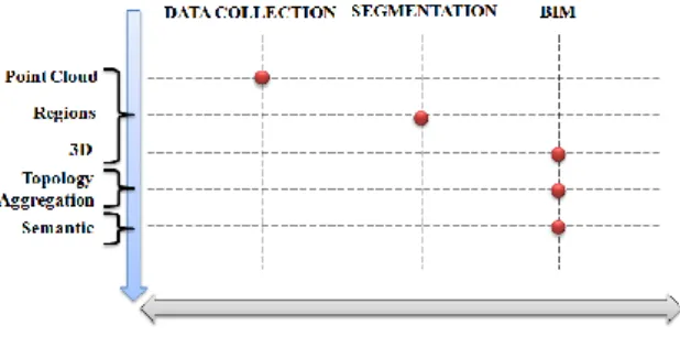
Previous paragraphs illustrated techniques of acquisition, segmentation of point clouds and current methods to semantically enrich data. With the aim of obtaining enriched 3D models, these approaches are complementary and are used in consecutive way: the acquisition step produces not structured point clouds, then they are segmented into regions with several segmentation algorithms, and finally the 3D model is constructed and enriched using different recognition techniques (Figure 1).
Figure 1: Process of BIM creation composed by complementary and consecutive tasks (collection, segmentation, BIM) in order to get point clouds, regions,
3D representation, relations and attributes This panorama of research demonstrated that even if this approach can lead to satisfactory results in the case of modern buildings, in the field of cultural heritage this chain is not well-adapted. For this reason, we propose an approach that starts enriching the 3D model at the early stages of data collection and segmentation (Figure 2)
Figure 2: The proposed approach which suggest enriching the final 3D model at the beginning of the process by defining relations and attributes at the phases
of data collection and segmentation
This approach proposes to link the first step of acquisition and the final “as-built” BIM. Semantic features will be affected to historic objects directly in the survey and the segmentation stages, on the basis IFC classes.
Specifically in the next years, this approach will be implemented by creating a communication platform between common laser scanner software and BIM one (Autodesk Revit and Faro Scene). This communication will be ensured by a common data base following the IFC classification model (Figure 3).
Figure 3: Illustration of the software environment of the approach based on a conceptual communication built
according to an IFC classification model.
6 REFERENCES
Baumgart B, 1972. Winged Edge Polyhedron Representation. Stanford University for Advanced Resarch Projects Agency.
Ben Osman N., 2011. Reconstruction 3D des scenes architecturales par ajustement de primitives paramétrables. Internship Report, Map-Gamsau
Boehler, W., G. Heinz, and A. Marbs. 2002. The potential of non-contact close range laser scanners for cultural heritage recording. In: The International archives
of Photogrammetry, Remote Sensing and Spatial Information Sciences, Vol 34 (5/C7), pp 430–436.
Campbell, R., and. Flynn P. 2001. A Survey Of Free-Form Object Representation and Recognition Techniques. Computer Vision and Image Understanding, Vol 18, pp 166–210.
Cantzler, H., 2003. Improving Architectural 3D
Reconstruction by Constrained Modelling, College of
Science and Engineering. School of Informatics, University of Edinburgh, PhD Edinburgh.
De Luca, L., 2006. Relevé et multi-représentations du
patrimoine architectural Définition d’une approche hybride pour la reconstruction 3D d’édifices. PhD Arts et
Métiers ParisTech.
Deveau, M., 2006. Utilisation conjointe de données
image et laser pour la segmentation et la modélisation 3D. PhD Université René Descartes - Paris 5
Dorninger, P., and C. Nothegger. 2007. 3D segmentation of unstructured point clouds for building modelling.
International Archives of the Photogrammetry, Remote Sensing and Spatial Information Sciences, Vol 35, pp
191–196.
Fitzgibbon, A., Eggert D. and. Fisher, R., 1997, High-level model acquisition from range images,
Computer-Aided Design , Vol 29, pp 321–330.
Fuchs, A., Alby E., Begriche R., Grussenmeyer, P., and Perrin J. P.. 2004. Confrontation du relevé laser 3D aux techniques de relevé conventionnelles et de développement d’outils numériques pour la restitution architecturale. Revue fran\ccaise de photogrammétrie et
de télédétection, Vol (173/174), pp 36–47.
Golovinskiy A., and Funkhouser T., 2009. Min-Cut Based Segmentation of Point Clouds, Computer Vision Workshops (ICCV Workshops), IEEE 12th International Conference, pp 39-46.
Grussenmeyer P., Hanke K., and Streilein A. 2001.
Photogrammétrie numérique, Chapter Photogrammetrie
architecturale. Éditions Lavoisier-Hermès.
Guarnieri A., Remondino F. and Vettore A. Photogrammetry and Ground-based Laser Scanning: Assessment of Metric Accuracy of the 3D Model of Pozzoveggiani Church. FIG Working Week 2004. TS on “Positioning and Measurement Technologies and
Practices I- Laser Scanning and Photogrammetry”. Athens, Greece.
Hmida, H., Cruz C., Boochs F., and Nicolle C., 2012. From Unstructured 3D Point Clouds to Structured Knowledge-A Semantics Approach. Semantics-Advances In Theories and Mathematical Models, p 213.
Kemper A, and Wallrath, M., 1987, An analysis of geometric modeling in database systems, ACM Computing Surveys. Vol 19, pp 47–91.
Lin, W., and Chen, T., 1988 CSG-based object recognition using range images, Proceedings of the
International Conference on Pattern Recognition (ICPR),
pp. 99–103.
Marbs A., Heinz G., and Boehler W., 2001. The potential of non-contact close range laser scanners for cultural heritage recording. Proceedings of CIPA
International Symposium. Potsdam, Germany.
Murphy, M., McGovern, E., and Pavia, S., 2011. Historic Building Information Modeling - Adding Intelligence to Laser and Image based Surveys. Proceeding of the 4th
ISPRS International Workshop. Vol 38, p 5
Nguyen T-H,. Oloufa A-A, and Nassar K, 2005 Algorithms for automated deduction of topological information, Automation in Construction, Vol 14 pp 59– 70.
Ning X, Zhang X, Wang Y and Jaeger M, 2010 Segmentation of architecture shape information from 3D point cloud
Nüchter A, J. Hertzberg, 2008. Towards semantic maps for mobile robots, Journal of Robotics and Autonomous
Systems (RAS), Vol 56, pp 915–926.
Pottmann, H., Wallner, J., 1999. Approximation algorithms for developable surfaces. Computer Aided
Geometric Design, Vol 16, pp. 539-556.
Pu, S., and Vosselman.G, 2006. Automatic extraction of building features from terrestrial laser scanning. International. Archives of Photogrammetry, Remote
Sensing and Spatial Information Sciences, Vol 36, pp 25–
27.
Pu. S and Vosselman G. 2007. Extracting windows from terrestrial laser scanning. In ISPRS Workshop on Laser
Scanning, pp 320:325.
Rabbani, T., Van den Heuvel, F.A. and Vosselman, G. 2006.International Archives of Photogrammetry, Remote Sensing and Spatial Information Sciences. Vol 36, pp
248-253.
Rottensteiner F, 2000 Semi-automatic building reconstruction integrated in strict bundle block adjustment, IAPRS 2000, Amsterdam.
Rusu R, Marton Z, Blodow N, Holzbach A and Beetz M, 2009. Model-based and learned semantic object labeling in 3D point cloud maps of kitchen environments,
IEEE/RS. International Conference on Intelligent Robots and Systems, IROS.
Solamen, 2009 Analyse BIM IFC
Tang, P, Huber D, Akinci B, Lipman R, and Lytle A. 2010. Automatic reconstruction of as-built building information models from laser-scanned point clouds: A review of related techniques. Automation in Construction Vol 19, pp 829–843.
Walker E.G.L, 1989. Frame-based geometric reasoning
for construction and maintenance of 3D world models,
School of Computer Science. PhD Pittsburgh - Carnegie Mellon University, p. 145.
Xiong, Xuehan, and Daniel Huber. 2010. Using Context to Create Semantic 3D Models of Indoor Environments . British Machine Vision Association.
Yue, K., D. Huber, B. Akinci, and R. Krishnamurti. 2006. The ASDMCon project: The challenge of detecting defects on construction sites. In 3D Data Processing,
Visualization, and Transmission, Third International
Symposium on, pp 1048–1055.
Zhana, Q., Y. Liangb, and Y. Xiaoa. 2009. Color-based segmentation of point clouds . IAPRS Vol XXXVIII, Part 3/W8.