Validation of ground penetrating radar full-waveform
inversion for field scale soil moisture mapping
Julien Minet
∗1, Patrick Bogaert
1, Marnik Vanclooster
1, and S´ebastien Lambot
1,2 1Earth and Life Institute, Universit´e catholique de Louvain, Croix du Sud 2 BP 2,
B-1348 Louvain-la-Neuve, Belgium
2
Agrosphere (IBG-3), Institute of Bio- and Geosciences, Forschungszentrum J¨ulich
GmbH, D-52425 J¨ulich, Germany
February 22, 2011
Abstract
Ground penetrating radar (GPR) is an efficient method for soil moisture mapping at the field scale, bridging the scale gap between small-scale invasive sensors and large-scale remote sensing instruments. Nevertheless, commonly-used GPR approaches for soil moisture characterization suffer from several limitations and the determination of the uncertain-ties in GPR soil moisture sensing has been poorly addressed. Herein, we used an advanced proximal GPR method based on full-waveform inversion of ultra-wideband radar data for mapping soil mois-ture and uncertainties in the soil moismois-ture maps were evaluated by three different methods. First, GPR-derived soil moisture uncertainties were computed from the GPR data inversion, according to measure-ments and modeling errors and to the sensitivity of the electromagnetic model to soil moisture. Sec-ond, the reproducibility of the soil moisture map-ping was evaluated. Third, GPR-derived soil mois-ture was compared with ground-truth measurements (soil core sampling). The proposed GPR method ap-peared to be highly precise and accurate, with spa-tially averaged GPR inversion uncertainty of 0.0039 m3m−3, a repetition uncertainty of 0.0169 m3m−3
and an uncertainty of 0.0233 m3m−3 when
com-pared with ground-truth measurements. These un-certainties were mapped and appeared to be related to some local model inadequacies and to small-scale variability of soil moisture. In a soil moisture map-ping framework, the interpolation was found to be the determinant source of the observed uncertain-ties. The proposed GPR method was proven to be largely reliable in terms of accuracy and precision and appeared to be highly efficient for soil moisture
mapping at the field scale.
1
Introduction
The importance of accurate soil moisture character-ization at various temporal and spatial scales for hy-drologic, climatic and agriculture applications has boosted the development of different soil moisture sensing techniques. Review of soil moisture mea-surements techniques, including descriptions of the sensors, applications and research outlooks are given by Robinson et al. (2008a,b) and Vereecken et al. (2008). A particular development of remote sensing of soil moisture technologies was observed in the re-cent years (Wagner et al., 2007). At a much smaller support scale, invasive sensors such as time domain reflectometry (TDR) and capacitance probes are re-vealing their best potentialities in recently deployed wireless sensors networks (Bogena et al., 2010) that allow to collect huge amount of soil moisture data with an unprecedented temporal resolution. Never-theless, the small sampling volume of these inva-sive sensors (∼ dm) can be hardly compared with the larger footprint of the remote sensing instrument, even for high-resolution active radar sensors (∼ 10 m), given the inherent high spatial variability of soil moisture at the radar footprint scale.
With an intermediate support scale (∼ m), ground penetrating radar (GPR) for soil moisture sensing may bridge the scale gap between invasive sensors and remote sensing instruments. A review about re-cent GPR developments can be found in Slob et al. (2010) while a complete review of GPR applica-tions for soil moisture sensing was given in Huis-man et al. (2003). Numerous studies used the now well-established GPR ground-wave techniques for soil moisture determination (e.g., Huisman et al.,
2002; Grote et al., 2003; Galagedara et al., 2005; Lunt et al., 2005; Grote et al., 2010). Recently, some authors proposed innovative soil moisture re-trieval techniques using the same GPR sensors. In that respect, van der Kruk (2006) and van der Kruk et al. (2010) developed an inversion method of dis-persed waveforms trapped in a surface waveguide (i.e., when soil is layered by freezing, thawing or by a wetting front) for retrieving its dielectric permittiv-ity and thickness. Benedetto (2010) used a Rayleigh scattering based method for directly determining the soil moisture, without the need of a petrophysical re-lationship and calibration of the GPR system.
Off-ground (i.e., proximal or air-launched) GPR systems offer particularly promising perspectives in terms of proximal soil sensing, as antennas can be rapidly moved over the soil surface when mounted on mobile platforms. Using an approach similar to satellite remote sensing of soil moisture, the retrieval of soil moisture using off-ground GPR is based on the measurement of the soil surface reflection. Few studies have applied such an off-ground GPR ap-proach for soil moisture sensing in field conditions (Chanzy et al., 1996; Redman et al., 2002; Serbin and Or, 2003, 2005). Based on a full-waveform in-version of the GPR data and an accurate GPR system modeling, the off-ground GPR system developed by Lambot et al. (2004, 2006b) has shown excellent potentialities for surface soil moisture sensing and mapping in field conditions (Weiherm¨uller et al., 2007; Lambot et al., 2008; Jadoon et al., 2010a; Jonard et al., 2010; Minet et al., 2011). The method relies on an accurate radar model that, in particular, accounts for the antenna and antenna-soils interac-tions.
The validation of the GPR technology for soil moisture retrieval implies a comprehensive assess-ment of the uncertainties in retrieval methods. The methods for assessing the uncertainties vary greatly in the literature, furthermore depending on the GPR system. Most of the studies attempted to calibrate or validate GPR measurements by comparing the GPR estimates with another measurement technique as-sumed to be the ground-truth (mainly TDR or soil sampling). Using the ground-wave technique, Huis-man et al. (2001) compared GPR and TDR esti-mates of soil moisture with gravimetric sampling measurements and found similar root mean square error (RMSE) around 0.03 m3m−3. The sources of errors were also identified and the dominant er-ror was attributed to the petrophysical relationship. In controlled laboratory conditions, Lambot et al. (2004) found a very low RMSE of 0.0066 m3m−3
between water content from sampling measurements and off-ground GPR using a linear approximation of the frequency-dependent effective electrical
conduc-tivity. However, in field conditions and using the same off-ground GPR, Jadoon et al. (2010a) found a RMSE of 0.025 m3m−3between TDR and GPR
es-timates. The errors were mainly attributed to the dif-ferent support scales of the instruments with respect to the small-scale within-field variability. As well as for remote sensing, the different support scales and the large vertical and lateral variations of soil mois-ture in real conditions may actually preclude the use of small-scale ground-truthing to fully validate the GPR sensors for soil moisture.
In that respect, Jacob and Hermance (2004) as-sessed the reproducibility of GPR common mid-point (CMP) measurements using information from the same CMP measurements and from several inde-pendent CMP measurements performed at the same location. Using a cross-borehole GPR, Alumbaugh et al. (2002) obtained a RMSE in volumetric soil moisture of 0.005 m3m−3 between repeated
mea-surements. Recently, Bikowski et al. (2010) and Minet et al. (2010b) assessed the posterior distribu-tions of GPR-derived soil properties by a Markov Chain Monte Carlo technique in GPR inversion frameworks. This permitted to quantify confidence intervals around the inverted parameters by account-ing for errors associated with the GPR data process-ing.
In this study, we propose to comprehensively eval-uate the reliability of the GPR system developed by Lambot et al. (2004) for soil moisture mapping in field conditions and to quantify the soil moisture un-certainties. A mobile proximal GPR was used over a 2.5 ha agricultural field to map the soil moisture at high spatial resolution. We evaluated the relia-bility of the GPR technique by three independent uncertainty assessment methods. First, soil mois-ture uncertainties were derived from the inversion of the GPR data for each point by the computa-tion of modeling error and soil moisture sensitiv-ity. Second, three repetitions of the acquisition were performed, in order to assess the reproducibility of the technique, by comparison with the spatial in-terpolation uncertainties. Third, soil moisture core sampling were performed in order to compare the GPR estimates with reference soil moisture mea-surements, allowing for the evaluation of the petro-physical model. These three independent soil mois-ture uncertainty assessment methods were compared and the different sources of errors were identified.
2
Materials and Methods
2.1
Study site
We surveyed a 2.5-ha agricultural field situated in the loess belt area in the center of Belgium (Long.
Elevation [m a.s.l.] 144 m 130 m Soil sampling GPR acquisition 0 25 50 75 100 Meters xx
Figure 1: Study site for the GPR acquisition that was performed along 12 parallel lines. Soil core sampling was performed in 20 locations.
4◦41’8”E, Lat. 50◦35’59”N) (Fig. 1). The soil type is uniformly a silt loam and elevation ranges from 130 to 144 m a.s.l. According to the national Bel-gian soil database (Aardewerk, Van Orshoven and Vandenbroucke (1993)), particles fraction are 4 % of sand, 82 % of silt and 14 % of clay for a soil sampling point situated at 500 m from the field. The GPR acquisition took place at the end of the winter on the 18thof March 2010 in moderately wet
con-ditions. According to a rain gauge station situated 2 km apart from the field, no rainfall were recorded for 11 days, but evaporation was limited due to low tem-peratures (3◦C on average for the 11 previous days). The field was covered by low-grown winter wheat (canopy height lesser than 5 cm). Surface roughness was low (amplitude around 5 cm) as the field was finely ploughed for wheat sowing four months be-fore the campaign while rainfalls have flattened the soil surface during the winter.
2.2
Soil moisture sensing by GPR
2.2.1 GPR setup
The GPR principle for soil moisture sensing is based on the propagation of an electromagnetic wave, which is governed, for non-magnetic soils, by the soil dielectric permittivity ε and electrical conduc-tivity σ. As the relative dielectric permitconduc-tivity of
wa-ter (εw≈ 80) is much larger than the one of the soil
particles (εs ≈ 5) and air (εa = 1), GPR is mainly
sensitive to soil moisture.
The GPR system we used was set up with a vector network analyzer (VNA) (ZVL, Rohde and Schwarz, M¨unich, Germany) connected to an ultra-wideband monostatic horn antenna (BBHA 9120 F, Schwarzbeck Mess-Elektronik, Sch¨onau, Ger-many) situated off the ground. According to the operating bandwidth of the antenna, the VNA em-ulated a stepped-frequency electromagnetic wave from 200 to 2000 MHz, with a frequency step of 6 MHz. For this off-ground configuration, antenna and soil-antenna interactions effects are modeled us-ing frequency-dependent transfer functions for a far-field antenna configuration (Lambot et al., 2006a; Jadoon et al., 2010b).
For field acquisition, we used an all-terrain ve-hicle (ATV) holding the GPR system, a differential global positioning system (DGPS) (Leica GPS1200, Leica Geosystems) and a PC. The PC automatically integrates the DGPS position, launches GPR mea-surements and saves all the measured data. Real-time GPR measurements were performed at a regu-lar spacing of two meters along the same track, ac-cording to DGPS measurements, which are known with a horizontal precision of about 3 cm. The ATV followed 12 parallel tracks with a spacing of 5 m
between the acquisition tracks (see Fig. 1) and a driving speed of about 5 km/h. The GPR antenna footprint where soil moisture is measured has a di-ameter of about 1.5 m and a sampling depth around 5 cm. Three repetitions of the acquisition were per-formed within 3h, accounting in total for 4600 mea-sured points. The purpose of the repetitions were to evaluate the reproducibility of the overall GPR tech-nique in field conditions, including the interpolation effect, knowing that the measured points were not taken exactly at the same locations for each repeti-tion but at least were along the same tracks.
2.2.2 GPR data inversions for surface soil mois-ture
Surface soil moisture was retrieved using full-waveform inversion of GPR data focused on the sur-face reflection. The raw measured GPR data in the frequency domain were first filtered out from the antenna effects using the antenna transfer functions in order to obtain the GPR response from the soil only, as presented in Fig. 2 for an arbitrary GPR measurement. The GPR wave propagation into the soil was modeled using an exact solution of the 3D Maxwell’s equations for waves propagating in a pla-nar layered medium, namely, the Green’s function, which simulates the response of the soil illuminated by the GPR antenna, depending on the soil electro-magnetic properties. In this study, the soil is con-sidered as a homogeneous medium within the GPR antenna footprint. The reader is referred to Lambot et al. (2004) for a complete explanation of the elec-tromagnetic model.
The frequency-dependent GPR data from field measurements were selected from 200 to 800 MHz as the highest frequencies were affected by measure-ments noise arising because of soil roughness scat-tering (Lambot et al., 2006a) (see Fig. 2 (a)). In order to identify the shallow surface soil dielectric permittivity, the GPR data were selected on a time window focused on the soil surface reflection peak, after transformation of GPR data from the frequency to the time domain using the inverse Fourier trans-form. The soil surface reflection peak can be easily detected as it corresponds to the largest oscillation in the time domain GPR waveform, as delineated in Fig. 2 (b). This time-windowing permitted to iden-tify the surface soil dielectric permittivity and corre-lated soil moisture from the shallow soil layer (Lam-bot et al., 2006b; Minet et al., 2011).
Two parameters were optimized in the GPR inver-sion, namely, the surface soil dielectric permittivity
ε and the GPR antenna height h0. The inverse
prob-lem was formulated in the least-squares sense and
the objective function was accordingly defined as:
ϕ(b) =
√
e(b)Te(b)
n− p (1)
with n being the length of the time domain vector,
p the number of parameters, and the error function
e(b) defined as the difference between the measured
and modeled Green’s functions in the time domain with:
e(b) = g↑∗xx(t)− g↑xx(b, t) (2) where gxx↑∗(t) and g↑xx(b, t) being, respectively, the
measured and modeled Green’s functions in the time domain (n × 1) focused on the surface reflection, and b (p× 1) the parameter vector of the inverse problems (b = [ε, h0]).
The inverse problem thus consists of finding the minimum of this objective function by optimizing the parameter values. Optimization was performed using a local search algorithm (i.e., the Levenberg-Marquardt algorithm (Levenberg-Marquardt, 1963)). The ini-tial guess for the dielectric permittivity was arbitrar-ily chosen as ε = 10 as this was a mean expected value for this parameter (corresponding to a volu-metric soil moisture θ ≈ 0.20 m3m−3). The initial guess for the GPR antenna height h0was computed
for each measured Green’s function gxx↑∗(t) in the
time domain using the arrival time of the soil sur-face reflection peak.
For electrical conductivity lower than 0.01 S/m, Lambot et al. (2006b) demonstrated that the electro-magnetic model was insensitive to the electrical con-ductivity in a similar frequency range. Therefore, this parameter could be neglected in the optimization and was set to zero in the electromagnetic model. This assumption was nevertheless verified by per-forming inversions accounting for the optimization of the electrical conductivity, i.e., with b = [ε, h0, σ]
2.2.3 Petrophysical relationships
We used two petrophysical models for relating GPR-derived dielectric permittivity ε to volumetric soil moisture values θ. The first model was the widely-used relationship of Topp et al. (1980) with the clas-sical parameterisation:
θ =−5.3×10⁻²+2.92×10⁻²ε−5.5×10⁻⁴ε2+4.3×10⁻⁶ε3
(3) The Topp’s relationship was used to translate the permittivity retrieved by the GPR data inversions into soil moisture. However, the second model, i.e., the model of Ledieu et al. (1986), was used for fitting the GPR-derived permittivity and volumet-ric soil moisture from soil sampling measurements with:
0.5 1 1.5 2 0 100 200 800 MHz f [GHz] |g -| [−]xx 0.5 1 1.5 2 −2 0 2 800 MHz f [GHz] Ð g - [rad]xx 5 10 15 20 −1.5 −1 −0.5 0 0.5 1 1.5 t [ns] g - xx ( t) Measured Modeled (a) (b)
Figure 2: Measured and modeled Green’s function depicted in the frequency domain in amplitude and phase (a) and in time domain (b). The time-window corresponding to the surface reflection is delineated in (b).
θ = a√ε + b (4)
where a and b are regression coefficients. This model assumes a linear relationship between √ε
and θ and appeared to be more robust for fitting the petrophysical relationship over a limited range of soil moisture conditions in this study. It is also worth mentioning that this model is a simplification of physically-based volumetric mixing models (i.e., the complex refractive index model (CRIM) (Bir-chak et al., 1974; Dobson et al., 1985)).
2.2.4 Soil moisture interpolation
Soil moisture maps were produced by the interpola-tion of point measurements using ordinary kriging. To deal with the uneven disposition of the points in space (i.e., globally a 2 m spacing along the ac-quisition line and a 5 m spacing between lines), a rectangular neighborhood window was chosen such that the same numbers of points were taken in the perpendicular and parallel direction with respect to the acquisition lines direction. Unidirectional vari-ograms were computed and modeled along the ac-quisition lines using an exponential model account-ing for a nugget effect. Interpolated soil moisture values were computed as linear combinations of the values of neighboring points according to the ordi-nary kriging method.
2.3
Uncertainties assessment
Each of the previously exposed steps (i.e., GPR mea-surements, inversions and interpolation) introduces uncertainties in the final soil moisture maps. In this study, we assess the soil moisture uncertainties by three independent ways:
1. by computing GPR inversion uncertainties ac-cording to the modeling error and the model sensitivity to soil moisture;
2. by repeating the acquisition for assessing the reproducibility of the sensing and mapping of soil moisture;
3. by comparing with ground-truth measurements of soil moisture (soil core sampling).
2.3.1 Inversion uncertainties
The GPR data inversion consists in finding the opti-mal set of parameter values that minimizes the ob-jective function (Eq. (1)). The uncertainties of in-verted parameters can be quantified from the value of the objective function at its minimum (modeling error) and from its curvature around the minimum (model sensitivity), accounting for GPR measure-ment and modeling errors. According to Kool and Parker (1988), inverted dielectric permittivity uncer-tainty σε,GP R were determined by the square root
of the diagonal element of the parameter variance-covariance matrix C (p × p) corresponding to the dielectric permittivity:
σε,GP R=
√
Cε (5)
with the matrix C being given by:
C = e
∗Te∗
n− p(J
TJ)−1 (6)
where J is the Jacobian (or sensitivity) matrix (n× p) and e∗= e(b∗), the error vector at the minimum of the objective function (see Eq. (2)). The elements (i,j) of the Jacobian matrix are the partial derivatives
of the error function e(b) with respect to the opti-mized parameters values b∗with:
Ji,j =
δei
δb∗i (7)
The Jacobian matrix thus reflects the way the model is sensitive to a small parameter change. In prac-tice, the partial derivatives δei
δb∗i of the Jacobian
ma-trix were approximated by finite differences, assum-ing a change in the parameter value of 1 %. The un-certainty in dielectric permittivity σε,GP Rwas
trans-lated in uncertainty in soil moisture σθ,GP R using
propagation of error theory:
σθ,GP R=
δθ(ε)
δε σε,GP R (8)
where θ(ε) is the relationship of Topp et al. (1980) (Eq.(3)).
The parameter uncertainty can be seen as the com-bination of two contributions, that are the modeling error and the parameter insensitivity. The modeling error (or error of fit) is the value of the objective function at its minimum, i.e., the value of the objec-tive function for the optimized parameters (ϕ(b∗)). The parameter sensitivity is related to the Jacobian matrix, as it expresses the curvature of the objective function in the vicinity of the minimum for a small change in the optimized parameter value. Therefore, the parameter uncertainty is large for a high model-ing error and a low parameter sensitivity.
This method assumes that the model is linear in its parameters in the vicinity of the minimum. Although the electromagnetic model is not lin-ear over the full physically-sound parameter range, this assumption may be reasonable when consid-ering a small parameter range. This assumption was successfully verified by performing Markov-Chain Monte-Carlo sampling of the parameter space around the minimum of the objective function us-ing the Metropolis-Hastus-ings algorithm implemented in the differential evolution adaptive metropolis (DREAM) algorithm (Vrugt et al., 2009). For non-linear problems, this algorithm can efficiently draw the complete posterior parameter distributions.
2.3.2 Repetition uncertainties
The three repetitions were compared one by one by mapping the difference of the interpolated soil mois-ture values ∆θ. The comparison had to be done based on interpolated values because the GPR mea-surements could not be taken strictly at the same lo-cations, although the same acquisition tracks were followed for each repetition. The global repetition error was computed as the root mean square of the differences between the repetitions (RMSErep).
Moreover, in order to truly compare the repeti-tions, the effect of the interpolation (kriging) was taken into account for comparing the maps of the dif-ference between these repetitions. If the soil mois-ture is assumed as time-invariant for all repetitions, the part of the repetition uncertainty that is due to the interpolation of two datasets with different point locations can be assessed by the variance of the dif-ference in the interpolated values σ2∆θ, which was estimated in each point of the interpolated space x0
as: σ∆θ2 (x0) = σθ21(x0) + σ 2 θ2(x0)− 2w T θ1Kθ1,θ2wθ2 (9) where σθ21(x0) and σθ22(x0) are the variance of the
kriging predictor for the first and second repetitions, respectively, wθ1 and wθ2 are the weights of the
kriging predictor for the first and second repetitions, respectively, and Kθ1,θ2is the covariance matrix
be-tween the points of the first and second repetitions. This variance σ2
∆θis the uncertainty on the predicted
value given the fact that two sets of sampling lo-cations are used for estimating soil moisture at the same location x0. For each interpolated point, this
variance depends only on the relative locations of the measured points of both repetitions, meaning that a null variance would be obtained if the points of two repetitions were exactly located at the same lo-cations.
A standardized difference of the interpolated soil moisture ∆θ∗can be computed by:
∆θ∗= √∆θ
σ2 ∆θ
(10)
where ∆θ∗ is following the standard normal dis-tribution (∼N(0,1)). By computing this standard-ized variable, the significance of the observed dif-ference in interpolated soil moisture can easily be computed and errors can be compared over space in-dependently of the interpolation effect.
2.3.3 Comparison with soil sampling measure-ments
In order to validate the accuracy of the GPR soil moisture measurements, surface soil moisture was independently measured by volumetric soil core sampling in the top 5 cm at 20 regularly spaced lo-cations (see Fig. 1). Soil samples were oven-dried at 105◦C for at least 48h and the dry and wet weights were measured, in order to determine the volumet-ric moisture. The volumetvolumet-ric soil moisture of the soil samples was then compared with the interpo-lated value of the GPR-derived dielectric permittiv-ity using the three repetitions for the interpolation at the locations of the soil core sampling.
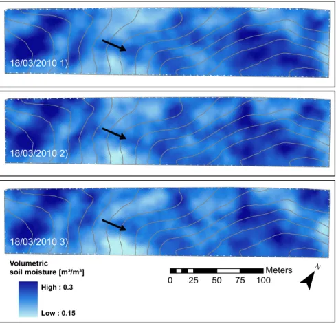
0 25 50 75 100 Meters Volumetric soil moisture [m³/m³] High : 0.3 Low : 0.15 18/03/2010 1) 18/03/2010 2) 18/03/2010 3)
Figure 3: Soil moisture maps for the three acquisitions. Topographic contour lines with an interdistance of one meter are depicted in grey lines. The black arrows indicate the location and the direction of the slope of the main thalweg in the field.
3
Results
3.1
Surface soil moisture maps
Figure 3 presents the interpolated soil moisture maps from the three GPR acquisitions. Soil moisture pat-tern was driven by topography, as the soil and veg-etation conditions were rather homogeneous. High soil moisture values were encountered in the lowest and highest elevated parts of the field, respectively, at the right and left of the figure, where the field is actually quite flat. The center of the thalweg, indi-cated with an arrow on the maps, appeared wetter than its surroundings. The field-average soil mois-ture was equal to about 0.23 m3m−3with a standard
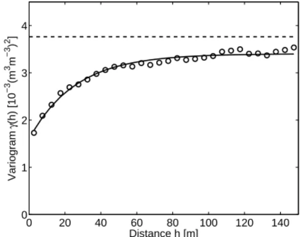
deviation of 0.06 m3m−3, with very similar values between the three repetitions (see Table 1). When optimizing the electrical conductivity in the GPR in-versions, negligible impact was observed on the op-timization of the permittivity ε (mean absolute error of 0.059 in terms of ε comparing to GPR inversions without the optimization of the electrical conductiv-ity). 0 20 40 60 80 100 120 140 0 1 2 3 4 Distance h [m] Variogram γ (h) [10 −3 (m 3 m −3 ) 2 ]
Figure 4: Variogram for soil moisture computed along the acquisition lines for the three repetitions. An exponential model is fitted on the variogram es-timates. The sampling variance is indicated by the horizontal dashed line.
The observed soil moisture exhibited a very sim-ilar spatial correlation between the three repetitions, so that a unique variogram was used for interpolat-ing the soil moisture point measurements (Fig. 4). An exponential model was fitted over the variogram estimates (nugget = 1.60 10−3(m3m−3)2, partial sill
= 1.80 10−3(m3m−3)2, range = 77 m).
3.2
Inversion uncertainties
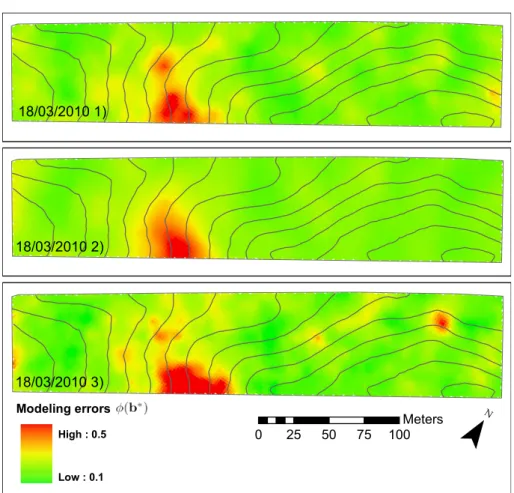
Inverted parameter uncertainties are affected by both modeling error and model sensitivity to the
param-eters (see Eq. (6)). Figure 5 shows the maps of the interpolated modeling error for the three repetitions. The modeling errors appeared to be spatially and temporally correlated. The spatial correlation was moderate, with nugget/sill ratios of 0.66, 0.66 and 0.49, for the three repetitions, respectively. How-ever, the coefficients of correlation between the three repetitions ranged from 0.81 to 0.87, indicating large temporal correlations, as it could be expected from a visual comparison of the three maps. In particular, a patch of the field, situated in the middle left along the bottom limit of the field, was affected by a very high modeling error compared to the rest of the field. Furthermore, the location and the shape of the patch remained identical between the three repetitions.
0 0.1 0.2 0.3 0.4 0.5 0 0.1 0.2 0.3 0.4 0.5 0.6 0.7 0.8 √ J T J θV
Figure 6: Observed sensitivity of the electromag-netic model, expressed by the sum of the elements of the Jacobian matrix for the permittivity, as a func-tion of inverted soil moisture.
Figure 6 presents the observed model sensitivity to the permittivity, i.e., the sum of the elements of the Jacobian matrix for the permittivity, as a function of inverted soil moisture for the first repetition. The sensitivity of the electromagnetic model to the di-electric permittivity was decreasing with increasing soil moisture. It indicated that for high soil moisture, a large variation of soil moisture results in a small variation of the model response. It is worth mention-ing that the sensitivity is presented here as a function of soil moisture, instead of soil dielectric permittiv-ity. Nevertheless, the relationship between dielectric permittivities and model sensitivity appeared simi-lar, although more curved.
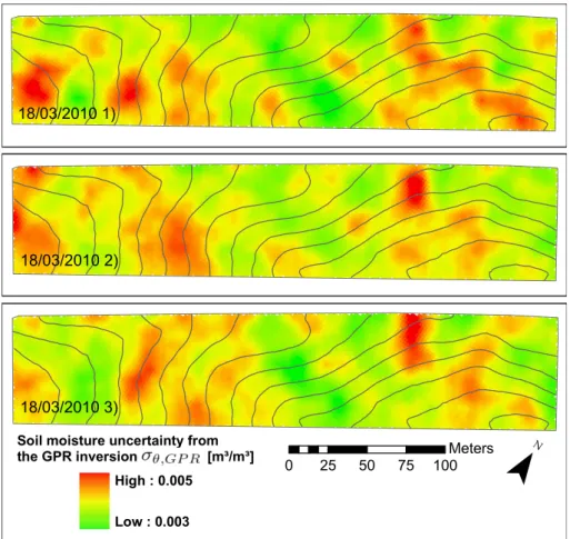
Figure 7 presents the maps of the interpolated soil moisture uncertainty σθ,GP R for the three
rep-etitions. The soil moisture uncertainties appeared very small, with a mean equal to 0.0039 m3m−3
for the three repetitions. As well as for the mod-eling error maps (Fig. 5), soil moisture uncertainties appeared temporally and spatially correlated. The
Table 1: Statistics of GPR-derived volumetric soil moisture [m3m−3] (non-interpolated values)
Repetition µθ medianθ σθ θmin θmax
1 0.234 0.227 0.063 0.053 0.445 2 0.236 0.232 0.061 0.054 0.456 3 0.233 0.230 0.063 0.051 0.436 0 25 50 75 100 Meters Modeling errors High : 0.5 Low : 0.1 18/03/2010 1) 18/03/2010 2) 18/03/2010 3)
Figure 5: Maps of the interpolated modeling error ϕ(b∗). Topographic contour lines with an interdistance of one meter are depicted in grey lines.
0 25 50 75 100 Meters
18/03/2010 1)
18/03/2010 2)
18/03/2010 3)
Soil moisture uncertainty from the GPR inversion [m³/m³]
High : 0.005 Low : 0.003
Figure 7: Maps of the soil moisture uncertainty σθ,GP Rcomputed using Eqs (5) to (8). Topographic contour
σθ,GP R pattern (Fig. 7) resulted from the
combi-nation of the modeling errors (Fig. 5) and the soil moisture sensitivity, which is inversely related to the soil moisture pattern (Fig. 3). As the relationship between soil moisture and model sensitivity to the permittivity is clearly defined (see Fig. 6), the soil moisture uncertainty maps is inversely related with the soil moisture pattern, with a coefficient of corre-lation of 0.403 between θ and σθ,GP Rfor the
non-interpolated values. When optimizing the electrical conductivity in the GPR inversions, the uncertain-ties in ε were poorly affected (mean absolute error of 0.038 in terms of ε). The uncertainties in elec-trical conductivity were however abnormally high with values outside of the realistic physical range for soils, as a result of the poor sensitivity of this param-eter to the model in that frequency range and for low conductive conditions.
The assumption of linearity of the electromag-netic model to its parameters was asserted by per-forming Markov-Chain Monte-Carlo sampling of the parameter space. The standard deviations of the complete posterior distributions of the optimized pa-rameter and the uncertainties computed using the method of Kool and Parker (1988) appeared re-markably similar (results not shown). The use of a Markov-Chain Monte-Carlo sampling is therefore unnecessary, knowing that it requires about 1000 times more computation time.
3.3
Repetition uncertainties
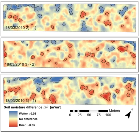
The interpolated soil moisture maps (Fig. 3) showed very similar patterns when comparing the three rep-etitions, with coefficients of correlation of 0.87 tween the first and second repetitions, 0.88 tween the second and third repetitions and 0.81 be-tween the first and third repetitions. Figure 8 shows the repetition uncertainty maps (i.e, the difference in interpolated soil moisture of each repetition to each other ∆θ) between the three repetitions. The global repetition errors RMSErepwere found to be
equal to 0.0164, 0.0156 and 0.0186 m3m−3 for the
three maps, respectively. The repetition uncertainty patterns were poorly spatially correlated, although some parts of the field exhibited small patches of similar repetition uncertainties. Some similitude could be observed with the modeling error maps (Fig. 5). In particular, the patch of high model-ing error in the middle left along the bottom limit of the field corresponded here to larger repetition er-rors than the rest of the field.
A part of the observed differences ∆θ can be at-tributed to the effect of the interpolation, knowing that different sets of measurements were used for interpolating at same locations. The field-averaged
deviations of the difference between the repetitions
σ∆θ computed by Eq. (9) were found to be equal
to 0.0143, 0.0141 and 0.0143 m3m−3 for the three
maps shown in Fig. 8, respectively, denoting that the interpolation effect accounted for a large part in the observed discrepancies between repetitions. The zones delineated in Fig. 8 with black lines highlight the places where the standardized difference of the interpolated soil moisture ∆θ∗(see Eq. (10)) is out-side of the range [-2, 2], i.e., the zones where the two repetitions of the acquisition resulted in different soil moisture estimates at 95 % of confidence level, in-dependently of the interpolation effect. These zones were rather small and appeared randomly located in the field. Finally, it is worth noting that the dif-ference between the first and third repetition was larger than between the other repetitions, i.e., the RMSErep1,3was the largest and the zones of
differ-ent soil moisture estimates were the most extended. This could indicate a real change in soil moisture as the elapsed time between the first and third repeti-tions was the largest (two hours instead of one hour).
3.4
Comparison with soil sampling
measurements
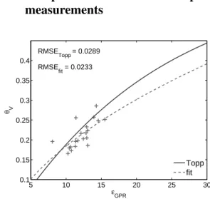
5 10 15 20 25 30 0.1 0.15 0.2 0.25 0.3 0.35 0.4 RMSE Topp = 0.0289 RMSE fit = 0.0233 εGPR θV Topp fitFigure 9: Comparison between interpolated GPR-derived soil dielectric permittivity εGP Rand
volu-metric sampling soil moisture θV.
Figure 9 presents the comparison between in-terpolated GPR-derived soil dielectric permittivity
εGP R using the three repetitions and volumetric
soil moisture θV from the soil sampling
measure-ments. A simple petrophysical (Ledieu et al., 1986) (Eq. (4)) was fitted over the data and the stan-dard relationship of Topp et al. (1980) (Eq. (3)) was also drawn for comparison. There was a good agreement between the soil permittivity and mois-ture, with a RMSEf it of 0.0233 m3m−3 when
0 25 50 75 100 Meters Soil moisture difference [m³/m³]
High : 0.05 Low : -0.05
18/03/2010 2) - 1)
18/03/2010 3) - 2)
18/03/2010 3) - 1)
Figure 8: Maps of the repetition uncertainties for the three acquisitions. The repetition uncertainty is computed as the difference between the interpolated values of each repetitions. The black lines delineated the zones where the two repetitions of the acquisition resulted in different soil moisture estimates, at 95 % of confidence.
with the Topp’s relationship (RMSET opp = 0.0289
m3m−3). The Topp’s and fitted relationships were
therefore in good agreement, except for high soil moisture. When considering the three repetitions for interpolating the GPR-derived permittivity sep-arately, RMSEf itwere equal to 0.0222, 0.0216 and
0.0259 m3m−3for the three repetitions, respectively (Table 2).
4
Discussions
4.1
Inversion uncertainties
The GPR-derived soil moisture uncertainties thus re-sulted from the combination of the modeling error and the soil moisture sensitivity. The decreasing model sensitivity with increasing soil moisture is re-lated to the non-linearity of the Fresnel reflection coefficient function with the soil dielectric permit-tivity for an air/soil interface. The non-linearity of the petrophysical model relating the soil permittivity to the soil moisture reduces the degree of this non-linearity, but not to a sufficient extent. However, it is worth noting that for TDR and GPR methods that are based on the determination of the travel time of the wave propagation rather than on the surface re-flection coefficient, the relationship between the soil moisture and the travel time is linear, assuming a Ledieu’s like petrophysical relationship (Herkelrath et al., 1991; Huisman et al., 2001).
Non-null modeling errors indicated model inade-quacies, i.e., the soil differed from the homogeneous medium it was supposed to be. The large spatial and temporal correlation and the similar patterns ob-served in the modeling error maps (Fig. 5) and, to a lesser extent, in the other uncertainty maps (Fig. 7 and 8), denoted that model inadequacies were prob-ably related to local soil conditions, especially be-cause modeling errors appeared to be spatially corre-lated when considering adjacent acquisition tracks. The model inadequacies caused a large modeling er-ror (Fig. 5), that, in turn may impair the capacity of the GPR to sense the same soil moisture at each repetition (Fig. 8). As the errors appeared strongly dependent on local conditions rather than being ran-domly distributed or time-dependent, this therefore discarded the hypothesis of errors caused by a sensor drift, vibrations of the platform, or any measurement problems that are not linked to local soil conditions. High electrical conductivity, surface soil rough-ness and within-support heterogeneities were identi-fied as the hypothetic model inadequacies and were discussed below. First, highly conductive soils con-ditions may impact on the retrieval of the dielec-tric permittivity in the GPR inversion if not well ac-counted for (Giroux and Chouteau, 2010).
Never-theless, in our study, optimizing the electrical con-ductivity in the GPR inversions did not impact on the retrieval of dielectric permittivities nor on the in-version uncertainties of dielectric permittivities. The huge uncertainties in electrical conductivity denoted a complete insensitivity of this parameter to the elec-tromagnetic model, as already observed in Lambot et al. (2006b) for conductivity values lower than 0.01 S/m, using the same GPR system and a similar fre-quency bandwidth (i.e., 100-900 MHz). As a result, GPR inversions neglecting the optimization of the electrical conductivity were used in this study.
Second, large surface soil roughness may impact on the reflection of the GPR wave by causing inter-ferences. Using the same GPR setup, the effect of surface roughness on the retrieval of the dielectric permittivity was analyzed in laboratory in Lambot et al. (2006a) and widely discussed in case of field acquisition in Minet et al. (2011). Owing to the rel-atively low-frequency range used in the GPR inver-sion, surface soil roughness may significantly impact only for roughness larger than 5 cm. From visual field observation, we can state that such rough con-ditions were not widely encountered.
Lastly, lateral and vertical soil moisture hetero-geneities within the GPR antenna footprint, which is assumed to be an homogeneous medium, could be an important cause of model inadequacy. The ef-fect of vertically-varying soil moisture was investi-gated through numerical and laboratory experiments in Minet et al. (2010a) and in field conditions in Minet et al. (2011). In the presence of a shallow soil layer of a different moisture content than the sublayer, a RMSE of 0.05 m3m−3in the soil
mois-ture estimation was obtained (Minet et al., 2010a, laboratory experiment). For small contrast between the layers (< 0.05), the error was nevertheless neg-ligible. The presence of a vertically-varying soil moisture profile can be detected in measured Green’s functions over a large frequency bandwidth. Never-theless, in this study, such conditions could not be revealed through an analysis of the Green’s func-tions. The absence of observed profile conditions in the GPR data could originate from a poorly de-veloped soil moisture profile (i.e., small contrast be-tween surface and subsurface) or from a profile that is too deep to be sensed, with respect to the relatively small penetration depth of the GPR. In addition, no differences in the shape of the measured Green’s functions could be observed when comparing GPR data from the zones where low and high uncertain-ties were identified with the different methods. This did not support the use of multi-layered medium in-versions, as it would furthermore increase the inver-sion uncertainties for the optimized parameters.
4.2
Repetition uncertainties
A large part of the repetition uncertainties was ex-plained by interpolation effects, given that differ-ent point measuremdiffer-ents were used for each repeti-tion. This could be related to the small-scale spa-tial variability of soil moisture and the relatively large nugget effect observed in the variogram. It is worth mentioning that this variance of the difference increases with the spacing between point measure-ments of two repetitions.
The residual repetition uncertainties that were not explained by the interpolation process may indicate either a real change in soil moisture or a different sensing of soil moisture by the GPR. The slightly larger difference between the first and third repe-titions seemed to indicate a real change that could originate from surface evaporation or a slight soil compaction caused by the ATV, although these pro-cesses could not be explicitly proved.
Using cross-boreholes GPR measurements, Alumbaugh et al. (2002) found a repeatability error of 0.54 ns in the ground wave velocity, cor-responding to a soil moisture error of about 0.005 m3m−3. Errors were increasing with soil moisture
and were attributed to instrument instability. When comparing repeated CMP surface measurements, Jacob and Hermance (2004) found a precision of 0.7 ns in the two-way travel time. Huisman and Bouten (2003) reached a reproducibility of 0.003 m3m−3 when using single trace analysis of GPR ground wave data for soil moisture determination. In these studies, no uncertainties due to the interpo-lation and small-scale variability were taking part, which are however determinant for the repetitions uncertainties in our study.
4.3
Comparison with soil sampling
measurements
The high accuracy of the GPR method for soil mois-ture sensing was established from the comparison with soil sampling measurements. The use of the Topp’s relationship was also validated. However, the small range of permittivity values did not per-mit to verify this agreement over the full physical range of soil moisture. The observed discrepancies can be attributed to the different support scales and depths of characterization of the techniques, with re-spect to the important small-scale variability of soil moisture. Spatially-varying soil properties makes the use of a unique petrophysical model for the whole field questionable as well. In addition, soil moisture values from the soil sampling points were compared with interpolated dielectric permittivity, as both measurements were not taken exactly at the
same locations, at least in the same acquisition line. Therefore, interpolation uncertainties can explain a large part of the observed discrepancies. Lastly, soil moisture values from sampling measurements can be affected by measurements errors as well.
The comparison of the GPR estimates with soil sampling measurements or other invasive measure-ments in field conditions is actually problematic be-cause of the different support scales of the tech-niques. Using the same off-ground GPR in field conditions, Jadoon et al. (2010a) found a RMSE of 0.025 m3m−3between TDR and GPR estimates, but
a soil moisture variability of 0.02 to 0.07 m3m−3
was measured by TDR within each GPR footprint. Therefore, knowing this important submetric vari-ability, it is problematic to compare a soil core sam-ple (3 cm diameter) with the GPR antenna foot-print (∼1.5 m diameter). With respect to the depths of penetration, Jadoon et al. (2010a) found that the GPR waves may sense the soil moisture up to 4 cm depth (which was close to the sampling depth of the core (5 cm)) but it is worth noting that this depth actually varies depending on the soil moisture itself. Considering the whole field, the use of a unique petrophysical relationship may be affected by some limitations as this relationship may depend on the specific local soil conditions (e.g., soil texture, porosity). In addition, the use of different petrophys-ical models, even when calibrated with field data, can result in differences in terms of volumetric soil moisture up to 0.10 m3m−3(Sambuelli, 2009; Steel-man and Endres, 2010). Despite these important limitations, the comparison with soil sampling mea-surements is still the only method for quantifying the accuracy of the GPR method, in addition to its pre-cision.
4.4
Comparison of the uncertainties
In this section, we discuss the global soil moisture uncertainties quantified by the different methods and averaged over the whole field (Table 2). The two first uncertainties assessment methods, i.e., inver-sion and repetition uncertainties, evaluated the pre-cision of the GPR technique while the comparison with ground-truth of soil moisture also evaluated its accuracy. The lowest uncertainties were the GPR inversion uncertainties σθ,GP R, which were derived
from GPR inversions only, i.e., without influence of the interpolation effects. It is however unknown to what extent this represented the total uncertainty as-sociated with a GPR measurement.
The global repetition errors RMSErepcould be
as-sumed to result from the combination of the point measurement uncertainty and the uncertainty asso-ciated with the interpolation. It can be noticed that,
Table 2: Summary of the soil moisture uncertainties [m3m−3] determined by the different methods
GPR inversion uncertainties (σθ,GP R) Comparison with soil sampling (RMSEf it)
Repetition 1 0.00392 0.0222
Repetition 2 0.00398 0.0216
Repetition 3 0.00394 0.0259
All 0.0039 0.0233
Repetition uncertainties (RMSErep) Deviation of the difference (σ∆θ)
Repetition 1 vs 2 0.0164 0.0143
Repetition 2 vs 3 0.0156 0.0141
Repetition 1 vs 3 0.0186 0.0143
All 0.0169 0.0142
globally, the values of the RMSErepappeared to be
close to the sum of the mean GPR inversion uncer-tainties σθ,GP Rand of the deviation of the difference
in the interpolated values σ∆θ, this latter
account-ing for the major part of the repetition error. Never-theless, locally, the repetition uncertainty could not be seen as simply the sum of σθ,GP R and σ∆θ, as
it can be verified by a close examination of Figs. 7 and 8. In addition, repetition uncertainties might be also influenced by a real change of soil moisture, which could not be quantified given its expected mi-nor changes.
The largest uncertainty was found when compar-ing the interpolated GPR-derived permittivity to the soil moisture sampling measurements (Fig. 9), as this inherently combined the uncertainty from the GPR measurement and inversion, the interpolation of soil moisture and the reliability of the petrophys-ical relationship θ-ε. Nevertheless, these uncertain-ties remained weak as compared to previous studies and with respect to the range of soil moisture mea-sured in the field (∼0.15 m3m−3).
The nugget effect, corresponding to a deviation of 0.0400 m3m−3, was assumed to reflect the
com-bined effect of the small-scale variability of soil moisture and the measurement uncertainty. How-ever, this nugget effect appeared to be larger than the uncertainties in soil moisture determined in this study. This is an important finding with respect to the sampling strategies when measuring soil mois-ture with the proposed GPR method. It is particu-larly encouraging that the uncertainty in soil mois-ture measured by GPR appeared lower than the soil moisture variability at the support and resolution scales of the GPR acquisition.
5
Conclusions and perspectives
We evaluated the uncertainties in surface soil mois-ture sensing and mapping of a 2,5 ha agricultural field by full-waveform inversion of GPR data in a
comprehensive manner by three independent uncer-tainty assessment methods.
1. The global uncertainty from the GPR inversion, that is, the point measurement uncertainty, was very low, i.e, 0.0039 m3m−3. Locally, this un-certainty was large for high soil moisture val-ues (lower sensitivity) and for high modeling errors.
2. The global repetition error was found to be equal to 0.0169 m3m−3 and was largely at-tributed to the interpolation effect.
3. The accuracy of the GPR method was evaluated by the comparison with soil sampling measure-ments (ground-truth) and resulted in a RMSE of 0.0233 m3m−3, mainly due to the different
support scales of the techniques.
The soil moisture sensing by the GPR system thus appeared to be very precise, reproducible and in a good agreement with ground-truthing. The three independent uncertainty assessment methods permitted to investigate the different sources of er-rors in soil moisture mapping and the interpolation appeared to be an important source of uncertainty. Furthermore, the uncertainties were mapped and lo-cal spots of high uncertainty were discussed. The temporal and spatial correlation of the uncertainties seemed to indicate that a part of the uncertainties originated from local model inadequacies, but these latter could not be clearly identified nor accounted for.
The evaluated GPR method for soil moisture sens-ing and mappsens-ing shows very promissens-ing potentiali-ties for measuring the soil moisture at an intermedi-ate scale between the remote sensing platforms and invasive sensors. Potential applications are the val-idation of remote sensing products, the analysis of the temporal stability of soil moisture patterns and other hydrology-related applications. In particular, the high spatial resolution of the GPR acquisitions may be combined with the high temporal resolution
of grounded sensors network for an unprecedented spatiotemporal characterization of soil moisture pat-terns.
6
Acknowledgements
We acknowledge Guido Rentmeesters for the GPR platform construction. The research presented in this paper was funded by the Belgian Science Policy Of-fice in the frame of the Stereo II programme - project SR/00/100 (HYDRASENS), the DIGISOIL project financed by the European Commission under the 7th Framework Programme for Research and Techno-logical Development, Area ”Environment”, Activity 6.3 ”Environmental Technologies” and the Fonds de la Recherche Scientifique (FNRS), Belgium.
References
Alumbaugh, D., Chang, P., Paprocki, L., Brainard, J., Glass, R. J., Rautman, C. A., 2002. Estimating moisture contents in the vadose zone using cross-borehole ground penetrating radar: A study of accuracy and repeatability. Water Resources Re-search 38, 1309.
Benedetto, A., 2010. Water content evaluation in un-saturated soil using GPR signal analysis in the fre-quency domain. Journal of Applied Geophysics 71 (1), 26–35.
Bikowski, J., van der Kruk, J., Huisman, J. A., Vereecken, H., Vrugt, J. A., 2010. Inversion and sensitivity analysis of GPR data with waveguide dispersion using Markov Chain Monte Carlo sim-ulation. In: Proceedings of the XIII International Conference on Ground Penetrating Radar. Lecce (Italy), 21-25 June 2010, pp. 722–726.
Birchak, J. R., Gardner, C. G., Hipp, J. E., Victor, J. M., 1974. High dielectric constant microwave probes for sensing soil moisture. Proc. IEEE 62, 93–102.
Bogena, H., Herbst, M., Huisman, J., Rosenbaum, U., Weuthen, A., Vereecken, H., 2010. Potential of Wireless Sensor Networks for Measuring Soil Water Content Variability. Vadose Zone Journal 9, 1002–1013.
Chanzy, A., Tarussov, A., Judge, A., Bonn, F., 1996. Soil water content determination using digi-tal ground penetrating radar. Soil Science Society of America Journal 60, 1318–1326.
Dobson, M. C., Ulaby, F. F., Hallikainen, M. T., El-Rayes, M. A., 1985. Microwave dielectric behav-ior of wet soil - Part II: Dielectric mixing mod-els. IEEE Transactions on Geoscience and Re-mote Sensing 23, 35–46.
Galagedara, L. W., Parkin, G. W., Redman, J. D., P., Endres, A. L., 2005. Field studies of the GPR ground wave method for estimating soil water content during irrigation and drainage. Journal of Hydrology 301, 182–197.
Giroux, B., Chouteau, M., 2010. Quantitative anal-ysis of water-content estimation errors using ground-penetrating radar data and a low-loss ap-proximation. Geophysics 75 (4), WA241–WA249. Grote, K., Anger, C., Kelly, B., Hubbard, S., Rubin, Y., 2010. Characterization of Soil Water Content Variability and Soil Texture using GPR Ground-wave Techniques. Journal of Environmental and Engineering Geophysics 15 (3, Sp. Iss. SI), 93– 110.
Grote, K., Hubbard, S. S., Rubin, Y., 2003. Field-scale estimation of volumetric water content using GPR ground wave techniques. Water Resources Research 39(11), 1321.
Herkelrath, W. N., Hamburg, S. P., Murphy, F., 1991. Automatic, real-time monitoring of soil moisture in a remote field area with time domain reflectom-etry. Water Resources Research 27 (5), 857–864. Huisman, J. A., Bouten, W., 2003. Accuracy and
reproducibility of measuring soil water content with the ground wave of ground-penetrating radar. Journal of Environmental and Engineering Geo-physics 8(2), 65–73.
Huisman, J. A., Hubbard, S. S., Redman, J. D., An-nan, A. P., 2003. Measuring soil water content with ground penetrating radar: A review. Vadose Zone Journal 2, 476–491.
Huisman, J. A., Snepvangers, J. J. J. C., Bouten, W., Heuvelink, G. B. M., 2002. Mapping spatial vari-ation in surface soil water content: comparison of ground-penetrating radar and time domain reflec-tometry. Journal of Hydrology 269, 194–207.
Huisman, J. A., Sperl, C., Bouten, W., Verstraten, J. M., 2001. Soil water content measurements at different scales: accuracy of time domain reflec-tometry and ground penetrating radar. Journal of Hydrology 245, 48–58.
Jacob, R. W., Hermance, J. F., 2004. Assessing the precision of GPR velocity and vertical two-way travel time estimates. Journal of Environmental and Engineering Geophysics 9 (3), 143–153.
Jadoon, K. Z., Lambot, S., Scharnagl, B., van der Kruk, J., Slob, E., Vereecken, H., 2010a. Quan-tifying field-scale surface soil water content from proximal gpr signal inversion in the time domain. Near Surface Geophysics 8, 483–491.
Jadoon, K. Z., Lambot, S., Slob, E., Vereecken, H., 2010b. Investigation of the frequency dependent antenna transfer functions and phase center posi-tion for modeling off-ground gpr. IEEE Transac-tions on Geoscience and Remote Sensing In press.
Jonard, F., Weiherm¨uller, L., Jadoon, K., Schwank, M., Vereecken, H., Lambot, S., 2010. Mapping field-scale soil moisture with L-band radiometer and ground-penetrating radar over bare soil. IEEE Transactions on Geoscience and Remote Sensing In press.
Kool, J. B., Parker, J. C., 1988. Analysis of the Inverse Problem for Transient Unsaturated Flow. Water Resources Research 24, 817–830.
Lambot, S., Antoine, M., Vanclooster, M., Slob, E. C., 2006a. Effect of soil roughness on the in-version of off-ground monostatic GPR signal for noninvasive quantification of soil properties. Wa-ter Resources Research 42, W03403.
Lambot, S., Slob, E. C., Chavarro, D., Lubczyn-ski, M., Vereecken, H., 2008. Measuring soil sur-face water content in irrigated areas of southern Tunisia using full-waveform inversion of proxi-mal GPR data. Near Surface Geophysics 6, 403– 410.
Lambot, S., Slob, E. C., van den Bosch, I., Stock-broeckx, B., Vanclooster, M., 2004. Modeling of ground-penetrating radar for accurate charac-terization of subsurface electric properties. IEEE Transactions on Geoscience and Remote Sensing 42, 2555–2568.
Lambot, S., Weiherm¨uller, L., Huisman, J. A., Vereecken, H., Vanclooster, M., Slob, E. C., 2006b. Analysis of air-launched ground-penetrating radar techniques to measure the soil surface water content. Water Resources Research 42, W11403.
Ledieu, J., De Ridder, P., De Clercq, P., Dautre-bande, S., 1986. A method of measuring soil moisture by time domain reflectometry. Journal of Hydrology 88, 319–328.
Lunt, I. A., Hubbard, S. S., Rubin, Y., 2005. Soil moisture content estimation using ground-penetrating radar reflection data. Journal of Hy-drology 307 (1-4), 254–269.
Marquardt, D. W., 1963. An algorithm for least-squares estimation of nonlinear parameters. Jour-nal of the Society for Industrial and Applied Mathematics 11, 431–441.
Minet, J., Lambot, S., Slob, E., Vanclooster, M., 2010a. Soil surface water content estimation by full-waveform GPR signal inversion in the pres-ence of thin layers. IEEE Transactions on Geo-science and Remote Sensing 48, 1138 – 1150.
Minet, J., Patriarca, C., Slob, E., Vanclooster, M., Lambot, S., 2010b. Characterization of layered media using full-waveform inversion of proximal GPR data. In: Proceedings of the USRI Inter-national Symposium on Electromagnetic Theory - EMTS2010. Berlin (Germany), 16-19 August 2010.
Minet, J., Wahyudi, A., Bogaert, P., Vanclooster, M., Lambot, S., 2011. Mapping shallow soil mois-ture profiles at the field scale using full-waveform inversion of ground penetrating radar data. Geo-derma 161, 225–237.
Redman, J. D., Davis, J. L., Galagedara, L. W., Parkin, G. W., 2002. Field studies of GPR air launched surface reflectivity measurements of soil water content. In: Koppenjan, S., Hua, L. (Eds.), Proceedings of the Ninth International Confer-ence on Ground Penetrating Radar. Santa Barbara, California, USA, pp. SPIE 4758:156–161.
Robinson, D. A., Binley, A., Crook, N., Day-Lewis, F. D., Ferre, T. P. A., Grauch, V. J. S., Knight, R., Knoll, M., Lakshmi, V., Miller, R., Nyquist, J., Pellerin, L., Singha, K., Slater, L., 2008a. Advancing process-based watershed hydrologi-cal research using near-surface geophysics: a vision for, and review of, electrical and mag-netic geophysical methods. Hydrological Pro-cesses 22 (18), 3604–3635.
Robinson, D. A., Campbell, C. S., Hopmans, J. W., Hornbuckle, B. K., Jones, S. B., Knight, R., Og-den, F., Selker, J., Wendroth, O., 2008b. Soil moisture measurement for ecological and hydro-logical watershed-scale observatories: A review. Vadose Zone Journal 7 (1), 358–389.
Sambuelli, L., 2009. Uncertainty propagation using some common mixing rules for the modelling and interpretation of electromagnetic data. Near Sur-face Geophysics 7 (4, Sp. Iss. SI), 285–296.
Serbin, G., Or, D., 2003. Near-surface water content measurements using horn antenna radar: method-ology and overview. Vadose Zone Journal 2, 500– 510.
Serbin, G., Or, D., 2005. Ground-penetrating radar measurement of crop and surface water content dynamics. Remote Sensing of Environment 96, 119–134.
Slob, E., Sato, M., Olhoeft, G., 2010. Surface and borehole ground-penetrating-radar developments. Geophysics 75 (5), A103–A120.
Steelman, C. M., Endres, A. L., 2010. Comparison of petrophysical relationships for soil moisture es-timation using gpr ground waves. Vadose Zone Journal In press.
Topp, G. C., Davis, J. L., Annan, A. P., 1980. Elec-tromagnetic Determination of Soil Water Content: Measurements in Coaxial Transmission Lines. Water Resources Research 16, 574–582.
van der Kruk, J., 2006. Properties of surface waveg-uides derived from inversion of fundamental and higher mode dispersive GPR data. IEEE Transac-tions on Geoscience and Remote Sensing 44 (10), 2908–2915.
van der Kruk, J., Jacob, R. W., Vereecken, H., 2010. Properties of precipitation-induced multi-layer surface waveguides derived from inversion of dispersive TE and TM GPR data. Geophysics 75 (4), WA263–WA273.
Van Orshoven, J., Vandenbroucke, D., 1993. Guide de l’utilisateur d’aardewerk, base de donn´ees p´edologiques, institute for land and water man-agement, k.u. leuven, leuven, belgium. Tech. rep. Vereecken, H., Huisman, J. A., Bogena, H., Vander-borght, J., Vrugt, J. A., Hopmans, J. W., 2008. On the value of soil moisture measurements in vadose zone hydrology: A review. Water Resources Re-search 44, W00D06.
Vrugt, J. A., ter Braak, C. J. F., Diks, C. G. H., Robinson, B. A., Hyman, J. M., Higdon, D., 2009. Accelerating Markov Chain Monte Carlo Simulation by Differential Evolution with Self-Adaptive Randomized Subspace Sampling. Inter-national Journal of Nonlinear Sciences and Nu-merical Simulation 10 (3), 273–290.
Wagner, W., Bl¨oschl, G., Pampaloni, P., Calvet, J. C., Bizzarri, B., Wigneron, J. P., Kerr, Y., 2007. Operational readiness of microwave remote sens-ing of soil moisture for hydrologic applications. Nordic Hydrology 38 (1), 1–20.
Weiherm¨uller, L., Huisman, J. A., Lambot, S., Herbst, M., Vereecken, H., 2007. Mapping the spatial variation of soil water content at the field scale with different ground penetrating radar tech-niques. Journal of Hydrology 340, 205–216.


![Table 2: Summary of the soil moisture uncertainties [m 3 m − 3 ] determined by the different methods GPR inversion uncertainties (σ θ,GP R ) Comparison with soil sampling (RMSE f it )](https://thumb-eu.123doks.com/thumbv2/123doknet/5599236.134688/15.892.128.768.141.342/summary-uncertainties-determined-different-inversion-uncertainties-comparison-sampling.webp)
